
Stage 28 – Kazakhstan & Kyrgyzstan: The Kazakh Steppe [2/2]
Until the disastrous Soviet program of forced collectivisation in the 1920s, the Kazakhs were an almost entirely nomadic society, who by their very nature left little mark on the land they inhabited. In the month I had just spent in Kazakhstan, making my way from the Russian border in the north-west to the extreme south of the country, I had passed many of the country’s oldest cities, some reduced to lifeless piles of dust, others surviving to this day. All however were the product of the settled societies which stretched south to Persia. Having made a brief side-trip into Kyrgyzstan to renew my visa, I had four more weeks of travel ahead of me in Kazakhstan, during which I would penetrate the very heart of the country, to see the subtle yet fascinating legacy of the successive nomadic nations who have inhabited the steppe. Beyond this, I would head for the far south-east of the country, along the Chinese border, where I would find some of Central Asia’s most haunting landscapes.

Petroglyphs, Tamgaly, Almaty Region, Kazakhstan
I re-enter Kazakhstan in the early hours of the 14th May 2011 in the town of Korday, after a sixteen hour side-trip through Kyrgyzstan. I drive east for two more hours before pulling off the highway at the turning north to Kopa, where I continue in daylight after a few hours’ rest. Now in late spring, the steppe is still green and covered in places by huge patches of striking red poppies and purple wild flax flowers. My destination is an isolated spot out on the steppe know as Tamgaly. Here, on the edge of the huge grasslands which stretch north to the edge of Siberia are a series of step-like rocky outcrops with large, smooth blocks and boulders covered in shiny black desert varnish. Tamgaly has a comparative abundance of springs, vegetation and shelter compared to its surroundings and has attracted successive pastoral communities for millennia, who since the Bronze Age have left striking petroglyphs describing their culture and customs.
Tamgaly is indeed perhaps the most interesting of Central Asia’s many petroglyph sites, for it appears to have a central cult area where the stylised rock inscriptions are most prolific and expressive; an area which may have been sacred, with altars used for sacrifices. Alongside the common images of hunting and various animals is a true masterpiece of rock art; a pane showing several large, solar deities (‘sunheads’), animals being enchanted by shamans, and a group of men dancing around a woman giving birth. Dated to the second half of the fourteenth century and thirteenth century BCE, in the Middle Bronze Age, they are a fascinating and deeply intriguing testament to the customs of the distant, steppe-dwelling ancestors of Eurasians.

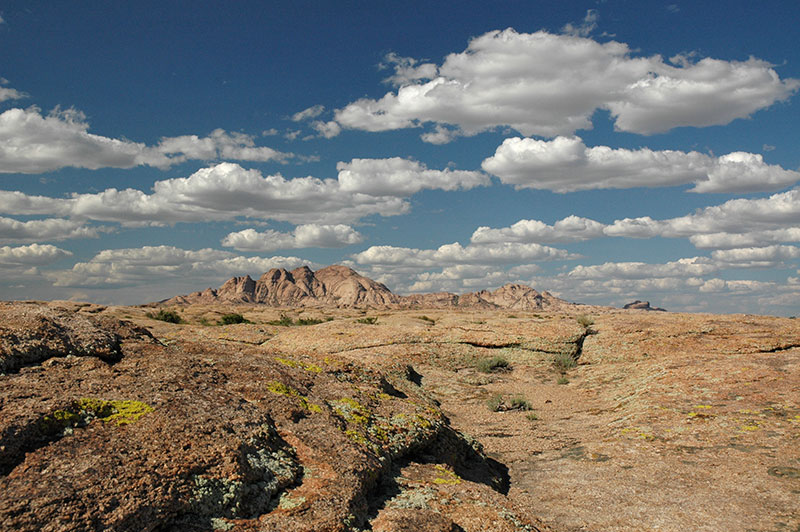
Karatau Mountains, near Kentau, South Kazakhstan Region, Kazakhstan
I return to the main road, doubling back to Taraz where I stop for a few days, then continue towards the low, twisted peaks of the Karatau Mountains, a north-westerly spur of the Tien Shan which also roughly delineates the boundary between historically settled and nomadic civilisations. I pass through the desolate town of Zhanatas, a phosphorite-mining centre which was evidently in the process of expansion when the Soviet Union collapsed in 1991, and with it the market for phosphorite, leaving a town full of huge, empty, decaying apartment buildings around a run down centre, where I am hauled in for passport registration by suspicious police. Beyond Zhanatas the road enters the steppe again, curving through isolated towns such as Sudakent and Chulakkurgan, crossing the low, broken massif of the Karatau Mountains then dropping down via Kentau to Turkistan and the broad Syr Darya Valley. Here I rejoin the main highway down which I had driven last month, retracing my steps to Kyzylorda where I stay for a night before turning north, to the very centre of Kazakhstan.

A381 Highway, Kyzylorda Region, Kazakhstan
The road out of Kyzylorda leaves behind the near-desert of the Syr Darya Valley, entering country which fades imperceptibly into scrubby steppe dotted with saxauls and wormwood, from which tortoises emerge to make the hazardous crawl across the highway. The asphalt soon runs out, but the track has been recently graded and seldom slows my progress. Off to the west I see a low escarpment of brilliant red-orange sandstone, but other than this there is nothing to catch the eye and the journey becomes mesmerising. After several hours I pass a lonely Kazakh cemetery to my right, on the banks of the Sary Suu River. Not long after this the smokestacks of an industrial city loom on the horizon and large, whitewashed concrete letters at the roadside announce my arrival in the city of Zhezkazgan.
Founded in 1938 principally to exploit deposits of copper, and made infamous by Solzhenitsyn’s descriptions of the nearby Kengir Gulag, Zhezkazgan is a surprisingly pleasant city surrounded by hundreds of kilometres of steppe in each direction. Its neat, Khrushchev-era city blocks are dotted with numerous Soviet murals and sculptures, and the city has become associated with space exploration, with returning cosmonauts landing in the vast openness of the nearby steppe and ceremonially planting a tree in the city. I’m hosted in Zhezkazgan by Laura, a Californian Peace Corps Volunteer who immediately takes me to the home of her Kazakh ex-host family where two new volunteers are being welcomed with a traditional dastarkhan (feast) of Kazakh specialities such as baursak (deep fried dough pockets), sweets, fruit and vodka, though thankfully no sheep’s head.
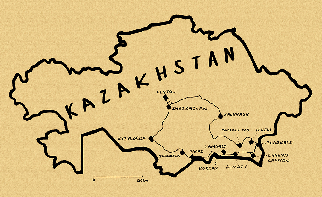
Moustachioed Kurgan, Ulytau, Karaganda Region, Kazakhstan
North of Zhezkazgan is the region of Ulytau, located centrally both in the country, and in the identity of the Kazakh people. On the main road I pass a tall monument to the unity of Kazakh peoples, signifying both the geographical centre of the country and (conveniently) the point where the three Kazakh zhuzes (clans or hordes) came together to fight their common enemy the Dzungars, who came from China in the eighteenth century. The small, nondescript town of Ulytau itself is set amongst low basalt mountains, something of an oasis in the surrounding dry steppe, with rich green grass and even stands of birch trees. With such an attractive steppe environment it is not surprising that the area is of historical importance, with an abundance of archaeological sites. Out in the steppe just east of town are stone kurgans (barrows), which in each case are part of a larger construction, with two curving lines of stones running roughly parallel away from the kurgan to end in a larger standing stone. It is not clear whether these constructions, known as ‘moustachioed’ kurgans are observatories, grave markers, or ritual constructions.
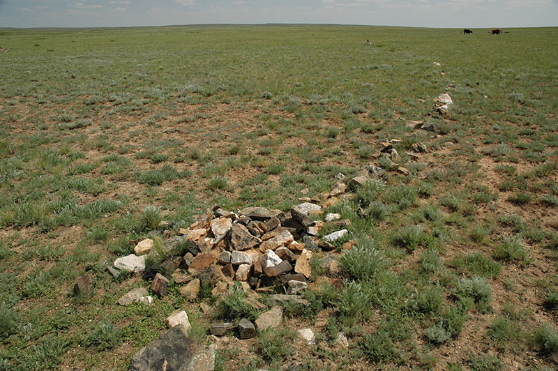
Mausoleum Of Alasha Khan, Karaganda Region, Kazakhstan
The precise origins of Kazakh people are not entirely clear, complicated by the fact that the term ‘Qazaq‘ had been used for centuries to denote a free wanderer (the term ‘Cossack’, for an entirely unrelated ethnic group is likely to come from this root). What does seem firmly routed in truth is that Abu’l-Khayr Khan, a descendent of Chinggis Khan (Genghis Khan) united the nomadic Central Asian tribes in the mid-fifteenth century, and that it was Janibek Khan and Kerei Khan who rebelled from this union to found the Kazakh khanate (tribal chiefdom). What is far less clear is the unification of the three Kazakh zhuzes under a legendary figure known as Alasha Khan.
The day after visiting Ulytau I drive north and east from my night stop in the dull mining town of Satbayev, into the steppe, which here is dotted by beautifully eroded, softly multicoloured hills. Just outside the village of Malshibay is the mausoleum complex attributed to Alasha Khan. It’s a striking building with beautiful (restored) geometric brickwork, thin bands of turquoise tiles and a striking vaulted interior. A thin passageway runs around the chamber between inner and outer walls, and a stairway leads up to the roof. From here there is a fine view overlooking a number of mausolea belonging to lesser notables, some poignantly decayed with broken domes and scattered, fallen masonry. With the main mausoleum dated to the tenth to twelfth centuries, it seems unlikely that Alasha Khan was a real person who united the Kazakhs, but this seems of only minor importance. Groups of locals arrive at the site, saying their prayers standing up, facing the mausoleum’s portal, or sitting on the ground in groups outside one of the smaller mausolea. This is the living continuation of a thick fabric of legends attributed to this area, passed down through generations orally by these wandering, nomadic people of the steppe.

Petroglyphs, Terekty Aul, Karaganda Region, Kazakhstan
From Malshibay I leave the road and head south on tracks back towards Zhezkazgan, reaching another group of mausolea. Here the principal shrine is also red-brick, though coarser than that of Alasha Khan, with a modern turquoise-tiled dome and a plain interior covering two graves, said to be that of Jochi Khan and his wife. Jochi was the first son of Chinggis Khan (quite possibly illegitimate, as his wife Borte gave birth soon after returning from the rival Merkit tribe who had kidnapped her in an earlier battle) and campaigned with his father as the Mongols spread east. However, he seems to have become estranged, possibly following his father’s choice of his younger brother Ögedei as successor, and he never returned to his father’s court in Mongolia, later dying in February 1226 in a hunting accident. It’s tempting to think that this plain mausoleum contains the grave of a son of one of the greatest men in history, but like so many of the scant historical remains on this huge steppe, it is in reality an intriguing mystery.
Kazakh Mausolea, near Kyzylzhar, Karaganda Region, Kazakhstan
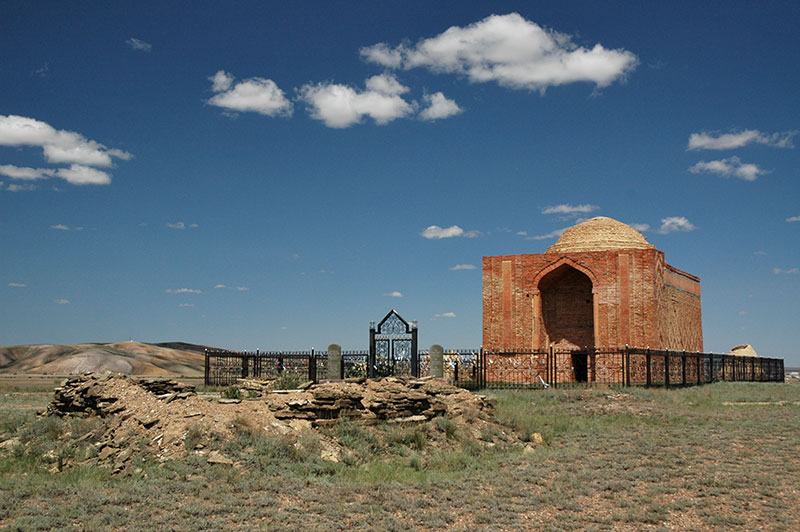
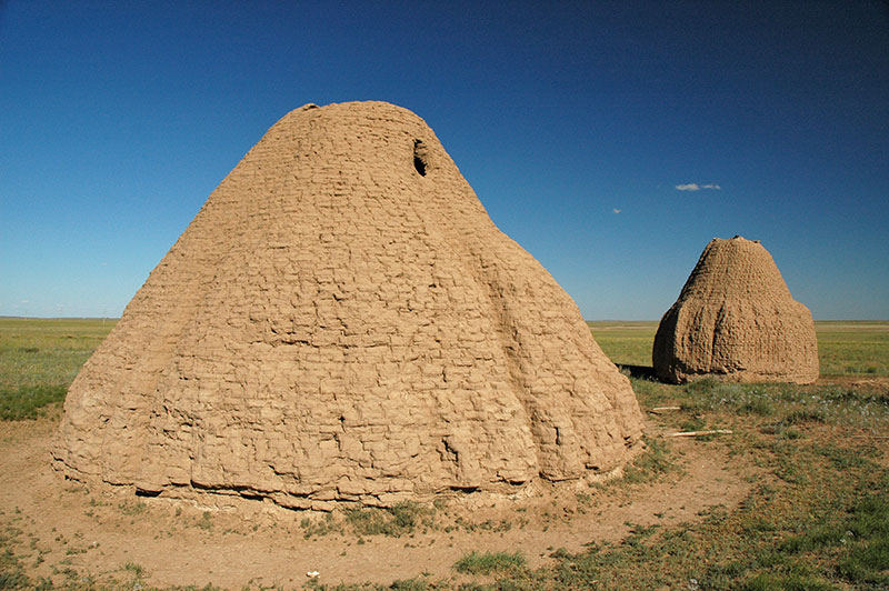
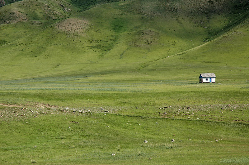
Turning away from Ulytau and Zhezkazgan in the morning, I continue through a similar landscape of rolling green steppe, pulling off the road at a scrubby spot and driving briefly north to see the petroglyphs at Terekty Aul; here carved deeply into the soft pink basalt, rather than the usual picketing into dark, desert-varnished rock. This area too seems to have had some spiritual significance as there are a number of large nearby mausolea. Indeed, all along the road east towards Karaganda the landscape is regularly dotted by ancient graves and shrines, and I find myself drawn to stop at each of them. In one particularly ancient burial ground I find graves spanning right across time; from the most ancient kurgans, through megalithic slab graves, to mud-brick mausolea and finally recent graves, each with a headstone and small perimeter fence. At another stop near Kyzylzhar there are two very large mud-brick mausolea whose flutes have been softened by years of exposure to the elements, giving them the look of two giant lemon-squeezers. I find these silent, deserted burial grounds quite wonderful; perched out on the beautiful green, wormwood-scented steppe, the only visible legacy of a civilisation; nameless graves whose identity has passed into obscurity just like the generations of departed nomads, yet whose very presence on the plains, visible from afar, provides a reassuring ancestral link between the people and their homeland.
Bektau Ata, Karaganda Region, Kazakhstan
Shortly beyond the town of Atasu, where I stop for dinner, I turn south-west off the main highway into an area of beautiful, table-flat steppe defined by distant low mountain ridges, seemingly good, green pasture yet strangely devoid of population. Continuing the following day, through the isolated town of Akadyr and more marvellously empty terrain, I join the country’s main highway, which connects the new capital Astana with Almaty, its largest city, and is in refreshingly good condition. I stop briefly at the beautiful pink-orange basalt massif of Bektau Ata, whose softly-sculpted, lichen-covered volcanic rocks are dotted with lakes and imbued with legends, before continuing to the city of Balkhash. Lake Balkhash is one of the largest in Asia, a shallow, sickle-shaped smear of bright blue water, saline at its eastern end yet composed of freshwater in its larger western section. The exploitation of nearby copper reserves has overtaken fishing as the main economic activity and Balkhash, the principal lakeside settlement is, like Zhezkazgan, a neat and attractive mining city. Streets of colourful Stalinist buildings (many built by Japanese prisoners of war) run down to the turquoise waters of the lake where a sandy beach is dotted with families, giving the city the air of a friendly, unpretentious seaside resort, albeit with a background of smokestacks and other heavy industry, and highly polluted water.
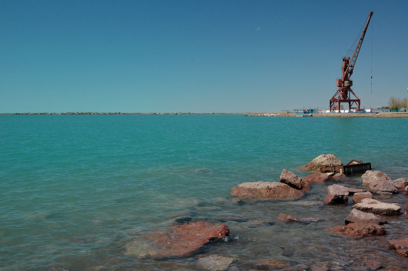
Lake Balkhash, Balkhash, Karaganda Region, Kazakhstan
I continue my journey south through the semi-desert along the curving western edge of the lake, with beautiful views across its reedy shores and peppermint blue waters, passing the site of the Soviet-era Saryshagan Missile Testing Range and reaching the southern edge of the lake in the late afternoon. Beyond the lake, the highway skirts around a barren sandy wasteland, which I enter on a nearly deserted road turning north acutely from the main highway. I cross a bleak area of undulating scrubby dunes for around fifty kilometres before suddenly entering the delta region of the Ili River, which runs from the eastern Tien Shan in China to Lake Balkhash. The delta is a real paradise; a bird-filled wonderland of ponds, reeds, trees and dunes, and after stopping for the day in the waning light, the cool night air is alive with the sound of frogs and buzzing insects; wholly unprecedented given the barren wastes I’ve been driving through for much of the day. This fertile region is known as Zhetysu (Seven Rivers) and until 1864 was part of Qing Dynasty (Manchu) China, with Lake Balkhash forming the border with the Russian Empire.
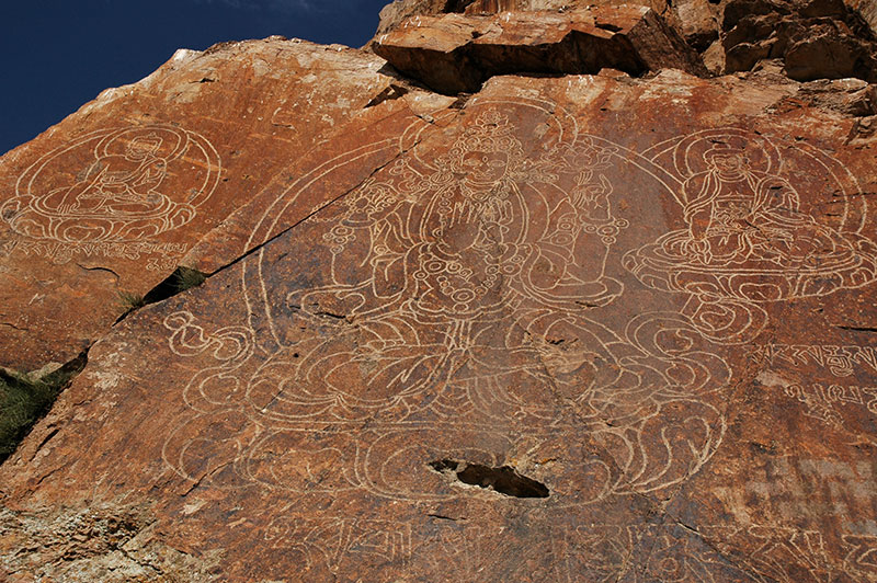
Buddha Images, Tamgaly Tas, Almaty Region, Kazakhstan
The following day I make my way upstream along the Ili River, passing through small farming communities towards Lake Kapchagay, crossing the river on the highway to Almaty then turning downstream briefly, where Ili flows through a broad grassy valley between low hills. Here, on the left bank of the river, beside a natural historical crossing point, is a rocky outcrop known as Tamgaly Tas, which bears the inscriptions of several cultures, from ancient Turkic runic, the instantly-recognisable sharp characters of Tibetan script to very beautiful vertical verses of Dzungar script. The main attraction however are three large carved images of the Buddha on a lotus leaf, the largest, central image in the teaching position, as if giving a sermon on the bank of the river. The exact origin of the Buddhas is unknown, and while a Kazakh legend dates them to the tenth century, it is likely that they are of Dzungar origin. The Dzungars were an Oirat (western Mongol) tribe and the last nomadic civilisation to threaten China. They were also Buddhists from the sixteenth century onwards, and displaced Kazakhs from this area in the mid-seventeenth century, only to be chased back out in the early eighteenth century when weakened by Qing Dynasty China to the east, and thus the carvings are likely to date from between these dates.
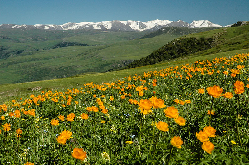
Wildflowers, Dzungarian Alatau, Almaty Region, Kazakhstan
My next destination is Tekeli, an attractive small town set amidst the lower slopes of the Dzungarian Alatau, a 450 kilometre-long range of mountains which define part of the Kazakhstan – China border. I’m hosted here by Thomas, a French expatriate who works in the town’s malting plant, the only one in Central Asia. Tekeli is a pleasant place, and in the nearby Kora Valley we see an ancient carving of a Buddhist stupa on a large rock next to the river, but it is the grassy mountains immediately above town that are truly unforgettable. We drive partway up in Thomas’ company 4×4, then set out on foot heading east and up across rolling hills. Soon we encounter huge flower-filled hillsides, shaded with bright orange poppies, yellow buttercups, blue forget-me-nots, white daisies and purple asters. As we climb higher, we can see into a yawning valley, with long-range views over a succession of emerald-green hills which, on their upper slopes fade immediately into a crest-line of glaciated and snowcapped peaks. Dotting one nearby grassy saddle is a bright-white Kazakh yurt (nomad tent), an iconic image of these once-nomadic people all but absent from the steppes; a vital part of Kazakh culture wiped out by Stalin’s collectivisation. We approach the yurt, inhabited by a friendly Kazakh family who offer us tea and milk. They explain that they spend the summer season here grazing their animals, returning to the nearby city of Taldykorgan for the winter. To glimpse the remnant of an ancient nomadic culture here, in one of the most beautiful places I have ever seen, makes it one of my favourite experiences in all my travels in Kazakhstan.
Dzungarian Alatau, Almaty Region, Kazakhstan
I make my way slowly south-east from Tekeli, crossing to a rough track on the far side of the Koksu River to find the ancient site of Eshkiolmes, where I park the car amongst unexcavatd grave mounds and content myself for several hours walking around the country’s largest petroglyph site, finding perhaps several hundred of the ten-thousand-odd petroglyph images said to be spread over several small side valleys. Continuing south-east I pass more magnificent grassy foothills of the Dzungarian Alatau on quiet back-roads, before dropping down into a corridor between the mountains and the Ili River which contains the main highway running east from Almaty to the Chinese border. Here, on this living remnant of the Silk Road, the landscape reverts very abruptly to the familiar dry plains of wormwood-scented grass, dotted by crumbling mud-brick mausolea in various states of atmospheric decrepitude. Occasional villages and small towns are lined by tall, brush-like poplars and leafy mulberry trees, giving a strong hint of Chinese Turkestan. Bactrian camels appear, corralled in stinking, screeching, indignant herds. I watch as one bolts and dashes with remarkable speed across the steppe, parallel with the road, chased by two horsemen who fail to apprehend it in the time it takes me to drive past the scene. This is classic Central Asia.

Mausolea, near Konyrolen, Almaty Region, Kazakhstan
The busy market town of Zharkent is as far as I go towards the Chinese border, and the province of Xinjiang of which I have such fond memories from a 2003 trip across Asia (by public transport). Here, after finding lunch in a Uyghur cafe, I set out to look at the town’s only architectural attraction, which lies in a large, poplar-flanked courtyard amid the slightly chaotic market streets. The late nineteenth Yuldashev Mosque is a highly unusual Islamic structure created by a Chinese architect; with a tiered, wooden pagoda roof on the main hall and a similar minaret, colonnaded outer walkways and colourful Chinese-style paintings under the roof eaves, the mosque has a very strong resemblance to a Manchu-era Buddhist temple; at once rather attractive and novel, but at the same time lacking the pleasing geometrical grace of classical Islamic architecture. The mosque’s obstructive female caretaker accompanies my every step around the building with thinly disguised contempt, and so I soon leave.
From Zharkent I head south, crossing the Ili and heading straight for Almaty, where I am hosted by Dan, a British expatriate and his Kazakh fiancée Aliya, in their comfortable apartment overlooking the city centre. Dan, an English teacher and Russian speaker is a kind and sensitive guy, and I am glad to meet a fellow Englishman who has an affinity for this country and an appreciation of its history and culture. I was deeply saddened to hear of Aliya’s sudden death a little over a year later, just a few days after they had married in the UK.
Charyn Canyon, Almaty Region, Kazakhstan
I make one final trip east from Almaty, driving along the beautiful green valley at the foot of the Ili Alatau Range which marks the border with Kyrgyzstan. I find that, as suspected, the border crossing into Kyrgyzstan’s Karakara Valley is closed following major social unrest in the country last year. I make a side trip towards the village of Tekes in a beautiful high, flat valley, where the southern horizon is occupied by an endless chain of snowy peaks of the Tien Shan, which run off to the east, at some arbitrary point becoming Chinese territory. I park up for the night in a field, admiring the beauty of my surroundings, and through a brief gap in the high clouds glimpse the 7010-metre peak of Khan Tengri, the second highest peak in the Tien Shan, which marks the point where Kazakhstan, Kyrgyzstan and China come together.
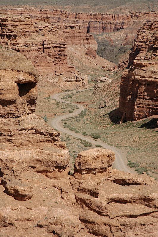
With the nearby border crossing closed, I have no alternative but to turn west once again, back to Almaty and the border crossing at Korday, where I had entered the country four weeks earlier. I stop en route to look at the dramatic Charyn Canyon, which drops down from the green mountain steppe in a beautifully eroded valley of red sandstone, highly reminiscent of the American south-west. The next day I drive to the busy border crossing of Qorday, thus completing a loop of almost six thousand kilometres over the last four weeks on the Kazakh Steppe.
I had entered Kazakhstan for the first time back in 2007, transiting along the eastern edge of the country to the most obvious points of touristic appeal in the south, with the impression that much of the rest of the country was empty, featureless steppe of no interest. On these two visits over the past eight weeks, during which I had crossed much of the country, it became clear that this widely-held impression of Kazakhstan is rather wrong. Indeed, as I explored the steppes and mountains of the country, with their traces of ancient history and magnificently beautiful and varying landscapes, it became perhaps my favourite in the region. With this large blank on my travel-map now reassuringly filled, I was prepared to make a final crossing of Central Asia, back to the Caspian Sea and on to Europe.

Hola! I’ve been reading your website for a long time now and finally got the courage to go ahead
and give you a shout out from Huffman Tx! Just wanted to tell you keep up the excellent job!
Hi Lucile
Thanks for your comment, it’s always nice to hear from someone who reads the articles. Right now I’m writing up the second part of the journey from 2014, I hope you enjoy them.
Best wishes from the Netherlands,
EO