
Stage 28 – Kazakhstan & Kyrgyzstan: The Kazakh Steppe [1/2]
Between the great lowlands of Siberia and the long-settled oasis towns of Central Asia lies the Kazakh Steppe, almost wholly within the Republic of Kazakhstan, by far the world’s largest landlocked country. Larger than all of Western Europe and mostly covered with rolling grassland, I had twice made lengthy road journeys across firstly the east, and then the north of this country. I wished now to explore Kazakhstan more fully, rather than simply transit the country to some other, more obvious destination. Travellers often write-off Kazakhstan as lacking very much of interest, but in my seven weeks driving around this vast country I would discover the beauty, history and welcoming people which lie beyond the country’s main cities. Perhaps most rewarding however was the chance to indulge my love of wide, open spaces; feeling the freedom of moving independently around the steppe amidst lonely traces of ancient history.

Imangaly Mosque, Atyrau, Atyrau Region, Kazakhstan
It’s the 14th April 2011 and I enter Kazakhstan at the village of Zhaysan on the Ilek River, an arbitrary point on the wide, empty grasslands south of Orenburg. My arrival in Kazakhstan has coincided with the complete disappearance of winter snow-cover, replaced by springtime mud. The sudden presence of (albeit muddy) greenery after more than six months of winter monochrome is pleasant enough, but the feeling of being back out amidst the glorious endlessness of the steppe is more deeply soothing. I drive straight to the city of Aktobe, which I had visited with Karolina the previous year. Aktobe, which started life as a Russian garrison in the nineteenth century is a prosperous and upbeat place, but not a city that many people would purposely visit twice. Nevertheless, I spend a few days here relaxing before parking the truck in a secure car park (where there is a battered bust of Stalin hiding between parked cars) and take an overnight train to the city of Atyrau.
Atyrau, known as Guriev until 1992, is the centre of Kazakhstan’s oil and gas industry. What was once a windblown trading post on the delta of the Ural River, established by Russian merchants and preyed upon by Cossacks is now a city of gleaming, glass-fronted buildings and wide avenues choked by a level of traffic for which the city was never designed. Straddling the Ural River makes Atyrau technically a trans-continental city, but comparisons with İstanbul should stop there. In amongst the ministries and headquarters of international joint-ventures, an old city of crumbling early twentieth century housing shows that in the not-so-distant past the city was a forlorn fishing outpost eking out a living in this harsh and parched environment. It also hints at the inequality that such a sudden influx of wealth creates, leading to a rate of robbery unheard of in other parts of Kazakhstan.
Ural River, Damba, Atyrau Region, Kazakhstan
My host in Atyrau is Akmaral, a Kazakh from the north of the country who works as an interpreter for a large multinational, and so speaks excellent English. With a dry, British sense of humour perhaps picked up from colleagues and a hint of Russian melancholy; she’s excellent company, and shares Kabardine lamb and Dagestani brandy brought back from a recent trip to the Russian Caucasus. Also feeling something of a foreigner in this unlovable city, she explains that the locals in this arid western part of Kazakhstan are from a different zhuz (clan) and are rather ‘wild’, something we would both experience when I re-visited her later in the year.
The Ural River runs slowly through the centre of the city, having meandered its way across the steppe from its headwaters in the South Urals, a muddy and rather unappealing continental river on its way to the Caspian. I follow the river downstream to the road’s end at Damba where the river starts to braid. Here fishermen bearing forty-centimetre long carp buzz up and down the river in motorboats against a backdrop of endless reeds, filled with nesting birds. I’m somewhat disappointed not to reach the shore of the Caspian, which degenerates into a quagmire of mud at this time of year, but it’s nice to see (almost) the end of this river which I left in Orenburg last week, where it was a cascade of broken ice and tree trunks.

Beached Ship, Aral, Kyzylorda Region, Kazakhstan
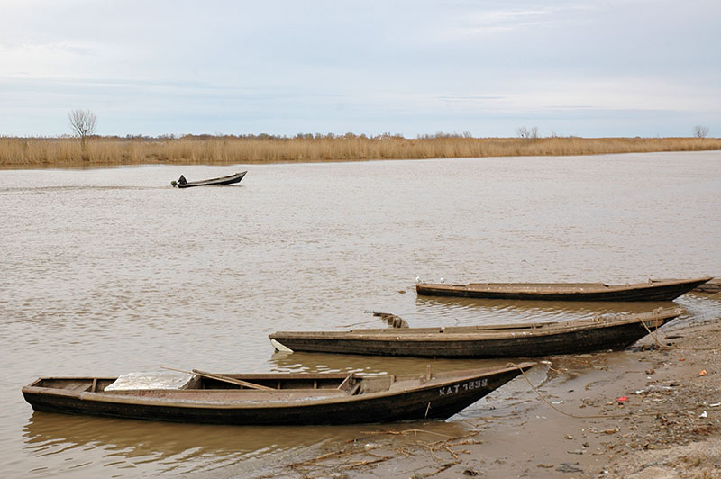
I return to Aktobe on the train and head straight out of town on the arrow-straight road east, retracing my route from last June as far as the junction town of Qarabutaq, where I turn south-east. Here the road passes through steppe marked by very occasional, distant ridges of an ancient seabed, grazed by sparse herds of Bactrians seemingly roaming totally free. After several hundred kilometres I reach the outpost town of Aral. Once a prosperous fishing port on the Aral Sea, Aral’s decline was sealed by the Aral Sea Disaster which occurred due to the huge quantities of water siphoned off the Amu Darya and Syr Darya Rivers for irrigation, the sole feeders of the endorheic Aral Sea. Starting in the late 1960s the level of the Aral Sea fell disastrously, to the point where the sea was around one hundred kilometres from the former port of Aral. I’m surprised therefore to find Aral moderately busy, with an active bazaar and plenty of people on the streets. For sure, the town has seen better days, but here is not the same kind of hopeless desperation of Moynaq, a similar former fishing settlement on what was once the southern shore of the Aral Sea, in Uzbekistan. Nevertheless, Aral’s former harbour is completely dry, the docks are a wasteland of rusting steel and broken concrete with sentinel cantilever cranes and the only boats in sight are rather poignantly hauled up onto platforms as monuments to a departed and prosperous past.

North Aral Sea, Kyzylorda Region, Kazakhstan
I drive north-west out of Aral, past the remains of an airport, turning west and dropping down onto what was once unmistakably seabed. Low hills around me still bear tide marks down their sides as sad testament to the slow death of the sea. Passing the camel-breeding village of Zhalanash I drive a few kilometres south and stop for the night in a beautifully tranquil setting on the former sea bed. Around me are the remains of three boats, once brought here alongside several others in an attempt to save them from the receding water; efforts made in vain as their long-stricken position out on this salt-dusted desert shows. Yet even these memorials to Soviet environmental callousness have not been allowed a dignified end; their long-rusted hulls and superstructures having in many cases been cut up by scrap merchants for sale to China, just leaving these three skeletons.
In the morning I continue south on sandy tracks past salt pans, hoping to return to Aral via a circular route. It is here that quite unexpectedly I see patches of reeds, and then am truly shocked to see the Aral Sea, or rather, a small northern remnant of its former self, known as the North Aral Sea. Deep blue water stretches to a horizon marked by low dry hills and while very shallow, the sea has nevertheless revived the natural environment here, evidenced by the presence of two fishermen and abundant spent shotgun cartridges lying on the ground. After the rather melancholic sights of Aral and Zhalanash, stumbling by accident upon the sea, just twelve kilometres from Aral’s long-dry harbour, is quite uplifting. There has also been reported a moderation in the harsh local climate and a reduction in the wind-borne aerosols picked up from the dry sea-bed, which are the cause of many health problems for local residents. I return to Aral on a rough track, then rejoin the main highway south-east.

Fishermen, Kokaral Dam, Kyzylorda Region, Kazakhstan
After eighty kilometres I turn off the highway once again, passing the cerulean-blue waters of Lake Qamystybas, whose scrubby shores are grazed by motley-looking Bactrian camels. I pass a couple of small towns which are surprisingly good-looking in spite of their barren surrounds, then cross the thrashing waters of the Syr Darya River at a large sluice-gate, turning north on a dirt track to the southern shore of the North Aral Sea. From here it’s a short drive to the Kokaral Dam, a low concrete dike which is the reason that the North Aral Sea has come back from the dead. I surprise the security guards who keep watch over the dam in pairs and park up on the water’s edge, where I spend two very pleasant days camping. The Kokaral Dam is built near the outflow of the Syr Darya River into the Aral Sea Basin, and prevents water from escaping to the south, into the main body of what was once the sea. Thus the North Aral Sea is reborn at the expense of the southern portion which stretches into Uzbekistan. It’s a beautiful spot, with the deep blue water contrasting against the endless khaki colour of the desolate steppe. Groups of friendly fishermen are collecting the fish stocks which have returned in economically significant quantities. It’s a very pleasant place to relax, but even more beguiling for the genuine optimism which the returning waters of the North Aral Sea have inspired in local people.
As enchanting as the reborn Aral Sea is, I have an appointment to keep and so return to the main road, continuing my way south-east towards the long-settled southern reaches of Kazakhstan. Not far upstream from the Aral Sea lies Baikonur Cosmodrome, founded by the Soviet Union in 1955, launch site of both the first satellite and the first man into space, besides many others. Both the cosmodrome to the north of the highway and the service-town of Baikonur to the south found themselves part of an independent Kazakhstan following the breakup of the Soviet Union and are now leased by Russia, closed to outsiders without an invitation to enter. However, knowing that a launch is imminent, I park up on the highway overlooking the base. Winds are strong, and I wonder if a rocket launch will really take place, but on schedule to the second I see the distant, and surprisingly noiseless sight of an unmanned Soyuz Progress rocket lift-off on its way to re-supply the International Space Station. After less than a minute of steady climbing the rocket disappears into the sparse, high strata of cloud, leaving just a white exhaust trail from the ground. A brief but unforgettable sight.
Korkut Ata Monument, Kyzylorda Region, Kazakhstan
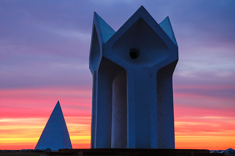
A little further along the highway, as the sun is setting, creating a dusk of vivid orange and magenta, I pull in at the shrine complex of Korkut Ata. A legendary soothsayer and bard, Korkut Ata is known throughout the Turkic world in the ancient epic Dede Korkut, which describes the ethnic history, identity, customs and value systems of nomadic Turkic people. With its roots in the pre-Islamic Turkic societies of the steppe, the epic would have been passed on orally across the steppe for generations, only being written down as late perhaps as the fifteenth century. Korkut Ata is said to hail from the Syr Darya region and, at least in the Kazakh version of the legend, was a player of the kobyz, a traditional Kazakh instrument with two horse-hair strings and a goatskin resonating cavity. The centrepiece of the beautiful modern monument complex consists of four stylised, inverted concrete kobyz, sculpted such that the wind coming off the steppe is funnelled over a group of metal tubes to emit a doleful kobyz-like sound. Combined with the glorious atmospherics, I find this a highly enchanting spot and ask the site caretaker if I can sleep here. The friendly guardian, after initial confusion is very welcoming, though insists that I stay inside his simple house just outside the complex, rather than camp nearby. This genuine hospitality, as well as the knowledge that I am at the shrine of a great Central Asian mystic, make me feel almost like an ancient pilgrim on the Silk Road.

Ancient Grave, Kyzylorda Region, Kazakhstan
Kazakhs tell that Korkut Ata was plagued by a vision of his own demise at the age of forty and took to playing the kobyz to ward-off death, only to eventually become exhausted and die of a snakebite on the banks of the Syr Darya. In the morning I walk to the edge of the great river, known as the Jaxartes to the Ancients, its muddy waters heavily depleted by irrigation upstream in Uzbekistan and Tajikistan. Here there used to be a mausoleum to the sage, washed away in the twentieth century by a flood, the site now marked by a simple modern gravestone and some scraggly saxauls tied with colourful votive prayer rags. The surrounding area is dotted with graves, buried near the great man in the Islamic tradition; some quite ancient piles of stones, others collapsing mud-brick structures as ephemeral as the lives they commemorate. The fluted brick mausoleum of Korkut Ata’s favourite consort Aksakys sits nearby, needle-like on the steppe, a faux Persian tomb tower. It is in magnificent, tranquil places like these that one feels most keenly the culture of the Kazakhs and of the steppe, far away from the often rather vapid cities.
Not far beyond the monument complex the land starts to change, from barren steppe to irrigated farmland reminiscent of Sindh or the Lower Nile Valley, which is dusty and rather bland after the pristine steppe. I make an overnight stop in the city of Kyzylorda which was briefly the capital of Soviet Kazakhstan in the 1920s, but is of no immediate interest. The irrigated agricultural towns continue for several hours beyond Kyzylorda until the land abruptly reverts to virgin steppe; it is at about this point that I am funnelled into a natural corridor between the Syr Darya to the south and the Karatau Mountains to the north. This natural trade route marks roughly my re-entry to the historical heartland of Transoxiana (western Central Asia) with its maudlin remnants of a world-changing past.

Sauran, South Kazakhstan Region, Kazakhstan
Before long, to my right appear the mud-brick walls of the great city of Sauran, lying silent a few kilometres away in the steppe. Sauran controlled the very trade route which I am currently driving along and was an outpost at the edge of settled civilisation, surrounded by seven towering city walls and served by a Persian karez type of underground irrigation system. First mentioned in the tenth century, Sauran was invaded by Chinggis Khan (Genghis Khan) and later became the capital of the White Horde under one of his grandsons. Timur (Tamerlane) took over the city in the fourteenth century, turning it into a fortress. However, as the nearby city of Yasi (Turkistan) grew in importance, Sauran’s prosperity waned and it was permanently abandoned in the nineteenth century. Today, Sauran’s heavily eroded walls, which hover on the grassy steppe, are perhaps Kazakhstan’s most evocative sight, speaking of the decay of Central Asia in the same way as the ruins of Balkh or Merv; of transient splendour slowly washing back into the earth. I have the entire city to myself and explore the remains of the thick perimeter walls, in places up to seven metres high and heavily eroded, walking among excavated tiles and stumps of walls, over ground still strewn with pottery shards, a ghost of thousands of lives lived, now forsaken by the outside world.
I stop the next morning in Turkistan, home to the shrine of the twelfth century Sufi mystic Khoja Akhmet Yassawi and one of the most magnificent pieces of Timurid architecture, at the sight of which I was rapt during my first visit in 2007, close to the beginning of the Odyssey. Seeing the glowing faïence of the shrine’s gorgeously fluted dome at the end of a torrid July day was one of my most formative experiences of Central Asia. I don’t wish to overwrite my initial memories however, so after a brief re-acquaintance with the site, I move on. Not far beyond Turkistan I turn south off the highway, towards the confluence of the Arys and Syr Darya Rivers, where lies the Otrar Oasis.

Otrartobe, South Kazakhstan Region, Kazakhstan
If Sauran is a romantic ruin of the past, then Otrar stands as a testament to a bitter lesson in history. Lying at a node of Eurasian trade routes, on the border between settled and nomadic civilisations, the Otrar Oasis has been settled since at least the sixth century, and in the past consisted of a number of individual settlements. Known before the thirteenth century as Farab, Otrar would have been a centre of Turkic culture and it is considered by many to be the birthplace of Al Farabi (Alpharabius), one of the greatest medieval polymaths and poets. In 1218, Otrar’s ruler, Khorezmshah Mohammed II, received news of an trade envoy sent from Chinggis Khan, a man he refused to treat as an equal, and sorely underestimated. He sent his governor Inalchuk out to rob, then arrest the leader of the envoy, who was finally put to death. This was to prove a fateful moment in history; for it was the following year that Chinggis Khan unleashed the fury of the Mongols upon Central Asia, later reaching as far as Arabia and Eastern Europe. After a five month siege, the oasis was razed to the ground and all its citizens slaughtered. Otrar was to recover in parts, until its final demise in the late eighteenth century, but never to its earlier extent. Otrartobe, the main archaeological site of the oasis, is now a vast pile of the detritus of civilisation, its collapsed earthen walls glinting with the white of broken bones and blue ceramic fragments.

Steppe, near Shardara, South Kazakhstan Region, Kazakhstan
South of Otrar I cross to the left bank of the Syr Darya and follow the river upstream on a road which soon looks as if had also been left to decay since the thirteenth century. These are the fringes of the Kyzyl Kum Desert, a desolate landscape dotted by occasional, desperate-looking fly-blown settlements. In places the track is so faint as to be hard to discern against the steppe, but before too long asphalt returns and I’m driving through a green, irrigated area towards the southernmost point of Kazakhstan. Reaching the large Shardara Reservoir, I cross the river again and drive east across beautiful, rolling green grasslands dotted with shepherds on horseback tending flocks of sheep, quite unexpected given the proximity of the desert. My destination is the small, modern cotton-processing town of Zhetisay, located in a salient of Kazakhstani territory surrounded on all sides by Uzbekistan. Zhetisay is a dull country town, but I have the good company of my host Katherine, a Peace Corps volunteers, and her affable Russian landlord Yura, who is only too pleased to help me finally fit the new front springs onto the truck, which I’ve been carrying for more than two months since leaving Estonia.

Bazaar, Shymkent, South Kazakhstan Region, Kazakhstan
I stay a few days in Zhetisay where the summer heat is already building before resuming my eastward journey, tracking the border with Uzbekistan past the chaotic border crossing which I used almost four years ago, named rather romantically ‘Zhibek Zholu‘, or simply ‘Silk Road’. I stop in Shymkent, a slightly gritty, industrial city and the largest in southern Kazakhstan, where I am hosted by Kanat, a self-made businessman who spends his days checking up on various concerns of his and has built a large house for his extended family, acting as the head of the house in place of a father. I share a room with Kanat’s nineteen year-old brother who has recently decided to become a pious Muslim, though seems to be having trouble waking up in time for the dawn prayer. Kanat is openly disapproving of his brother’s newly found faith, dismissing it as something of a fad; an opinion I would often hear from older generations in Kazakhstan concerning the visible increase in religious posturing of the country’s youth.
Shymkent was founded in the twelfth century in the shadow of nearby Sayram and became a trading post between Turkic nomads and settled Sogdians. Aside from its heavily polluting lead smelters, modern Shymkent remains a bustling market city, more of a metropolis than most of the country’s provincial capitals, but it lacks singularly any visible evidence of its long history. It is still however a city based around trade and its bazaar is one of the biggest in the country with a range of goods from the farmland to the south and pastures to the north, and a range of faces reflecting both settled and nomadic ancestries.
Sayram, less than twenty kilometres from the centre of Shymkent is perhaps the oldest surviving city in Kazakhstan and one of the oldest in Central Asia; a relaxed country town populated almost entirely by ethnic Uzbeks and free from any Soviet urban architecture. As might be expected in such a long-settled place, Sayram is full of cemeteries and mausolea, including those of the mother and father of Yassawi (who was born here), drawing a steady trail of pilgrims. I’m not quite sure what to make of Sayram however; at once it’s a tranquil rural town with far more character than most of Kazakhstan’s settlements, whilst simultaneously being very obviously a shadow of its former self and lacking any particular focus. After visiting the visually unremarkable mausolea, I content myself with a brief wander along winding lanes, then head south towards the green mountains.

Tulipa greigii, Sayram-Ugam National Park, South Kazakhstan Region, Kazakhstan
It’s not far from Sayram to the small town of Lenger, which though rather nondescript, is in an appealing setting of rolling green hills, backed by the snowcapped Ugam Mountains to the south; quite unlike anywhere I have been in the last few weeks. I’m hosted here by Serik in his spacious family home, where he lives with his wife and son. Serik is not part of the urban business class, or an employee of a multinational, but he has single-handedly taught himself English and through his generosity in opening his home to travellers, gives me a touching insight into rural life, a pleasant change from staying in the generally bland cities.
The following day I drive out of Lenger into the hills, reaching a road-head in the recently-established Sayram-Ugam National Park, where I leave the truck and strike out on foot. An outlier of the Western Tien Shan, here forming the border with Uzbekistan to the south, the slopes of the Ugam Mountains are a gorgeous carpet of emerald green grass, still filled with snow in creases and gulleys and dotted with dark green dwarf pines. I walk for a few strenuous hours up into the mountains, reaching a broad saddle still covered in deep winter snow, with magnificent views west across buckling foothills which soften into flat steppe in the far distance.
Just as enchanting as the views is the native flora; from wild apple-blossoms in the valley floors, to a beautiful range of wild tulips which dot the mountainsides. Some, such as Tulipa kaufmanniana have bright yellow, elongated petals and look quite unlike commercial European varieties, whereas others such as the beautiful Tulipa greigii have the iconic bulbous flower-head which caused so-called ‘Tulip Mania’ in seventeenth century Holland. It is however here, in these flower-dotted grassy hillsides of the Tien Shan that the tulip originates.

Kazakh Man, Taraz, Jambyl Region, Kazakhstan
It’s two hundred kilometres to my next stop; the city if Taraz, founded two thousands years ago, devastated by the Mongols in the thirteenth century, only returning to prominence in the early nineteenth century when re-settled by the Khanate of Kokand, and taken by the Russians not long after. Taraz has a nicer atmosphere than Shymkent and is also a bustling market city, as it was in ancient times. With a pair of restored Karakhanid mausolea, and extensive archaeological remains of the pre-Mongol city preserved in the modern centre, there is for once a palpable air of longevity about the place. Previously known as Talas (after the nearby river), from where its current name obviously derives, Taraz is perhaps most noteworthy for being the approximate site of the 751 CE Battle of Talas, in which the armies of Tang Dynasty China was routed by the Arabs (allied with Tibetans), thus keeping Chinese influence out of Transoxiana and establishing Islam as the dominant cultural force. In addition to the immediate, regional impact of the defeat, wider reaching effects included the wane of Buddhism in Central Asia, isolating it from its Indian base and fostering the development of the current, Mahayana schools of northern and eastern Asia, and the import of paper-making to the Middle East, from where it later spread to Europe.
One of the conditions of my two-month long Kazakhstan visa requires me to leave the country within thirty days, and re-enter in order to continue my stay. Thus after two days I leave Kazakhstan from the border crossing with Kyrgyzstan which lies just beyond the outskirts of Taraz, where indeed the great battle may well have taken place. As a result of a recent joint agreement between the two countries, I am able to enter Kyrgyzstan with my visa for Kazakhstan, though the suspicious Kyrgyz border guard seems never to have heard of it and I’m only stamped into the country after calls are made to superiors.

Suusamyr Valley, Chuy Region, Kyrgyzstan
Kyrgyzstan is noticeably quieter than Kazakhstan and the landscape immediately becomes more mountainous. I pass the Kirov Reservoir, where a giant face of Lenin has been cast in concrete onto the mountainside, and begin climbing in an easterly direction up the valley of the Talas River. At first the landscape is agrarian, the road lined by small farming communities, but shortly after passing the small, modern provincial capital of Talas, I enter the high, rolling grasslands as the road winds up towards the snowcapped peaks of the Tien Shan. Crossing the 3300-metre Ötmök Pass, I drop down onto the M41 Highway which runs south through the Pamirs to the Amu Darya and Afghan border; surely one of the world’s most beautiful roads. I turn north however, back towards Kazakhstan and descend slowly into the utterly glorious Suusamyr Valley, a broad, grassy plain dotted with Kyrgyz yurts and backed in the east by the gorgeous, smoothly snowcapped peaks of the Tien Shan. I had driven this road almost four years earlier in August 2007, but seeing it now with the grass greener and the snow thicker, it seems even more enchanting than before.
The Suusamyr Valley section of the M41 ends with a steep climb to the 3180-metre Töö Ashuu Tunnel, bored three and a half kilometres through a mountain, then descends steadily to the Chuy Valley. It’s late in the evening before I reach Bishkek, where I turn north to the busy border with Kazakhstan at Korday. Here, after several hours of delays and searches by official most likely waiting for a bribe, I am stamped back out of Kyrgyzstan, concluding my sixteen hour visit. Ahead of me awaits three more weeks of travel on the huge Kazakh Steppe.
