
Stage 29 – Kyrgyzstan, Tajikistan, Uzbekistan & Kazakhstan: Transoxiana [1/2]

Transoxiana, literally meaning ‘Land beyond the Oxus’ is a swathe of long-settled territory at the heart of Central Asia, stretching from the Pamirs in the east to the Aral Sea in the west. It was this region which had initially drawn me towards Asia instead of Africa, and it was the first which I had explored in any real detail, on the outward leg of the trip more than four years earlier. For this reason I felt particularly attached to these fascinating and colourful cities and landscapes, and found myself on several occasions feeling quite nostalgic, considering all that I had learned and experienced in the intervening years of continuous travel, looking back on a journey of more than 120,000 kilometres around the continent. Perhaps it was rather ironic, or perhaps quite logical, that it was here that I finally decided to conclude the trip. I had plenty of money remaining, the truck was still in fairly good condition and I was still fit and healthy, but I had almost run out of places to visit, and my seemingly endless curiosity was finally being (temporarily) sated. The thought of returning to the dull mundanity of Western Europe, after years of exhilarating freedom held no appeal whatsoever, but it seemed a logical choice. So, as I toured the backroads of Transoxiana which I had missed in 2007, in the sweltering summer heat, I was both physically and mentally beginning a return journey, to somewhere I could scarcely call home. Far from being melancholic however, this five thousand kilometre journey from the Tien Shan Mountains, down through the lowlands and jigsaw-borders of the Fergana Valley, through the barren wastes of the Kyzyl Kum Desert and on to the Caspian Sea, would give me one last, lingering view of the Kyrgyz, Tajik, Uzbek, Russian and Kazakh societies of modern-day Transoxiana.

Ala Too Square, Bishkek, Kyrgyzstan
On the 8th June 2007 I enter Kyrgyzstan from Kazakhstan at the cross-border town of Korday, and head straight to Bishkek. The Kyrgyz capital was where I had made my first real rest stop of the trip, and now, years later I would repeat this. Modern Bishkek was established as a Russian garrison in 1865 and is certainly not one of the region’s great historical cities, but it makes for a pleasant place to relax. Despite last year’s revolution, which unlike the ‘Tulip Revolution’ of 2005 descended briefly into violence and anarchy, the city seems not to have changed and retains, by day at least, a pleasant and friendly atmosphere. Tree-lined avenues separate long urban parks and are filled with pretty girls and street food stalls giving a strong hint of Asia; unsurprising given that China is just a few hour’s drive away. In slight contrast to this free market atmosphere stand some polished examples of Soviet architecture, such as the genuinely impressive Parliament Building, or the 1980s modernist National (formerly Lenin) Museum. All streets slope gently upwards towards the magnificent mountainous backdrop in the south, a reminder that one is close to the heart of the ruggedly beautiful Tien Shan Mountains. A touch faded, and shabby at the edges, Bishkek is something like a poor, country cousin of Almaty, though far less pretentious and no less pleasant to spend time in; something I do thanks to the hospitality of a Simon, an ebullient Frenchman who works for an environmental NGO.
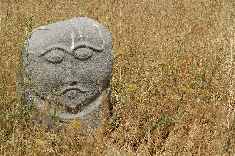
Balbal, Balasagun, Chuy Region, Kyrgyzstan
Leaving the comforts of Simon’s downtown apartment after two-and-a-half weeks, I leave the city, following the Chu River upstream towards Issyk Kul, stopping off at the village of Balasagun. Originally a Sogdian city, then one of the capitals of the Kara-Khanid Khanate, a pre-Mongol, Turkic tribal chiefdom, the scant remainder of the city, which consists of just a lone, truncated and heavily restored red-brick minaret, is one of very few pieces of historical architecture in Kyrgyzstan. Balasagun was, like so many others, attacked by the Mongols, after which it fades from history. Much more interesting however is a collection of balbals, anthropomorphic stone stelae which were carved as some sort of tribute to the dead by a succession of steppe cultures of Central Asia, Siberia and Eastern Europe. Here, the balbals have been rescued from around the country, and make up a fantastic array of different humanoid proportions, with different qualities of posture and expression.
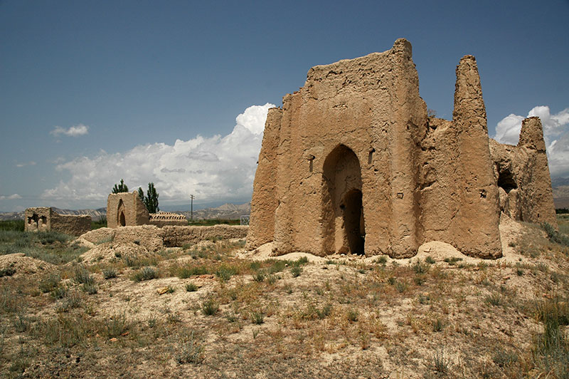
Taylik Batyr Mausoleum, Ak-Tal, Naryn Region, Kyrgyzstan
From Balasagun I continue east, turning off the highway just short of the toll gates at Balykchy, where a swingeing toll charge is extracted from foreign motorists; instead crossing on gravel tracks through a mine to emerge on the lumpy highway which heads through the centre of the country on its way to the Chinese border. As dusk approaches I turn west onto a dirt track and wind up and over a 3450-metre pass as darkness falls and a dramatic thunderstorm breaks, dropping down to the shores of Song Kul, a magnificently beautiful, jewel-blue lake at the very centre of the country. In the morning light the views are immense; of the even bowl of yellow-green grass which sits, ringed by mountains and dotted with distant white yurts and herders on horseback corralling sheep and horses. Memories of the days spent here in 2007 with Oliver come flooding back as I drive towards the south-western edge of the bowl, climbing briefly to a ridge where the land falls away to the south in a dramatic, cloud-filled canyon, its steep and inaccessible sides still dotted with dark conifers. The track descends this spectacular chasm in nine long, vertiginous switchbacks which drop seven hundred metres into the canyon floor, then descends further to parallel a river, which brings me to an area dotted with crumbling mud-brick mausolea. Like the Kazakhs to the north, the Kyrgyz are are traditionally nomads and mausolea such as these are the only lasting mark they leave on the landscape. Here however, I am slightly surprised to find mausolea somewhat more elaborate than those which dot the Kazakh Steppe; often built in the form of a small citadel, with corner towers, crenelated walls, domes and basic Islamic ornamentation picked out in the brickwork.

Fergana Mountains, Jalalabad Region, Kyrgyzstan
Just beyond the mausolea, the track crosses the Naryn River and turns east again, winding slowly over another mountain pass into sparsely populated country of badlands and irrigated fields, through the bleak and unloved mining town of Kazarman, then slowly ascending over hills of powdery loess covered in a thin, velvety carpet of grass. As the grassy ridges start to gather into mountains, the track begins the steep and at times rough climb up the 3000-metre Kaldama Pass over the Fergana Mountains, whose western slopes are covered in lush, tall grass and shrubs. In the late afternoon, the sun is just descending over the snowcapped peaks to the north-west, picking out sharp ridges of emerald-green in a spectacular mountain vista. Stretching away below me into the haze to the south-west lies the region at the very heart of Transoxiana; the Fergana Valley.
More than two-and-a-half millennia of history are contained within this broad, mountain-ringed lowland at the western edge of the Tien Shan, where the Naryn and Kara Darya Rivers join to form the Syr Darya. It was along this river that Herodotus’ knowledge of the world ended; the edge of civilisation. It was here that Alexander the Great established his most far-flung city, and where the Chinese first encountered the Indo-European civilisations to west, establishing the Silk Road in the first century BCE, and later making Fergana a centre for silk production in a tradition which endures today. This was the stomping ground of Genghis (Chinggis) Khan and Timur (Tamerlane) and Fergana’s most famous scion, Babur, patron of Kabul, who went on to found the Mogul Empire in India.

Kara-Khanid Minaret, Uzgen, Osh Region, Kyrgyzstan
I descend into the sweltering Fergana Valley the next morning, stopping briefly in the uninteresting city of Jalalabad, where I join the M41 Highway and continue south to the smaller town of Uzgen. Like Balasagun, Uzgen was for a period a capital of the Kara-Khanid Khanate, which lasted from 999 to 1218, and it is here that I find Kyrgyzstan’s greatest architectural ensemble. Next to the Kara Darya River sit three fine, conjoined, red-brick mausolea, one of which features an exquisite frieze of terracotta inlay around its arched entrance portal, said to be the precursor of the dazzling turquoise and lapis-tiled mausoleum complex of Shah-i Zindah in Samarkand. Next to the mausolea is an eleventh century minaret in the same red-brick, finer and taller than that at Balasagun with attractive, alternating bands of geometric brickwork. These buildings are some of the few architectural remnants of the Kara-Khanids; a dynasty who oversaw an important cultural syncretism during which Transoxiana becoming linguistically Turkic, but when simultaneously its Turkic inhabitants became more influenced and assimilated into settled, Persian and Arabian-Islamic culture. The Kara-Khanids were eventually weakened successively by the Seljuks, Kara-Khitans and Khorezmians, until the Mongols came in 1218 and swept away all that had preceded them. Nevertheless, the Kara-Khanids left an important cultural legacy, which can still be felt today.
Transoxiana was incorporated into the Russian Empire in the late nineteenth century, and following the Bolshevik Revolution, the region became subject to Stalin’s hand when, as Commissar of Nationalities, he was responsible for drawing borders to delimit the titular republics of the Fergana Valley’s Uzbek, Tajik and Kyrgyz inhabitants. What resulted was a hideous jigsaw of meandering boundaries and enclaves which paid no regard to topography, infrastructure or indeed ethnic considerations. Whether this was simply a botched attempt, conducted with the contempt for common sense beloved by totalitarian bureaucrats, at an admittedly difficult task; namely to segregate the inherently mixed inhabitants of the Fergana Valley, or, as in the case of the British drawing up the boundaries of the Middle East, a deliberate construct to foster ethnic strife and failure of nation states, is unknown. However, following independence in 1991, the Fergana Valley was divided between three sovereign states, whose absurdly impractical borders, coupled with mutual mistrust has seriously hampered regional economic development.
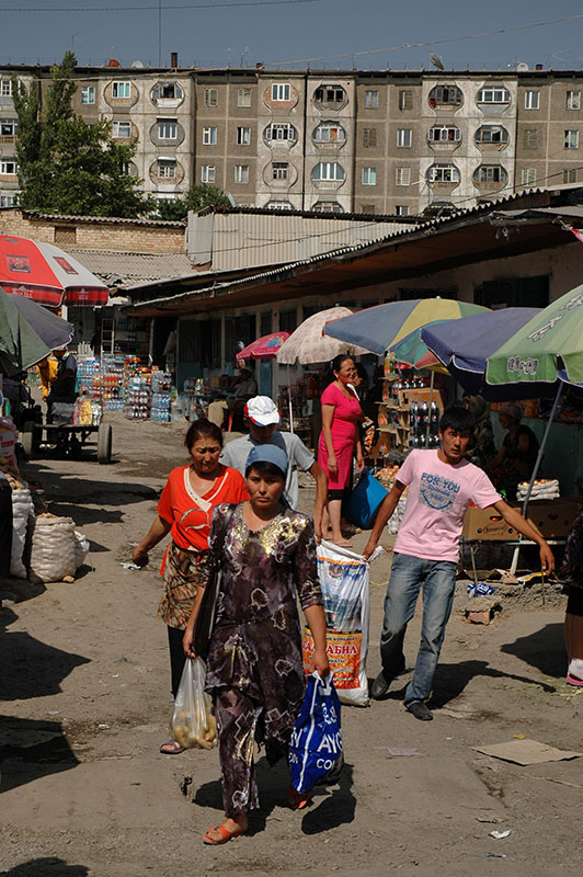
Bazaar, Osh, Kyrgyzstan
Perhaps worse than the impractical national borders however, is the legacy of the Soviet Union’s divide-and-rule policy, which saw all the region’s settled Turks labelled as Uzbeks, and all nomads and herders labelled Kyrgyz, leading to the Fergana Valley becoming an Uzbek ‘heartland’. Following the Soviet Union’s progression into economic stagnation under Brezhnev, Gorbachev’s perestroika (economic reforms) favoured liberalisation of trade, which benefited the settled, trading Uzbek population of the Fergana Valley far more than the Kyrgyz, who were typically herders. At the same time, Uzbeks were (and still are) severely under-represented in Kyrgyzstan’s government. A dispute over the division of land from a state collective farm was the spark which, as in so many other parts of the Soviet Union in its dying days, ignited ugly inter-ethnic violence and riots in the summer of 1990, which left a figure of between several hundred and a thousand people dead in the cities of Osh, Uzgen and Jalalabad. The riots recurred last year in Kyrgyzstan’s portion of the Fergana Valley, when civil order broke down during the 2010 Revolution resulting in perhaps two thousand people, mostly Uzbeks, being killed and up to one hundred thousand fleeing into Uzbekistan.
It was with this as a backdrop that I made my first visit to Osh, Kyrgyzstan’s second city, a very ancient settlement poised between nomadic and settled worlds, a city which grew with the ancient Silk Road and is still renowned today for having one of the largest bazaars in Central Asia. Babur described Osh with fondness, though I find little reason to favour it. My first impressions are of a city with strong, almost South Asian squalor; chaotic traffic, stalls encroaching onto the streets, taxis stopped at the roadside obstructing traffic, pedestrians walking without regard to traffic, roadside gulleys stinking of sewage-tainted stagnant water, filled with decomposing rubbish and plastic garbage (here mostly beer bottles) and feral street children in tattered clothes holding their hands out hopefully to passers-by. Everywhere is broken, crumbling concrete, peeling paint and plaster, wild flowerbeds and lawns, and parks gone to seed, amidst some semblance of old Soviet order in the ranks of grey, ill-maintained apartment blocks and other architectural remnants of this epoch which sit rather awkwardly amongst the chaos. The city must have been far nicer in Soviet times.

Rooftops, Osh, Kyrgyzstan
I check into a flophouse popular with backpackers near the city centre, run by a Kyrgyz who wears flowing Islamic garb and a long beard, but who has a rather false air of piety about him. On the communal noticeboard is a doleful, recent message of warning from a Belgian male tourist, who was out alone in the city at night and beaten-up by a group of locals. Out on the streets, the evidence of last year’s orgy of ethnic hatred is still abundant, with burnt-out buildings in the area around Osh’s dirty and frankly disappointing bazaar. It’s slightly chilling to think that some of the Kyrgyz of the city so eagerly slaughtered their Uzbek neighbours just a year earlier. In comparison to Jalalabad and Uzgen, I see few obviously Uzbek faces here, and the atmosphere is more tense. Groups of young, cocksure Kyrgyz adolescents roam the streets and I fancy that I detect a slight hint of barbarian gloating on their faces. Perhaps I am inflating things somewhat in my mind, but it is a long time since I have come across a place of this size which has such a raw and lawless atmosphere. I don’t venture far after dark, and ensure that the car is in a locked, secure parking lot.
Osh’s only real attraction is the striking, barren hill which rises above the dusty plains immediately to the west of the city, known as Suleyman Mountain, for legend has it that the Islamic prophet Suleyman (Solomon) was buried here. For millennia the mountain has been considered holy, and together with James, a very intelligent, affable and well-travelled British Army Officer who I meet in town, ascend the ancient rock-cut steps up the mountainside. On the summit are the familiar signs of pagan-influenced Central Asian Islam, with colourful votive prayer rags tied to tree branches and local women crawling through an opening over a holy rock in hope of giving birth to healthy offspring. Babur is said to have built a small mosque on the summit, though what remains today is rather plain and modern. The cooling breeze and views in the lengthening evening light are wonderful however, giving a beautiful view over the edges of Osh, which fade away in a rabble of disorderly, pitched-roof houses and mulberry trees into a dusty horizon, a typical and rather timeless Fergana scene which Babur might have recognised.

Turkestan Range, near Korgon, Batken Region, Kyrgyzstan
Beyond Osh, the road takes me to the far west of Kyrgyzstan, along the southern margin of the Fergana Valley, here delineated by the Turkestan Range, part of the greater Alay Mountains which drop down to the west from the central Pamir Knot in eastern Tajikistan. Leaving the environs of Osh, the country soon reverts to gentle, rural lassitude, and as I push further west, the settlements become increasingly sparse. It is here that Stalin’s irrational gerrymandering of the borders of the three republics reaches its zenith, and the road on which I am driving must negotiate around the meandering Uzbekistani border, passing the the exclave of Shakhimardan, then making a long detour around the exclave of Sokh. The landscape becomes increasingly pretty, a classical scene of lowland, rural Central Asia, with irrigated villages nestling between barren low hills, a swathe of green fields and streets lined by dry stone walls and tall poplars. I stop in the early evening in the provincial capital of Batken, which is little more than a large village, the result of the creation of Batken Region in 1999 to increase security and law enforcement in this far-flung arm of the country, in face of a threat of Islamic extremism and drug trafficking crossing the mountains from Tajikistan in the south.

Road to Isfana, Batken Region, Kyrgyzstan
Batken has a far more pleasant and tranquil atmosphere than Osh and I enjoy a good laghman (Central Asian noodle soup) in an outdoor chaikhana (tea house) under what is perhaps the largest apricot tree I have ever seen. The Kyrgyz here seem a touch softer and more refined than their up-country cousins, mellowed perhaps by settled life in such a splendidly fertile valley. Beyond Batken the road climbs, and the scenery becomes spectacular, with glimpses of snowcapped mountains. I pass the Tajikistani exclave of Vorukh, a mountainous redoubt accessible only by a single cleft in the surrounding wall of rock, then climb steadily to the west through a mountain paradise of green villages fed by crystal clear mountains streams, reminding me of the Hindukush of Pakistan and Afghanistan. Finally, the road drops down back into the Fergana Valley, to the slightly shabby town of Isfana, at the very far end of Kyrgyzstan, where I stop for another night. The following morning I follow the road out of town which roughly parallels the jagged border with Tajikistan through sleepy, forgotten kolkhozes (collective farms). At times I am genuinely unsure which country I am in, but after one false turn, I make it to the town of Kulundu and cross into Tajikistan. As per my first visit to the country, I leave Kyrgyzstan with rather mixed feelings; a country which seems to lack much spirit of nation building or ethnic identity, though is a mostly pleasant and laid back place to visit. Stunningly beautiful in parts, yet depressing, squalid and even rather hostile in others, Kyrgyzstan is not a country which I feel any great sadness in leaving.

Syr Darya River, Khujand, Sughd Region, Tajikistan
Both sides of the border crossing are friendly and painless, though the guards are unused to seeing a foreign vehicle. On the Tajikistani side, where the immigration and customs buildings are part of the main street in the small town of Ovchi-Kalacha, Boburjan, one of the Tajik immigration officials learns of my interest in Asian history and points to a defile in the distant, rust-coloured mountains which lie to the north, beyond the city of Khujand. He tells me that it was from that the armies of Chinggis Khan arrived and laid siege to the city, until certain of its traitorous populace opened the city gates and allowed the great Khan to enter, only to immediately be dispatched for their treachery. To this day, despite a period of almost eight hundred years having passed, and despite the destruction he wrought, the legend of Chinggis Khan is massive in Asia, and he seems to be universally respected.
It’s a short drive to Khujand, Tajikistan’s second city and western gateway to the Fergana Valley. Attractively positioned astride the gleaming turquoise waters of the Syr Darya, Khujand is an ancient city, which might either have been founded as Cyropolis, the city of the Persian empire-builder Cyrus II (Cyrus the Great) on his expedition against the Saka, on the very edge of his empire, or as Alexandria Eschate or ‘Alexandria The Furthermost’ by Alexander the Great, as the most far-flung of his Macedonian settlements. Modern Khujand does not quite live up to such romantic, edge-of-the-world notions, but is nevertheless a very pleasant place, noticeably more refined than the cities of Kazakhstan and Kyrgyzstan through which I have been travelling for the past few months. I enter the city on a visually striking six lane Soviet triumphal avenue, with immaculate flowerbeds in the central reservation, lovingly irrigated in the forty degree summer heat. This is however a neat trick; a Potemkin facade that post-Soviet autocrats like to put on to impress visitors and natives alike. A quick look beyond the polish however soon reveals considerable poverty in Khujand, and this sleek avenue is where the civic spending seems to end. Indeed Khujand, which might be thought of as the country’s cultural and intellectual capital, lost its power during Tajikistan’s bitter civil war of the 1990s and remains opposed to the current regime, which naturally marginalises the city, and the province of Sughd (named for the earlier Sogdian Empire) of which it is the capital.

Uzbek Clothseller, Khujand, Sughd Region, Tajikistan
Khujand is a lively market town and activity, as in much of Asia, revolves around the city’s central Panjshanbe (Thursday) Bazaar, which is a marvellous edifice of bright, pastel Stalinist architecture with colourful touches of Qajar-era Persia. Inside is a kaleidoscope of faces; Persian, Aryan, Turkic, Mongol and Gypsy, reflecting the full spectrum of Transoxianian humanity. After weeks of guttural Turkic, it’s also pleasing to hear the soft tones of Persian, albeit with the strange Tajik accent, and people here seem far gentler and more culturally secure than their historically nomadic neighbours to the north. I spend my days in the city slowly making my way round the bazaar, the scant remains of the ancient nearby citadel, and along the river banks, frequently stopping in chaikhanas to drink hot green tea, to fend off dehydration from the terrible heat.
My personal highlight in the city is my host Javohir, who graciously accommodates me in his apartment, where he lives with his wife and two young sons. I get on immediately with Javohir, who is educated and intelligent, fluent in English and has experience of living abroad, yet who lacks the connections required in this country to secure well-paid employment and exists on a very meagre salary, with which he struggles to support his family. Javohir is a Tajik, and a Muslim, but a man who is less concerned with petty ritual than with the true social message of his faith. We spend afternoons swimming in the warm, clear waters of the Syr Darya with his kids, and have long discussions into the night, bemoaning the corrupt and useless government which does nothing for common folk, and discussing the state of the greater outside world.

Dome Of Abdul Latif Medressa, Istaravshan, Sughd Region, Tajikistan
I make a side trip into the hills to the south of Khujand, to the provincial town of Istaravshan, which takes me slightly by surprise, for it is perhaps the nicest town I have seen in the country. Like Khujand, Istaravshan has a long history, and legend has it that it was near here that Alexander won his bride Roxanne by conquering the seemingly impenetrable citadel of a local ruler. Beyond a rather drab modern city, Istaravshan has a marvellous Old Town with wonderful, winding kuchei (alleys) with central, open sewer troughs, and traditional Central Asian family houses whose open gates and doorways reveal large walled courtyards with fruit and vegetable plantations. The people here are a real highlight; some of the friendliest and most welcoming whom I have met in the region, and I receive numerous invitations to tea, or to just to come inside and view their beautiful houses, some of which have century-old, colourfully painted wooden interior beams and columns. It’s a real treat to walk the backstreets and encounter people who seem genuinely interested to meet a foreigner.

Tajik Mullah, Istaravshan, Sughd Region, Tajikistan
Aside from the wandering lanes and rural ambience of the Old Town, Istaravshan has some specific points of interest. There are fine, Bukharan-style open-fronted mosques with carved wooden pillars, and the beautifully tranquil Sar-i Mazar ensemble, set amongst pools of open water and huge six- and eight hundred year old chinar (plane) trees. Two separate mausolea, their portals covered in tile mosaics and whitewashed stucco cover the main graves, in addition to a fine open-fronted mosque with the peculiar, colourfully painted ceiling beams which seem to be characteristic of the region. People are curious to see me, and take the time to show me specific details, and explain a little about them. The town’s jewel however is the Abdul Latif Medressa with its magnificent Timurid kok gumbaz (blue dome) of turquoise and lapis, every bit as fine as the domes of Samarkand or Bukhara, if slightly more restrained. Inside the buff brick of the medressa (seminary), a class of young boys study the scriptures on this peaceful Sunday afternoon, making the building all the more alluring for not being simply a polished but lifeless museum-piece. I later make my way back back to Khujand in the cooling evening, feeling quite serene and rather impressed with Tajikistan as a country.
After three thoroughly enjoyable days in northern Tajikistan, I drive east again out of town, past the turquoise water of the Kairokum Reservoir, towards the centre of the Fergana Valley. Once again however, a national boundary blocks my path, and I arrive mid-morning at the far end of the sprawling market town of Konibodom, where the road reaches the border crossing into Uzbekistan. Relations between the two countries are highly volatile, and cross-border traffic is a mere trickle, another example of Stalin’s foul legacy in Central Asia. Formalities on the Tajikistani side are fairly brief, though not without an (unsuccessful) request for a bribe, but I am met by a locked gate when reaching the Uzbekistani customs post. Here I am eventually let in, the only traveller save for an old Uzbek lady. The Uzbek border staff are very friendly and welcoming however, and intrigued to see a foreign vehicle crossing at this nearly deserted post. Unusually for Uzbekistan, where customs officers typically all but take apart vehicles in search of narcotics, not so much as a glance is made inside the truck.

Friday Mosque, Kokand, Fergana Region, Uzbekistan
It’s shortly after mid-day by the time I’m through the border, and drive to the city of Kokand in the sweltering heat. Soon after arriving, I set about acquiring one hundred US Dollar’s worth of Uzbekistan’s farcical currency, the Som; a transaction which is best carried out on the black market, in a country with a serious cash shortage and where ATMs are almost useless. A friendly bread seller whom I ask about this slightly shady deal immediately leaves his business and walks me down to the roguish street money-changers, making sure I am not ripped off, with no intention of personal reward. I acquire 246,000 Uzbek Som in 1000 Som notes, which approach the size of a small loaf of bread. Compared to Tajikistan however, I see immediately that Uzbekistan, despite its crippled monetary economy (run by a President who claims to have an education as an economist) is comparatively quite advanced; Kokand looks prosperous and organised, with better roads and traffic consisting almost entirely of new-looking, locally made cars. It’s also a reminder that, although Kazakhstan is certainly the economic leader in today’s Central Asia, in Soviet times this title very much went to Uzbekistan.
Kokand lies at the heart of the Fergana Valley and has a long history as a trading centre on the Silk Road. It is most famous however as the former capital of the Khanate of Kokand, an Shaybanid Uzbek tribal chiefdom which was an offshoot of the Khanate of Bukhara, established in 1709. The Khanate of Kokand, under the ruthless leadership of Alim Beg came to dominate the Fergana Valley in the early eighteenth century, becoming a pawn in the Great Game, a period when Imperial Russia and Imperial Britain vied for dominance in Transoxiana, with Russia eventually taking the last Kokand Khan’s territorial possessions and sending him into exile. The last Khan’s palace still stands today, a rather gaudy and crassly restored edifice which well defines the excesses of Asian wastrel leaders through the ages. More restrained attractions in town include a sprawling necropolis in which I spend an hour or so looking at the various graves and mausolea, and the beautiful nineteenth century Friday Mosque, with a simple, tapering, turquoise-domed, free-standing minaret set on a beautiful green lawn dotted with tall chinars and surrounded on four sides by open prayer galleries.
With this brief re-introduction to Uzbekistan complete, I head for the mountains to the north-west, leaving the Fergana Valley and making the long climb up to the Kamchik Tunnel which, at 2150-metres above sea level, links the Fergana Valley to the rest of Uzbekistan. I drop down through the sprawling towns of Angren and Almalyk as darkness falls, heading north east to what is undoubtedly my favourite city in the region: Tashkent.

Excellent reading material…..Takes you there.