
Stage 29 – Kyrgyzstan, Tajikistan, Uzbekistan & Kazakhstan: Transoxiana [2/2]
I arrive in Tashkent on the evening of the 4th July 2011, coming off the main road from the Fergana Valley, straight into the district of Lisunova. As in my three previous visits to Tashkent, I stay here in the vacant apartment owned by the family of Pasha, a Russian friend of mine from Novosibirsk whose family lived here until 1997. I am greeted by their former neighbour Gulya, who despite the late hour welcomes me with tea and cakes, as an old family friend.

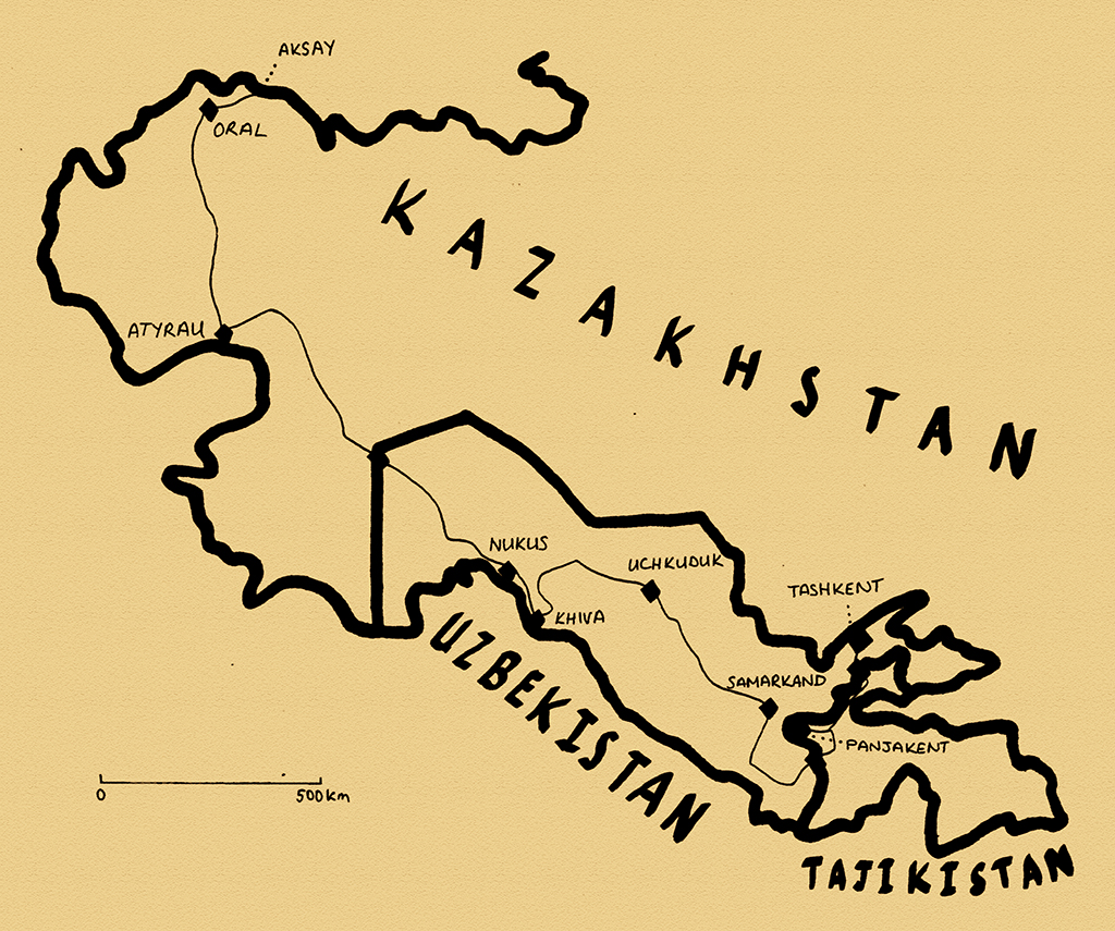
Palace Of Culture Of Aircraft Builders, Tashkent, Uzbekistan
Lisunova is in the east of Tashkent, located between the city centre and the Eastern Airport, and grew up as a residential district to accommodate workers from the nearby Tashkent Aviation Production Association, which produces large Ilyushin cargo aircraft, though has suffered greatly since the collapse of the Soviet Union and has an uncertain future. The area has a distinctly aeronautical theme, with nearby apartments covered in murals depicting aircraft, wings and propellers, the Palace of Culture of Aircraft Builders, a beautiful piece of 1970s Soviet Modernism, and the nearby metro station named after Valery Chkalov, the Russia polar air pioneer who had a huge cult of personality during the pre-Space Age Soviet Union. In addition to these Soviet cultural touches however, Lisunova is somewhere I feel quite personally attached to through multiple visits, almost as a home neighbourhood. Previously, Lisunova was almost entirely Russian, though with a dwindling Russian population demographics are naturally shifting as Uzbeks come to replace the departed Russians. In Lisunova I am living in a safe, leafy, gentle, cosmopolitan slice of Soviet urban planning, and I spend each evening in a local bar drinking cheap, cold draught Qibroy beer, watching the world go by around me and pondering my strong attachment to this place.
Palace Of Friendship Of Peoples, Tashkent, Uzbekistan
Tashkent is by far the largest city in Central Asia, making other capitals such as Bishkek, Dushanbe and Ashgabat look like the glorified provincial towns that they are. Tashkent is a real metropolis, a mature and urbane city, an island of European-styled sophistication amidst the endless agricultural towns and villages of Transoxiana. With the near-total destruction wrought by an earthquake in 1966, whose epicentre was directly below the city, there is nothing of any great age in Tashkent. Nevertheless it is perhaps my favourite city in the Former USSR, for it is a true showpiece of Soviet architecture and urban planning; a living example of Soviet communal living, a spacious and (sometimes quite strangely) uncrowded city of monumental boulevards, (dated) modernist architecture, huge apartment blocks and watered parks. I take myself on a nostalgic tour of my favourite places in the city; starting up in the Khast Imam complex, a rather impotent centre of Islamic study whose totally restored complex includes a beautiful Grand Mosque and the dazzling Barakhon Medressa. From here I move east to the powerful Socialist-Realist Earthquake Memorial, commemorating both the dead, and the fraternal assistance in rebuilding the city from workers and engineers across the Soviet Union. Turning through the shady, plane-lined banks of the Ankhor Canal, I reach the massively remodelled Independence Square, the showpiece of post-independence Tashkent.
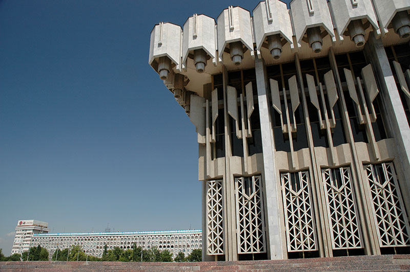
Parliament of Uzbekistan, Tashkent, Uzbekistan
Islam Karimov, Uzbekistan’s despotic president, has a clear wish to homogenise life across Uzbekistan; to impose an unnatural degree of order across the country, which robs many cities of character. At once Tashkent is too large to be robbed of its Soviet character, but simultaneously it is the site of Karimov’s greatest attention, nowhere more so than in Independence Square. Here absolute control and absolute order are manifested in a heavily policed park, whose grass is trimmed by squads of scissor-wielding women, and may not be walked on. A facade of prosperity, of absolute order and calm must be projected to the people, who seem rather out-of-place in this soulless park. Economic stability and reasonable salaries would probably impress people more. I strike west along Uzbekistan Avenue, passing some monumentalist Soviet giants and the nasty smoked-glass Uzbekistan Banking Building, whose pseudo-national style is typical of post independence architecture. From the huge Soviet rotunda of a circus I turn south, reaching the magnificent Palace of Friendship of Peoples, an iconic piece of Soviet Modernism which sits in a large, strangely empty park, backed by what must be some of the longest apartment buildings ever constructed. South from here I venture into Navoiy Park, where the Uzbekistan Parliament Building is one of the few tasteful new buildings, though what use a parliament is in such a dictatorship is highly questionable. From here I take a stroll down Beshagach Street, which runs through Neoclassical columns back to the very centre of the city at Amir Timur (formerly Lenin) Square. Here lies the Hotel Uzbekistan with its mesmerising latticework in the style of Timurid mosaic-work, though I am saddened to see that the ancient plane trees which previously filled the park have been cut down for no apparent reason; a move very unpopular with many of the city’s residents.

Hotel Uzbekistan, Tashkent, Uzbekistan
I spend five full days strolling around Tashkent, indulging myself in the odd sense of nostalgia I have for the city, though I can’t quite fully explain to myself just why I am so charmed by it. I have happy memories of Tashkent; of getting the truck’s suspension fixed here in 2007; of an impulsive decision to get a Pakistani visa here in October 2007, perhaps the most pivotal moment in how this journey came to be so long; and of a rather debauched three weeks of alcohol-fuelled recuperation here with Duncan in November 2009, in between visits to Afghanistan. Tashkent also perhaps best fulfils a hopeless ambition to visit the Soviet Union for real, though through my visits I can feel that the city is very slowly moving away from this past. On my final melancholic day here I walk around the centre, finding a pleasant urban park above one of the exits of the fantastically decorated Kosmonavtlar metro station. I sit on a bench amidst the plane trees, overlooked by a nine-storey apartment block. Around me are old Russian babushkas (grandmothers), Uzbek youngsters, Ukrainians, Tatars, Koreans; often mixed families, all parading gently on this warm Saturday afternoon, after the worst of the daytime heat has abated. Here I see what I fancy is the Soviet dream; a secure, safe, predictable life in a modern, cosmopolitan city built in the European style, way out in the middle of Central Asia. Next to me, an old Russian lady shifts her weight and levers up a loose slat from her bench with a disapproving look. I too wonder how long this island will survive.

Turkestan Range, Sughd Region, Tajikistan
I leave Tashkent in an air of sadness, and a lingering feeling of finality, heading south early on a Sunday morning, out of the city and into the nondescript small farming towns which spread towards the mountains of Tajikistan. I arrive at the border crossing at Oybek to find a sizeable crowd of people being largely ignored by the Uzbek guards. Political animosity between the two countries makes it difficult for their citizens to cross from one country to another across an arbitrary border which divides people who have lived easily as neighbours for centuries. I am the only vehicle waiting to cross the border, though I too must wait, until eventually an idiot of a young customs officer deigns to poke through the contents of the truck; seemingly confounded by anything of industrial manufacture such as mosquito coils or a pot of petroleum jelly. After twenty infuriating minutes of watching his mindless rifling, he gets a call on his mobile phone, cannot be bothered to search any further, and I’m free to leave.
After some poor attempts at extortion on the Tajikistani side of the border, I’m free at midday on the newly built Chinese road which runs first to Khujand, crossing the Syr Darya then heading south past Istaravshan, climbing into the Turkestan Range. As the road climbs steeply, hugging the mountainside, I can see that the Tajiks share the same mindless, belligerent incompetence behind the wheel as their Persian cousins, and the road is lined by the mangled wreckage of lorries which have crashed off a precipice on one of the switchbacks above. The asphalt disappears as I begin the climb of the 3350-metre Shakhristan Pass, which then leads down to the village of Ayni, where after a delicious meal of fatty mutton shashlik, I turn off the main highway onto the rough road above the Zarafshan River.
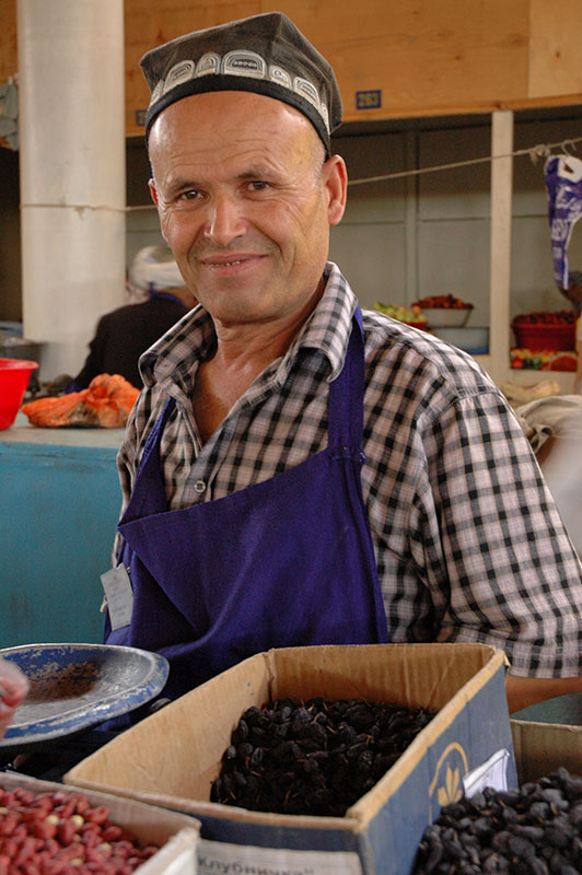
Tajik Fruitseller, Panjakent, Sughd Region, Tajikistan
Upon entering the Zarafshan Valley, the scenery is stunning, with small villages marked by patches of greenery squeezed onto narrow ledges above the river, and the road clinging onto the steep mountainside. I pass friendly villages with mixed Uzbek and Tajik populations on my way downstream along the Zarafshan, which flows eventually to Samarkand in Uzbekistan. After some distance, the valley starts to open up and the villages become larger, dotted with fields of sunflowers and even grapes, until I roll into Panjakent, the principal town of the valley. Panjakent is a bustling market town a with a friendly bazaar, but its main point of interest lies in the hills to the north. Here, I reach the ancient ruins of Panchekanth, which sit aloof from the modern town; a large, grassy terrace of well-weathered mud-brick buildings and walls with just the odd remaining arched doorway, perhaps the remains of ancient Zoroastrian fire temples. Panchekanth was a city of the Sogdians, who had existed in this corner of Central Asia since ancient times, Iranian peoples who formed a series of small states centred around nearby Samarkand, were incorporated into the empire of the Achamaenids and Alexander the Great, and were later famed as traders of the Silk Road until conquered by the Arabs in the eighth century. The legacy of the Sogdians remains however, with traces of Sogdian surviving in the Tajik language, and also in the name of the province in which Panjakent lies: Sughd. Opposite the site itself is an old, dusty museum, whose friendly curator Hikmatullah speaks to me for a long time, showing me a copy of the enchanting friezes unearthed here, whose beautifully coloured depictions of Sogdian kings, noblemen and woman show delicate Persian, Greek and Chinese influence; real art of the Silk Road. He also shows me a Sogdian jar burial, containing the remains of a human body whose bones would have been picked clean by vultures following a traditional Zoroastrian sky burial, and he points at a nearby dakhma (Zoroastrian ‘tower of silence’, where dead bodies were left) in the hills to the south-west.

Hazor Chashma Lake, Sughd Region, Tajikistan
Having stocked-up with provisions in Panjakent’s bazaar I head south, along a rough track which climbs up into the Fann Mountains, part of the Hissar Range which stretch west into Uzbekistan. As I drive ever upwards I start to pass a string of seven lakes, each of deep blue water held behind landslides which have blocked the river into this narrow valley. With increasing altitude, the scenery becomes ever more spectacular and terraces appear on the steep valley-sides, dry-stonewalls, irrigation channels, fruit trees and simple mud-brick homes of purely Tajik villages. Men smile and press their right palms to their chests as I pass; an idyllic mountain paradise untouched by modernity, which once again reminds me more of northern Pakistan or Afghanistan. It’s as if all the rigours of the twentieth century had simple bypassed this tranquil valley. In the afternoon I reach the end of the road in the village of Marguzor, which spreads across three valley-sides around the sixth of seven lakes, a truly beautiful place, though it’s clearly also impoverished and must be terribly bleak and isolated during winter. I politely decline an invitation from a gentleman to stay at his home, and instead park up at the lake-side for the night, watching a group of local boys fishing in the lake’s cold, clear water. For the first time since leaving the mountains of Kyrgyzstan I have a cool and pleasant night.

Tajik Boys, Hazor Chashma Lake, Sughd Region, Tajikistan
In the morning I leave the truck and begin walking on the well-worn village paths up to the seventh and final lake, known as Hazor Chashma (‘Thousand Springs’ in Tajik). Leaving the village houses, I climb past occasional shepherd’s huts and small, walled plots of crops, passing groups of children leading donkeys downhill carrying bundles of juniper wood from much further up the valley. I soon give up any idea of strenuous hiking up to a pass to view the snow-peaks which lie beyond the valley walls, instead enjoying the wonderful lakeside serenity and occasional donkey traffic, sitting in the cool shade and drinking in the beauty of my surroundings, in view of the ferocious heat I’ll be driving through in the coming days. With a touch of melancholy I realise this will be one of the last moments where I can witness such unadulterated magnificence before I return to the dull landscapes of Europe. There is no sound to pollute the tranquillity here, just the gentle lapping of the lake’s waters, and the occasional lament of a donkey in the surrounding valley. Up beyond the head of the lake is a steep hillside, which on close inspection I see is dotted with more mud-brick hovels, one of the most hidden and isolated settlements I have ever seen, totally without modern infrastructure. Two boys plod down on a donkey and we have a halting conversation in my few words of Persian, but they nevertheless manage to invite me back to their home, though wishing to remain where I am, I decline. Once again I’m faced with the uncomfortable truth that nicest people in the world – the friendliest, kindest and most trusting – are those that have the least.
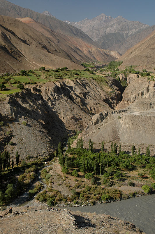
Zerafshan Valley, Sughd Region, Tajikistan
I retrace my route back down to the road, which formerly would have led west to Samarkand, however Karimov’s dislike of Tajikistan has seen him close the border for no reason other than spite, stifling tourism and communication in this beautiful region of Tajikistan, which now lies isolated between the mountain passes which separate it from both Khujand and Dushanbe. Rejoining the main M34 Highway towards Dushanbe, I soon have a rather unpleasant experience. A car driven by a wild-looking young man passes me very close, grazing my bull-bars. There is no damage to the truck, but a crease in the bodywork of the other car, which stops, and whose driver demands payment, which I of course refuse. After perhaps half an hour of threatening and at times abusive behaviour, the driver’s father arrives in another car. Although he is a revolting, volatile, self-adoring fool with a squeaky voice, his son’s behaviour suddenly improves, and we drive to a police post some distance down the road.
The road winds up the green slopes of the Zarafshan Range, plunging through the infamous Anzob Tunnel, a botched Iranian engineering project whose unlit five-and-a-half kilometre interior is almost perpetually flooded, with holes in the road surface large enough to founder cars in waist-deep water. Reaching the police checkpoint, arguments continue, though I refuse to do anything without informing my embassy. By now in a rush, both the driver and his father agree to meet me at the British Embassy the following day in Dushanbe, telling me that the police will hold my driving license until the matter is resolved with the Dushanbe Traffic Inspectorate. However, once everyone else has departed, the police officer, perhaps sensing that I am not at fault, or perhaps not wanting the burden of starting an investigation, hands me back my license, and I leave.

Soviet Border Marker, Surxondaryo Region, Uzbekistan
Beyond the checkpoint the road winds down the Mediterranean-like foothills, dotted by the holiday homes of the capital’s rich, into the sweltering heat of Dushanbe. I had planned on spending a couple of days here but, having found the city rather dull on my first visit in 2007, and not wanting to run into my accusers, I bypass the city and head straight for the Uzbekistan border at Dusti. I leave Tajikistan without an issue, and am even given a melon by a customs officer who is a frustrated piano player, and asks me to invite him to the UK. However, here I am once again subject to the bad relations between the two countries, as vehicular traffic is reduced to a trickle through the Uzbek customs yard, with thorough and time-consuming searches. I have to spend the night in no-man’s land, under an old Soviet monument to fraternal relations between Soviet nations; something which seems in short supply here. I do make friends with the only other car driver here, Nazim, a Tajik who is driving to Almaty. When we are finally admitted to the customs yard mid-morning the following day, Nazim is first in, though I need to lend him some tools to start dismantling parts of his engine so that the Uzbek guards can read his engine number. After my own thorough search, I’m through ahead of Nazim and wait for him a short way down the road, taking a very refreshing dip in the cool waters of an irrigation channel. Before long Nazim arrives and we have a great late lunch together, which he insists on paying for, before we go our separate ways.

Hissar Range, Surxondaryo Region, Uzbekistan
After passing the city of Denov I turn off the M41 Highway, heading west on small roads, bypassing Termez down on the Amu Darya where I had crossed in and out of the country from Afghanistan almost two years earlier. The road climbs through small villages of mud-brick houses, decorated sometimes with floral motifs and far more modern than the hovels I had seen in the Fann Mountains. Shepherds on donkeys move their herds across the landscape which is a near uniform brown but for the occasional low limestone outcrop; the air is thick with dusty haze and the heat torrid, giving these low southerly outliers of the Hissar Range the look of the Judaean Hills of Palestine. I stop in the early evening in the pleasantly green hill town of Boysun which is somewhat different from the typical lowland cotton-farming towns which dot most of the country, then move on to find a wonderful camping spot just out of town, overlooking the road which heads west towards Samarkand and Bukhara in this Biblical landscape, where I enjoy a pleasantly warm night under the stars, relieved to be out of Tajikistan.

Friday Mosque, Katta Langar, Qashqadaryo Region, Uzbekistan
In the morning I soon join the M39 Highway, which climbs gently to the ‘Iron Gates’ a natural defile in the Hissar Mountains through which traffic must pass; rather like the Khyber Pass, this transport bottleneck has a long history, linking Balkh and Samarkand, and has long-witnessed the passage of the armies, trade caravans and pilgrims which define the region’s history and culture. Today the traveller is delayed here by traffic jams caused by the authorities checking vehicles and passengers arriving from the Afghanistan border region, though I manage to pass without significant delay, turning north in Guzar towards Shahrisabz, hometown of Tamerlane (Timur).
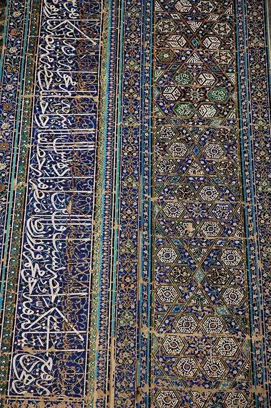
After around thirty kilometres however I turn east, back into the foothills of the Hissars, winding up a narrow valley of powdery orange-brown rocks and scattered mud-brick houses to the large village of Katta Langar, where on a flat-topped hill sits the red-brick mausoleum of the sixteenth century Sheikh Muhammad Sadik. Said to be an adherent of a minor Sufi sect which was pushed into this small valley by the Naqshabandi Order (who spread from Transoxiana to the Indian Subcontinent at around this time), the mausoleum is restrained, lacking the dazzling faïence of the country’s most famous shrines, but of very elegant, Timurid proportions and set amidst a delightful cemetery of pistachio trees and ancient gravestones with Arabic inscriptions. Across the valley, where the bulk of the village houses lie along winding, unpaved alleys, is the Friday Mosque which, while plain on the outside, has a dazzling interior; a floor covered in aged carpets, walls of blue, geometric and floral tiles and a beautiful faïence frieze of Arabic below a decorated wood-beam ceiling supported by finely carved oak pillars. The mosque is said also to date from the sixteenth century – though I wonder how much of what survives is original – and is unusual for reversing the typical combination of exuberant exterior and plain interior.
Tilework, Ak-Saray Palace, Shahrisabz, Qashqadaryo Region, Uzbekistan
Back on the main road I stop in Shahrisabz to admire again the crumbling ruin of Timur’s fourteenth century Ak Saray Palace, whose impossibly vast proportions surpassed the technologies of its time and soon crumbled, leaving evocative ruins which have thankfully thus far been spared the insensitive ‘restoration’ of many of the country’s other great architectural monuments. Only the soaring remains of the palace’s huge fallen arches remain, with great swathes of the never-finished exterior tilework, some of the most magnificent in the entire region. Elsewhere in town are beautiful mausolea containing members of Timur’s family, and a simple tomb thought to have been intended for Timur himself, though none have the same air of decaying and derelict megalomania as his fallen palace. Shahrisabz is otherwise a pleasant, bustling market town relatively unspoiled by tour groups and stopping at a tyre repair shop on my way out to get a puncture repaired, I am invited for lunch by the friendly Uzbek family who run the shop, and am not even charged for the repair.
North of Shahrisabz the road climbs a rocky hillside to reach the cool Takhtaqaracha Pass where I am delighted to find a spring whose cool, clean water is invigorating after days of driving through the torrid heat of the plains. The road descends gently to the north, through charming villages of ancient walnut trees and open water channels, dropping into the farming villages around Samarkand. The temperature is still noticeably cooler compared to the south side of the pass, and on a whim I decide to camp on a hill near the airport, overlooking Samarkand whose dusty skyline of low houses and mulberry trees is dotted by turquoise domes and huge portals; the heart of Transoxiana.

Petroglyphs, near Debaland, Navoiy Region, Uzbekistan
In the morning I check into Bahodir’s B&B in Samarkand, an old haunt from 2007 and 2009 where the family welcome me warmly, though are worried that I have been travelling for four continuous years rather than getting married. Bahodir’s is perhaps the greatest node for travellers in Central Asia, and I spend twelve days here relaxing, meeting other travellers and exchanging stories from the road, in a manner similar perhaps to the merchants who paused in caravanserais along the Silk Road centuries ago. The old centre of Samarkand seems to become ever more sanitised and charmless as the years advance, though the ensemble of medressas (seminaries) around the Registan (central marketplace) remain a magnificent sight; some of the the finest Islamic architecture on the planet. I make a few forays into Samarkand’s modern city, which is refreshingly down-to-earth and retains architectural traces of the Tsarist Russian Empire. Mostly however I spend days lounging in the courtyard at Bahodir’s, drinking cold Pulsar lager whilst chatting with fellow travellers.

Central Square, Zarafshan, Navoiy Region, Uzbekistan
Eventually I extricate myself from the amiable torpor of Bahodir’s and start my final journey towards Russia and Europe. I drive north-west from Samarkand towards the city of Navoiy and the fearsome heat of the Kyzyl Kum (Red Sand) Desert. I divert north-east briefly towards the Kazakhstan border, in order to find some petroglyphs on the desert-varnished rocks which lie in the hillsides above the road, then turn back and begin my journey into the heart of the desert. Away from the country’s main transport artery, this road exists to serve the remote mining towns of the Kyzyl Kum, and my first stop is in the gold mining town of Zarafshan. A modern, planned town founded in the late 1960s, I’m surprised to find that perhaps half the population are Russian, and Russian language is found on signs and shop-fronts, as if it were a preserved bubble of the USSR. As I drive out of town in the late afternoon, I am again surprised to see occasional yurts (nomad tents) dotted in the desert, inhabited presumably by once nomadic Karakalpaks, an ethnic group closely related to the Kazakhs to the north. As the sun approaches the horizon, and the heat finally starts to subside, I pull off into the sandy desert and make camp, spending a glorious night under a star-filled sky, lying on the back of the truck in nothing but my underpants.

Kyzyl Kum Desert, Karakalpakstan Republic, Uzbekistan
I reach the uranium-mining city of Uchkuduk in the morning, and need to find diesel. As in most parts of the country, the fuel pumps here are dry and diesel must be sought out on the black market; in this instance I befriend a minibus driver who leads me back to his home, where he pumps forty litres of diesel for me from an unseen source below a trapdoor in his garage. At a checkpoint on the edge of Uchkuduk the police stop and advise me to carry plenty of water and extra fuel, and then I am off into the depths of the Kyzyl Kum Desert on a road which I have long wanted to drive. I enter a landscape of endless, undulating desert, usually sandy, though always vegetated, and it is more than an hour before I pass another vehicle. Only once do I pass a remote settlement near an old irrigation canal, and as I enter into the autonomous republic of Karakalpakstan the landscape starts to alternate between sand and the wasteland of muddy plains which typify this blighted republic. By mid-afternoon I reach an unexpected roundabout in the middle of nowhere, where I turn south towards the Khorezm Oasis on the Amu Darya River, briefly rejoining the main road and then heading to the ancient city of Khiva.

Chilpyk Dakhma, Karakalpakstan Republic, Uzbekistan
Khiva, which I had previously visited in 2007, was the capital of the Khorezmian State, and later the Khanate of Khiva, famed for its trading of Russian slaves in the eighteenth and nineteenth centuries. Modern-day Khiva is visited by hordes of tourists and feels like a large open-air museum, but it’s my last glimpse of Central Asia and I’m content to spend a nostalgic morning wondering the streets of the Itchan Kala; the much restored, walled old-city, before taking to the road once more. I drive north-west through the Khorezm Oasis, crossing the muddy Amu Darya on a heavily patched steel pontoon bridge as the sun lowers towards the horizon. Not far from here I leave the highway and drive into the desert, to camp at the foot of the beautiful Chilpyk Dakhma, a Zoroastrian ‘Tower of Silence’ where the deceased were laid out to have their bones picked clean by vultures, thought to be more than two thousand years old and with views over the Amu Darya as it makes its way through the utterly barren landscape, with the irrigated fields of Khorezm in the distance.
In the morning I make my way to the city of Nukus, which feels more than ever (on my fourth visit) to be at the edge of the world. There is no fuel for sale, no ATMs, the city’s only internet cafe is closed, the tap water is undrinkable, and I fail even to find a place to eat anything more than limp, warm, fried matter. It’s this extreme isolation however which gives Nukus its character, as capital of the once fertile, but now desperate Karakalpakstan Republic, which feels the full effect of the Aral Sea Disaster. It was here that artist Igor Savitsky managed to secrete an astounding collection of paintings from zealous Soviet censors, and the modern Savitsky Museum is an astounding collection of non-conformist twentieth century Russian realism and impressionism which has been preserved in this far flung outpost of a city.
I leave Nukus in the afternoon, passing through an increasingly desolate landscape of dying irrigation canals and salinified fields, until I reach the twenty-five metre high cliffs of the Ustyurt Plateau; a stony, desert wasteland which stretches to the Caspian Sea. Here I break my journey, camping next to the Davit-Ota Necropolis on the edge of the plateau, spending another warm night under the stars in a starkly beautiful and rueful environment. From here it’s a three hundred kilometre drive following railway tracks to the border post, passing utter desolation, at most times with nothing whatsoever to catch the eye. Occasional, impossibly isolated, sun-beaten, fly-blown settlements loom on the horizon to the left; small railway staging-posts of oblivion, where life must be near unbearable. Around one hundred kilometres short of the border a camel which has been killed by a truck lies sprawled at the roadside, where in the 45º C midday heat its poor owners are scooping its insides out in a swarm of dust and flies. Karakalpakstan is certainly one of the most desperate and stricken regions of Eurasia which I have seen.

Freight Wagons, near Beyneu, Mangystau Region, Kazakhstan
I have an arduous three-hour wait at the border crossing which is shadeless and plagued by flies and dust-storms, though when I am waved through in the late afternoon I am conscious that the crowds of friendly Uzbek migrant workers on their way to Russia have been waiting far longer than I have. On the Kazakhstani side the road is an appalling washboard, but in the first town of Beyneu I am re-acquainted with the delights of civilisation; a well-stocked supermarket, a simple restaurant and an ATM. I leave Beyneu well after dark, deciding in view of the terrible heat and some noises from the truck’s front axle against heading south towards Aktau and the pilgrimage sites of the Ustyurt Plateau (which I would visit in 2014) and heading instead north towards Atyrau, camping next to the railway tracks and reaching the unlovable city of Atyrau late the following morning. I spend five comfortable days with Akmaral in Atyrau, contemplating my return to Europe. My plan is to drive to Ukraine; however I have no visa for Russia, and after being unable to obtain a visa in either Bishkek or Tashkent, I have only one last chance at the consulate in Oral, five hundred kilometres to the north, close to the Russian border.
Whilst in Atyrau I meet a group of Slovakians who have been robbed at gunpoint during daylight hours in the middle of the city, and James, an American cyclist who is also staying with Akmaral is knocked off his bicycle in a hit-and-run accident by a local driver. This seals my impression of Atyrau as perhaps the most unpleasant city I have visited on the entire trip, and I am glad to leave, heading north parallel to the Ural River across featureless steppe, which fades gently from semi-desert to sub-Siberian rangeland as I approach Oral. If I cannot obtain a Russian visa here, then I will need to make a very long detour through Turkmenistan, Iran and Turkey in order to reach Europe, and will need to double back to Almaty immediately to start obtaining visas. It is to my great relief then that I am able to get a ten day transit visa same-day, and in the late afternoon I am driving north-east, crossing the border on the Ural River at midnight and heading towards Orenburg.
And so concluded my 2011 journey through Central Asia, which had shown me so many more parts of Kazakhstan and Tajikistan, and some new places in Kyrgyzstan and Uzbekistan; meaning now that I had seen almost every part of Central Asia. This region, still relatively recently opened up to the outside world, with an alluring mixture of magnificent history, crumbling, atmospheric monuments, gorgeous scenery and welcoming people roughly book-ended the beginning and the end of the initial four-and-a-half year section of the Odyssey, and remains perhaps my favourite region of the world. Ahead of me now was the final drive back through Russia, Ukraine and Moldova, to finally return to the UK at the end of the year, after fifty-five months away.
