
Stage 28 – Kazakhstan & Kyrgyzstan: The Kazakh Steppe [2/2]
Until the disastrous Soviet program of forced collectivisation in the 1920s, the Kazakhs were an almost entirely nomadic society, who by their very nature left little mark on the land they inhabited. In the month I had just spent in Kazakhstan, making my way from the Russian border in the north-west to the extreme south of the country, I had passed many of the country’s oldest cities, some reduced to lifeless piles of dust, others surviving to this day. All however were the product of the settled societies which stretched south to Persia. Having made a brief side-trip into Kyrgyzstan to renew my visa, I had four more weeks of travel ahead of me in Kazakhstan, during which I would penetrate the very heart of the country, to see the subtle yet fascinating legacy of the successive nomadic nations who have inhabited the steppe. Beyond this, I would head for the far south-east of the country, along the Chinese border, where I would find some of Central Asia’s most haunting landscapes.

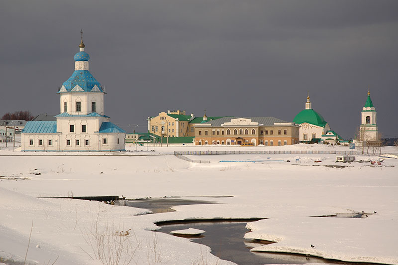
Petroglyphs, Tamgaly, Almaty Region, Kazakhstan
I re-enter Kazakhstan in the early hours of the 14th May 2011 in the town of Korday, after a sixteen hour side-trip through Kyrgyzstan. I drive east for two more hours before pulling off the highway at the turning north to Kopa, where I continue in daylight after a few hours’ rest. Now in late spring, the steppe is still green and covered in places by huge patches of striking red poppies and purple wild flax flowers. My destination is an isolated spot out on the steppe know as Tamgaly. Here, on the edge of the huge grasslands which stretch north to the edge of Siberia are a series of step-like rocky outcrops with large, smooth blocks and boulders covered in shiny black desert varnish. Tamgaly has a comparative abundance of springs, vegetation and shelter compared to its surroundings and has attracted successive pastoral communities for millennia, who since the Bronze Age have left striking petroglyphs describing their culture and customs.
Tamgaly is indeed perhaps the most interesting of Central Asia’s many petroglyph sites, for it appears to have a central cult area where the stylised rock inscriptions are most prolific and expressive; an area which may have been sacred, with altars used for sacrifices. Alongside the common images of hunting and various animals is a true masterpiece of rock art; a pane showing several large, solar deities (‘sunheads’), animals being enchanted by shamans, and a group of men dancing around a woman giving birth. Dated to the second half of the fourteenth century and thirteenth century BCE, in the Middle Bronze Age, they are a fascinating and deeply intriguing testament to the customs of the distant, steppe-dwelling ancestors of Eurasians.

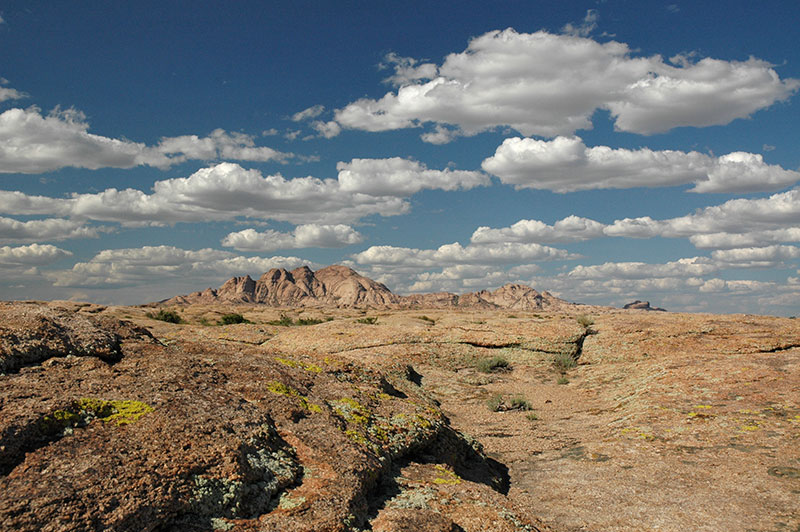
Karatau Mountains, near Kentau, South Kazakhstan Region, Kazakhstan
I return to the main road, doubling back to Taraz where I stop for a few days, then continue towards the low, twisted peaks of the Karatau Mountains, a north-westerly spur of the Tien Shan which also roughly delineates the boundary between historically settled and nomadic civilisations. I pass through the desolate town of Zhanatas, a phosphorite-mining centre which was evidently in the process of expansion when the Soviet Union collapsed in 1991, and with it the market for phosphorite, leaving a town full of huge, empty, decaying apartment buildings around a run down centre, where I am hauled in for passport registration by suspicious police. Beyond Zhanatas the road enters the steppe again, curving through isolated towns such as Sudakent and Chulakkurgan, crossing the low, broken massif of the Karatau Mountains then dropping down via Kentau to Turkistan and the broad Syr Darya Valley. Here I rejoin the main highway down which I had driven last month, retracing my steps to Kyzylorda where I stay for a night before turning north, to the very centre of Kazakhstan.

A381 Highway, Kyzylorda Region, Kazakhstan
The road out of Kyzylorda leaves behind the near-desert of the Syr Darya Valley, entering country which fades imperceptibly into scrubby steppe dotted with saxauls and wormwood, from which tortoises emerge to make the hazardous crawl across the highway. The asphalt soon runs out, but the track has been recently graded and seldom slows my progress. Off to the west I see a low escarpment of brilliant red-orange sandstone, but other than this there is nothing to catch the eye and the journey becomes mesmerising. After several hours I pass a lonely Kazakh cemetery to my right, on the banks of the Sary Suu River. Not long after this the smokestacks of an industrial city loom on the horizon and large, whitewashed concrete letters at the roadside announce my arrival in the city of Zhezkazgan.
Founded in 1938 principally to exploit deposits of copper, and made infamous by Solzhenitsyn’s descriptions of the nearby Kengir Gulag, Zhezkazgan is a surprisingly pleasant city surrounded by hundreds of kilometres of steppe in each direction. Its neat, Khrushchev-era city blocks are dotted with numerous Soviet murals and sculptures, and the city has become associated with space exploration, with returning cosmonauts landing in the vast openness of the nearby steppe and ceremonially planting a tree in the city. I’m hosted in Zhezkazgan by Laura, a Californian Peace Corps Volunteer who immediately takes me to the home of her Kazakh ex-host family where two new volunteers are being welcomed with a traditional dastarkhan (feast) of Kazakh specialities such as baursak (deep fried dough pockets), sweets, fruit and vodka, though thankfully no sheep’s head.
Moustachioed Kurgan, Ulytau, Karaganda Region, Kazakhstan
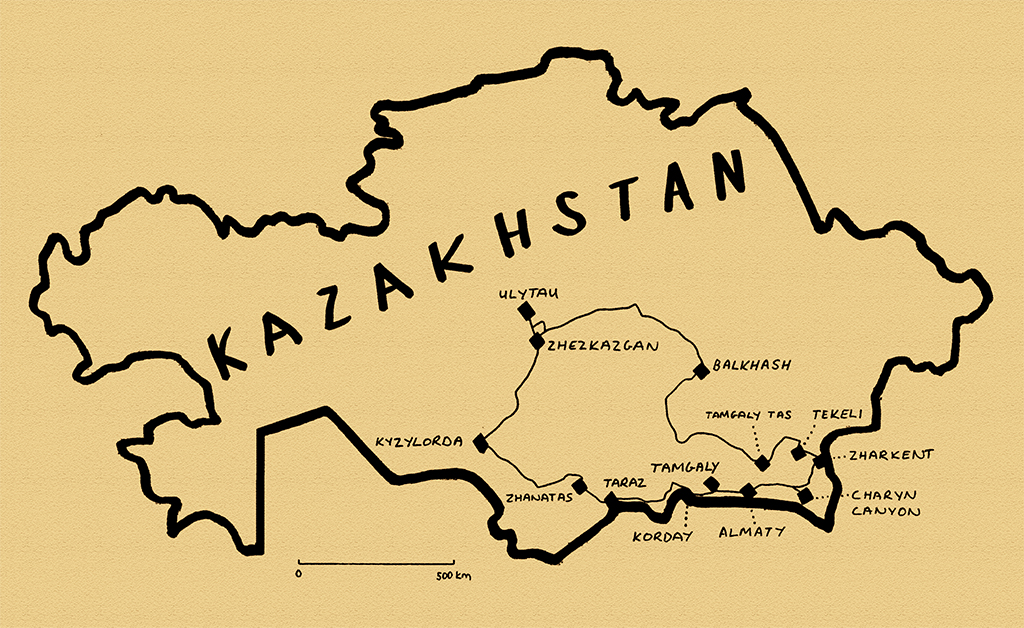
North of Zhezkazgan is the region of Ulytau, located centrally both in the country, and in the identity of the Kazakh people. On the main road I pass a tall monument to the unity of Kazakh peoples, signifying both the geographical centre of the country and (conveniently) the point where the three Kazakh zhuzes (clans or hordes) came together to fight their common enemy the Dzungars, who came from China in the eighteenth century. The small, nondescript town of Ulytau itself is set amongst low basalt mountains, something of an oasis in the surrounding dry steppe, with rich green grass and even stands of birch trees. With such an attractive steppe environment it is not surprising that the area is of historical importance, with an abundance of archaeological sites. Out in the steppe just east of town are stone kurgans (barrows), which in each case are part of a larger construction, with two curving lines of stones running roughly parallel away from the kurgan to end in a larger standing stone. It is not clear whether these constructions, known as ‘moustachioed’ kurgans are observatories, grave markers, or ritual constructions.
Mausoleum Of Alasha Khan, Karaganda Region, Kazakhstan
The precise origins of Kazakh people are not entirely clear, complicated by the fact that the term ‘Qazaq‘ had been used for centuries to denote a free wanderer (the term ‘Cossack’, for an entirely unrelated ethnic group is likely to come from this root). What does seem firmly routed in truth is that Abu’l-Khayr Khan, a descendent of Chinggis Khan (Genghis Khan) united the nomadic Central Asian tribes in the mid-fifteenth century, and that it was Janibek Khan and Kerei Khan who rebelled from this union to found the Kazakh khanate (tribal chiefdom). What is far less clear is the unification of the three Kazakh zhuzes under a legendary figure known as Alasha Khan.
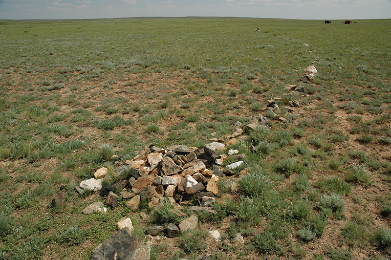
The day after visiting Ulytau I drive north and east from my night stop in the dull mining town of Satbayev, into the steppe, which here is dotted by beautifully eroded, softly multicoloured hills. Just outside the village of Malshibay is the mausoleum complex attributed to Alasha Khan. It’s a striking building with beautiful (restored) geometric brickwork, thin bands of turquoise tiles and a striking vaulted interior. A thin passageway runs around the chamber between inner and outer walls, and a stairway leads up to the roof. From here there is a fine view overlooking a number of mausolea belonging to lesser notables, some poignantly decayed with broken domes and scattered, fallen masonry. With the main mausoleum dated to the tenth to twelfth centuries, it seems unlikely that Alasha Khan was a real person who united the Kazakhs, but this seems of only minor importance. Groups of locals arrive at the site, saying their prayers standing up, facing the mausoleum’s portal, or sitting on the ground in groups outside one of the smaller mausolea. This is the living continuation of a thick fabric of legends attributed to this area, passed down through generations orally by these wandering, nomadic people of the steppe.

Petroglyphs, Terekty Aul, Karaganda Region, Kazakhstan
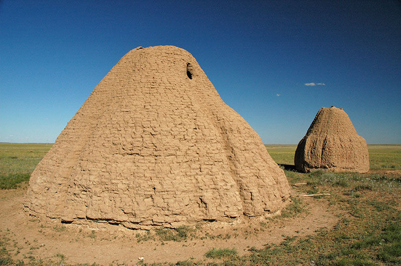
From Malshibay I leave the road and head south on tracks back towards Zhezkazgan, reaching another group of mausolea. Here the principal shrine is also red-brick, though coarser than that of Alasha Khan, with a modern turquoise-tiled dome and a plain interior covering two graves, said to be that of Jochi Khan and his wife. Jochi was the first son of Chinggis Khan (quite possibly illegitimate, as his wife Borte gave birth soon after returning from the rival Merkit tribe who had kidnapped her in an earlier battle) and campaigned with his father as the Mongols spread east. However, he seems to have become estranged, possibly following his father’s choice of his younger brother Ögedei as successor, and he never returned to his father’s court in Mongolia, later dying in February 1226 in a hunting accident. It’s tempting to think that this plain mausoleum contains the grave of a son of one of the greatest men in history, but like so many of the scant historical remains on this huge steppe, it is in reality an intriguing mystery.
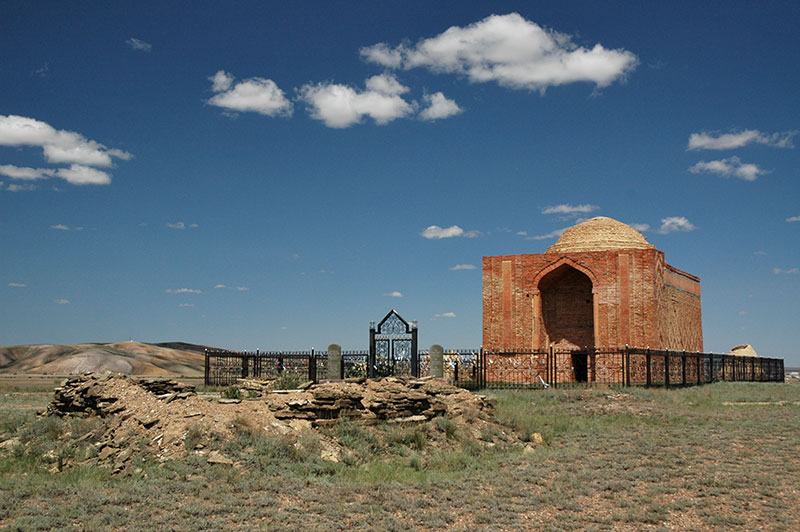
Kazakh Mausolea, near Kyzylzhar, Karaganda Region, Kazakhstan
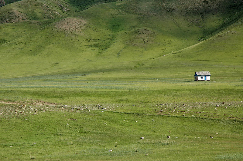
Turning away from Ulytau and Zhezkazgan in the morning, I continue through a similar landscape of rolling green steppe, pulling off the road at a scrubby spot and driving briefly north to see the petroglyphs at Terekty Aul; here carved deeply into the soft pink basalt, rather than the usual picketing into dark, desert-varnished rock. This area too seems to have had some spiritual significance as there are a number of large nearby mausolea. Indeed, all along the road east towards Karaganda the landscape is regularly dotted by ancient graves and shrines, and I find myself drawn to stop at each of them. In one particularly ancient burial ground I find graves spanning right across time; from the most ancient kurgans, through megalithic slab graves, to mud-brick mausolea and finally recent graves, each with a headstone and small perimeter fence. At another stop near Kyzylzhar there are two very large mud-brick mausolea whose flutes have been softened by years of exposure to the elements, giving them the look of two giant lemon-squeezers. I find these silent, deserted burial grounds quite wonderful; perched out on the beautiful green, wormwood-scented steppe, the only visible legacy of a civilisation; nameless graves whose identity has passed into obscurity just like the generations of departed nomads, yet whose very presence on the plains, visible from afar, provides a reassuring ancestral link between the people and their homeland.
Bektau Ata, Karaganda Region, Kazakhstan
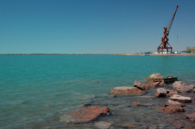
Shortly beyond the town of Atasu, where I stop for dinner, I turn south-west off the main highway into an area of beautiful, table-flat steppe defined by distant low mountain ridges, seemingly good, green pasture yet strangely devoid of population. Continuing the following day, through the isolated town of Akadyr and more marvellously empty terrain, I join the country’s main highway, which connects the new capital Astana with Almaty, its largest city, and is in refreshingly good condition. I stop briefly at the beautiful pink-orange basalt massif of Bektau Ata, whose softly-sculpted, lichen-covered volcanic rocks are dotted with lakes and imbued with legends, before continuing to the city of Balkhash. Lake Balkhash is one of the largest in Asia, a shallow, sickle-shaped smear of bright blue water, saline at its eastern end yet composed of freshwater in its larger western section. The exploitation of nearby copper reserves has overtaken fishing as the main economic activity and Balkhash, the principal lakeside settlement is, like Zhezkazgan, a neat and attractive mining city. Streets of colourful Stalinist buildings (many built by Japanese prisoners of war) run down to the turquoise waters of the lake where a sandy beach is dotted with families, giving the city the air of a friendly, unpretentious seaside resort, albeit with a background of smokestacks and other heavy industry, and highly polluted water.
Lake Balkhash, Balkhash, Karaganda Region, Kazakhstan
I continue my journey south through the semi-desert along the curving western edge of the lake, with beautiful views across its reedy shores and peppermint blue waters, passing the site of the Soviet-era Saryshagan Missile Testing Range and reaching the southern edge of the lake in the late afternoon. Beyond the lake, the highway skirts around a barren sandy wasteland, which I enter on a nearly deserted road turning north acutely from the main highway. I cross a bleak area of undulating scrubby dunes for around fifty kilometres before suddenly entering the delta region of the Ili River, which runs from the eastern Tien Shan in China to Lake Balkhash. The delta is a real paradise; a bird-filled wonderland of ponds, reeds, trees and dunes, and after stopping for the day in the waning light, the cool night air is alive with the sound of frogs and buzzing insects; wholly unprecedented given the barren wastes I’ve been driving through for much of the day. This fertile region is known as Zhetysu (Seven Rivers) and until 1864 was part of Qing Dynasty (Manchu) China, with Lake Balkhash forming the border with the Russian Empire.
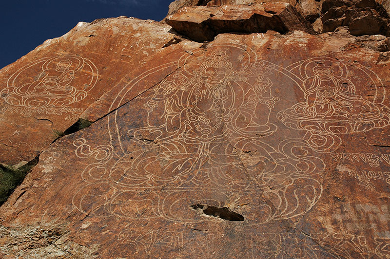
Buddha Images, Tamgaly Tas, Almaty Region, Kazakhstan
The following day I make my way upstream along the Ili River, passing through small farming communities towards Lake Kapchagay, crossing the river on the highway to Almaty then turning downstream briefly, where Ili flows through a broad grassy valley between low hills. Here, on the left bank of the river, beside a natural historical crossing point, is a rocky outcrop known as Tamgaly Tas, which bears the inscriptions of several cultures, from ancient Turkic runic, the instantly-recognisable sharp characters of Tibetan script to very beautiful vertical verses of Dzungar script. The main attraction however are three large carved images of the Buddha on a lotus leaf, the largest, central image in the teaching position, as if giving a sermon on the bank of the river. The exact origin of the Buddhas is unknown, and while a Kazakh legend dates them to the tenth century, it is likely that they are of Dzungar origin. The Dzungars were an Oirat (western Mongol) tribe and the last nomadic civilisation to threaten China. They were also Buddhists from the sixteenth century onwards, and displaced Kazakhs from this area in the mid-seventeenth century, only to be chased back out in the early eighteenth century when weakened by Qing Dynasty China to the east, and thus the carvings are likely to date from between these dates.
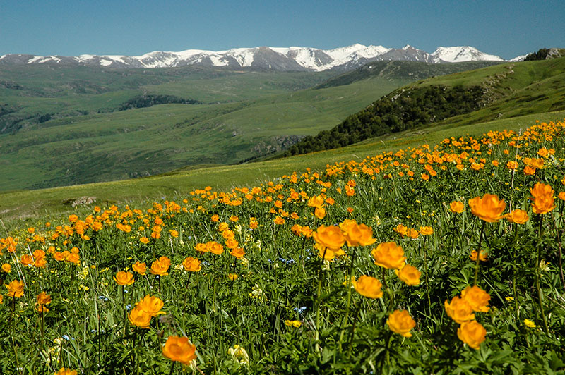
Wildflowers, Dzungarian Alatau, Almaty Region, Kazakhstan
My next destination is Tekeli, an attractive small town set amidst the lower slopes of the Dzungarian Alatau, a 450 kilometre-long range of mountains which define part of the Kazakhstan – China border. I’m hosted here by Thomas, a French expatriate who works in the town’s malting plant, the only one in Central Asia. Tekeli is a pleasant place, and in the nearby Kora Valley we see an ancient carving of a Buddhist stupa on a large rock next to the river, but it is the grassy mountains immediately above town that are truly unforgettable. We drive partway up in Thomas’ company 4×4, then set out on foot heading east and up across rolling hills. Soon we encounter huge flower-filled hillsides, shaded with bright orange poppies, yellow buttercups, blue forget-me-nots, white daisies and purple asters. As we climb higher, we can see into a yawning valley, with long-range views over a succession of emerald-green hills which, on their upper slopes fade immediately into a crest-line of glaciated and snowcapped peaks. Dotting one nearby grassy saddle is a bright-white Kazakh yurt (nomad tent), an iconic image of these once-nomadic people all but absent from the steppes; a vital part of Kazakh culture wiped out by Stalin’s collectivisation. We approach the yurt, inhabited by a friendly Kazakh family who offer us tea and milk. They explain that they spend the summer season here grazing their animals, returning to the nearby city of Taldykorgan for the winter. To glimpse the remnant of an ancient nomadic culture here, in one of the most beautiful places I have ever seen, makes it one of my favourite experiences in all my travels in Kazakhstan.
Dzungarian Alatau, Almaty Region, Kazakhstan
I make my way slowly south-east from Tekeli, crossing to a rough track on the far side of the Koksu River to find the ancient site of Eshkiolmes, where I park the car amongst unexcavatd grave mounds and content myself for several hours walking around the country’s largest petroglyph site, finding perhaps several hundred of the ten-thousand-odd petroglyph images said to be spread over several small side valleys. Continuing south-east I pass more magnificent grassy foothills of the Dzungarian Alatau on quiet back-roads, before dropping down into a corridor between the mountains and the Ili River which contains the main highway running east from Almaty to the Chinese border. Here, on this living remnant of the Silk Road, the landscape reverts very abruptly to the familiar dry plains of wormwood-scented grass, dotted by crumbling mud-brick mausolea in various states of atmospheric decrepitude. Occasional villages and small towns are lined by tall, brush-like poplars and leafy mulberry trees, giving a strong hint of Chinese Turkestan. Bactrian camels appear, corralled in stinking, screeching, indignant herds. I watch as one bolts and dashes with remarkable speed across the steppe, parallel with the road, chased by two horsemen who fail to apprehend it in the time it takes me to drive past the scene. This is classic Central Asia.

Mausolea, near Konyrolen, Almaty Region, Kazakhstan
The busy market town of Zharkent is as far as I go towards the Chinese border, and the province of Xinjiang of which I have such fond memories from a 2003 trip across Asia (by public transport). Here, after finding lunch in a Uyghur cafe, I set out to look at the town’s only architectural attraction, which lies in a large, poplar-flanked courtyard amid the slightly chaotic market streets. The late nineteenth Yuldashev Mosque is a highly unusual Islamic structure created by a Chinese architect; with a tiered, wooden pagoda roof on the main hall and a similar minaret, colonnaded outer walkways and colourful Chinese-style paintings under the roof eaves, the mosque has a very strong resemblance to a Manchu-era Buddhist temple; at once rather attractive and novel, but at the same time lacking the pleasing geometrical grace of classical Islamic architecture. The mosque’s obstructive female caretaker accompanies my every step around the building with thinly disguised contempt, and so I soon leave.
From Zharkent I head south, crossing the Ili and heading straight for Almaty, where I am hosted by Dan, a British expatriate and his Kazakh fiancée Aliya, in their comfortable apartment overlooking the city centre. Dan, an English teacher and Russian speaker is a kind and sensitive guy, and I am glad to meet a fellow Englishman who has an affinity for this country and an appreciation of its history and culture. I was deeply saddened to hear of Aliya’s sudden death a little over a year later, just a few days after they had married in the UK.
Charyn Canyon, Almaty Region, Kazakhstan
I make one final trip east from Almaty, driving along the beautiful green valley at the foot of the Ili Alatau Range which marks the border with Kyrgyzstan. I find that, as suspected, the border crossing into Kyrgyzstan’s Karakara Valley is closed following major social unrest in the country last year. I make a side trip towards the village of Tekes in a beautiful high, flat valley, where the southern horizon is occupied by an endless chain of snowy peaks of the Tien Shan, which run off to the east, at some arbitrary point becoming Chinese territory. I park up for the night in a field, admiring the beauty of my surroundings, and through a brief gap in the high clouds glimpse the 7010-metre peak of Khan Tengri, the second highest peak in the Tien Shan, which marks the point where Kazakhstan, Kyrgyzstan and China come together.
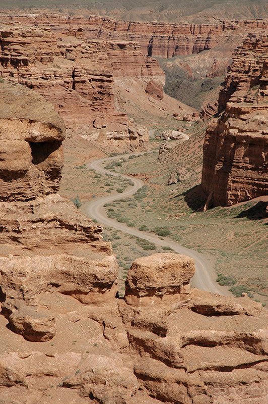
With the nearby border crossing closed, I have no alternative but to turn west once again, back to Almaty and the border crossing at Korday, where I had entered the country four weeks earlier. I stop en route to look at the dramatic Charyn Canyon, which drops down from the green mountain steppe in a beautifully eroded valley of red sandstone, highly reminiscent of the American south-west. The next day I drive to the busy border crossing of Qorday, thus completing a loop of almost six thousand kilometres over the last four weeks on the Kazakh Steppe.
I had entered Kazakhstan for the first time back in 2007, transiting along the eastern edge of the country to the most obvious points of touristic appeal in the south, with the impression that much of the rest of the country was empty, featureless steppe of no interest. On these two visits over the past eight weeks, during which I had crossed much of the country, it became clear that this widely-held impression of Kazakhstan is rather wrong. Indeed, as I explored the steppes and mountains of the country, with their traces of ancient history and magnificently beautiful and varying landscapes, it became perhaps my favourite in the region. With this large blank on my travel-map now reassuringly filled, I was prepared to make a final crossing of Central Asia, back to the Caspian Sea and on to Europe.
Stage 28 – Kazakhstan & Kyrgyzstan: The Kazakh Steppe [1/2]
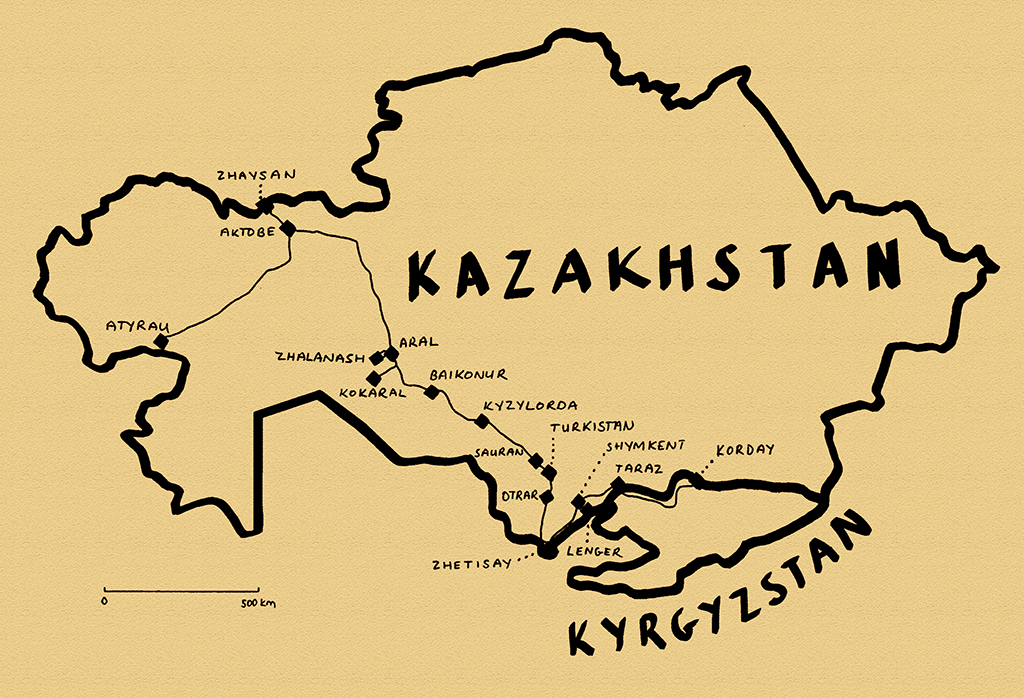
Between the great lowlands of Siberia and the long-settled oasis towns of Central Asia lies the Kazakh Steppe, almost wholly within the Republic of Kazakhstan, by far the world’s largest landlocked country. Larger than all of Western Europe and mostly covered with rolling grassland, I had twice made lengthy road journeys across firstly the east, and then the north of this country. I wished now to explore Kazakhstan more fully, rather than simply transit the country to some other, more obvious destination. Travellers often write-off Kazakhstan as lacking very much of interest, but in my seven weeks driving around this vast country I would discover the beauty, history and welcoming people which lie beyond the country’s main cities. Perhaps most rewarding however was the chance to indulge my love of wide, open spaces; feeling the freedom of moving independently around the steppe amidst lonely traces of ancient history.

Imangaly Mosque, Atyrau, Atyrau Region, Kazakhstan
It’s the 14th April 2011 and I enter Kazakhstan at the village of Zhaysan on the Ilek River, an arbitrary point on the wide, empty grasslands south of Orenburg. My arrival in Kazakhstan has coincided with the complete disappearance of winter snow-cover, replaced by springtime mud. The sudden presence of (albeit muddy) greenery after more than six months of winter monochrome is pleasant enough, but the feeling of being back out amidst the glorious endlessness of the steppe is more deeply soothing. I drive straight to the city of Aktobe, which I had visited with Karolina the previous year. Aktobe, which started life as a Russian garrison in the nineteenth century is a prosperous and upbeat place, but not a city that many people would purposely visit twice. Nevertheless, I spend a few days here relaxing before parking the truck in a secure car park (where there is a battered bust of Stalin hiding between parked cars) and take an overnight train to the city of Atyrau.
Atyrau, known as Guriev until 1992, is the centre of Kazakhstan’s oil and gas industry. What was once a windblown trading post on the delta of the Ural River, established by Russian merchants and preyed upon by Cossacks is now a city of gleaming, glass-fronted buildings and wide avenues choked by a level of traffic for which the city was never designed. Straddling the Ural River makes Atyrau technically a trans-continental city, but comparisons with İstanbul should stop there. In amongst the ministries and headquarters of international joint-ventures, an old city of crumbling early twentieth century housing shows that in the not-so-distant past the city was a forlorn fishing outpost eking out a living in this harsh and parched environment. It also hints at the inequality that such a sudden influx of wealth creates, leading to a rate of robbery unheard of in other parts of Kazakhstan.
Ural River, Damba, Atyrau Region, Kazakhstan
My host in Atyrau is Akmaral, a Kazakh from the north of the country who works as an interpreter for a large multinational, and so speaks excellent English. With a dry, British sense of humour perhaps picked up from colleagues and a hint of Russian melancholy; she’s excellent company, and shares Kabardine lamb and Dagestani brandy brought back from a recent trip to the Russian Caucasus. Also feeling something of a foreigner in this unlovable city, she explains that the locals in this arid western part of Kazakhstan are from a different zhuz (clan) and are rather ‘wild’, something we would both experience when I re-visited her later in the year.
The Ural River runs slowly through the centre of the city, having meandered its way across the steppe from its headwaters in the South Urals, a muddy and rather unappealing continental river on its way to the Caspian. I follow the river downstream to the road’s end at Damba where the river starts to braid. Here fishermen bearing forty-centimetre long carp buzz up and down the river in motorboats against a backdrop of endless reeds, filled with nesting birds. I’m somewhat disappointed not to reach the shore of the Caspian, which degenerates into a quagmire of mud at this time of year, but it’s nice to see (almost) the end of this river which I left in Orenburg last week, where it was a cascade of broken ice and tree trunks.

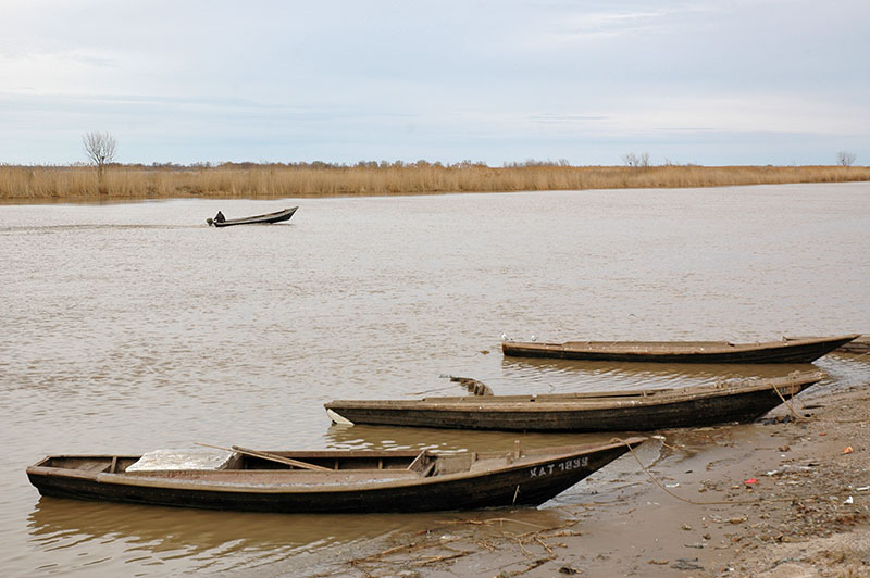
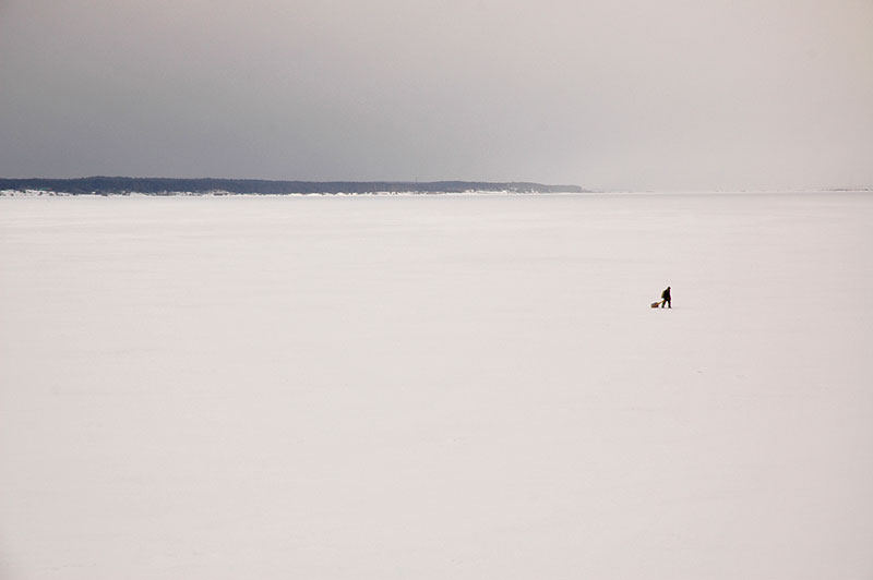
Beached Ship, Aral, Kyzylorda Region, Kazakhstan
I return to Aktobe on the train and head straight out of town on the arrow-straight road east, retracing my route from last June as far as the junction town of Qarabutaq, where I turn south-east. Here the road passes through steppe marked by very occasional, distant ridges of an ancient seabed, grazed by sparse herds of Bactrians seemingly roaming totally free. After several hundred kilometres I reach the outpost town of Aral. Once a prosperous fishing port on the Aral Sea, Aral’s decline was sealed by the Aral Sea Disaster which occurred due to the huge quantities of water siphoned off the Amu Darya and Syr Darya Rivers for irrigation, the sole feeders of the endorheic Aral Sea. Starting in the late 1960s the level of the Aral Sea fell disastrously, to the point where the sea was around one hundred kilometres from the former port of Aral. I’m surprised therefore to find Aral moderately busy, with an active bazaar and plenty of people on the streets. For sure, the town has seen better days, but here is not the same kind of hopeless desperation of Moynaq, a similar former fishing settlement on what was once the southern shore of the Aral Sea, in Uzbekistan. Nevertheless, Aral’s former harbour is completely dry, the docks are a wasteland of rusting steel and broken concrete with sentinel cantilever cranes and the only boats in sight are rather poignantly hauled up onto platforms as monuments to a departed and prosperous past.

North Aral Sea, Kyzylorda Region, Kazakhstan
I drive north-west out of Aral, past the remains of an airport, turning west and dropping down onto what was once unmistakably seabed. Low hills around me still bear tide marks down their sides as sad testament to the slow death of the sea. Passing the camel-breeding village of Zhalanash I drive a few kilometres south and stop for the night in a beautifully tranquil setting on the former sea bed. Around me are the remains of three boats, once brought here alongside several others in an attempt to save them from the receding water; efforts made in vain as their long-stricken position out on this salt-dusted desert shows. Yet even these memorials to Soviet environmental callousness have not been allowed a dignified end; their long-rusted hulls and superstructures having in many cases been cut up by scrap merchants for sale to China, just leaving these three skeletons.
In the morning I continue south on sandy tracks past salt pans, hoping to return to Aral via a circular route. It is here that quite unexpectedly I see patches of reeds, and then am truly shocked to see the Aral Sea, or rather, a small northern remnant of its former self, known as the North Aral Sea. Deep blue water stretches to a horizon marked by low dry hills and while very shallow, the sea has nevertheless revived the natural environment here, evidenced by the presence of two fishermen and abundant spent shotgun cartridges lying on the ground. After the rather melancholic sights of Aral and Zhalanash, stumbling by accident upon the sea, just twelve kilometres from Aral’s long-dry harbour, is quite uplifting. There has also been reported a moderation in the harsh local climate and a reduction in the wind-borne aerosols picked up from the dry sea-bed, which are the cause of many health problems for local residents. I return to Aral on a rough track, then rejoin the main highway south-east.

Fishermen, Kokaral Dam, Kyzylorda Region, Kazakhstan
After eighty kilometres I turn off the highway once again, passing the cerulean-blue waters of Lake Qamystybas, whose scrubby shores are grazed by motley-looking Bactrian camels. I pass a couple of small towns which are surprisingly good-looking in spite of their barren surrounds, then cross the thrashing waters of the Syr Darya River at a large sluice-gate, turning north on a dirt track to the southern shore of the North Aral Sea. From here it’s a short drive to the Kokaral Dam, a low concrete dike which is the reason that the North Aral Sea has come back from the dead. I surprise the security guards who keep watch over the dam in pairs and park up on the water’s edge, where I spend two very pleasant days camping. The Kokaral Dam is built near the outflow of the Syr Darya River into the Aral Sea Basin, and prevents water from escaping to the south, into the main body of what was once the sea. Thus the North Aral Sea is reborn at the expense of the southern portion which stretches into Uzbekistan. It’s a beautiful spot, with the deep blue water contrasting against the endless khaki colour of the desolate steppe. Groups of friendly fishermen are collecting the fish stocks which have returned in economically significant quantities. It’s a very pleasant place to relax, but even more beguiling for the genuine optimism which the returning waters of the North Aral Sea have inspired in local people.
As enchanting as the reborn Aral Sea is, I have an appointment to keep and so return to the main road, continuing my way south-east towards the long-settled southern reaches of Kazakhstan. Not far upstream from the Aral Sea lies Baikonur Cosmodrome, founded by the Soviet Union in 1955, launch site of both the first satellite and the first man into space, besides many others. Both the cosmodrome to the north of the highway and the service-town of Baikonur to the south found themselves part of an independent Kazakhstan following the breakup of the Soviet Union and are now leased by Russia, closed to outsiders without an invitation to enter. However, knowing that a launch is imminent, I park up on the highway overlooking the base. Winds are strong, and I wonder if a rocket launch will really take place, but on schedule to the second I see the distant, and surprisingly noiseless sight of an unmanned Soyuz Progress rocket lift-off on its way to re-supply the International Space Station. After less than a minute of steady climbing the rocket disappears into the sparse, high strata of cloud, leaving just a white exhaust trail from the ground. A brief but unforgettable sight.
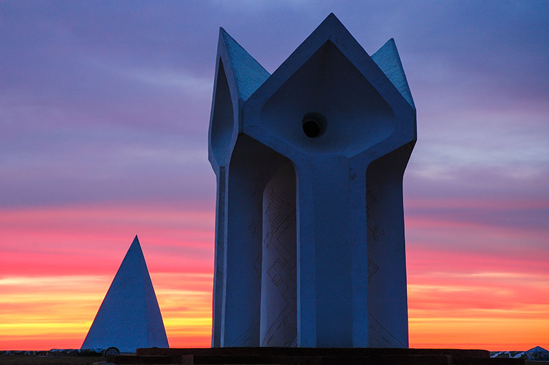
Korkut Ata Monument, Kyzylorda Region, Kazakhstan
A little further along the highway, as the sun is setting, creating a dusk of vivid orange and magenta, I pull in at the shrine complex of Korkut Ata. A legendary soothsayer and bard, Korkut Ata is known throughout the Turkic world in the ancient epic Dede Korkut, which describes the ethnic history, identity, customs and value systems of nomadic Turkic people. With its roots in the pre-Islamic Turkic societies of the steppe, the epic would have been passed on orally across the steppe for generations, only being written down as late perhaps as the fifteenth century. Korkut Ata is said to hail from the Syr Darya region and, at least in the Kazakh version of the legend, was a player of the kobyz, a traditional Kazakh instrument with two horse-hair strings and a goatskin resonating cavity. The centrepiece of the beautiful modern monument complex consists of four stylised, inverted concrete kobyz, sculpted such that the wind coming off the steppe is funnelled over a group of metal tubes to emit a doleful kobyz-like sound. Combined with the glorious atmospherics, I find this a highly enchanting spot and ask the site caretaker if I can sleep here. The friendly guardian, after initial confusion is very welcoming, though insists that I stay inside his simple house just outside the complex, rather than camp nearby. This genuine hospitality, as well as the knowledge that I am at the shrine of a great Central Asian mystic, make me feel almost like an ancient pilgrim on the Silk Road.

Ancient Grave, Kyzylorda Region, Kazakhstan
Kazakhs tell that Korkut Ata was plagued by a vision of his own demise at the age of forty and took to playing the kobyz to ward-off death, only to eventually become exhausted and die of a snakebite on the banks of the Syr Darya. In the morning I walk to the edge of the great river, known as the Jaxartes to the Ancients, its muddy waters heavily depleted by irrigation upstream in Uzbekistan and Tajikistan. Here there used to be a mausoleum to the sage, washed away in the twentieth century by a flood, the site now marked by a simple modern gravestone and some scraggly saxauls tied with colourful votive prayer rags. The surrounding area is dotted with graves, buried near the great man in the Islamic tradition; some quite ancient piles of stones, others collapsing mud-brick structures as ephemeral as the lives they commemorate. The fluted brick mausoleum of Korkut Ata’s favourite consort Aksakys sits nearby, needle-like on the steppe, a faux Persian tomb tower. It is in magnificent, tranquil places like these that one feels most keenly the culture of the Kazakhs and of the steppe, far away from the often rather vapid cities.
Not far beyond the monument complex the land starts to change, from barren steppe to irrigated farmland reminiscent of Sindh or the Lower Nile Valley, which is dusty and rather bland after the pristine steppe. I make an overnight stop in the city of Kyzylorda which was briefly the capital of Soviet Kazakhstan in the 1920s, but is of no immediate interest. The irrigated agricultural towns continue for several hours beyond Kyzylorda until the land abruptly reverts to virgin steppe; it is at about this point that I am funnelled into a natural corridor between the Syr Darya to the south and the Karatau Mountains to the north. This natural trade route marks roughly my re-entry to the historical heartland of Transoxiana (western Central Asia) with its maudlin remnants of a world-changing past.

Sauran, South Kazakhstan Region, Kazakhstan
Before long, to my right appear the mud-brick walls of the great city of Sauran, lying silent a few kilometres away in the steppe. Sauran controlled the very trade route which I am currently driving along and was an outpost at the edge of settled civilisation, surrounded by seven towering city walls and served by a Persian karez type of underground irrigation system. First mentioned in the tenth century, Sauran was invaded by Chinggis Khan (Genghis Khan) and later became the capital of the White Horde under one of his grandsons. Timur (Tamerlane) took over the city in the fourteenth century, turning it into a fortress. However, as the nearby city of Yasi (Turkistan) grew in importance, Sauran’s prosperity waned and it was permanently abandoned in the nineteenth century. Today, Sauran’s heavily eroded walls, which hover on the grassy steppe, are perhaps Kazakhstan’s most evocative sight, speaking of the decay of Central Asia in the same way as the ruins of Balkh or Merv; of transient splendour slowly washing back into the earth. I have the entire city to myself and explore the remains of the thick perimeter walls, in places up to seven metres high and heavily eroded, walking among excavated tiles and stumps of walls, over ground still strewn with pottery shards, a ghost of thousands of lives lived, now forsaken by the outside world.
I stop the next morning in Turkistan, home to the shrine of the twelfth century Sufi mystic Khoja Akhmet Yassawi and one of the most magnificent pieces of Timurid architecture, at the sight of which I was rapt during my first visit in 2007, close to the beginning of the Odyssey. Seeing the glowing faïence of the shrine’s gorgeously fluted dome at the end of a torrid July day was one of my most formative experiences of Central Asia. I don’t wish to overwrite my initial memories however, so after a brief re-acquaintance with the site, I move on. Not far beyond Turkistan I turn south off the highway, towards the confluence of the Arys and Syr Darya Rivers, where lies the Otrar Oasis.

Otrartobe, South Kazakhstan Region, Kazakhstan
If Sauran is a romantic ruin of the past, then Otrar stands as a testament to a bitter lesson in history. Lying at a node of Eurasian trade routes, on the border between settled and nomadic civilisations, the Otrar Oasis has been settled since at least the sixth century, and in the past consisted of a number of individual settlements. Known before the thirteenth century as Farab, Otrar would have been a centre of Turkic culture and it is considered by many to be the birthplace of Al Farabi (Alpharabius), one of the greatest medieval polymaths and poets. In 1218, Otrar’s ruler, Khorezmshah Mohammed II, received news of an trade envoy sent from Chinggis Khan, a man he refused to treat as an equal, and sorely underestimated. He sent his governor Inalchuk out to rob, then arrest the leader of the envoy, who was finally put to death. This was to prove a fateful moment in history; for it was the following year that Chinggis Khan unleashed the fury of the Mongols upon Central Asia, later reaching as far as Arabia and Eastern Europe. After a five month siege, the oasis was razed to the ground and all its citizens slaughtered. Otrar was to recover in parts, until its final demise in the late eighteenth century, but never to its earlier extent. Otrartobe, the main archaeological site of the oasis, is now a vast pile of the detritus of civilisation, its collapsed earthen walls glinting with the white of broken bones and blue ceramic fragments.

Steppe, near Shardara, South Kazakhstan Region, Kazakhstan
South of Otrar I cross to the left bank of the Syr Darya and follow the river upstream on a road which soon looks as if had also been left to decay since the thirteenth century. These are the fringes of the Kyzyl Kum Desert, a desolate landscape dotted by occasional, desperate-looking fly-blown settlements. In places the track is so faint as to be hard to discern against the steppe, but before too long asphalt returns and I’m driving through a green, irrigated area towards the southernmost point of Kazakhstan. Reaching the large Shardara Reservoir, I cross the river again and drive east across beautiful, rolling green grasslands dotted with shepherds on horseback tending flocks of sheep, quite unexpected given the proximity of the desert. My destination is the small, modern cotton-processing town of Zhetisay, located in a salient of Kazakhstani territory surrounded on all sides by Uzbekistan. Zhetisay is a dull country town, but I have the good company of my host Katherine, a Peace Corps volunteers, and her affable Russian landlord Yura, who is only too pleased to help me finally fit the new front springs onto the truck, which I’ve been carrying for more than two months since leaving Estonia.

Bazaar, Shymkent, South Kazakhstan Region, Kazakhstan
I stay a few days in Zhetisay where the summer heat is already building before resuming my eastward journey, tracking the border with Uzbekistan past the chaotic border crossing which I used almost four years ago, named rather romantically ‘Zhibek Zholu‘, or simply ‘Silk Road’. I stop in Shymkent, a slightly gritty, industrial city and the largest in southern Kazakhstan, where I am hosted by Kanat, a self-made businessman who spends his days checking up on various concerns of his and has built a large house for his extended family, acting as the head of the house in place of a father. I share a room with Kanat’s nineteen year-old brother who has recently decided to become a pious Muslim, though seems to be having trouble waking up in time for the dawn prayer. Kanat is openly disapproving of his brother’s newly found faith, dismissing it as something of a fad; an opinion I would often hear from older generations in Kazakhstan concerning the visible increase in religious posturing of the country’s youth.
Shymkent was founded in the twelfth century in the shadow of nearby Sayram and became a trading post between Turkic nomads and settled Sogdians. Aside from its heavily polluting lead smelters, modern Shymkent remains a bustling market city, more of a metropolis than most of the country’s provincial capitals, but it lacks singularly any visible evidence of its long history. It is still however a city based around trade and its bazaar is one of the biggest in the country with a range of goods from the farmland to the south and pastures to the north, and a range of faces reflecting both settled and nomadic ancestries.
Sayram, less than twenty kilometres from the centre of Shymkent is perhaps the oldest surviving city in Kazakhstan and one of the oldest in Central Asia; a relaxed country town populated almost entirely by ethnic Uzbeks and free from any Soviet urban architecture. As might be expected in such a long-settled place, Sayram is full of cemeteries and mausolea, including those of the mother and father of Yassawi (who was born here), drawing a steady trail of pilgrims. I’m not quite sure what to make of Sayram however; at once it’s a tranquil rural town with far more character than most of Kazakhstan’s settlements, whilst simultaneously being very obviously a shadow of its former self and lacking any particular focus. After visiting the visually unremarkable mausolea, I content myself with a brief wander along winding lanes, then head south towards the green mountains.

Tulipa greigii, Sayram-Ugam National Park, South Kazakhstan Region, Kazakhstan
It’s not far from Sayram to the small town of Lenger, which though rather nondescript, is in an appealing setting of rolling green hills, backed by the snowcapped Ugam Mountains to the south; quite unlike anywhere I have been in the last few weeks. I’m hosted here by Serik in his spacious family home, where he lives with his wife and son. Serik is not part of the urban business class, or an employee of a multinational, but he has single-handedly taught himself English and through his generosity in opening his home to travellers, gives me a touching insight into rural life, a pleasant change from staying in the generally bland cities.
The following day I drive out of Lenger into the hills, reaching a road-head in the recently-established Sayram-Ugam National Park, where I leave the truck and strike out on foot. An outlier of the Western Tien Shan, here forming the border with Uzbekistan to the south, the slopes of the Ugam Mountains are a gorgeous carpet of emerald green grass, still filled with snow in creases and gulleys and dotted with dark green dwarf pines. I walk for a few strenuous hours up into the mountains, reaching a broad saddle still covered in deep winter snow, with magnificent views west across buckling foothills which soften into flat steppe in the far distance.
Just as enchanting as the views is the native flora; from wild apple-blossoms in the valley floors, to a beautiful range of wild tulips which dot the mountainsides. Some, such as Tulipa kaufmanniana have bright yellow, elongated petals and look quite unlike commercial European varieties, whereas others such as the beautiful Tulipa greigii have the iconic bulbous flower-head which caused so-called ‘Tulip Mania’ in seventeenth century Holland. It is however here, in these flower-dotted grassy hillsides of the Tien Shan that the tulip originates.

Kazakh Man, Taraz, Jambyl Region, Kazakhstan
It’s two hundred kilometres to my next stop; the city if Taraz, founded two thousands years ago, devastated by the Mongols in the thirteenth century, only returning to prominence in the early nineteenth century when re-settled by the Khanate of Kokand, and taken by the Russians not long after. Taraz has a nicer atmosphere than Shymkent and is also a bustling market city, as it was in ancient times. With a pair of restored Karakhanid mausolea, and extensive archaeological remains of the pre-Mongol city preserved in the modern centre, there is for once a palpable air of longevity about the place. Previously known as Talas (after the nearby river), from where its current name obviously derives, Taraz is perhaps most noteworthy for being the approximate site of the 751 CE Battle of Talas, in which the armies of Tang Dynasty China was routed by the Arabs (allied with Tibetans), thus keeping Chinese influence out of Transoxiana and establishing Islam as the dominant cultural force. In addition to the immediate, regional impact of the defeat, wider reaching effects included the wane of Buddhism in Central Asia, isolating it from its Indian base and fostering the development of the current, Mahayana schools of northern and eastern Asia, and the import of paper-making to the Middle East, from where it later spread to Europe.
One of the conditions of my two-month long Kazakhstan visa requires me to leave the country within thirty days, and re-enter in order to continue my stay. Thus after two days I leave Kazakhstan from the border crossing with Kyrgyzstan which lies just beyond the outskirts of Taraz, where indeed the great battle may well have taken place. As a result of a recent joint agreement between the two countries, I am able to enter Kyrgyzstan with my visa for Kazakhstan, though the suspicious Kyrgyz border guard seems never to have heard of it and I’m only stamped into the country after calls are made to superiors.

Suusamyr Valley, Chuy Region, Kyrgyzstan
Kyrgyzstan is noticeably quieter than Kazakhstan and the landscape immediately becomes more mountainous. I pass the Kirov Reservoir, where a giant face of Lenin has been cast in concrete onto the mountainside, and begin climbing in an easterly direction up the valley of the Talas River. At first the landscape is agrarian, the road lined by small farming communities, but shortly after passing the small, modern provincial capital of Talas, I enter the high, rolling grasslands as the road winds up towards the snowcapped peaks of the Tien Shan. Crossing the 3300-metre Ötmök Pass, I drop down onto the M41 Highway which runs south through the Pamirs to the Amu Darya and Afghan border; surely one of the world’s most beautiful roads. I turn north however, back towards Kazakhstan and descend slowly into the utterly glorious Suusamyr Valley, a broad, grassy plain dotted with Kyrgyz yurts and backed in the east by the gorgeous, smoothly snowcapped peaks of the Tien Shan. I had driven this road almost four years earlier in August 2007, but seeing it now with the grass greener and the snow thicker, it seems even more enchanting than before.
The Suusamyr Valley section of the M41 ends with a steep climb to the 3180-metre Töö Ashuu Tunnel, bored three and a half kilometres through a mountain, then descends steadily to the Chuy Valley. It’s late in the evening before I reach Bishkek, where I turn north to the busy border with Kazakhstan at Korday. Here, after several hours of delays and searches by official most likely waiting for a bribe, I am stamped back out of Kyrgyzstan, concluding my sixteen hour visit. Ahead of me awaits three more weeks of travel on the huge Kazakh Steppe.
Stage 27 – Russia: To The Urals
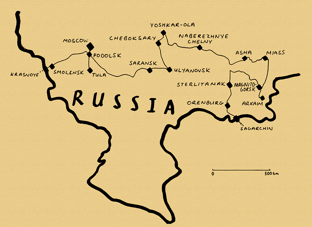
It was only in the twentieth century that the Urals, a chain of low and very ancient mountains running approximately 2500 kilometres from the Kara Sea in the Arctic to the steppes of northern Kazakhstan, became the most widely accepted convention used to define the notional boundary between Asia and Europe. As a result, these mostly unspectacular but soothingly beautiful mountains demarcate no great physical or cultural divide in the Eurasian continent, representing only a subtle transition to the great wilderness of Siberia. Up against the western flanks of the Urals however live a patchwork of non-Russian nations, descendants of the region’s aboriginal inhabitants, now assimilated to varying degrees into contemporary Russian society. This stage of the Odyssey would take me from the western frontiers of Russia through this chain of federal republics strung along the Upper Volga River, into the forested ridges and industrial cities of the South Urals and on to the edge of the Kazakh Steppe. As the long Russian winter finally eased its grip on the land, my 4500 kilometre eastward journey to the edge of Central Asia would complete a fascinating year spent travelling in and out of Russia.

Mass Grave, Katyn War Cemetery, Smolensk Region, Russia
It’s the 19th March 2011 as I enter Russia from Belarus with nothing more than a cursory check of my vehicle registration document from a traffic police officer. As if to confirm my re-entry into Russia the weather, which in Belarus had been showing signs of impending spring, reverts firmly back to winter with snow falling steadily as I drive through stands of mixed forest towards the city of Smolensk. Turning off the main M1 highway in the early evening, I stop in one grimly notorious patch of forest just outside the village of Katyn. Here, in 1940 the NKVD, predecessors of the KGB, murdered approximately 22,000 Poles, both army officers and civilians, in what became known as the Katyn Massacre. To compound this genocidal act, the Soviet authorities long blamed the Nazis, who came across the mass graves early in 1943.
After spending a cold night in the forest, I am the first to enter the memorial site in the morning. Here, beyond a small museum complex, amidst beautifully tranquil pines, walkways pass mass graves, marked by crosses and huge steel-plated memorials bearing the names of some of the deceased. It was not until 1990, following glasnost, that the USSR finally admitted their guilt in the massacre. Katyn represents not only a war crime, but is typical of the kind of official falsification of history which was routine in the USSR. In a country where people seldom reflect on the darker episodes of a brutal past and have been taught a history edited to fit both Marxism and Soviet propaganda, the Katyn Massacre is a rare example of the open revision of Soviet historiography.

Assumption Cathedral & Trinity Monastery, Smolensk, Smolensk Region, Russia
A little later in the morning I arrive in Smolensk, which despite the cold, damp weather, I soon judge to be one of Russia’s lovelier cities. Smolensk is set amidst rolling hills astride a young Dnieper River and despite its strategic position on a logical route from central Europe, feels like a gently time-worn backwater. Walking north on Soviet Street, down towards the river through the falling snow, I have in front of me a scene which could be the subject of many a Russian watercolour. My eye is lead down a curve in the street, lined by bare trees and damp, pastel yellow nineteenth century buildings. Beyond the roofs of these lie first the rather plain Trinity Monastery and then the peppermint green of the exuberant, Renaissance-inspired Assumption Cathedral, unusually square in plan with three large porthole windows on each soaring slab-wall. This unusual piece of Russian church architecture took more than a century to complete and according to local legend, was spared harm during Napoleon’s disastrous 1812 invasion of Russia, with the French Emperor threatening to personally kill any man who dared desecrate it.
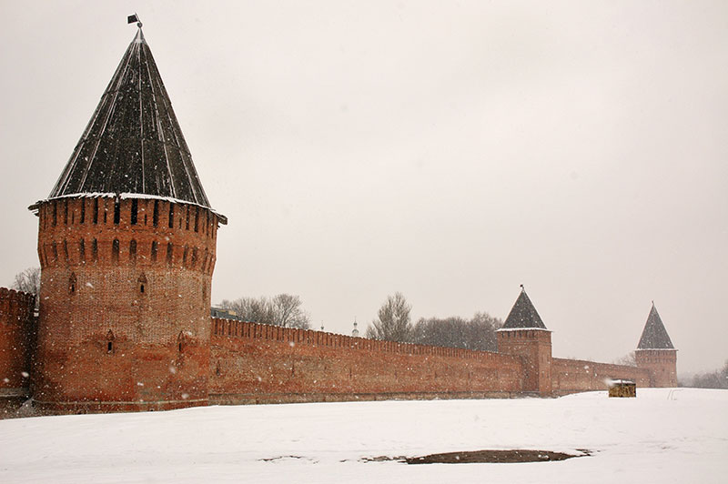
Kremlin, Smolensk, Smolensk Region, Russia
As might be expected of a large and ancient city on the frontiers of a huge empire, Smolensk has a long history of invasion and destruction, having twice slipped beyond the frontiers of the Russian state. Nevertheless, as I walk downhill into one of the city’s small valleys, attractively dotted by dark brown timber houses with colourful wooden-framed windows, I am surprised to find a huge and magnificent sixteenth century kremlin (fortress) looming out of the falling snow on the opposite hill. It’s a beautiful structure with long red-brick walls and defensive towers of alternately square and round in plan, covered by steeply pitched wooden roofs; a real icon of Russian defensive architecture and a symbol of Russia’s western defences. The modern centre of Smolensk somewhat less remarkable, with tall and imposing Stalin-era city blocks, parks celebrating the important role of the ‘Hero City’ during the Second World War, and a grandiose philharmonic hall named after the composer Mikhail Glinka, the father of Russian classical music, who was a born in the city.
As charmed as I am by Smolensk however, I opt to leave in the afternoon, heading east towards Moscow – a city I have very little affection for – in order to visit the Embassy of Tajikistan the following morning. The thought of driving into the vast congested sprawl of Europe’s largest city leads me to stay instead in the satellite city of Podolsk, a rather dull industrial city which is separated from Moscow’s sprawl by just 500 metres of open land. I am hosted here by Katya, a student with impeccable English who lives with her parents in their self-built house, in a slightly unusual middle-class suburbia. My visit to the embassy annoyingly coincides with Nowruz celebrations in Tajikistan, meaning I have to wait several days to see the consul. I spend a day relaxing at home with Katya’s father who is a carpenter and seems grateful for some male company; together we drink beer and watch ‘White Sun of the Desert‘ a classic Soviet film of a chivalrous Red Army soldier set in the deserts of Central Asia during the Russian Civil War. It’s refreshingly free of Soviet propaganda, an innocent and timeless film seen by virtually every citizen of the Former USSR.

Assumption Cathedral, Tula, Tula Region, Russia
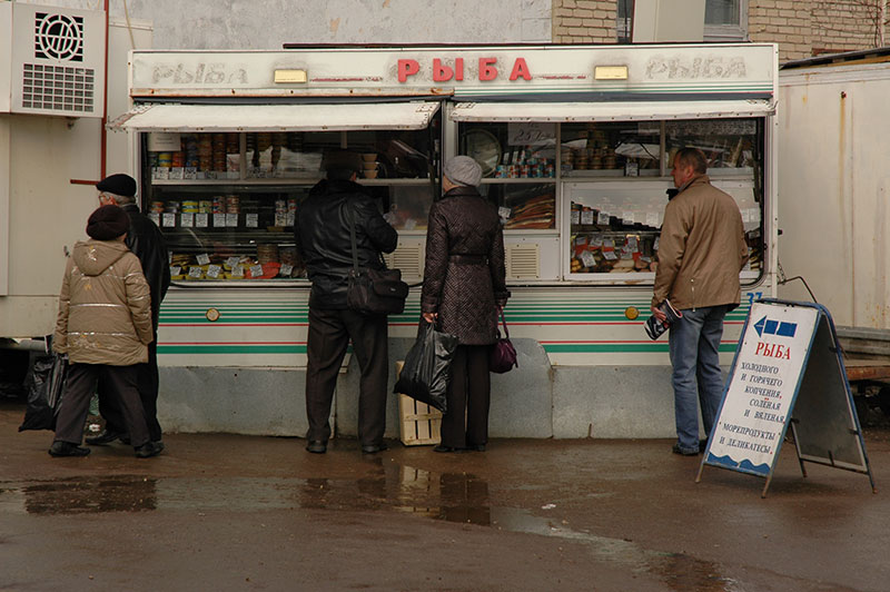
I make an excursion from Podolsk to the city of Tula, leaving the truck at Katya’s house and taking an elektrichka, (a short-distance intercity train). The train journey offers an interesting glimpse of Russian society. As we pull out of what are effectively suburbs of Moscow, the train is full of a rag-tag bunch of students (who run from one carriage to the next at each stop to avoid paying the fare), workers and all-sorts. Dark, gypsy-faced Tajiks from around Samarkand pace the train selling fruit; other hawkers sell clothes, toys and other low quality Chinese-made items. We roll through utterly bland, inconsequential satellite towns of Moscow Region, which become ever less prosperous looking. At some point, beyond reasonable commuting distance the towns break into the familiar, unending Russian countryside dotted by occasional damp, tumbledown villages which could be anywhere in the country. The train empties of students and commuters, leaving a crew mainly of drinkers; lone fishermen who board unsteadily at small, half-deserted stations along the line. Here is a peculiar type of Russian drifter; fairly clean-looking, if pallid of face, well spoken, conversing with his neighbour in a string of expletives known as mat (which is at one eloquently poetic and obscene) but whose frayed clothes reveal the underlying poverty and social decay which he represents.
Market, Tula, Tula Region, Russia
Tula, 180 kilometres south of Moscow is somewhat less attractive than Smolensk. Despite an striking central kremlin housing the beautiful, gold-domed Assumption Cathedral, Tula’s centre feels rather sprawling and its proximity to the capital seems to have infected the city with a rash of unplanned, ugly modern buildings and an excess of advertising boards on every street. Like Smolensk, Tula was one of the Soviet Union’s twelve ‘Hero Cities’; and the heroics and hardware of the forty-five day siege in which the city held out in the winter of 1941, defending Moscow from the south, are remembered in a surprisingly modest Victory Park. Other parts of Tula are quite shabby; walking towards the city’s busy market I descend a street of decrepit wooden houses; a few appear to be well maintained, while others have been deliberately burnt by property developers – the fate of many wooden structures across Russia – in order to build modern houses and thus ruin the aesthetics of an entire street. I also come across the large, wooded All Saints Cemetery which is both a picture of decay and ruin, and an intriguing timeline of Russian history. Ornately carved eighteenth century tombstones sink slowly into the snowy ground; small nineteenth century obelisks lean gently, and twentieth century secular steel grave markers with red five-pointed stars slowly rust away. My favourite however is a memorial to soldiers of the Second World War; a brutal piece of Socialist-realism executed in coarse, rendered concrete which somehow manages to be quite delicately moving in its portrayal of an unknown, falling Red Army soldier.

War Memorial, Tula, Tula Region, Russia
Back in Moscow I manage to enter the consular section of the Tajikistan Embassy and join a truly unimaginable scrum of people all shouting and waving towards a counter at the far end of the room. Never have I seen such a crush of humanity; these are desperate migrant workers collecting documents in order to renew their residency in Russia; something they must do monthly in order to send back money earned in tough, menial jobs to their impoverished home country. I push through the crowd shouting ‘visa!’ and over the course of several minutes – at one point with a small boy clinging to my leg – I make it a few metres to a door where I am glad to be whisked into the calm of the back-offices. The visa process is a sham, and I end up bargaining with the consul as if I were buying an antique rug, arguing the price according to duration of stay and number of entries. I get a three month, double entry visa for 120 US Dollars, the consul puts the money in his pocket, and I walk out with a visa in my passport. Simple and efficient.
Long ago, before the massive Russian expansion into Siberia, Central Asia and the Caucasus in the sixteenth to eighteenth centuries, the embryonic Russia state expanded from its heartlands around Kyiv, Novgorod and later Moscow into territories populated by indigenous Finno-Ugric peoples and Turkic peoples who had themselves migrated fairly recently from the east and south. Today a multitude of federal republics exist along the upper Volga and around the Urals; ostensibly home to these various nations, some of whom are culturally and linguistically severely endangered.

Seat Of Government Building, Saransk, Mordovia Republic, Russia
Driving east from Podolsk, away from the orbit of Moscow, past the city of Ryazan which was the first to bear the thirteenth century invasion of the Mongols, I am in the Republic of Mordovia by early afternoon. I drive through a blizzard shortly after leaving the main M7 highway and turning north-east towards Saransk, the capital of the republic; it might be late March, but I am still within the depths of winter, which has lasted for around five months so far. I reach Saransk after dark, and am hosted by Stas and Larisa, a couple of young Russian journalists. Mordovia is named after the Mordvin people, a Finno-Ugric nation distantly related to Finns, Estonians and Hungarians. The Mordvins are split into two main groups (indeed the term ‘Mordvin’ may well be an exonym); the Moksha and the Erzya, and like all Finno-Ugric peoples in Russia, they have been heavily russified and are highly assimilated into contemporary Russian society. Although the Mordvins are quite numerous, their language is endangered and little-used by the urban population; their original animistic religion has been largely replaced by Orthodox Christianity and in dress and appearance they are not readily distinguishable from Russians. Indeed, there are no outward signs that Saransk is anything other than a small, if quite pleasant Russian city; only the striking late-Soviet Seat of Government building hints that this is the capital of an autonomous republic in anything more than name.

Wooden House, Ulyanovsk, Ulyanovsk Region, Russia
From Saransk I drive due east through a beautiful wintry landscape of gentle, low hills and patches of birch forest, until I reach the Volga in the city of Ulyanovsk. Established as Simbirsk, a fort during the eastern expansion of Russia in the seventeenth century, it was renamed after its most famous resident; Vladimir Ilyich Ulyanov, better known as Lenin. In Soviet times ‘Old Simbirsk’, which amounts to the area immediately around the house in which Lenin was supposedly born, was something of a pilgrimage site, but today its draw is very much diminished. Indeed, I’m surprised to find just a simple street of wooden houses rather than any of the heroic gigantism of which the Soviets were so fond. Aside from Old Simbirsk, Ulyanovsk is a slightly noxious industrial city, albeit with a certain gritty charm and a magnificent view over part of the Kuybishev Reservoir which turns the Volga into a huge expanse of frozen water, stretching in some directions to the horizon.
Assumption Church, Cheboksary, Chuvash Republic, Russia
Driving north-west from Ulyanovsk, I cut across the inside of a large bend in the Volga to reach the city of Cheboksary, several hundred kilometres upstream. Cheboksary is the capital of the Republic of Chuvashia, and I am hosted in the city by Dimitry and his family, who are Chuvash. The Chuvash are of Turkic origin, thought to be descendants of the Volga Bulgars, ad-mixed with indigenous Finnic tribes. The Chuvash are spread widely across this Volga – Ural region and many cities here have their own separate names in the Chuvash language, which branched off long ago from the Turkic language family, is unintelligible to speakers of any other Turkic language, and is closely related only to extinct languages such as Bulgar or Khazar. Unlike the neighbouring Mordvins or Maris, the Chuvash are a majority in their titular republic, regularly use their own language (which is nevertheless considered endangered due to the dominance of Russian), and generally seem more culturally robust. Dimitry speaks to his mother and father in Chuvash, and tells me that there are villages not so far away where people speak only Chuvash, which I find reassuring in the face of centuries of russification efforts.
Volga River, Cheboksary, Chuvash Republic, Russia
Cheboksary, named Shupashkar in Chuvash, was established as a Russian city in the mid-sixteenth century, on the site of what was most likely an earlier Bulgar settlement. Dimitry shows me around his native city which is attractively sited on the right bank of the Volga, here an endless white plain across which a few souls make the three kilometre hike from the opposite bank while large snow-clouds move in from the east. Unusually for a Turkic nation, the Chuvash are largely Orthodox Christian (with a minority following the traditional Chuvash animist religion) which results in a proliferation of churches in the city, especially in the now frozen Cheboksary Bay area, though all are purely Russian in style (and rite). While there is nothing in Cheboksary’s urban architecture which obviously distinguishes its non-Russian character, there is nevertheless at least something palpably vital about the Chuvash culture, lying somewhere between the near assimilation of the Mordvins, and the outright cultural assertiveness of the nearby Tatars.

National Art Gallery, Yoshkar-Ola, Mari El Republic, Russia
Just east of Cheboksary I drive across the Volga and am immediately in the Mari El Republic. The Mari, together with the Mordvins, are the only surviving Volga Finns (other such as Murom, Merya and Meshchera are now extinct) and like the Mordvins are heavily assimilated. Driving north from the Volga I soon reach the capital Yoshkar-Ola, where I find, as in Saransk, no real sign of Mari language or culture. Indeed, the republic’s president, an ethnic Russian, has been implicated in the closing of Mari language newspapers and the repression of Mari leaders, rights groups and the traditional Mari religion.
I’m shown around Yoshkar-Ola by my Russian host Yulia and am bemused to find a rash of new buildings which remind me of the vulgar urban construction projects favoured by Central Asian dictators. The most striking of these is the mechanical clock on the outside of the National Art Gallery, a garishly coloured and incongruous piece of Venetian Gothic on the city’s central square. As the clock chimes the hour, the Virgin Mary appears in an upper door on the large, square clock-face. Piped choral music begins, and a donkey walks a semicircle with unbending legs from one lower door to another, with Mother and Child finally appearing in the opposite upper door. The whole display lasts over three minutes, during which I fail to conceal my laughter at its crassness. This rash of new development spreads along the banks of the Kokshaga River which runs through the city, and although this does give the capital of Mari El a certain distinctive character, it is in no way representative of Mari culture, reeking instead of being a pet project of the president (no doubt enriching certain of his cronies) which is of no use to the general populace of an economically stagnating region.
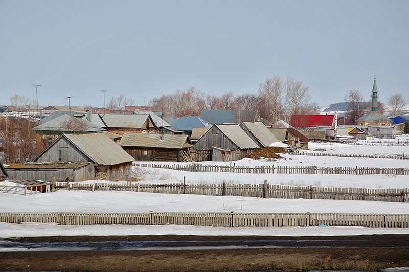
Asyanovo, Bashkortostan Republic, Russia
Perhaps however, I am being a little naive in expecting to find a series of truly federal republics of different nations living side-by-side. Indeed, what is really more impressive is the fact that these nations – and many others – are blended with the Slavic ancestry of Russians to create the very essence of the Russian nation, whose genome reflects the territorial growth of Russia over the last millennium and shows the true meaning of racial integration.
From Yoshkar-Ola I rejoin the Volga and make some real progress east, through the comparatively distinctive republics of Tatarstan and Bashkortostan; two Turkic nations descended from the Volga Bulgars, both of which have strongly preserved their language and individual cultures. Here Russia begins to change noticeably; mosques start to appear in the villages of colourful wooden houses, where dwellings are clustered around each other more haphazardly in closer communities, as in much of Asia. Physically, the gently undulating fields and woodlands of European Russia start very gradually to gather into ridges and, almost imperceptibly, I enter the ancient folds of the Urals. The M5 highway, Russia’s main road artery into Siberia narrows to single lanes and becomes choked with lorry traffic as it winds across the low, forested mountains, so as I enter Chelyabinsk Region, I turn off and continue on a series of backroads which wind through the small towns either side of the highway.

South Urals, Verkhny Katav, Chelyabinsk Region, Russia
I make my way east stopping first in Asha, an iron mining city which is beautifully set below steep mountains, with tall outcrops of banded pink and grey limestones running to Minyar, along the Trans-Siberian mainline. Rejoining the highway briefly I pass above the town of Sim which spreads across the snowy landscape in rows of colourful low houses and is the birthplace of Igor Kurchatov, father of the Soviet atomic bomb. Soon after I turn south towards the highest peaks of the South Urals, topped by Mt. Yamantau which can be seen from the road’s end at Verkhny Katav, still completely covered in snow. Further east the land climbs into uplands and a rather indeterminate Europe – Asia border, through more mining and metal-working towns such as Yuryuzhan, Satka and Zlatoust, all established in the eighteenth century to take advantage of the abundant mineral riches of the Urals. The landscape alternates between quaintly colourful lake-side towns and grim, crumbling factories belching smoke from filthy towers into the beautiful landscape.

South Urals, near Miass, Chelyabinsk Region, Russia
I stop in the city of Miass, a centre of copper and gold extraction, which is set amongst beautiful mountain scenery. The weather is well above zero and although the crystal-clear waters of Lake Turgoyak are still frozen, with ice fishermen sitting patiently next to their small holes, the surrounding hillsides are yellow with recently exposed grass, and the lakeside pines add some green to a landscape which for months has been a winter monochrome. With my host Sergey I walk up a steep hillside on the eastern side of Miass, through snow-filled forest and onto a broad ridge of basalt dotted with still-bare larch trees. To the east is lake-dotted Ilmen National Park, marking the beginning of Siberia and an inconceivably huge wilderness. To the west a succession of low ridges fade away into the afternoon sky, marking at some point the boundary between Asia and Europe. This quasi-continental divide is in reality, merely a political and cultural concept; a modern-day expression of an ancient Greek conceit. Here it seems faintly ludicrous to call this low and ancient mountain chain deep in the Eurasian continent a cultural boundary between west and east. None of this of course detracts from the beautiful views all around, with the warm air and slightly milky skies suggesting the onset of spring.
I leave the city heading south, past the Miass pond, on the frozen surface of which children are skating and playing ice hockey, backed by colourful, pitch-roofed wooden houses; a slightly timeless scene which might be a century-old oil painting. I cross the M5 one final time, leaving Siberia for a future trip and drive south on a series of small roads, keeping the Urals to to my right, weaving in and out of Bashkortostan. Large rain-bearing clouds sit just above the mountain peaks as I pick my way through Bashkir villages with beautiful wooden mosques, combining traditional Russian wooden architecture with simple octagonal minarets. I’m driving roughly along the Ural River, which here demarcates the Asia-Europe border all the way to its endpoint at the northern edge of the Caspian Sea.

Magnitogorsk Iron And Steel Works, Magnitogorsk, Chelyabinsk Region, Russia
More than 150 years after the Tsarist Russian government started to exploit the mineral riches of the South Urals on a large scale, the area saw a second wave of industrialisation during early Soviet times, boosted especially by both the demand for raw materials and the Nazi threat itself during the Second World War, which caused many industries from European Russia to be relocated here, well away from the front. My next stop is a perfect example of such development; the city of Magnitogorsk. Located on the Ural River, Magnitogorsk was established as part of a system of forts along the Russian frontier, but the potential riches of nearby Magnitnaya mountain were soon realised, and ore extraction began in 1739. Later, Magnitogorsk became the industrial showpiece of Stalin’s five-year plans of the 1930s, which brought in experts from the US and Germany to make up for a lack of local knowledge in building the gargantuan Magnitogorsk Iron And Steel Works, until Stalin’s paranoia grew to the extent that the city was declared ‘closed’, and foreigners expelled in 1937. Today, despite the exhaustion of ore reserves in Magnitnaya Mountain, the metal works occupies the entire left bank of the Ural as it flow through the city; a hideous panorama of smokestacks belching multifarious colours of noxious fumes, so grim as to be quite morbidly attractive. The huge Tyl Frontu monument, consisting of two metal workers holding aloft an enormous sword occupies a promontory over the river from where the metal works may best be viewed and stands in remembrance of the efforts made by workers behind the front line, particularly important for the supply of Red Army tanks.
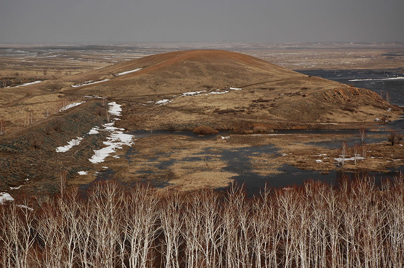
Arkaim, Chelyabinsk Region, Russia
Metallurgy in the Urals is far from being a modern activity, and out in the sparsely populated steppe where the Urals, the Eastern European Plain and the Kazakh Steppe all come together, a series of archaeological sites of the Sintashta Culture show that metal production was prolific here in the Bronze Age. Far more interesting however are the similarities between burial practices observed by archaeologists here and those described in the Rig Veda, the oldest Indian religious text (in fact the world’s oldest religious text). It is therefore hypothesised that the Sintashtans were speakers of Proto-Indo-Aryan (which may itself have been influenced in part by local Finno-Ugric languages), and may have been a stepping-stone on the migration of the Indo-Aryans from the Lower Volga region to the Indian Subcontinent and Mesopotamia. The best preserved Sintashta site yet discovered is Arkaim, around 150 kilometres south-east of Magnitogorsk. Leaving the Ural River, I drive out into the steppe; that endless expanse of rolling grassland which I find so comforting, past forgotten small towns and villages to reach Arkaim, only to find the area flooded, and the site itself inaccessible. Nevertheless, climbing a nearby ridge I get a good view over the site. It’s truly fascinating to think that these people, from this barren and forgotten area, may have gone on to seed one of the world’s great civilisations, pre-cursors also to many of the cultures through which I have travelled for the past four years.
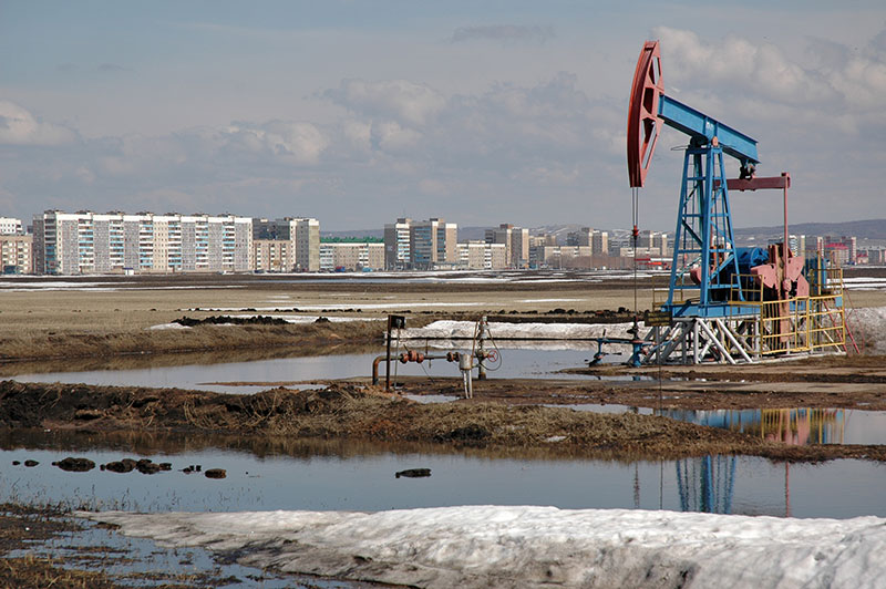
Oil Well, Salavat, Bashkortostan Republic, Russia
I make a final crossing of the South Urals, heading east from Magnitogorsk through the Bashkir towns of Abzakovo and Beloretsk, where low cloud boils over the mountains, then through beautiful forest-covered hills, where bare, wispy birch trees grow amongst occasional green sprigs of pine, revealing the snow on the forest floor. After several hours of this glorious scenery, I emerge in farmland just south of Ufa and turn south, passing through the industrial cities of Sterlitamak, Salavat and Kumertau. As I progress southwards, the snow-cover recedes and I enter the yellowish steppe, leaving behind both the winter and the mountains.
My last stop in Russia before entering Kazakhstan is Orenburg. Rather whimsically, the name of this city had long been in my mind and for no other reason I was keen to visit. Orenburg was in fact the name of several settlements initially named after the Or River. The first became the city of Orsk, around 250 kilometres to the east; the second was destroyed, and the current Orenburg is in fact the third incarnation of the city. Established as a frontier fort for Imperial Russia’s expansion into Central Asia, Orenburg lies off the country’s main road and rail conduits, out on the fringes of the windswept Kazakh steppe, though its gas industry and large student population neutralise any forlorn or frontier atmosphere that one might anticipate.
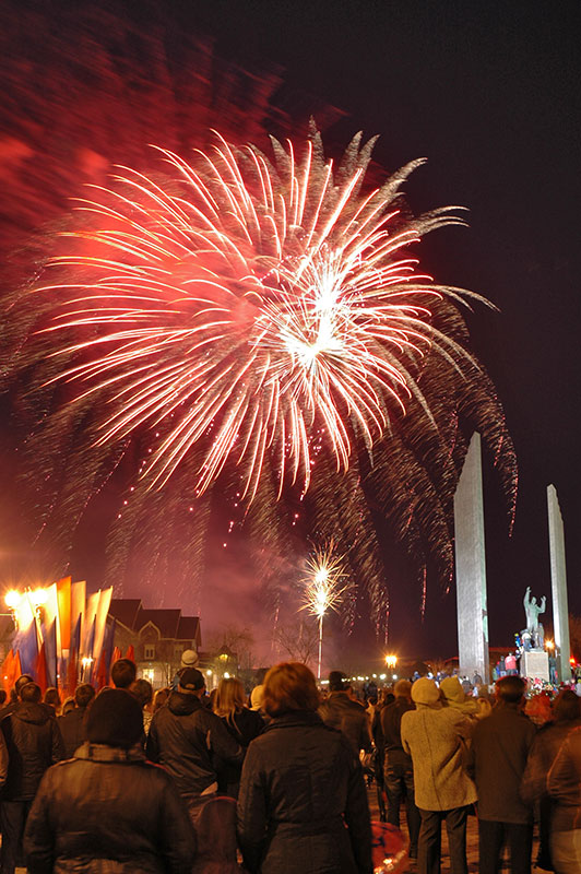
Fireworks, Gagarin Park, Orenburg, Orenburg Region, Russia
The highlight of my stay in Orenburg is my host Ruslan, a local with whom I immediately strike a lasting friendship. We sit smoking and drinking tea in his kitchen, then go to explore the city, walking down Orenburg’s elegant, tree-lined main boulevard to the Ural River, which is marked on either side by ceremonial posts labelled ‘Europe’ and ‘Asia’. The river is in flood, its surface a huge, glacier-like mass of broken ice and fallen trees, something Ruslan says he has never seen before. Sadly, the famous Orenburg Fortress, from which many of Russia’s expeditions into Central Asia were mounted is long-gone, though there are many charmingly shabby backstreets still to explore. After having another smoke in the ruins of a Tsarist-era electrical supply building, we are driven to Gagarin Park where we happen upon a huge fireworks display to mark the fiftieth anniversary of the first man being launched into space, one of the greatest achievements of the Soviet Union. Although Gagarin hailed from Smolensk region, it was here that he spent much of his time training as an air force pilot. The colours are especially vivid, and I feel it’s a fitting celebratory end to my year spent in and out of Russia.
After two very enjoyable, mellow days with Ruslan I have to say farewell to both him, and to Russia. My year-long visa, obtained in Tehran last year has come to an end, and I must finish this ninth trip into Russia which I have made with it. I drive south, past the town of Sol-Iletsk, home to Russia’s infamous Black Dolphin Prison, then turn south east to the border at Sagarchin. Despite a year of travel, I’m sad to be leaving Russia – the north and far east of this country are still unknown to me – but for now I am heading south, into the vast steppe of Kazakhstan, and a summer in Central Asia.
