
Stage 37 – Georgia: Valleys of the Greater Caucasus
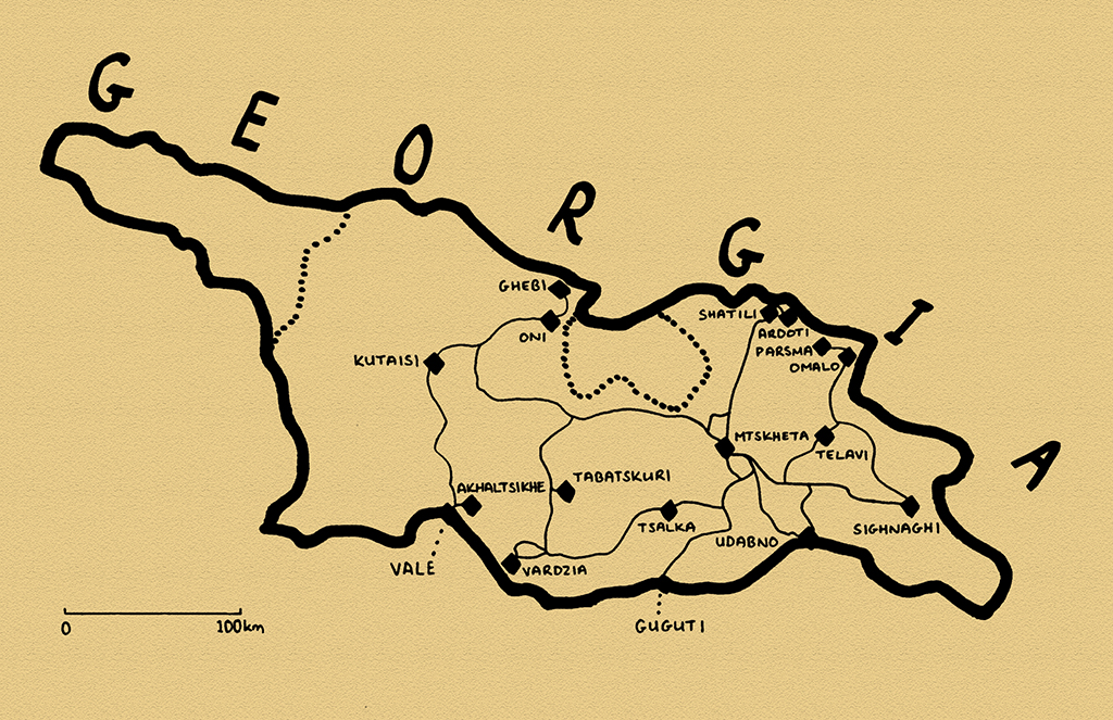
The modern state of Georgia occupies an area of mostly lush mountain valleys in the southern slopes of the Caucasus, bounded by the Black Sea in the west and the plains of what is now Azerbaijan to the east. A unified kingdom from the ninth to thirteenth centuries, from the Mongol invasion in 1243 until Russian annexation in 1801 Georgia existed often only as fragmented kingdoms and principalities, surrounded by much larger empires. Despite this however, the Georgian people have prevailed with a strong cultural identity, resisting incorporation into the neighbouring Muslim empires of the Turks and Persians and enduring almost two hundred years of Russian colonisation.
In 2010 I made my first visit to Georgia, driving from Azerbaijan into the breakaway republic of Abkhazia and on into Russia. I found a welcoming country of good-spirited people and unparalleled natural beauty, and left wishing to see more. On this second visit of more than three weeks I would loop around the country, visiting many of Georgia’s internal regions, often made up from the once distinct ancient kingdoms and principalities. Here I would find the enduring essence of the country, in picturesque villages with graceful stone churches, and mountains dotted by ancient stone towers and fortresses: the valleys of the Greater Caucasus.
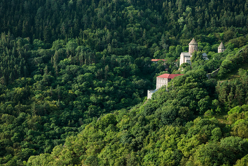
Sapara Monastery, Samtskhe-Javakheti Region, Georgia
On the 10th August 2014 I enter Georgia from Turkey close to the village of Vale, and drive the short distance to the regional capital, Akhaltsikhe. The contrast in landscape with Turkey is stark; gone are the wide, open plains and denuded hillsides, replaced by thickly forested mountains, here in fact the northern slopes of the Lesser Caucasus. Turkey’s squalid highland towns and villages, still rather torpid following the ugly demographic upheavals of the twentieth century are gone, replaced by more benign and permanent-looking settlements where very little looks to have changed in recent history. I attend to a few matters in town, then drive up above Akhaltsikhe into dense pine forest towards Sapara Monastery, which lies beautifully sited on a cliff edge in a fold of the forested mountains, with the conical dome of the fourteenth century Saint Saba Church poking above the treetops; a beautifully Georgian landscape. As it’s early evening I decide to stop for the night nearby and find a tiny clearing in the dense forest where I sleep in the cab of the truck as a thunderstorm breaks in the mountains above.

Landscape. near Zekari Pass, Imertei Region, Georgia
In the morning I return to Akhaltsikhe, a small but pleasant town set under a large and recently restored thirteenth century castle. It’s here that I meet an old friend of mine, Marcus, a German whom I first met in Romania during the very first days of the Odyssey more than seven years ago, and with whom I stayed for a few days in Siliguri, India, in 2008. Marcus arrives in a hired Nissan 4×4 with his eleven year old daughter Tamuna, and eight year old son Samiran. We leave Akhaltsikhe just after midday, driving initially towards Batumi on the Black Sea, but soon turning north onto what is listed on my map as a secondary road. We stop in the resort town of Abastumani and have a very pleasant and welcome soak in a hot spring, then buy some supplies for the evening and head for the mountains. Soon after leaving Abastumani the road deteriorates into a rough and rocky track passable only with a high-clearance vehicle, but it’s a fun drive through thick forest and, nearing the top of the pass where the trees disappear, we’re rewarded with stunning views over the forested ridges of Borjomi-Kharagauli National Park, which fall away to the south.
Skyline, Kutaisi, Imereti Region, Georgia
As we continue our climb, thick fog closes in on us, the temperature drops and darkness comes quickly. We park on the only available piece of flat ground, on the edge of the road just below the pass, and begin to strike camp and start cooking dinner. My concerns that the children will feel uncomfortable in such an environment are however unfounded; they are neither fearful nor protesting, and do not seem to mind that it is cold and dark, or that we will sleep on the side of the road. To my delight, they seem to appreciate the adventure for the new experience that it is.
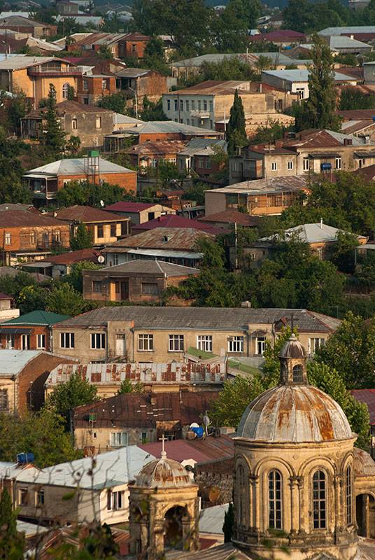
In the morning we walk briefly onto the surrounding hills from where there are stunning views of emerald-green grassy hillsides, topped by a muddy summer village consisting of a few ageing farm buildings. We cross the 2180 metre Zekari Pass, starting our descent towards the Greater Cacuasus, and there is noticeable change in vegetation with the damp northern slopes filled with shrubs and wild-flowers. The road becomes extremely rough as we descend back into forests, making slow progress until returning to asphalt in the town of Sairme which, filled with upmarket resorts and expensive black SUVs and luxury cars, feels rather ostentatious after the wholesome beauty of the mountains. We follow a river dropping gently through thick forest, emerging in the lowland town of Baghdati, birthplace of troubled Russia poet Mayakovsky, from where we drive to the capital of Imereti Region, Kutaisi, ancient capital of the Kingdom of Colchis.
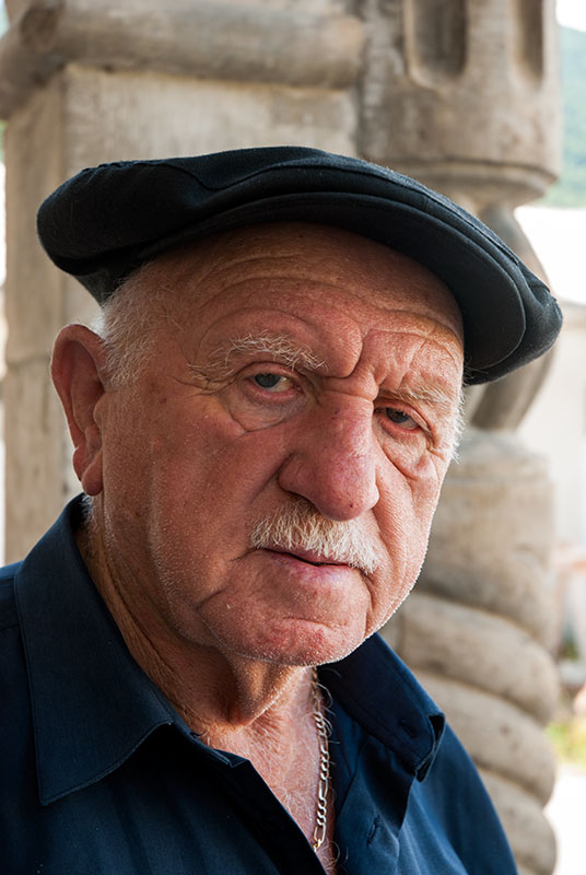
Jewish Man, Oni, Racha-Lechkhumi and Kvemo Svaneti Region, Georgia
We stop for a late lunch in Kutaisi, enjoying good Georgian food in a family-run restaurant set on a wide road of thunderous lorry traffic. Despite its size, Kutaisi feels to be composed mostly of rambling, leafy back-streets of small houses with only a single, though rather elegant, central square. On the north side of the Rioni River we stop to visit the eleventh century Bagrati Cathedral, a masterpiece of medieval Georgian architecture with soaring white limestone walls of tall, narrow arcatures so emblematic of Georgian Church architecture. Built in the early eleventh century during the reign of King Bagrat III, the first monarch of a united Georgia, the cathedral was heavily damaged during an Ottoman invasion in the late seventeenth century, and a long and latterly controversial restoration was only completed two years ago.
We drive east out of Kutaisi in the evening and stop for the night on a patch of empty ground not far away. Judging by the number of old shoes poking out of the ground, the site seems to be a landscaped rubbish dump, though Marcus and I tell the children that it’s a mass-grave; not that this seems to faze them very much, with Samiran happily sleeping in a tent well away from the cars.
In the morning we stop at another significant building; the early twelfth century Gelati Monastery, founded by King David IV (‘The Builder’), probably the most celebrated of Georgian monarchs. Not long after the death of Bagrat III, Georgia fell to the Seljuk Turks and it was David IV who regained Georgian independence in the end of the eleventh century, promoted Christianity and ushered in a Georgian Golden Age. Gelati Monastery belongs to this Golden Age, and one can see an advancement in style from nearby Bagrati, with greater use of carved stone ornamentation, and a proportionately larger, conical dome.
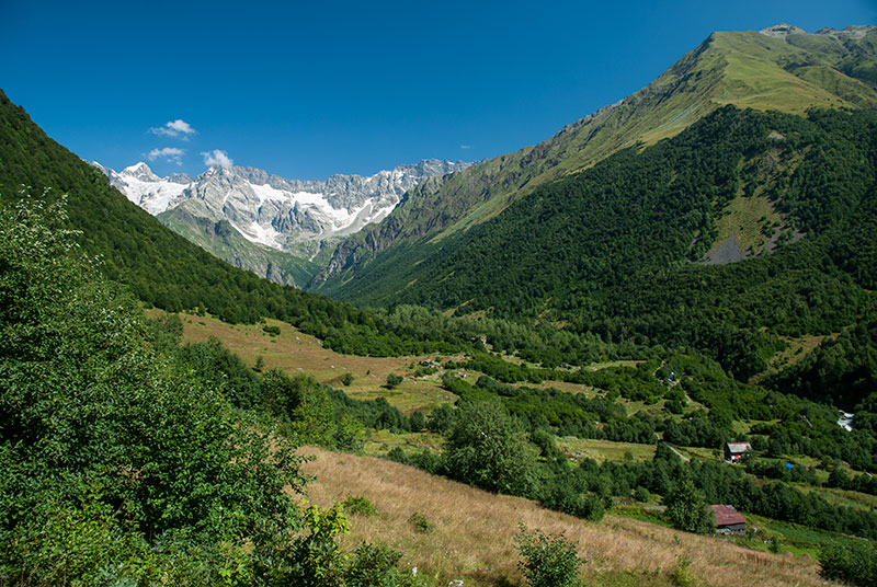
Chveshura Valley, Racha-Lechkhumi and Kvemo Svaneti Region, Georgia
Leaving Gelati we head north-east, through Tkibuli and up the Nakerala Pass from where we catch our first glimpse of the snowcapped Greater Caucasus, whose spine marks the border with Russia. We pass through Ambrolauri, the tiny capital of Racha-Lechkhumi and Kvemo Svaneti Region, then continue to climb to the even smaller town of Oni where we visit the very elegant late nineteenth century synagogue and meet a member of the tiny community of Georgian Jews, who claim direct descent from the Babylonian Migrants. Beyond Oni the road becomes very quiet as we enter real mountain scenery, then bifurcates, with the right hand track leading to the border of the breakaway Republic of South Ossetia. We take the left fork however, entering a stunningly beautiful valley surrounded to the south and north by snowcapped peaks. In the large, picturesque village of Ghebi we turn north (after stocking up on beer) onto a narrow, rough track entering the yet more beautiful Chveshura Valley and stop to camp next to a small, tree-covered stream where I have a welcome bath. I am rather amused upon finding out that Samiran has fouled his trousers but am soon the subject of laughter myself when, sitting down too quickly with a bowl of boiling noodles, I spill some on a very sensitive part of my crotch and literally scream in pain.
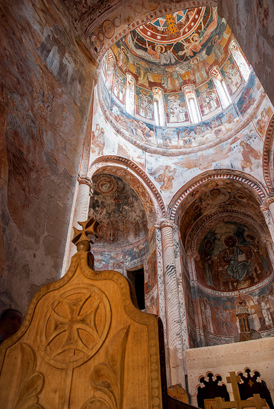
Frescoes, Saint Nicholas Church, Nikortsminda, Racha-Lechkhumi and Kvemo Svaneti Region, Georgia
We leave the cars the following morning and walk up further into the valley, passing a few summer houses sitting in glorious isolation of the modern world, several of which seem to be uninhabited. After a couple of hours walk, we pass a border patrol post beyond which the track becomes a narrow footpath and we enter thick, mixed forest of birch, beech and pine, then drop down to the cold, milky grey-blue waters of the Chveshura River, looking north towards a dramatic wall of the Greater Caucasus; an ancient, pale grey granite massif with thick glaciers in each defile and sharply defined crags and towers; some of the most impressive mountain scenery I have seen in all of the Caucasus.
Returning to the cars, we decide to stay in the same spot for another night, moving on the following morning. We back-track through Oni, and beyond Ambrolauri stop at the small village of Nikortsminda, home to the early eleventh century Saint Nicholas Church, which must be one of the most beautiful buildings in the country. Externally the church is small and well proportioned, stylistically of the Georgian Golden Age but covered in an unusual richness of decorative stone carvings; on the columns of the arcatures; a carving of Christ above two rosettes on the gable of the narthex wall, but most strikingly around each of the slot windows in the twelve sided drum supporting the church’s conical roof. Inside, the six apses of the hexagonal-planned church and the interior of the drum and dome are richly covered in sixteenth and seventeenth century frescoes depicting the life of Christ, unusually bold and well-preserved.
In the coal mining town of Tkibuli, which has an elegant main street of Stalin-era city blocks with arcaded ground-floor shop-fronts, we turn south towards Zestafoni where we join the horrendous traffic of the country’s main highway, which we take eastwards towards our overnight stop in Mtskheta. The heavy traffic and wild local driving style are a change of pace from the idyllic mountains we have spent the last few days in, only easing as the road turns into a much needed divided highway near Gori, after which we pass the southern edge of South Ossetia, from where the Russian Army made a brief incursion into Georgia in 2008.
We stay at a home-stay in Mtskheta run by Gerhard, a retired German civil servant and his Russian wife Julia whose good company, home-cooked food and wonderful, shady garden on a hillside just north of the Mtkvari River make for a relaxing rest stop and a rare chance to spend a day doing almost nothing. We’re also joined here by Lia, half Slovenian, half Japanese, whom I first met in Russia four years ago.

Jvari Monastery, Mtskheta-Mtianeti Region, Georgia
Mtskheta is Georgia’s spiritual capital, and its most important monument is the beautifully located Jvari Monastery, built atop a steep ridge overlooking the confluence of the Mtkvari and Argavi Rivers. Jvari harks back to Georgia’s oldest history, when its territory was divided into the two kingdoms of Colchis in the west and Iberia (Kartli in Georgian) here in the east. Mtskheta was the capital of Iberia and according to legend the site of the conversion of pagan King Mirian III of Iberia by the female evangelist Saint Nino of Cappadocia, thus converting the kingdom to Christianity in circa 327. Nino is said to have planted a miracle-working cross on the site of a former pagan temple, and it is on this spot that the current church was built in 590 to 605. Jvari is an elegantly simple tetraconch church, an evolution of an earlier Byzantine design whose origin of design is a matter of dispute between Georgia and nearby Armenia. Lia and I visit on a Sunday morning when the church is busy with domestic and foreign visitors, thronging around the large cross which dominates the church’s interior, spot-lit by shafts of brilliant sunlight from small slot-windows which pierce through the smoke-filled air of the church; the very origin of Georgian Christianity.

Sighnhagi, Kakheti Region, Georgia
Late in the morning the five of us set off, bypassing the northern edge of Tbilisi on the ring road and turning east into Kakheti, Georgia’s easternmost region, famed for its wine. We drive through a gently rolling agrarian landscape that looks much more like the Mediterranean than the valleys we have been in for the last week, climbing finally to the attractive town of Sighnaghi. Built on top of a hill in the eighteenth century, several hundred meters over the neat patchwork fields of the Alazani Valley, Sighnaghi is an extremely attractive walled city with cobblestone streets, galleried stone houses with terracotta-tiled roofs, small squares with street cafes and the modestly beautiful cobble-stone Saint George’s Church all giving one the feeling of being in Tuscany or Catalonia. We spend a warm, peaceful night camping on a nearby hilltop, then drive towards the Alazani River in the morning, stopping on the northern side of the river at Gremi, once the capital of the Kingdom of Kakheti and a flourishing Silk Road city, destroyed by the Persians in the early seventeenth century, leaving only the remains of a stone fortress and the slender sixteenth century All Saints Church with an almost needle-like dome.

Keselo Fortress, Upper Omalo, Kakheti Region, Georgia
We stop for lunch in the small town of Kvemo Alvani, then head north into the mountains, aiming for the historical region of Tusheti, across on the northern slopes of the Greater Caucasus in the far north-east of Georgia. What starts as a reasonable dirt track along the Stori River soon enters a narrow, rocky gorge filled with small waterfalls and beautiful beech forest where the track, in places hewn from the rock, becomes extremely rough and slow-going. After some time the road emerges from the forest, improves slightly and climbs along the steep, lime-green grassy hillsides, high above deep river valleys, cresting successively higher ridges in sets of tight switchbacks until, late in the afternoon, we cross the 2860 metre Abano Pass and enter Tusheti. We drop more than one thousand metres from the pass, back into a narrow forested gorge where we camp for the night.
In the morning we drive up to Omalo, close to the junction point of Tusheti’s two main valleys: the Tushetis Alazani and, further north, the Pirikitis Alazani, running under the peaks to the north which mark the Russian border. Omalo is Tusheti’s largest settlement and is overlooked by the recently restored Keselo Fortress, a series of blocky medieval towers built on a rocky outcrop, overlooking several nearby valleys. Tusheti has been settled since at least the third century BCE and was something of an outpost of paganism; though nominally Christianised in the ninth century, strong pagan influences persist in Tushetian culture. Today Tusheti is rather depopulated, with many Tushs having moved down to what historically were summer grazing grounds around Kvemo Alvani, visiting the highlands only for festivals or to serve the recently arrived tourism industry. This is not so hard to understand, given that the only access to the valley is via a rough track requiring a four-wheel drive vehicle, which was only completed in the early 1980s, and that the valley still lacks even an electricity supply.

Tushetis Alazani Valley, near Verkhovani, Kakheti Region, Georgia
We spend two days in Tusheti; first driving along the Tushetis Alazani Valley and stopping near the village of Alisgori where we camp next to the river and walk up into the hills the following morning, visiting a ruined watchtower and a traditional Tushetian khati, a small stone shrine made from flat blocks of shale and slate, topped by a cross; a pagan shrine which women are still forbidden to approach. The next day we back-track towards Omalo and drive along the wider Pirikitis Alazani Valley, through the large village of Dartlo with its defensive towers and wooden balconied stone guest-houses, surrounded by ruins and deforested hillsides, clearly once a far larger settlement. Further west, the valley passes the almost abandoned village of Chesho, also overlooked by a stone watchtower, then narrows and becomes even more beautiful as we near the village of Parsma and park the cars for the night next to the river, where we camp. In the morning I walk up into the village, consisting of perhaps thirty houses of stone stained orange by lichen, with rusty steel roofs and a few towers, of which all but one are ruined. Up above the village is a cemetery where graves are marked by unhewn river stones and a khati where thin, honey-coloured church candles have recently been lit. I speak to a local who tells me that in summer the population is around fifty as the Tush bring their flocks up to graze, but that the village is deserted in winter. Though this has been the way of life for many Tush for the last few centuries, it is clearly now in decline, though for once tourism may present a means for it to be sustained.

David Gareja Monastery, Kakheti Region, Georgia
We drive back down out of the mountains, retracing our route to Kvemo Alvani and on to reach the charming capital of Kakheti, Telavi, in the evening, then continuing slowly the following day southwards, crossing another forested ridge and dropping down to the torrid lowlands of Georgia’s far south-east. Here the country’s seemingly unending greenery finally abates, leaving a dry and dusty landscape which looks more like Central Asia than anywhere else in Georgia, with beautiful rolling plains of yellowed grass, flocks of sheep and goats and occasional, rather forlorn-looking villages. Beyond the shabby town of Udabno we camp on a smooth grassy ridge, enjoying the warm, dry night air and clear skies after several cool, damp nights in the mountains.
Just south of our campsite, hard up against the Azerbaijani border is the exotic looking monastery complex of David Gareja, highly fortified with a thick stone wall closing it off against a steep ridge, giving it a real sanctuary atmosphere. David of Gareja was one of the legendary ‘Thirteen Assyrian Fathers’, missionaries from Mesopotamia which the Georgian Orthodox Church celebrates for setting up thirteen monasteries and strengthening Christianity in early medieval Georgia. The monastery is said to have been founded by David in the sixth century, and has endured attacks by the Seljuk Turks, Mongols, Tamerlane and the Persians, then neglect and partial destruction by the Soviets, only returning to active use in 1988. We walk up a steep, dusty path to the top of the ridge, which marks the Azerbaijani border. Walking ahead of the others, I drop down from the ridge into what is Azerbaijani territory (a subject of dispute between the two countries) and walk along a string of collapsed cave churches, their half-vanished ceilings now open to the elements but still bearing remains of frescoes dating from the tenth to thirteenth centuries.
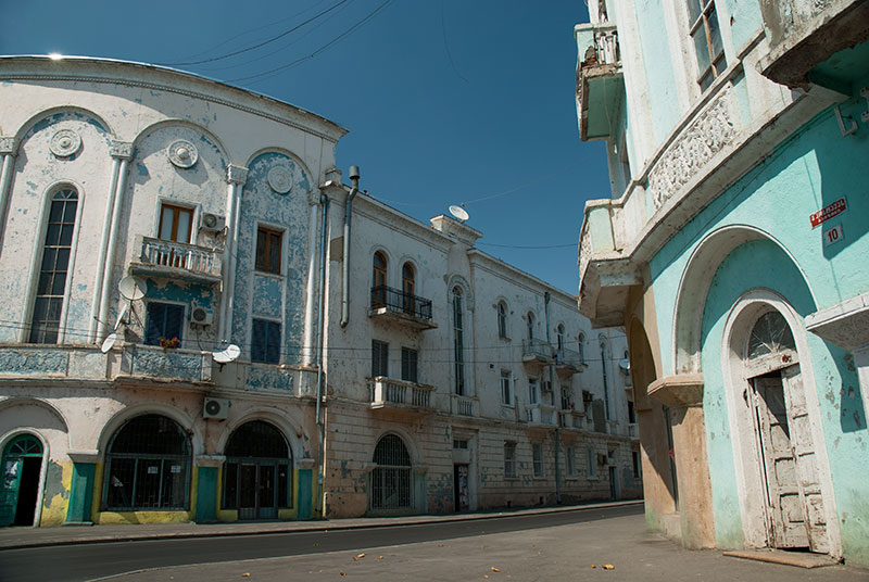
Rustavi, Kvemo Kartli Region, Georgia
We leave the monastery heading westwards on a rough track, eventually catching the edge of the irrigated farmland around the Mtkvari, driving along a distributor canal into the town of Gardabani which has a majority Azerbaijani population, but which with Georgian, Russian, Ukrainian and Armenian minorities has a curiously Soviet-cosmopolitan atmosphere. We have lunch in a nice open air restaurant, then continue north through the regional capital of Rustavi, a heavily industrialised city which looks to have changed very little since Soviet times; down at heel but with a charming centre of Art Deco influenced early twentieth century Soviet urban architecture. By-passing Tbilisi, we return to Mtskheta from where Marcus and the children spend a final day before flying back to Germany. I’ve really enjoyed their company over the last two weeks, but more than that, Marcus has shown me that children need not put an end to a traveller’s lifestyle and that, having brought his children up in multiple countries and without the awful influence of television, they look at the world without fear, and at strangers without any pre-judgement whatsoever; ideal qualities for a traveller.

Lebaiskari Tower, Mtskheta-Mtianeti Region, Georgia
Lia and I leave Mtskheta and head for the mountains again; this time due north along the first few kilometres of the Georgian Military Highway, which connects the capital to the only functioning border crossing with Russia, then turning off to pass the turquoise water of the Zhinvali Reservoir, onto a dirt track running along the Pshavi Arguni River, entering the historic region of Khevsureti. We cross the 2680 metre Datvisjvari Pass on a good dirt road, overlooking a wide, green, deforested valley punctuated only by the lone Lebaiskari Tower, which like the towers of Tusheti is built in the Vainakhish style, as seen in the Russian republics of Chechnya and Ingushetia directly to the north, and different from the more European-looking stone towers of Svaneti to the west. Khevsureti, like Tusheti, is an isolated mountain refuge of medieval traditions and architecture, and the Khevsur people have very strong pagan and animistic traditions below a veneer of Christianity. Famed as warriors, the Khevsur have traditionally fought with their Muslim neighbours to the north, and there is (perhaps mostly romantic) speculation that they are descended in part from a lost group of medieval crusaders, though this is no doubt influenced by the fact that the Khevsurs wore chain mail well into the twentieth century.
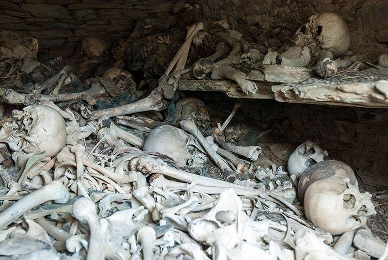
Mausoleum, Mutso, Mtskheta-Mtianeti Region, Georgia
The track descends gently, passing the striking medieval complex of Shatili, composed of perhaps fifty towers and stone houses with wickerwork balconies dating from the twelfth century and recently restored. Just beyond Shatili, the track comes to within a few hundred metres of the Chechen border, then doubles back up into the Andakistskali Valley, where we drive to the end of the road below the village of Ardoti and camp for the night. In Ardoti we see the ruined shell of a twelfth century stone church, still used it seems by villagers judging by the presence of candles and icons, then drive back past a number of Khevsur graves, one of which from 1930 depicts the deceased in full chain mail with sword and shield. A little further down the valley we stop below Mutso Fortress; a large rocky knoll covered in abandoned stone houses and towers, like a ruined Tower of Babel. We walk up a steep side valley, then cross a stream and walk towards Mutso, passing five open mausoleums full of skeletons, some still with scraps of clothing and traces of flesh. Unlike Shatili, Mutso itself is totally abandoned and in need of preservation. With most Khevsurs having moved to Tbilisi in the twentieth century, the isolated culture of this mountain community seems to be highly threatened.
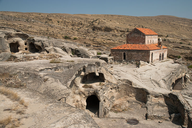
Uplistsikhe, Shida Kartli Region, Georgia
We spend the next two days driving up the broad Mtkvari Valley, alternating between the busy main highway and quiet backroads, stopping-off at various churches; the huge, restored Cathedral of Samtavisi with massive stone carvings on its eastern wall; Metekhi Church with an unusual tapering drum, then stopping at the cave city of Uplistsikhe. One of the oldest settlements in the Caucasus, the heavily damaged caves of Uplistsikhe show architectural influences from Anatolia and Persia, and were a cultural centre of pre-Christian ancient Iberia. We continue through the elegant city of Gori, which since my previous visit in 2010 has lost its large statue of Stalin, who was born here, then continue to more of the Mtkvari Valley’s churches; the beautiful tetraconch churches of Ateni Sioni and Samtsevrisi, both very similar to Jvari, and the large, sixth to seventh century three-aisled basilica of the walled Urbnisi Monastery, built on the site of an even earlier city.
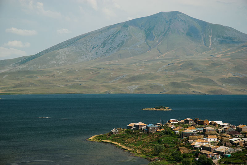
Lake Tabatskuri, Samtskhe-Javakheti Region, Georgia
We leave the main highway towards the coast at Khashuri, driving further up the Mtkvari Valley to the rather dull resort town of Borjomi, famed for its mineral water. Here we turn south and climb once more into the mountains, through dense pine forest to the resort of Bakuriani, filled with the Georgian nouveau riche in badly driven, black SUVs, and with children in expensive clothes; a place I take a strong and immediate disliking to. Leaving the crassness behind, an unpaved road climbs further into the beautiful forested ridges of the Lesser Caucasus, climbing up above the tree-line and into the clouds to the 2430 metre Tskhratskharo Pass where we turn east towards Lake Tabatskuri. Here the scenery becomes immediately very different; a high, rolling volcanic plateau which is physically part of the Armenian Highlands rather than the typical valleys of Georgia. We drive through a flat grassland on which farmers have made summer camps and are cutting the grass, piling it into neat ricks. Cresting a small ridge, we catch out first glimpse of the lake, with the almost Scandinavian-looking village of Tabatskuri located on a small peninsula jutting into the lake. We find a magnificent campsite on the northern edge of the lake, overlooking its steely-blue waters against a backdrop of volcanic peaks.
The next day we drive around the western edge of the lake on rough tracks, passing small, isolated and poor-looking villages up on the plateau. This highland corner of Georgia, known as Samtskhe or Meskheti, in addition to the region of Javakheti further to the south, was transferred from the Ottoman to Russian Empires in the nineteenth century, and was heavily populated by Armenians fleeing oppression under the Ottomans. When Stalin exiled the Meskhetian Turks from the area en masse in November 1944, Armenians settled the newly vacated areas. Today the region remains majority Armenian and, as we drive through rather far-flung villages such as Kochio and Baraleti, we see Armenian script used in local shops, and the characteristic pink tuff and black basalt churches; simple boxes with a pitched roof and small bell tower, usually in a state of disrepair. We rejoin the main road near the city of Akhalkalaki, then drive back to the Mtkvari Valley, following it upstream to the cave city of Vardzia.

Forest, near Apnia. Samtskhe-Javakheti Region, Georgia
Like Uplistsikhe, Vardzia has been inhabited since the Bronze Age, but it is famous for its connection with Queen Tamara, who reigned in Georgia from 1184 to 1213, during the height of the Georgian Golden Age which saw Tamara consolidate her Caucasian empire; it was said to be from here in Vardzia that she set off west in her campaign against the Muslims in the very early thirteenth century. Today Vardzia, once inaccessible due to its proximity to the sensitive Soviet – Turkish border, is popular with Georgian and foreign tourists, who come to see the beautiful late twelfth century mural of Queen Tamara in the rock-carved Dormition Cathedral. After visiting the caves, Lia and I go for a dip in some hot-springs just south of Vardzia, then drive up a steep and rough set of switchbacks on the cliff-face opposite the cave city, leading to the village of Apnia, set in a beautiful landscape of rolling green parkland, where we camp next to open, planted pine forest with magnificent views of the mountains of Turkey to the south-west.
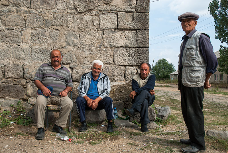
Greek Men, Beshtasheni, Kvemo Kartli Reigon, Georgia
Leaving this wonderful campsite the next morning, we drive back towards the capital through the highlands of Javakheti; first through more impoverished-looking villages, past the abandoned railway station outside Akhalkalaki, then turning east in Ninotsminda onto a new road. At the slate-grey highland Lake Parvani we turn off the road temporarily, passing through highly isolated communities of Doukhobors; radically pacifist Russian dissenters exiled here by Tsar Nicholas I in 1830, who here live in distinctive sod-roofed wooden houses. Rejoining the main road it’s a very brief climb to the 2170 metre Tikmatashi Pass, from where the land steadily drops. We stop for lunch in the majority Greek town of Tsalka, then leave the main road again to visit the village of Beshtasheni which has a black basalt Greek Orthodox church, whitewashed around its sky-blue doors, above which is a stone with a Greek inscription. Just near the church I meet two Pontic Greeks, whose lives are a story of exile and flight; from a background of Turkish-speaking Pontic Greeks who fled Ottoman Turkey, born here in Soviet Georgia and now living in Thessaloniki in Greece, thus speaking Turkish, Georgian, Russian and Greek; four totally unrelated languages.

Mtkvari Valley, Mtskheta-Mtianeti Region, Georgia
As we drive further eastwards, we drop back into the typical Georgian landscape of wooded river valleys, past the rather drab town of Manglisi. It’s after midnight when I drop Lia off at Tbilisi Airport and continue alone to Mtskheta in the small hours, passing Gerhard and Julia’s place and driving to the monastery named after another of the thirteen Assyrian Fathers: Shio-Mgvime. After a brief sleep I visit the monastery before any other visitors arrive, then climb up a beautiful ridge of dwarf oak forest to a small chapel overlooking the broad Mtkvari Valley. Here I have a serene moment looking over the very heartland of Georgia, where the hills fall away into the late summer haze; green and thickly wooded on their higher slopes, parched and dry where they flatten to reach the river, with small areas of greenery marking the patchwork of villages which spread from here to the Black Sea. This, I think to myself, is the real Georgia.
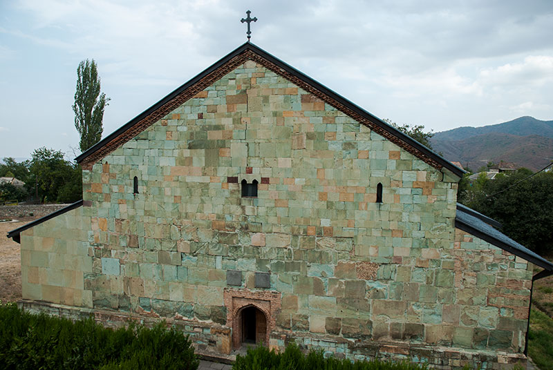
Bolnisi Sioni Church, Bolnisi, Kvemo Kartli Region, Georgia
I spend three days relaxing in Mtskheta with Gerhard and Julia, enjoying the late summer days in their shady garden. The sting is now starting to go out of the sun, the leaves beginning to turn and my thoughts are focused towards finally entering Armenia; the only country in the Former Soviet Union which I have not yet visited. On my last drive out of Mtskheta I choose to drive through Tbilisi, a city I have very fond memories of from my visit in 2010, then drive south through Marneuli to Bolnisi. Bolnisi was founded by German settlers in the early nineteenth century and retains a few scruffy pitch-roofed German houses, but is otherwise like any other of the nearby towns; rather shabby, impoverished-looking and inhabited mostly by Azerbaijanis whose style-less new mosques look rather out of place in the Georgian countryside. Just outside of Bolnisi however, I visit one final church; that of Bolnisi Sioni; a three-aisled basilica constructed between 478 and 493, built from beautiful blocks of green and pink tuff, the oldest extant church in Georgia. In addition to Christian symbology, the church has pagan-influenced carvings of animals and plants, as well as the oldest example of the Georgian alphabet found in Georgia; here the in the early Asomtavruli script, in which one can see clearly the similarity with the Armenian alphabet.
From Bolnisi the road turns south, passing the archaeological site of Dmanisi, home to a 1.81 million year-old Homo fossil, the oldest found outside Africa. I then climb on an empty road into beautiful beech forest and further, upwards to the edge of a plateau and the border with Armenia where I leave Georgia from the bleak village of Guguti.
On this second trip to Georgia I have gone beyond the country’s most obvious attractions, finding it to be surprisingly polyglot and decentralised for such a small country. The Georgians, with whom I have sadly had rather little contact on this trip, seem to be sitting back in their slice of paradise, enjoying new-found independence and waiting to see what the future brings, though as a pawn between Russia, the EU and the US, this is not at all certain. My strongest impression is unchanged however; that Georgia is overwhelmingly, unendingly beautiful, no matter which part one visits.
