
Stage 36 – Iran, Azerbaijan & Turkey: The Armenian Highlands

Modern Armenia is a small, mountainous country, lacking in natural resources and highly isolated both physically and politically. In the past however, successive Armenian kingdoms spread across a far greater area surrounding legendary Mount Ararat, including much of what is now called Eastern Anatolia, the far north-west of Iran, and parts of Azerbaijan and Georgia: an area known as the Armenian Highlands.
I would start my journey visiting Armenian sites along the north-western borders of Iran, a country which still has a thriving Armenian minority, before crossing the Aras River into the intriguing Azerbaijani exclave of Nakhchivan. From here I would re-cross the Aras, this time into Turkey, where I would loop around the troubled, Kurdish south-east of the country, revisiting a few sights I had passed during my first overland trip to Asia as a backpacker in 2003. Despite the fond memories however, my overwhelming impression would be one of melancholy and tragedy from the glaring cultural decline; the impoverished Kurds, themselves victims of repression by the Turkish state, living amongst the ruins of their vanished Armenian forebears whose crumbling churches lie in neglected, silent testament to the forced movement of Christians out of Anatolia. Ninety nine years after the Armenian (and Assyrian) Genocide, the brutal demographic upheavals of the twentieth century still appear very obvious on the cultural landscape of the Armenian Highlands.
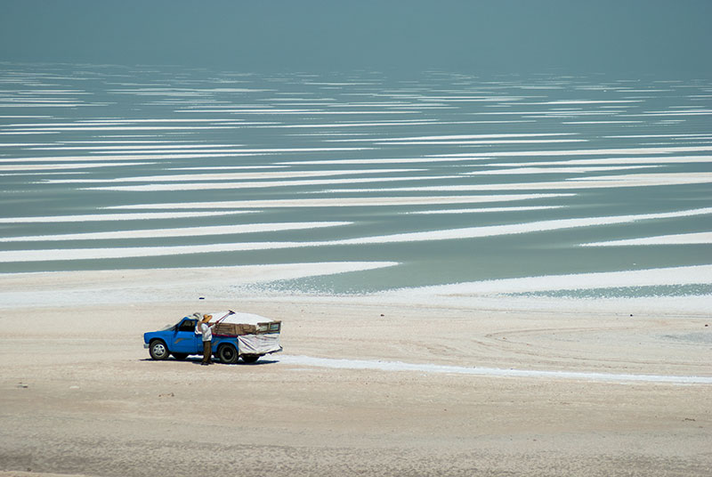
Salt Flats, Lake Urmia, West Azerbaijan Province, Iran
I leave Tabriz on the morning of the 26th July 2014, heading south-east towards Lake Urmia. In 2003, on my very first visit to Iran, I had crossed the gap in the then unfinished causeway across the lake in an ancient Chevrolet savari (share taxi), using a pontoon ferry. Today, the bridge is complete and the ferry lies scuppered and rusting in a briny pool, but ironically, and rather tragically, the water of the lake has almost disappeared. Due to intensive use of water for agriculture, Lake Urmia is just ten percent of its original size, and what was a large lake eleven years earlier is now a large area of parched, salt-flats which look very much like the bed of the former Aral Sea in Uzbekistan. In what used to be the centre of the lake, a few stretches of lifeless, hyper-saline water remain in a landscape of furrowed white salt mounds which stretch to the point where the lake surface seamlessly merges with the sky, looking almost like melting pack-ice. I stop on the causeway to look out over this bleak landscape, watching a man shovelling and raking salt into the back of a blue pickup truck. It’s quite disturbing to see personally such disastrous environmental change occur over so short a period of time.
I turn north on the far side of the lake, soon passing a weathered, third century Sassanian bas-relief near the village of Khan Takhti which shows a victorious King Ardeshir and Prince Shapur returning from the successful conquest of Roman Armenia. The fact that one may find such ancient artwork almost unmarked, and unprotected at the side of what must be a very ancient road, is another great joy of Iran. Continuing north, beyond Khoy I turn off the main road to the village of Bastam where I see my first Urartian site; the stone-walled remains of a small settlement, perched on a naturally defensible cliff overlooking the entrance to a green, watered valley. The Urartians were an Iron Age civilisation, contemporaries of the Hittites, centred on the Lake Van region, who flourished from the ninth to sixth centuries BCE and are thought to be the ancestors of the Armenians. As I loop across the Armenian Highlands, I will encounter several more of their intriguing ruins.
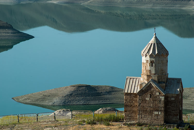
Dzordzor Chapel, West Azerbaijan Province, Iran
From Bastam I drive north-west on a small road, climbing onto a beautiful upland of Azerbaijani villages where women still wear colourful dresses. Here, tucked away in a small valley is the imposing Monastery of Saint Thaddeus, which legends tell was originally built in 68 AD by the Apostle Jude Thaddeus, who preached the Gospel in the area. However, much of what can be seen dates from the early nineteenth century and while it is impressive, particularly for its fine stone carvings, its black roof and heavy stone defensive walls against dark volcanic hills make it a rather dour and austere structure. More beautiful is the nearby chapel of Dzordzor, which I reach after driving through Chaldiran and into another hidden valley on a dirt track. The chapel is all that remains of a larger monastery whose ruins have been inundated by the nearby Zangmar Dam, with the chapel having been moved stone-by-stone by the Iranian authorities in the late 1980s; a touching example of the respect the revolutionary Iranian authorities have for the Christian Armenian minority in Iran, and in general for historical architecture. I camp next to the chapel in a compellingly beautiful location, passed in the evening by a local shepherd with his flock but otherwise totally alone. Dzordzor is a stunning piece of Armenian architecture, amongst the very finest I have seen; a slender, white limestone miniature cross-church with a soaring, pencil-like drum, topped by a delicate, faceted cone roof supported on zigzagging gables.
Saint Stepanos Monastery, East Azerbaijan Province, Iran
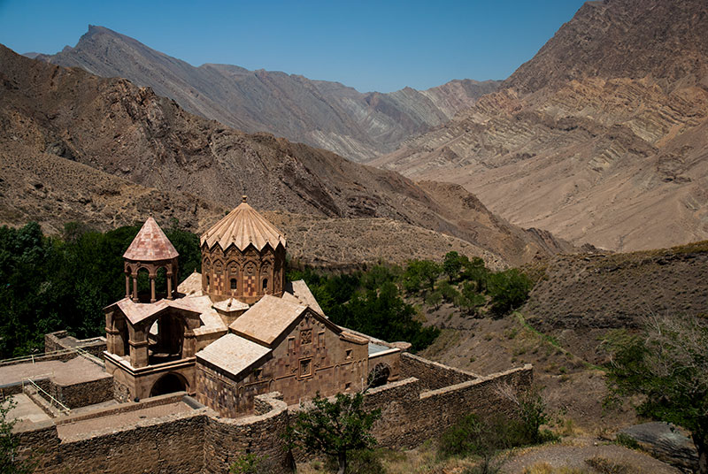
I leave Dzordzor on a beautiful morning, crossing a high pass to the north and descending to the town of Maku, very close to the Turkish frontier. Here I turn east, leaving the main highway and driving to the Aras River, which marks the boundary between Iran and the Azerbaijani exclave of Nakhchivan. I follow the river downstream, initially through flat plains, passing the Aras Reservoir, then entering a striking, steep, red-rock gorge, with the road narrow and perched immediately on the river’s right bank. It is in a steep side valley from this road that I find a third piece of preserved Armenian architecture; the elegant pink tuff Saint Stepanos Monastery, set in a walled compound with a lush garden fed by a cold spring, in stark contrast to the dry red mountains which soar all around it. Originally built in the ninth century, the current structure dates from Safavid times and is magnificent in its elegant proportions with a fine bell-tower, ornate carvings on the tambour (drum) and a bas-relief of the Stoning of Saint Stepanos on the gable of the narthex.
Back on the main road it’s a short distance to the border town of Jolfa, where a bridge connects Iran with Azerbaijan’s Nakhchivan Autonomous Republic. Jolfa has been heavily redeveloped as a part of the Aras Free Trade Zone, but the border, even by Iranian standards, is utterly chaotic and totally unaccustomed to foreigners crossing with a vehicle. Nobody speaks English or Russian and I am led around by a ‘fixer’ who seems not even to speak Persian; only through a German-speaking Turkish lorry driver am I able to understand what is going on. I have to visit various offices in order to stamp my carnet, pay a spurious diesel surcharge for fuel I am taking out of Iran and eventually barter with the fixer who demands an exorbitant sum for his services. My nerves are shot by the time I finally cross the bridge into Azerbaijan where, expecting worse, I find the exact opposite; procedures are conducted in a calm and professional manner and several of the customs officers speak Russian and one even English. They are curious to see a foreigner driving across the border, but swiftly process my documents so that by mid-afternoon I’m free to drive to the capital, Nakhchivan.
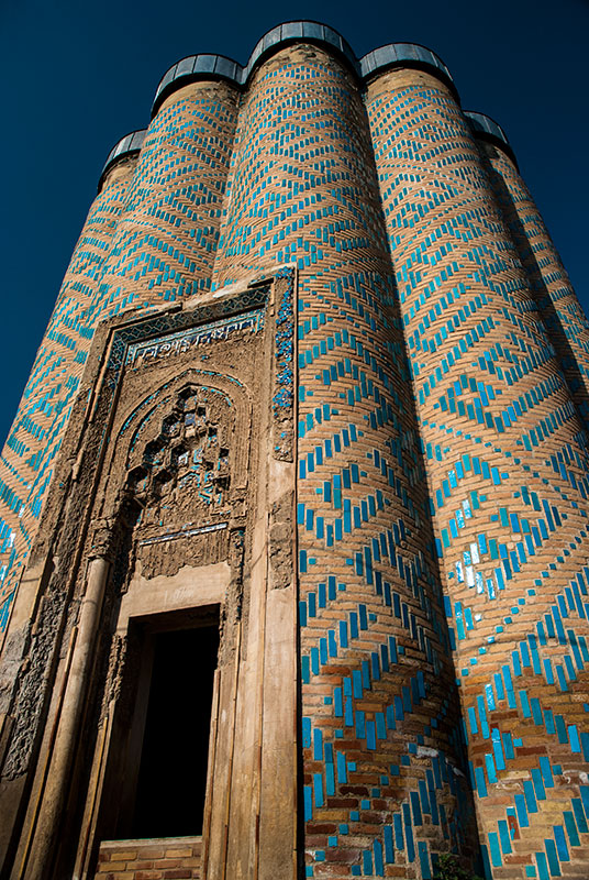
Mausoleum, Qarabağlar, Nakhchivan Autonomous Republic, Azerbaijan
This tiny exclave of Azerbaijan was once an independent khanate and today is a geographical oddity resulting from intense historical manoeuvring between Persia, Ottoman Turkey and Imperial Russia, leading the Soviets finally to cede it (and Nagorno Karabakh) to Azerbaijan. Undoubtedly once part of historical Armenia, the Azerbaijani authorities are guilty of the rather pathetic practice of destroying all Armenian churches and cemeteries in the territory in order to remove all traces of their historical inhabitants, in petty retaliation for the Armenian occupation of Armenian-majority Nagorno Karabakh, the conflict at the root of Armenia’s intense present-day political isolation.
I’m thrilled to have made it without any issue into this geopolitical oddity. However, having always been a sensitive border region of the USSR, and now an exclave separated from the ‘mainland’ by hostile Armenia, Nakhchivan has something of a reputation for official paranoia and mistrust of foreigners and as I carefully drive on the new highway to the capital, I notice that I am being followed. Reaching Nakhchivan I meet my local host Tale who speaks briefly with my tail and explains that I am his guest; the last time before the border that I have any interaction with the local authorities. I stay with Tale in a room rented out by his great aunt Sonja, a cheery seventy year-old widow who plies me with ice-cold watermelon and peaches; very welcome after the fierce afternoon heat. Tale and I head into town where, after a month in dry Iran, my most urgent wish is to drink a beer. We head down into an underground bar, where we drink the local Nakhchivan beer with small plates of chickpeas, served by an English-speaking Nigerian waiter who is a student in the local university, and tells me he is studying, of all things, French. What a perfect day.
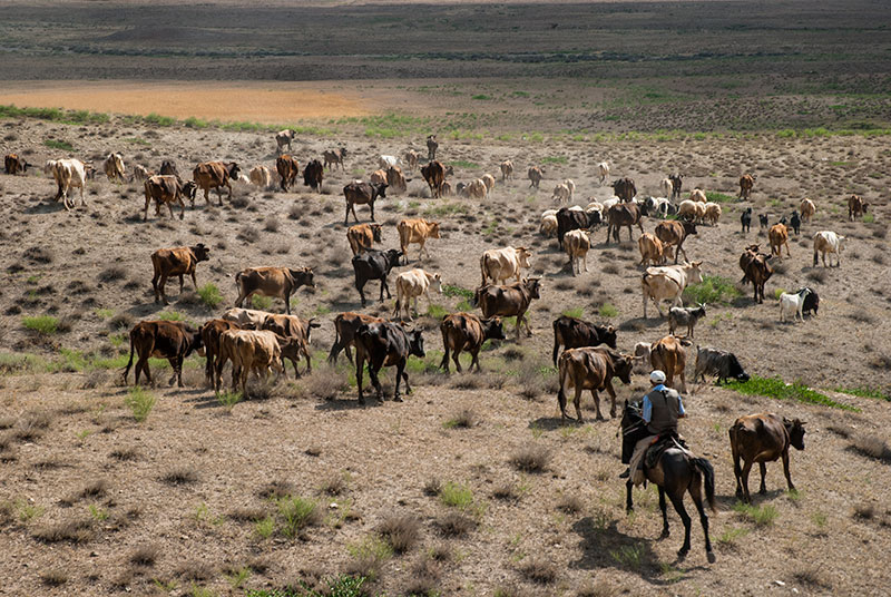
Cowboy, near Tazakand, Nakhchivan Autonomous Republic, Azerbaijan
On my first full day in Nakhchivan, Tale and I start by driving north on the main highway towards the Turkish border, turning right into the small village of Qarabağlar where I admire a stunning piece of Islamic architecture; an unnamed, round, tower-mausoleum consisting of twelve semi-circular facets, each with stylised Kufic verse in turquoise tiles. Unusually, the mausoleum has four portals, each with niches of fine stalactite moulding. It’s a highly distinctive piece of architecture, reminiscent only of a similar, taller but plainer minaret in Jarkurgan, in the far south of Uzbekistan. We return back to Nakhchivan by a circuitous route, leaving the road near Tazakand into a landscape of cowboys and dry red hills, cutting cross-country to the next green, oasis-like valley where stork’s nests sit on rooftops and telegraph poles, then return southwards to the capital.

Azerbaijani Shepherd, near Diza, Nakhchivan Autonomous Republic, Azerbaijan
In Nakhchivan we meet Tale’s friend Murad, who works for the country’s customs service and has an impressive knowledge of regional geopolitics, explaining the careful balance of power between Azerbaijan and Armenia as proxies respectively of Turkey and Russia; age old adversaries in the Caucasus. Nakhchivan is a small city, but one endowed with the ministries and other official buildings of a national capital, which seem quite out of place given the tiny size of the city. It is the hometown to former president of Azerbaijan Heydar Aliyev (father of the incumbent) and boasts a particularly large and centrally located Aliyev Museum. Nakhchivan is nevertheless a historical place, with its finest building, the thirteenth century Momine Khatun Mausoleum located in a central park, a ten-sided tomb-tower with finely restored geometric brickwork, a beautiful turquoise Kufic frieze and stalactite-moulding around a simple dome roof; more intricate but less architecturally exuberant than the mausoleum in Qarabağlar. Down in the backstreets in the south of town is the simpler, more common style of hexagonal-plan mausoleum of Yusuf ibn Kuseir, built by the same architect, and beyond in park still under construction a modern shrine dedicated to what is claimed to be the tomb of Noah, labelled ‘6th Millennium BC’, which is rather hard to take seriously.
On my second day in Nakhchivan Tale and I head south, leaving the main road running south back towards Julfa and heading towards the tooth-like volcanic plug known as Ilhan Dağ, which rises abruptly from the rolling plains along the Aras Valley. We drive on dirt tracks, passing sharply eroded badlands grazed by the flocks of friendly shepherds, then reconnect to the main highway and head for the far south-eastern tip of the Republic, past a seventeenth century bridge in Aza, then climbing inland to the town of Ordubad.

Shahsahar Mosque, Ordubad, Nakhchivan Autonomous Republic, Azerbaijan
Ordubad is exactly the kind of place I was hoping to find here: a picturesque, largely unmodernised Azerbaijani mountain town. Backed by views of mountains on almost all sides, Ordubad has steep, winding streets of mud-brick houses with old wooden gates and walled gardens of walnut and mulberry. In one street a local points us to an opening in the ground, through which a flight of steps leads down to an old, still functioning karez, an ancient hand-dug underground water conduit used to bring water down from mountain springs to arid areas. A number of mosques dot the town; none of them spectacular but nevertheless adding to the traditional atmosphere, particularly the Shahsahar Mosque which spans adjacent streets with fine brick arches. My favourite place however is the central square, where an open-air chaikhana (tea house) is set out under large, old chinar (plane) trees, and where the older Ordubadis come to chat over endless cups of tea served in small tulip glasses.
Having only a seventy two hour customs allowance to keep the truck in Azerbaijan, I must leave the next day, and so bid a fond farewell to Tale, Sonja, Murad and the rest of Tale’s family. I drive north on the main highway, passing a succession of farming villages and small towns to reach Azerbaijan’s tiny border with Turkey. The road forks left, revealing a fine view of the twin peaks of Mount Ararat and very soon reaches the border crossing where I’m stamped out of Azerbaijan without fuss. I’ve thoroughly enjoyed Nakhchivan for its architecture, unspoiled towns, for its geopolitically intriguing location, but mostly for the fantastically welcoming people who have hosted and guided me around; something I am very grateful for.

Mount Ararat (5137 m), Aralık, Iğdır Province, Turkey
Crossing the Aras River, I am entering Turkey at its easternmost point, just east of Ararat. After three exciting days in Azerbaijan, I am altogether less thrilled to find myself in Turkey; the thought of being around groups of western tourists worries me, knowing how different one’s experiences are of a foreign country when visiting areas heavily frequented by tourists. I’m also put off somewhat by swingeing fuel prices in Turkey, higher than those in much of Western Europe. I get stuck at the border as the insurance salesman has left early for the day and end up staying overnight, though it’s a quiet spot with magnificent views of Ararat, making it no great hardship. Loosed into Turkey the next day, I drive around the northern and western edges of Ararat, crossing a pass and dropping down to the rather bleak Kurdish city of Doğubeyazıt.
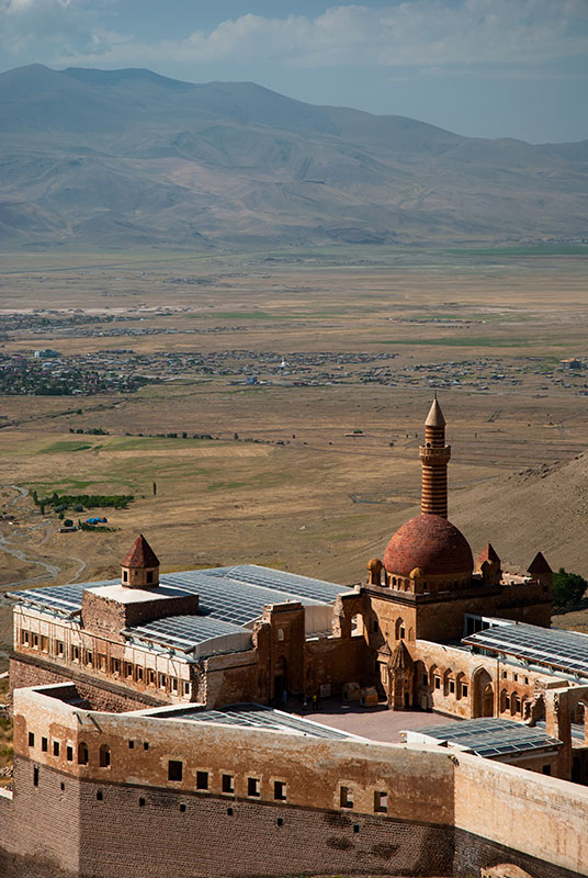
İshak Paşa Palace, Doğubeyazıt, Ağrı Province, Turkey
Perched in the mountains south of Doğubeyazıt sits the seventeenth century İshak Paşa Palace, an extravagant melange of Ottoman, Seljuk, Armenian and Persian architectural styles overlooking the plain. Although an unsightly glass roof has been built across much of the palace since my previous visit in 2003, the view remains almost impossibly romantic with the palace’s exuberant red dome and piercing, banded minaret sitting high above a wide valley backed by hazy mountains. It’s an iconic image of Turkey and, sitting just next to the country’s busiest border crossing with Iran, an iconic stop on the Asian overland trail. I drive up to the palace and stay overnight in a campsite where a few other foreigners are breaking long overland journeys. In the morning I have a walk around the palace and the mountains behind it where there are a few traces of an Urartian city, but the views never seem quite as good as I remember from eleven years earlier. Perhaps it’s the light, but I suspect one shouldn’t revisit places which stand out so romantically in the imagination.
I drive south from Doğubeyazıt towards Lake Van, passing fields of black lava where Kurdish children play in crystal-clear mountain streams. After crossing a pass, the road descends towards the inky-blue lake, which on a sunny day is eye-catchingly beautiful. I drive up to the Urartian site known as Ayanis Castle where large, finely carved blocks of black basalt bear beautiful cuneiform inscriptions, then spend the afternoon driving around the south-eastern shore of the lake, turning off the main highway to the tiny village of Altınsaç in the early evening, beyond which I climb into a tranquil valley of fragrant junipers overlooked by the ruins of the Armenian Saint Thomas Monastery, high above the lake shore. It’s a perfectly still and silent night under a star-filled sky and I have one of the best nights of outdoor sleep that I can remember.

Lake Van, Van Province, Turkey
In the morning I climb up to look at the ruins of what once must have been a very beautiful church; structurally still largely intact, but missing some of its characteristically Armenian fine stone rendering. Signs of deliberate destruction from treasure-hunting local looters can be seen and the rather fetid, dank interior now has the unmistakable odour of cattle. It’s a rather ignominious decline for a structure which is of a far higher quality of construction than anything in the surrounding villages.
I backtrack along the shore with stunning views across the lake’s shimmering deep-blue water, and stop at a small ferry dock just off the main highway to take the boat to scrubby Akdamar Island (Ahtamar in Armenian), once the seat of an Armenian Catholicosate. Here one finds the beautiful tenth century Cathedral of the Holy Cross, built from pink tuff, with a large conical dome and tall bas-reliefs of Biblical scenes such as David fighting Goliath. Now a museum and tourist attraction, the Cathedral has been the subject of serious controversy and is emblematic of the hugely contentious issue in modern Turkey of Armenians in Anatolia; itself one of the most important political problems in the region.

Cathedral of the Holy Cross, Akdamar Island, Van Province, Turkey
The line of Ancient Armenian kingdoms in Eastern Anatolia came finally under Ottoman rule in the sixteenth century, and although facing persecution as second-class citizens, Armenians remained a significant minority. However, as the Ottoman Empire began to collapse in the early twentieth century, a policy of Anatolian de-Christianisation was applied, leading to the deliberate extermination of Armenians and other Christian groups such as Assyrians and Greeks. Massacres and forced labour of Armenian males culminated in ‘Death Marches’ of men, women and children into the Syrian Desert to the south. It is estimated that one and a half million Armenians perished, with many more fleeing to form what is today a huge diaspora.
Heavily de-populated and almost entirely Kurdish, Eastern Anatolia fell into cultural decline. Akdamar Island became a military training ground and the cathedral was subject to vandalism, even being used for target practice. Narrowly escaping demolition in the 1950s, it was eventually restored in 2006, though the question of holding a liturgy or raising a cross on the roof became the subject of protests and turned into a contentious political issue. While across the border in the Islamic Republic of Iran, roundly vilified in the western press, Armenians are free to worship and erect crosses on churches, here in Turkey, nominally a secular, democratic republic, an ugly mixture of religious intolerance and chest-pounding nationalism turned such a triviality into a national incident, and highlighted an ongoing, official agenda to eradicate Turkey’s Armenian history.
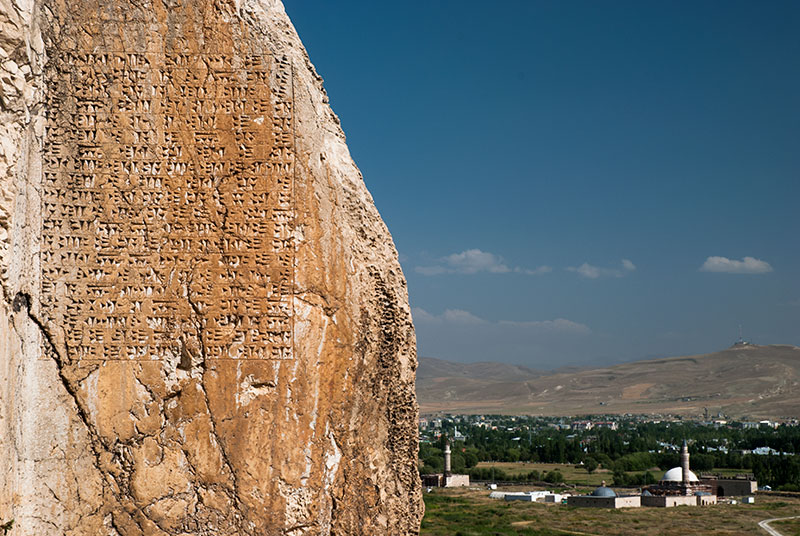
Ruins of Tushpa, Van, Van Province, Turkey
In the afternoon I stop in Van, a scruffy and rather characterless Kurdish city, but visit the fine ruins of Van Castle, site of the Urartian capital of Tushpa. From this ridge overlooking the lake, the Urartians controlled the Armenian Highlands in the ninth century BCE, their presence evident today in the form of extensive cuneiform inscriptions, including a large panel by Persian King Xerxes the Great, and a large rock-cut tomb which I am lucky to enter with some visiting archaeologists. In the evening I am hosted by Mehmet, a local Kurdish teacher with whom I talk at length about life in the area. Though not eradicated in the same way as Christians at the end of the Ottoman Empire, the Kurds have long been subject to persecution in modern Turkey and since the 1980s this region has been the centre of a smouldering conflict between Kurds and the Turkish authorities, who have historically denied the Kurds their ethnic identity in a continuation of the ‘Turkification’ of Anatolia. As beautiful as the landscape of this region appears, the underlying demographic tragedy seems to become ever more obvious as I travel. The Kurds however are undoubtedly a highlight among this. I am yet to meet people who are kinder, more generous or more welcoming.
Highway D400, Yukarİarus, Şırnak Province, Turkey
I leave Van the following day, heading east and stopping in the village of Çavuştepe where, again on a ridge there are the ruins of an eighth century BCE Urartian palace, which according to Armenian folklore was built by Hayk, legendary founder of the Armenian nation. The quality of the 2750 year-old stonework is magnificent, setting an architectural precedent for the Armenian masters who dotted the highlands with graceful churches. Turning south the road passes a dramatic Kurdish Castle which towers above the village of Hoşap, then twists through narrow valleys between towering mountains. I turn off into the city of Hakkari, which is rather bland and shambolic but located spectacularly above the valley in which the road runs. I drive straight out of Hakkari up into the mountains, crossing a 2700 metre pass to reach the village of Konak. Depopulated of Kurds in the 1980s, the site of the forcibly abandoned village is a beautiful green upland, but I have come to see the ruins of the Mar Shalita Church. A stone box from the outside without any dome or bell tower, walls plain aside from tiny slot windows and a few intriguing geometrical bas reliefs, the interior has a fine vaulted stone ceiling and a carved stone nave wall with a large, arched opening to the sanctuary and a smaller one to the sacristy on the right. This silent ruin was, until the Assyrian Genocide of 1918, seat of the Assyrian Church of the East; ancient followers of the Nestorian Doctrine unincorporated into any other Christian denomination, and whose diasporic seat is now in Chicago.
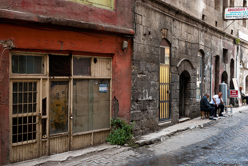
Street, Bİtlİs, Bİtlİs Province, Turkey
From Hakkari the road heads south-east through dramatic mountains scenery, approaching the Iraqi border then winding down on a spectacular section of road to parallel the Little Khabur River, which here marks the border exactly. Being so close to the border, deep inside the insurgent south-east, the military presence is very pronounced with frequent roadblocks and armoured vehicles speeding through the Kurdish villages, a reminder of just how militarised a state Turkey is. Heading west along the Iraqi border I pass through a landscape of sparse oak forest similar to the Zagros Mountains of western Iran, passing through the nondescript provincial capital of Şırnak and continuing north-west past Siirt, close to the sweltering lowlands of Mesopotamia, then climbing once more north-east back towards Lake Van. In the morning I stop in the city of Bitlis, which comes as a relief after all the scruffy, forgettable cities I have so far passed through in Turkey. Bitlis winds around a steep river valley with just a couple of parallel streets and houses spreading up the valley-sides, often of high quality stone-masonry. Dotted throughout the town are examples of austere, stocky Ottoman-era mosques, medreassas (seminaries) and turbesi (shrines) whose heavy, militaristic architecture is executed in coal-black basalt. In the centre are time-worn streets of old shopfronts with groups of friendly men sitting out on the pavement, chatting and drinking tea. I like Bitlis.
Just outside Bitlis I drive up to the village of Değirmenaltı, home to a number of Armenian khachkars, ‘cross stones’; highly decorative memorial stelae which are very distinctive of Armenian culture. Değirmenaltı is a squalid village made partly of slowly crumbling Armenian stone houses, partly of rude, modern Kurdish dwellings. I find the three metre high, ornately carved khachkars near a crumbling church, just next to a recently built house. A troop of feral-looking children are throwing stones at each other in between staring at me whilst I take photographs. One boy of about twelve, sensing my interest in the historical monuments, prises a piece of masonry from the crumbling church (which is being used as a barn) and throws it at one of the khachkars. Nothing in this part of Turkey more clearly illustrates to me the cultural decay of Eastern Anatolia than these ragged urchins; children of the peasants in their impoverished modern hovels, marginalised by the central government, living in and around the finely crafted homes and monuments of their long-evicted Armenian forebears.
Lake Nemrut, Bİtlİs Province, Turkey
I reach the western edge of Lake Van once more near the city of Tatvan, turn north and climb on a newly paved road up to the volcanic crater of Mount Nemrut (Nimrod). Crossing the crater rim, I enter a small sanctuary of greenery in this otherwise arid landscape. Underfoot is an almost tundra-like growth of fragrant mosses and shrubs, overlooking a deep-blue lake contained within the steep crater walls. I descend into the crater which is partly filled with lush green forests of birch and aspen, and drive to the far edge of the lake, parking up on a scree slope above the lake’s northernmost point. As I sit in the truck reading and admiring the scenery, clouds gather over the crater and a storm breaks, a magnificent sight. In the morning the skies are clearer again, and the air incredibly fresh and fragrant, a very pleasant change after days of driving through the torrid far south-east.
I take a different route out of the crater, ending up on the highway again and soon reaching the town of Ahlat. Here one finds a huge medieval Islamic graveyard with fine, intricately carved tomb stones of pink tuff, patinated with white lichen and often leaning distinctly off-vertical. Whilst the graves are Islamic, the masons were almost certainly Armenian given the similarity of style and stonework. Several larger mausoleums may be found amid the fields of gravestones, and south of the road is the fine, deep-red Ulu Cumbet (great dome), a conical roofed round structure, where I am followed by a pack of begging children. Ahlat was once a centre of culture on the Silk Road between Constantinople and Bukhara, but the fine monuments to this past are in total disconnect to the surrounding poverty and evoke again melancholy, compelling me to leave.

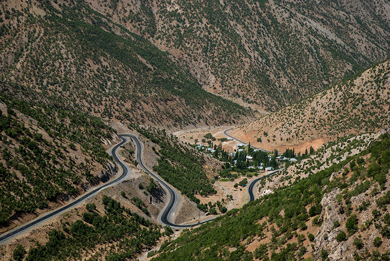
Kurdish Shepherds, near Kağızman, Kars Province, Turkey
The road follows the northern shore of Lake Van, passing the harbour town of Adilcevaz where white deposits on the shallow lake bed give it the appearance of a shelving tropical lagoon. Not far beyond I turn north, climbing through Patnos whose name suggests Greek heritage, but which turns out to be just another scruffy Kurdish town. I camp beyond Patnos and continue the following morning, passing through the regional capital of Ağrı (the Turkish name for Ararat) and then climbing on a dirt road into a beautiful landscape of green pastures dotted by Kurdish shepherds with white, conical tents. Cresting a pass, the road drops down through poplar-filled valleys amid eroded red and purple volcanic hills, joining the Aras River once again, then turning north, climbing continuously until reaching a beautiful high, flat grassland at around two thousand metres elevation, backed by low, flowing hills and looking far more like parts of Mongolia than any landscape I have recently encountered.
Kars is a raffishly charming place with potholed streets and the occasional gutted or collapsed buildings in the city’s central blocks, but with women rarely wearing headscarves and a handful of turn of the century Tsarist Russian architecture dating from the forty years under which the city was part of the Russian Empire, Kars feels very different from the conservative and shambolic cities of the south-east. The city’s population is mixed Turkish and Kurdish, but I see the word ‘Kafkaz‘ (Caucasus) often written in names of local businesses and imagine there are plenty of Armenian, Georgian and perhaps even Russian genes in the city’s populace. It’s a nice place to spend a day, with an excellent museum and a rambling castle overlooking the city, the subject of numerous Russian sieges in the nineteenth century.
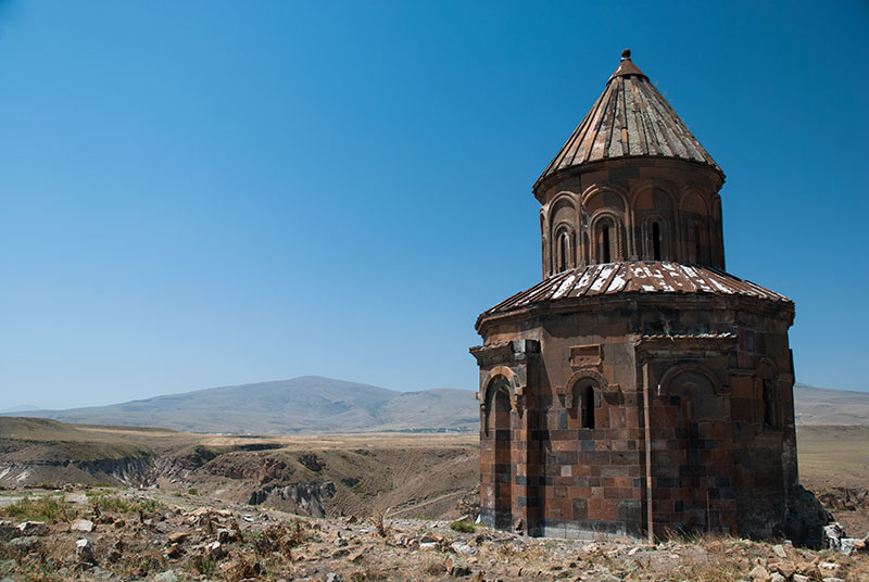
Saint Gregory of the Abughraments Church, Ani, Kars Province, Turkey
The highlight of the region however is the ruined ancient city of Ani, capital of Bagratid Armenia between 961 and 1045 with a population that may have exceeded one hundred thousand; a huge city in the medieval world. Ani was sacked by the Mongols in 1236 (who had failed to capture the city ten years earlier), then devastated by an earthquake in the early fourteenth century, leading the once great city to become a half-forgotten village, and then an enigmatic ruin. I had visited Ani in 2003 and was mesmerised by the beauty of its dark red and black churches, set in wildflower-filled meadows on the very edge of the country, overlooking the Arpa River which marks the border with modern Armenia. Photography in 2003 was forbidden, much to my frustration, but with mindless state paranoia evidently somewhat diminished, I am now free to photograph the somnolent ruins and thus realise something of a frustrated ambition.
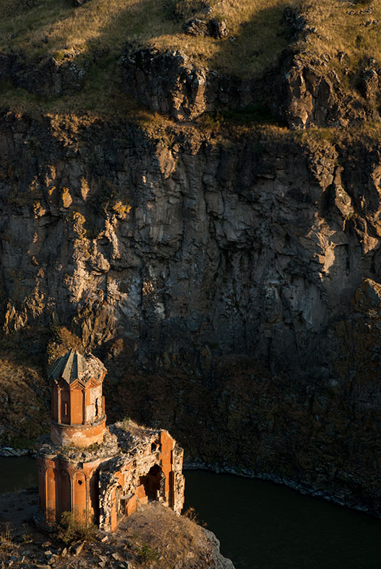
Chapel of Hripsimian Virgins, Ani, Kars Province, Turkey
One enters the city through a gate in the towering pink tuff walls which surround it, closing it off against the steep river valley. Inside is a huge plain of long grass dotted by a few largely intact structures, the stumpy ruins of many more, and everywhere piles of broken stones. I first pass the ruined base of the huge King Gagik’s Saint Gregory Church, once a huge, arcaded rotunda but now just stumps of columns with the odd fallen capital whose almost Celtic swirls are covered in bright orange lichen. Next is the Saint Gregory Church of the Abughamrents, a pleasing pepper-pot church which is the most intact structure of in Ani. Getting close to the river there is the chimney-like minaret of a ruined mosque whose exact origin is unknown and beyond, the scant remains of a citadel on a piece of high ground. From here, one can look down something of a salient of Turkish territory to the farthest-most structure of Ani, the Virgin’s Castle, a monastery which was the last part of the city to be inhabited until the monks finally left in the eighteenth century.
Other noteworthy ruins are the Ani Cathedral, a huge structure whose tambour has vanished, but which retains soaring walls and pillars of pink tuff and black basalt; the bisected shell of the Church of the Redeemer, and the Church of Saint Gregory of Tigran Honents with beautiful exterior stonework and relatively well preserved frescoes on its interior walls. My favourite monument however is the poignantly beautiful Chapel of the Hripsimian Virgins, part of a heavily ruined monastery on a cliff-top overlooking the Arpa River, near a long-collapsed stone bridge. It’s a beautifully slender structure with a delicate faceted roof, covered in damaged pink tuff rendering which glows a warm orange in the evening light. I find these monuments overlooking the river particularly tragic; forgotten at the far end of a country which seems set on total cultural cleansing of its Armenian heritage, overlooking the isolated modern state of Armenia.
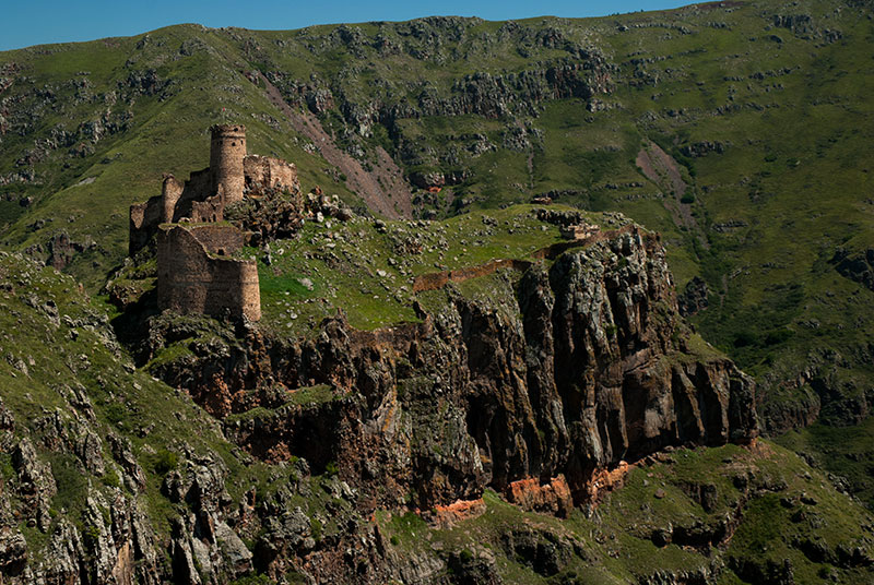
Şeytan Castle, Ardahan Province, Turkey
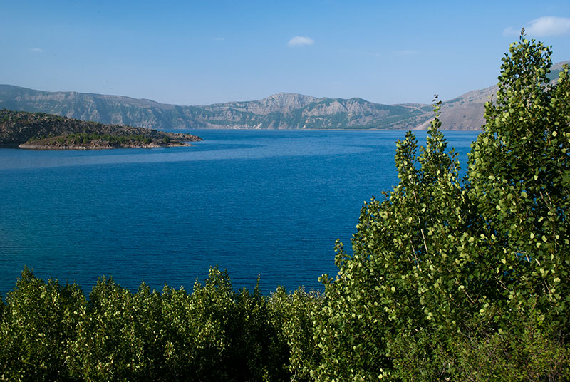
I camp for the night just outside of Ani, in the fields to the north of the city from where I have a clear view of the scale of the imposing, red-orange city walls. In the morning I set off through the quiet nearby villages, stopping at the beautiful Karmir Vank (Red Church) which is being used as a barn in the village of Bekler and has dung patties stacked against its wall, then cutting north across the fields to reach the Kars – Gyumri Highway, which would be a busy international border crossing if the border with Armenia had not been sealed since 1993. Further north I pass beautiful Lake Çıldır, close to the point where the borders of Turkey, Armenia and Georgia meet, and stop briefly at the spectacularly located Şeytan (Devil’s) Castle, poised above a vertiginous incised meander of the Kara River. The road turns north again just short of the provincial capital of Ardahan, through very attractive countryside of rolling green hills dotted with stands of pine forest, then crosses a pass and drops into the neat farmland of the Karaman Valley, where I leave Turkey to enter Georgia.
I leave the Armenian Highlands with mixed feelings. At once very beautiful and rich with history, I find it personally rather tragic how the world’s historic legacy can be erased for the sake of vein, puerile nationalism. The painful human history of ethnic cleansing and of the ongoing oppression of minorities weighs heavily on the land, and on me. I look forward to the coming weeks of uncomplicatedly beautiful scenery in the valleys of Georgia.
