
Stage 38 – Armenia & Nagorno Karabakh: The Lesser Caucasus [1/2]

Through no deliberate design, the small, mountainous country of Armenia was the only of the Soviet Union’s fifteen component republics which I had not visited on my initial four and a half year journey. I had occasionally come across Armenian culture, usually in the form of distinctive stone churches in Iran or Turkey (and also in Syria and Israel on an earlier trip in 2006) and had even peered over into Armenia (then a wholly unknown country to me) from the ruined city of Ani in 2003, on my first trip across Asia. The country itself however remained a small blank in the map which I was keen to fill.
It was therefore with considerable anticipation that I approached Armenia, which would be the first time on this second part of the Odyssey that I would visit a country which was wholly new to me. As I drove around both Armenia and the de facto independent state of Nagorno Karabakh, I would find a landscape of mostly severe volcanic plains, quite different from the lush, bountiful, exotically beautiful valleys of Georgia, but rich with the distinctively beautiful forms of Armenian medieval church architecture. The Armenian people would also stand out, proud of their long though recently rather tragic history, dignified and deeply welcoming despite the obvious poverty which their isolated republic has fallen into since the collapse of the Soviet Union.
This first half of my journey through the Lesser Caucasus would take me on a meandering route through the north of Armenia, crossing the church-dotted centre of the Armenian Highlands, through the valleys of the far north-east and down to beautiful Lake Sevan, then across the volcanic Geghama Mountains and up Mount Aragats, modern Armenia’s highest peak. Heading south from here I would enter the real heartland of the country, the Ararat Plain, stretching along the Aras River where distant Mount Ararat hangs beyond the border in the haze above both the city of Vagharshapat, seat of the Armenian Apostolic Church, and the nearby modern capital Yerevan where I would break my journey.
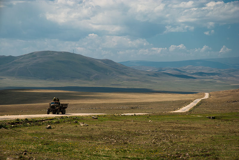
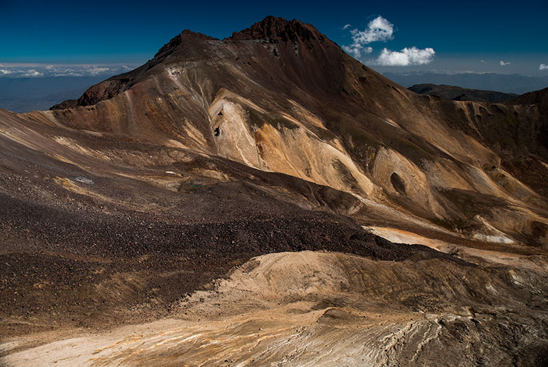
Landcsape, near Musayelyan, Shirak Province, Armenia
I enter Armenia on the 4th September 2014, crossing from Georgia at the village of Gogavan late in the afternoon and soon pulling off the road to camp in a field, watching a storm descend from the mountains off to the east. After at least eight years of having the intention to visit Armenia, I am here, and the view in front of me is much as I had imagined to country to look, based mostly upon my first glimpse from across the Turkish border more than eleven years ago; attractive, rolling steppe and soft, low mountains which now fade into the dark, back-lit storm clouds.
In the morning, after a few errands in the small town of Tashir, I head east across the rolling upland which I had looked out upon last night, crossing a low pass and slowly descending past isolated villages of pink tuff houses, crossing the main road to Gyumri and joining the Akhurian River which here runs parallel to the Turkish border. Driving south on rough, decayed Soviet-era roads I eventually reach the beautiful Marmashen Monastery, on a grassy riverbank of the Akhurian, surrounded by fruit trees. Built of orange tuff, the monastery is centred on the beautiful eleventh century Katoghike (Holy Mother of God) Church, with a characteristically Armenian faceted umbrella roof, and tall niches on its external walls; contemporaneous with the churches of Ani but in far better condition; particularly pleasing to see given the neglected state of Ani’s buildings.
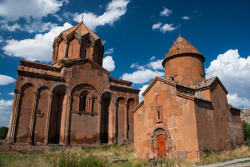
Marmashen Monastery, Shirak Province, Armenia
From the monastery it’s a very short drive south to reach the rubble-strewn northern suburbs of Gyumri, Armenia’s second city, where I pass a mixture of bulldozed city blocks, abandoned, half-built apartment buildings and various barracks making up a large Russian military presence, with each of these being symbolic of Armenia’s turbulent recent history.
The 1988 Spitak Earthquake had its epicentre just thirty five kilometres from Gyumri, killed between twenty five and fifty thousand people and came at a time when Gorbachev’s reform in the Soviet Union had lead to a greater expression of nationalism. This freedom however also allowed simmering ethnic conflicts to erupt, which in the South Caucasus republics lead to an outburst of repressed tension and conflict between Armenians and Azerbaijanis in both republics. Internally displaced people had arrived in Armenia at the time of the earthquake, which in addition to the low-quality Brezhnev-era apartment blocks caused a huge death toll from the magnitude seven earthquake.

Gyumri, Shirak Province, Armenia
The collapse of the Soviet Union in 1991 spelled economic chaos for Armenia (and indeed every part of the Former USSR), but was accompanied by the outbreak of full-blown conflict in the Nagorno Karabakh War, which raged until 1993 and saw Armenia and Azerbaijan fighting over the historically Armenian region of Nagorno Karabakh, which was ceded by Stalin to Azerbaijan in 1928. The conflict, in a wider sense, can be seen as part of Russia’s age-old antagonism with the Turks and, with Russia siding with Armenia, gave ample opportunity for Russia to retain a large military presence in this lost territory, strengthening its very sensitive former border with NATO and retaining a toe-hold in the South Caucasus, an area always coveted by the Turks.
Gyumri’s name may be of Urartian origin, but the city is relatively modern and reminds me very strongly of Kars in neighbouring Turkey, with turn-of-the-century houses of black tuff, a feeling of decline and shabbiness, but a pleasant atmosphere nevertheless. Gyumri must once have been a very attractive city, in its former incarnations as Alexandropol in the nineteenth century and Leninakan in the twentieth, but the earthquake and general poverty and decline have all clearly taken their toll.

Jrapi Caravanserai, Shirak Province, Armenia
I leave Gyumri in the early evening through scruffy suburbs of rusting industry, joining the Akhurian River which now marks the sealed border with Turkey. Once out of the city, I am back in the familiar rolling steppes on which the ancient Armenian capital of Ani is located, just across the river. The border region itself has the unmistakable signs of having been one of the sensitive outer borders of the USSR, with T-shaped barbed wire fences, multiple power and telegraph lines, an anomalously wide road which could double as a runway and watchtowers overlooking the gorge of the Akhurian. Ironically, the point on the border exactly opposite Ani is still occupied by the Russian Army and off limits to casual visitors.
There is however a beautiful monument of the Silk Road, a branch of which would have passed through Ani and into modern Armenia, in the form of the eleventh to twelfth century Jrapi Caravanserai; a long, low building missing much of its roof, revealing attractive, heavy arches of pink and black tuff. A little further south, in the pumice-mining village of Anipemza one finds the remains of the huge, fourth to sixth century Yererouk Basilica, one of the earliest extant examples of Armenian architecture. Yererouk is of importance not just for its great age and size, but also for the Greco-Roman influence which can be seen in the five-stepped plinth on which it sits, and the columns and pediments of its entrance portals, giving an insight into the form of early eastern Christian architecture.

Maralik, Shirak Province, Armenia
I leave the Turkish border area, heading east from the main road, passing through the village of Sarakap on a rough track into the hills, then through Karaberd which appears to be a semi-deserted farming village, dropping into the small town of Maralik on whose eastern edge is a huge, Soviet-era cotton-spinning plant, located improbably far from the source of cotton in Central Asia and operating at a fraction of capacity. In the next small town of Artik, I stop to visit the small, almost pencil-like seventh century Lmbatavank Monastery, which sits overlooking the town on a hillside strewn with broken carved tuff coffins. A simple cross-church, Lmbatavank nevertheless shows the distinctively Armenian dome and slender form, marking a departure from the earliest Greco-Roman and Byzantine influenced churches.

Harichavank Monastery, Shirak Province, Armenia
In the nearby village of Harich, I drive up between simple farmhouses to the striking Harichavank Monastery whose main building is an amalgamation of seventh and thirteenth century churches, the latter having a very fine sixteen-sided tambour and faceted umbrella dome, representative of a golden age of monastery building in Armenia. The monastery has a nice, lively atmosphere with a large family group celebrating a baptism service, picnicking in the monastery’s grassy grounds. Walking inside, I catch the end of the service, which seems to be a joyful event with none of the stiffness I had noticed in Georgian church services.
My route then takes me east along the northern slopes of Mount Aragats, Armenia’s highest peak, turning north again and crossing a low mountain range. I stop for a late lunch in the completely rebuilt town of Spitak, close to the epicentre of the 1988 earthquake, before continuing east towards Vanadzor. The road enters the Pambak Valley which is filled with a concentration of moribund, rusting, Soviet-era industry which seems totally at odds with the rugged mountains and small villages which typify the area. Before reaching the city proper I turn north, climbing and entering a tunnel under the Pushkin Pass, so named as it was here that Pushkin encountered the body of Griboyedov, killed in Persia in 1829, being transported back to Russia. Turning east again I drive through more small farming villages, and camp for the night on a grassy hillside overlooking the village of Kurtan, which sits on black cliffs overlooking the Dzoraget Valley.

Debed Canyon, Lori Province, Armenia
In the morning I enter the Dzoraget Valley, passing the partially restored Monastery of Hnevank which is picturesquely sited on a forested hill, and descending on a rough, washed-out road to meet the Debed River. The Canyon of the Debed is a major transport artery northwards towards Tbilisi, and is also the site of some of the country’s finest monasteries. The valley’s largest town is Alaverdi, attractively set in a sweeping curve of the canyon and filled with neat rows of Soviet-era pink tuff apartment buildings, but centred around a large copper smelting plant which emits a continuous haze of pollution into the hills above the town. The town centre is like a living scene from an old Soviet photograph, with rows of tatty PAZ buses, rusting cable cars to bring workers down from the in the hills above, and a univermag; or state-run department store; all seemingly unchanged since the 1980s. Overlooking Alaverdi from the south side of the river one finds Sanahin Monastery, centred upon the tenth century Mother of God Church with a large, beautiful, conical dome and a gavit (Armenian form of narthex) containing fine stone carvings and distinctive khachkars (intricately carved memorial stele).
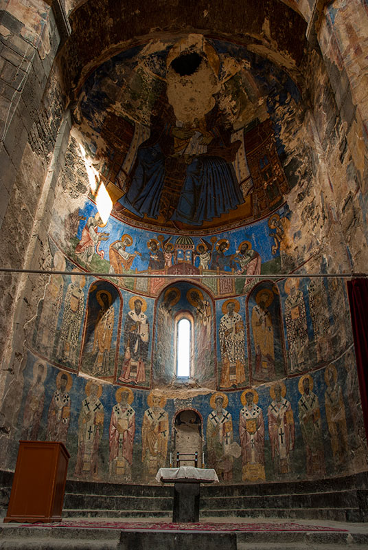
Frescoes, Akhtala Monastery, Lori Province, Armenia
Equally interesting are the lives of two brothers who hail from the small village of Sanahin; Anastas and Artem Mikoyan. Anastas, the older of the two was a Bolshevik who survived the purges of the pre-war years, outlasting Lenin, Stalin and Khrushchev to become the longest serving member of the Politburo. Artem was behind some of the Soviet Union’s most successful early jet fighters, and a mothballed MiG-21 sits as monument outside the Mikoyan Museum.
Beyond Alaverdi, heading once more east, I make two side trips; first to Haghpat Monastery, set on a grassy hillside and similar in age and style to Sanahin with very finely carved khachkars but also with a distinctive thirteenth century bell tower. The second is Akhtala Monastery, situated within the ruins of a tenth century fortress overlooking the road as it begins to loop northwards towards the Georgian border. Akhtala’s Mother of God Church, which has lost its dome, is a thirteenth century basilica and was in fact built as a Georgian church. I speak to a nearby shopkeeper who is also the key-holder to the church, and he admits me into the interior where magnificent frescoes cover many of the interior walls; most impressively in the apse where a defaced Virgin Mary sits enthroned above rows of saints.
Beyond Akhtala the Debed Valley opens up as it drops towards the lowest point in Armenia, and when the river swings westwards to demarcate the Georgian border, I continue eastwards towards the border with Azerbaijan. The road turns south once more, crossing successive ridges until it pulls exactly level with the de jure border. Although the border here is not technically disputed, since the Nagorno Karabakh War, its various exclaves and salients have been smoothed somewhat, with each country (though more so Armenia) occupying territory formally belonging to the other.

Aşağı Askipara (Destroyed), Voskepar, Tavush Province, Armenia
I stop on the edge of the village of Voskepar where the beautiful seventh century Church of Saint Sarkis sits exactly on the border line. Immediately beyond, in Azerbaijani territory are the ruins of the village of Aşağı Askipara, destroyed by Armenian forces in 1989 and occupied since 1992. It’s a sobering sight, with the ruins of civilian homes dotted on a scorched hillside beyond the intact church; a graphic reminder of the intensity of hatred between ethnic Armenians and Azerbaijanis. Shortly after there are glimpses of views into Azerbaijani territory, where Mount Göyazan, a striking rock monolith, sits beyond the blue waters of a reservoir, before the road passes the occupied Azerbaijani exclave of Barkhudarly. I leave the main road here, winding into the hills above the village of Achajur, entering beautiful forest and camping under a full moon in a field next to the Monastery of Makaravank, which seems somehow remote from the horrors of the front-line.
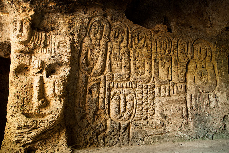
Petroglyphs, Anapat Cave, Tavush Province, Armenia
In addition to its beautifully serene location, the tenth-to-thirteenth buildings which make up Makaravank Monastery have some of the finest stonework in Armenia, and are all executed in pink tuff or andesite. The main, early thirteenth century Mother of God Church has an altar carved with geometrical and floral patterns very similar to those seen in Persian mosques and mausoleums, and an exterior whose smooth pink stone is delicately carved into window niches, blind arches around a circular tambour, and fine decorative pieces such as the sundial on the southern wall.
Rejoining the main road heading southwards and turning off at the edge of the town of Ijevan, I climb into the hills and park the truck at the edge of a holiday resort which marks the end of the track. I walk into thick, beautiful woodland of oak and hornbeam, dropping after some time into the gorge of the Sarnajur River, which has been carved out of the native limestone. Here one finds a series of natural caves, said to have been inhabited in ancient times and a place of refuge during the Mongol invasions. One of these, known as the Anapat Cave, is richly carved; most strikingly with a large mask-like face which looks almost pre-Columbian American in style, with six human figures standing next to it. Crosses are found carved elsewhere in the cave, but the mysterious portraits are allegedly pre-Christian.

Lake Sevan, near Drakhtik, Gegharkunik Province, Armenia
Some distance south of Ijevan, I leave the main highway, which leads to the capital, and turn eastwards, climbing steadily along the beautiful Getik Valley, then south across rolling, treeless grassy hills, finally dropping down in the beautiful late afternoon light to the shores of Lake Sevan. At 1900 metres elevation, Sevan is the highest of three large alpine lakes in the region (Van and Urmia being the others) and its dark blue waters, ringed by mountains, are spectacularly beautiful. I drive a little down the coast, looking for a campsite until I spot a distant promontory. After driving down a dusty track, I have to negotiate a ploughed field, then tractor up a steep grassy hillside in low-gear, but the truck reaches the top without hesitation and I am rewarded with a glorious, solitary campsite above the lake, with panoramic, 270 degree views across its shimmering cerulean waters towards the ridges of the Geghama Mountains to the west. Cooking dinner whilst watching the sun set, I am once again living my dream, using the capabilities of the truck which I have recently spent so much time and effort in restoring.

Armenian Woman, near Tsaghkashen, Gegharkunik Province, Armenia
After a beautiful night sleeping under the stars, I drop back down to the lake, and after a refreshing dip in the water, drive north along the attractive north-eastern shore, which is lined by rows of pines on sandy beaches from where fishermen launch small boats. Rounding the northern tip of the lake, the road leads to the town of Sevan where I stop at the Monastery of Sevanavank. In contrast to my tranquil overnight stop, the monastery is crawling with tourists, trinket sellers, hawkers and beggars. The smell of greasy food hangs in the air and cheap Russian pop music can be heard over the sounds of jet skis on the lake below. It’s rather far removed from the dignified monasteries hidden out in the villages; all the more ironic given that Sevanavank is one of Armenia’s few still active monasteries.
Escaping the tourist circus, I continue down the western shore of the lake which is far less attractive than the east coast with a scrubby, low-lying littoral. I stop at the Monastery of Hayravank, whose interior of orange and black tuff stones is dimly lit by a skylight in the dome of the main twelfth century church, and where I witness a family sacrificing a chicken just outside. Further south I stop at the medieval cemetery of Noratus, where dozens of beautifully carved khachkars and tombstones, some engraved with the objects and activities of the deceased who are interred below, lie in glorious isolation and mostly coloured bright orange by the growth of lichen.

Geghama Mountains, Kotayk Province, Armenia
I wish to make my way westwards via the Geghama Mountains which separate Lake Sevan from the central part of the country, and so drive from Noratus up into the foothills, to the village of Tsaghkashen. I stop to ask directions from a house in the village, and as well as pointing out the path ahead, the family fill my bottles with drinking water and hand me a sheaf of fresh lavash; paper-thin Armenian bread, fresh from the oven. A track leads up and out of the village, into grassy hills filled with the summer camps of cow and sheep herders. I stop frequently to ask directions, at one point being invited for a cup of sweet black coffee from by a mother and son who are staying in a wagon high in the hills. The track as such soon disappears however, and I am left crawling through deep ruts and over rocks, and it’s after sunset by the time I finally find a track which heads high into the mountains. I follow the track carefully in the dark until it levels out at just over three thousand metres, then stop and camp for the night.

Mount Ararat from Mount Aragats, Aragatsotn Province, Armenia
I wake after a cold but pleasant night on a beautiful, grassy, volcanic plateau, with several soft, ancient cinder cones to the west, whose dark red rocks are in places delicately shaded by green grass. The track ahead soon disappears again, so I climb a ridge on foot and plan my way forward through fields of boulders to the blue waters of nearby Lake Akna, where I hope to find another track running south-westwards to the village of Geghard. Despite crossing trackless terrain, the drive is straightforward but after considerable searching in the vicinity of the lake, I see that there is only one track, leading westwards towards the provincial capital of Abovyan. Descending the rough, rocky track, I pass a string of villages, then drive through Abovyan, by-passing the northern edges of Yerevan. The road runs along the southern edge of Mount Aragats, through a landscape which reminds me of southern Crete, with orchards and fields of parched yellow grass overlooked by volcanic peaks. In the city of Ashtarak I turn north, then take a side road which joins another road winding up the slopes of Aragats, built to service the Aragats Cosmic Ray Research Station, which sits at 3200 metres under the mountain’s southern summit. Reaching the end of the road, I turn and drive a little further beyond the buildings onto a steep hillside and find a place to stop for the night.
Mount Aragats (4090 m), Aragatsotn Province, Armenia
In the morning I leave the truck on the mountainside and walk up to the southern summit which at 3888 metres altitude is the lowest and also most accessible of the mountain’s four summits. Ever visible, off to the south are the two peaks of Greater and Lesser Ararat, respectively eighty eight and ninety six kilometres away, in Turkey. The two peaks of this highly prominent, dormant volcano are deeply ingrained in the Armenian soul. For much of history they were the symbol of Armenia (they are even pictured in profile on the entry stamp to Armenia made in my passport), yet for generations they have hovered in the Armenian consciousness as a painful reminder of their tragic history, just as they now hover mirage-like in the haze, tantalisingly out of reach across a sealed border. In less than two hours I am on top of the south summit, looking across a yawning caldera of craggy, beige and chocolate-brown rock, which I have all to myself until the arrival of a somewhat elderly German tour group.

Saint Christopher Monastery, Aragatsotn Province, Armenia
After a lengthy descent, the road from Aragats leads directly to the main Yerevan – Gyumri Highway where I turn west, driving around the southern edge of the volcano towards the Turkish border. I drive as far as Mastara to see the seventh century Church of Saint Hovanes, which has never been significantly renovated and whose bulky, squat dimensions remind me of later Mongol and Seljuk architecture in Persia and Turkey. Grass grows over its broad octagonal dome, echoing its slightly forlorn location in a quiet village, set well back from the highway. I double back for a short way from Mastara, turning south and passing through Talin and the stone fortress village of Dashtadem, leaving the main road and stopping for the night on a rock-strewn volcanic terrace. In this very picturesque spot, I am overlooking the small, restored but unused seventh century Saint Christopher Church which sits on the edge of the ancient lava flows of Aragats. Beyond, to the south, the glacier on the peak of Mount Ararat is just visible through the interminable haze, gleaming in the last of the evening light.
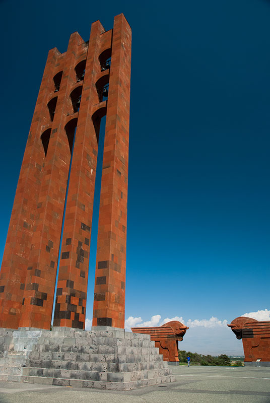
Sardarapat Memorial, Armavir Province, Armenia
Leaving my campsite after a relatively warm but windy night, I descend the volcanic hills and reach the fertile Ararat Plain, which constitutes something of a heartland of Armenia. I drive on almost empty roads to the Turkish border, climbing a ridge overlooking the red-orange landscape where the Aras and the Akhurian meet. I have a good view up the Aras Valley into Turkey, looking at a road I had hitch-hiked along more than eleven years ago. My reason to come here is that the two small villages on the border, Yervandashat and nearby Bagaran have historically both been capitals of Armenia, and I intend to have a look for any interesting remains. Dropping into Yervandashat, I get the impression that it’s unusual for a foreigner to be seen here and I am soon stopped by a young man in an official-looking car. My fears that I have strayed into a restricted border zone soon evaporate however as I am invited into the home of the mayor, whose nephew and very attractive niece both speak English, and explain to me whilst plying me with coffee and sweet slices of watermelon that nothing survives from this history, though they obviously flattered that I take an interest in it. Whilst Armenians may in some ways be regarded as European, their deep, intrinsic hospitality is undoubtedly Asian in its frankness.
I drive west out of Yervandashat passing the abandoned spur of a highway which in better times would lead to a border crossing with Turkey. Soon villages start to appear more frequently as I enter the irrigated lowlands which spread all the way to the capital. I stop at the Sardarapat Memorial, a striking fusion of Armenian red tuff and Soviet brutalist styles with winged oxen and a thirty-five metre bell tower inspired by medieval Armenian memorial stelae. The monument was constructed in 1968 on the fiftieth anniversary of the Battle of Sardarapat, which saw scant Armenian forces fight off the Ottomans, who in May 1918 were sweeping towards Yerevan following the withdrawal of Bolshevik forces from the region. Given that this was just three years after the Armenian Genocide, when Armenians had been effectively exterminated from many of their ancestral lands, a victory here for the Turks could have put an end to the Armenian state altogether, and thus the victorious battle is commemorated as having saved Armenia from being relegated to history books.
Saint Hripsime Church, Vagharshapat, Armavir Province, Armenia
From the monument I drive through the shabby regional capital Armavir, continuing east past Metsamor with its elderly Soviet nuclear power station, and stop in the city of Vagharshapat. Here I am hosted by Karine, who lives in a terraced house with a garden on the northern edge of the city, with her father, sister and niece. Vagharshapat is colloquially known as Etchmiadzin as it is home to the Mother Sea of Holy Etchmiadzin, seat of the Armenian Apostolic Church. The Church is very much central to the Armenian identity; marking Armenians out as one of the oldest Christian communities. It also marks Armenia as the oldest Christian country, with Christianity having been proclaimed the state religion in the fourth century, with roots claimed to go back to first century apostles Bartholomew and Thaddeus (Jude).
Karine, who works in the city as a tour guide, takes me to see the Etchmiadzin Cathedral, allegedly dating from the early fourth century, which would make it the world’s oldest cathedral. Having often been damaged and rebuilt however, the earliest parts of the structure now date from the fifth century, and from the exterior the undeniably beautiful stonework represents a fusion of Armenian styles from throughout the ages. Inside, the cathedral is beautifully decorated with seventeenth and eighteenth century frescoes and houses a museum, though I must admit to being more impressed by the stunningly beautiful girls staffing it, rather than by any of the aged trinkets or robes which Armenian visitors regard with great veneration.

Zvartnots Cathedral, Armavir Province, Armenia
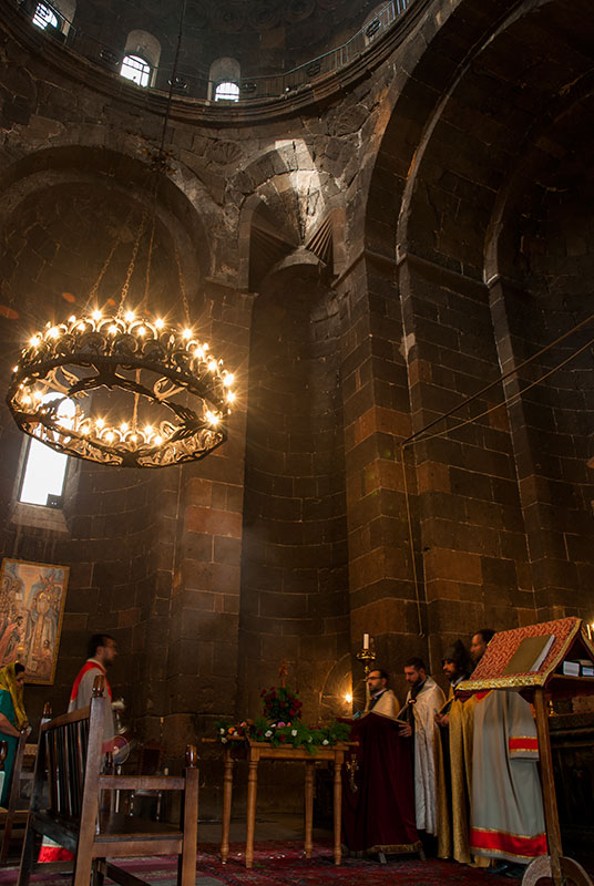
More interesting to me is the nearby seventh century Saint Hripsime Church, an elegant cross church which vies with Georgia’s Jvari Monastery as the archetype for this uniquely Caucasian evolution of Byzantine design. Karine and I enter whilst a service is going on; a robed priest is giving a sermon whilst an acolyte swings a thurible, filling the air of the church’s brooding stone interior with fragrant incense. Once again I notice a rather light-hearted air in the church, with the priest and congregation laughing as a particularly dense billow of smoke engulfs the priest, momentarily interrupting him.
In the evening Karine and I drive out to the ruins of the seventh century Cathedral of Zvartnots, whose original form is unknown, beyond the ground floor of a tetraconch surrounded by a thirty-two sided gallery, which would have looked circular. Some historians reconstruct it with three concentric tiers, like a miniature Tower of Babel, though this would have made it one of the most technologically advanced structures of its day, and might be aggrandised by the Armenian’s great pride in their own history. Whatever the reality, the rotunda of partially intact arcades on Greco-Roman pillars are quite a doleful sight as they catch the last rays of red sunlight lancing through the stormy grey sky.
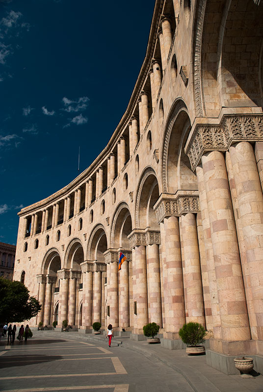
Republic Square, Yerevan, Armenia
After two nights in Vagharshapat I say goodbye to Karine, thankful both for her hospitality and her kindness in showing me around Armenia’s holiest city. It’s just fifteen kilometres to the outskirts of Yerevan, the capital, and I drive immediately to the northern edge of the city to visit the Iranian Embassy and the nearby ‘Permanent Representation’ of the internationally unrecognised Nagorno Karabakh Republic. With visa application forms collected, I drive down into the city centre and reach a backpacker hostel where I will base myself for the next week, taking the first real rest since leaving the UK more than three months ago.
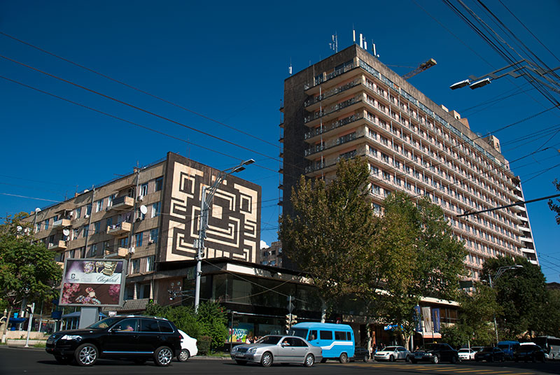
My first impressions of Yerevan are of a being a strongly Soviet city, but with distinctively Armenian architectural flourishes such as the use of pink and black tuff as in the provinces. Indeed, Yerevan expanded very rapidly in Soviet times from a provincial town of the Russian Empire to the capital of a republic. Since independence the capital has seen a small decline in population due mostly to economic migration, but also the outflow of ethnic minorities such as Russians and Azerbaijanis. Nevertheless, the city remains home to just over a third of the country’s population and with an influx of remittances from the large and often wealthy Armenian diaspora, the city contrasts starkly with the shabby provincial towns and impoverished villages. Yerevan lacks the raffish charm of Tbilisi and is rarely particularly scenic, but is feels suave, confident, prosperous and happy.
Sayat-Nova Avenue, Yerevan, Armenia
I start my exploration in the city centre, in Republic Square, which is a large, elegant, yellow tuff piece of Soviet Neoclassicism. Here one sees the usual post-Soviet nouveau riche in blacked-out SUVs; senior civil servants and businessmen milling around the central government offices. Walking generally south, I pass through some streets of terraced, late nineteenth century stone houses, then come to a large junction where the architecture is decidedly Soviet. Crossing the road, I enter the pleasant ‘Green Belt’, a strip of urban park which surrounds the eastern half of the circular city centre. Along its pathways of slightly crooked concrete slabs, mostly elderly people are packed on benches sitting, talking and reading newspapers under tall plane trees in what remains an unspoiled piece of Soviet urban planning. I walk much of the length of the park, before descending into the city’s metro system. The Soviet-era metro has a distinct feeling of under-use, with trains far shorter than those which the stations were designed for. Some of the stations are quite elaborately decorated however, particularly the Sasuntsi Davit Station, which has wall sculptures of orange tuff from Armenian folklore. I ride the metro to its southerly terminus, then walk out of the station to find scruffy, sprawling suburbs and plenty of derelict industry, but by chance happen to catch a pair of Russian MiG 29s from the nearby military airbase making manoeuvres directly overhead; a reminder that I am less than fifteen kilometres from the Turkish border, one Russia regards as its own border with NATO.
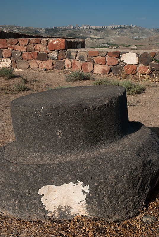
Erebuni Fortress, Yerevan, Armenia
On another day, I start in the north of the centre at Freedom Square, walking north and climbing up the Yerevan Cascade; a giant stairway with intermediate tiers of carved stonework, an unusual fusion of Soviet Socio-realism and traditional Armenian styles. The top of the Cascade appears unfinished, but after a slight diversion around a derelict building site, one reaches a viewing gallery overlooking the city centre, though Ararat remains illusive in the late-summer haze of dust and pollution. Here a lonely concrete obelisk commemorates fifty years of Soviet Armenia, and steps lead further up to Victory Park and a statue of ‘Mother Armenia’ on a towering concrete plinth housing a museum of the Great Patriotic War; all very much Soviet monuments to a past which I imagine is becoming ever less important in independent Armenia.
The city has a number of museums; sadly the Museum of the Armenian Genocide is closed in preparation for next year’s centenary, but I spend a good few hours in the National Gallery which houses a mixture of Russian, European and Armenian paintings. More interesting however is the Urartian site of Erebuni in the far south of the city. Founded in 728 BCE, Erebuni Fortress, the namesake of modern Yerevan, was an important Urartian city and today houses an excellent museum of Armenian history. The Urartians, a regional civilisation who traded with the Elamites and Ancient Greeks, are regarded by Armenians as being their cultural forebears, with many Armenian legends having apparently Urartian origins. Certainly, the Urartians’ great mastery of stonework seems to have been inherited by the Armenians. Climbing the hill behind the museum are the modest remains of Erebuni, with a few ruined column bases and some Urartian cuneiform inscriptions which an Italian archaeologist points out to me. One last museum I visit is the Mesrop Mashtots Institute of Ancient Manuscripts at Matenadaran; a repository of beautiful illuminated manuscripts and a celebration of the Armenian alphabet, the latter of which has been pivotal in the survival of the cultural identity of a people who usually lived as a minority, yet who resisted complete assimilation into the empires of the Persians, Turks or Russians.

Stonemasons. Matenadaran, Yerevan, Armenia
Aside from the city’s obvious attractions, I enjoy my time in the hostel meeting various travellers who pass through, one of the highlights of extended overland travel. Armenia is the nearest ‘free’ country which Iranians can visit visa free, and there are a remarkable number of young Iranian men indulging in alcohol and other delights which the city has to offer, often to excess. I meet Sebastian, a Swedish engineer whom I met in Samarkand in July 2011 and who is by chance spending a weekend in the city. I also befriend Ace, a young Filipino nurse living in the UAE who I will later meet again in Karabakh. Thus I spend a week in Yerevan exploring, relaxing, drinking beer and enjoying the company of fellow travellers.
This first part of my journey through Armenia has shown me many of the country’s highlights; its greatest pieces of architecture, largest cities, highest mountain and its natural jewel, Lake Sevan. The second half of my journey through the Lesser Caucasus would take me to the more rugged south, with two separate journeys into the de facto independent Nagorno Karabakh Republic, and a final drive down the spine of the country to the Iranian frontier.
