
Stage 32 – Ukraine: Podolia, Bukovina, Transcarpathia, Galicia And Volhynia

The very final stage of my four-and-a-half year Odyssey would take me across the far west of Ukraine, to the Polish border. Historically, this region has been dominated by the former powers of Lithuania, Poland and Austria, with much of the region only coming under Russian influence following the Second World War when it was formally ceded to the Soviet Union. Once a set of independent kingdoms and princely states, western Ukraine represents something of a transition zone between the steppes of Eastern Europe and the medieval cities of Central Europe. Here I would see yet another side of Ukraine; one far more westward-looking and assertive in its cultural distinction from Russia, one where Ukrainian is commonly spoken and where links with Central Europe are strong. Amid the region’s attractive old cities I would also witness the traces of a departed people; the Jews, who before the events of the twentieth century made up a sizeable proportion of the population. For me however, this final stage of less than three weeks was a farewell to the Former USSR, to my journey, and to my life as traveller, and as I passed through the regions of Podolia, Bukovina, Transcarpathia, Galicia and Volhynia I was ever conscious that this western extremity of Ukraine has historically been frontier territory, and very much a gateway to the West.

Castle, Kamianets-Podilskyi, Khmelnytskyi Region, Ukraine
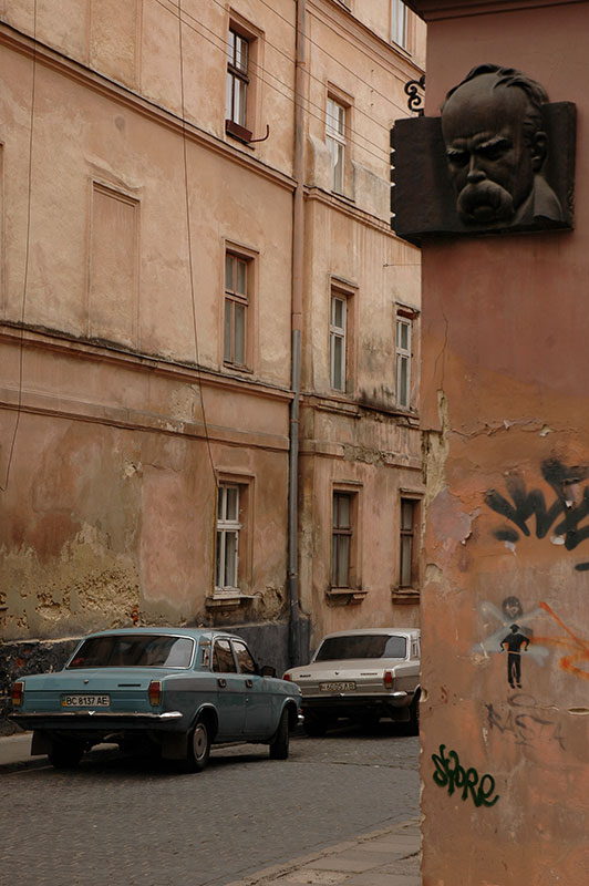
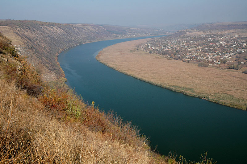
It’s a cool, damp morning on the 31st October 2011 as I drive across the Dniester River into Ukraine and the historical region of Podolia. From the border town of Mohyliv-Podilskyi I drive slowly north through backwater towns on winding and sometimes rough backroads, later turning east and reaching in the evening the attractive city of Kamianets-Podilskyi, where I am hosted by Gennadiy, a local sign-writer and his family. Kamianets-Podilskyi was first mentioned as part of Kievan Rus’, the pre-cursor state of modern Russia, Ukraine and Belarus, and was capital of Podolia from the fifteenth to twentieth centuries. Gennadiy’s apartment lies in the new city, which bears the ubiquitous architectural hallmarks of the Soviet Union, but it is in the ancient centre just a few hundred metres to the west that I realise I am somewhere quite different from the eastern and central regions of Ukraine through which I have recently passed. The old city of Kamianets-Podilskyi is situated on a bluff almost totally enclosed by a sweeping meander of the Smotrych River, which here has carved a deep, leafy gorge out of the native limestone. Here, life unfolds slowly on winding cobbled streets of pastel-coloured buildings, dotted with churches of both Orthodox and Catholic denominations, reflecting the long, historical influence of Lithuania and Poland in Podolia and indeed much of western Ukraine.

Castle, Khotyn, Chernivtsi Region, Ukraine
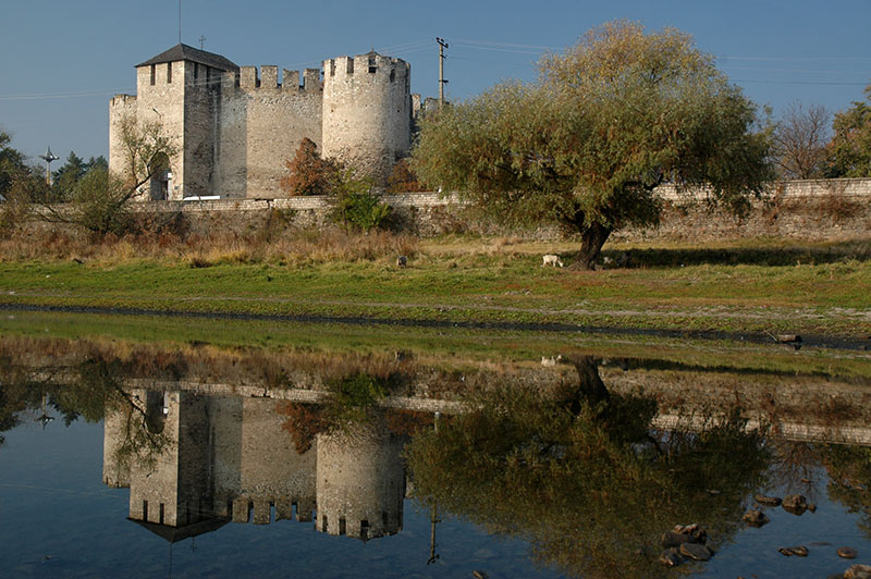
Aside from a modern bridge, the only connection between the old city and surrounding countryside is a neck of raised land, and immediately beyond this lies Kamianets-Podilskyi’s striking castle, which for centuries marked the border of the Polish-Lithuanian Commonwealth and withstood attacks from the Tatars and Ottomans, until being ceded to the Russian Empire in the eighteenth century following the second partition of Poland. Amidst the low cloud and damp, muddy Podolian countryside which lies beyond, the spectacularly sited castle paints a highly atmospheric picture of medieval Europe.
West of Kamianets-Podilskyi I meet the Dniester once more and cross briefly back into Bessarabia in the town of Khotyn which hosts another magnificent medieval castle, the last and most spectacular of a series of fortifications which have marked my journey up-river from its estuary below the windswept castle of Bilhorod-Dnistrovskyi on the Black Sea. From Khotyn, the road takes me south-west, crossing the Prut River into the historical region of Bukovina and the charming provincial capital of Chernivtsi.

Chernivtsi, Chernivtsi Region, Ukraine
Like Bessarabia, Bukovina was historically part of Moldavia, but whereas Bessarabia was annexed by the Russian Empire in the eighteenth century, Bukovina became part of the Habsburg and successor Austrian empires, and only came under Russian influence after the 1940 occupation of Northern Bukovina by the Red Army. Just across the Prut River, Chernivtsi is the principal city of Northern (i.e. Ukrainian) Bukovina, and with less than fifty years of Russian domination, feels a great deal less Russified than any other part of Ukraine I have yet visited. Here I have finally entered Western Ukraine, and begin to appreciate the stark divide between the west and east of the country. Not only is the architecture of the city decidedly different, but also the people, with bloodlines mixed with Romanians or Poles. The language is also different, with the softer tones of Ukrainian being spoken on the street; a far cry from Kharkiv or Dontesk. At once Chernivtsi feels more worldly and sophisticated, more European than the cities of the east, but it is also noticeably less smart and prosperous, for while the east of Ukraine has historically been an industrial powerhouse, these western regions are by comparison an agrarian hinterland.
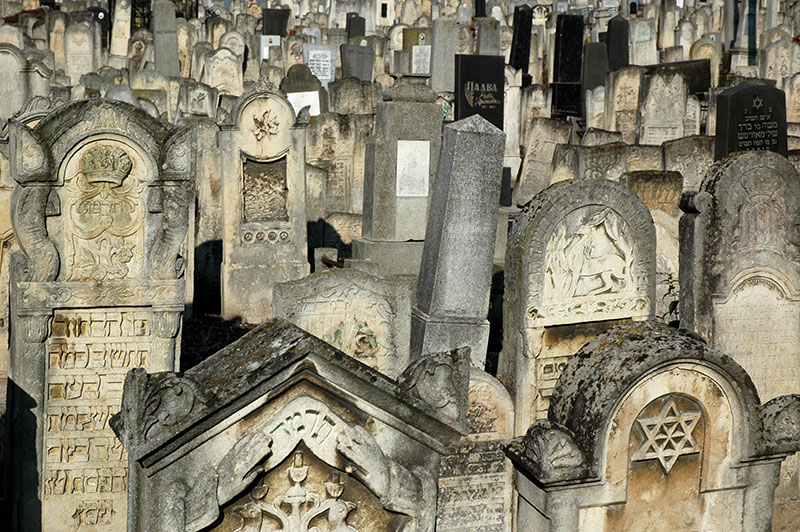
Jewish Cemetery, Chernivtsi, Chernivtsi Region, Ukraine
Known as a regional cultural and educational capital and sometimes referred to as ‘Little Vienna’ due to its Habsburg heritage, Chernivtsi lies amidst the eastern foothills of the Carpathians and is immediately attractive with its mixture of Neoclassical, Baroque and Gothic architecture. Elegant streets of nineteenth century pastel buildings with stucco facades, and numerous churches, parks and squares make for a very pleasant city to stroll in, but the city’s unexpected centrepiece is undoubtedly the huge, nineteenth century red-brick Residence of the Bukovinian and Dalmatian Metropolitans. Set on three sides of a grassy courtyard filled with box bushes and tall cypress trees, the residence building showcases a multitude of styles and architectural flourishes, such as the banded motifs of Ukrainian folk art which run across the roofs, Byzantine proportions of its integral church, and tall, stepped Romanesque entrance facades to what are now various faculty buildings of the city’s university.
What strikes me most about Chernivtsi however is its Jewish connection. In the early twentieth century, the population of the city was almost fifty percent Jewish and alongside Lviv, was one of the main Jewish cultural centres in the Pale of Settlement, a shtot (city) known as ‘Jerusalem on the Prut’. Today, scant traces of this past remain, with the Jewish population decimated by pogroms, the Holocaust and emigration following the collapse of the USSR. However, on a hill overlooking the city centre I find Chernivtsi’s Jewish cemetery, where row upon row of gravestones have recently been uncovered from the choking undergrowth in an ongoing operation. Many stones are elaborately carved works of art, testament to the former richness of Jewish culture, but aside from the caretakers wielding chainsaws and strimmers, this graveyard containing some fifty thousand interred is beautifully tranquil and almost deserted. Interestingly, many of the gravestones date from the 1970s and 80s, demonstrating that the Holocaust was not the end of Chernivtsi’s Jewish community, but rather the wane of Soviet control and rise of nationalism and anti-Semitism. Outside the cemetery stands a doleful synagogue, victim to the ravages of time with a rusted dome, peeling, damp walls and broken windows; a fitting monument to a lost and now almost enigmatic people in this surprising Habsburg city.
Carpathian Mountains, Ivano-Frankivsk Region, Ukraine
I leave Chernivtsi and drive north-east through open farmland to Ivano-Frankivsk, where I meet with Karolina once again. Founded in 1662 as Stanisławów, a private fortress of the Polish Potocki Family, Ivano-Frankivsk shares the Habsburg and Austrian history of Chernivtsi, though between the World Wars was part of Poland rather than Romania. With a heavier Soviet influence, Ivano-Frankivsk is a little less charming than Chernivtsi and with cold foggy weather descending upon the city, we head west into Europe’s second longest mountain chain, the Carpathians.
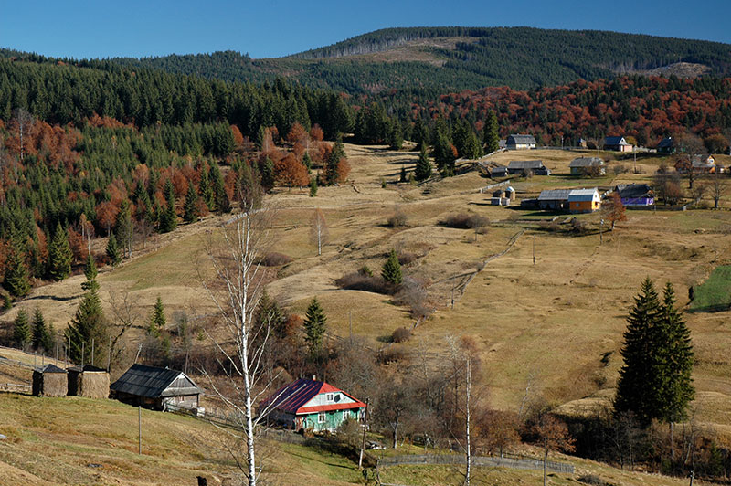
Shortly after turning south from the main road, we begin to climb and thankfully leave behind the fog and grey skies to emerge into radiant autumnal sunshine and gorgeous views of rolling hills, covered in primeval forests of green pines mixed with now-brown beech trees. On grassy hillsides between the stands of forest lie idyllic villages of colourful wooden houses, wicker fences and tall ricks of drying hay; a delightfully bucolic vista of pre-modern Europe. Our climb tops out at a little under one thousand metres at the Vyshkiv Pass, beyond which we descend into Transcarpathia, Ukraine’s most far-flung region.

Gorgany Mountains, Zakarpattia Region, Ukraine
The Outer Eastern Carpathians which we have just crossed have defined the border of the Hungarian Empire since the ninth century and Transcarpathia, or Carpathian Ruthenia, has since passed to the Habsburgs and Austria, then to Czechoslovakia between the World Wars, before incorporation into the USSR. Though Ukrainians today constitute a majority in Transcarpathia, there are sizeable minorities of Hungarians along the region’s southern border with Romania, and a number of Ukrainian ‘highlanders’; Hutsuls, Boykos and Lemkos, who are often collectively known as Rusyns, descendants of the Ruthenians.
In Mizhhirya we turn off the north-south road and climb east into the Gorgany Range and Synevyr National Park, one of the least populated areas of the Carpathians. We descend gently through very rustic villages such as Synevyr and Nehrovets, the latter of which has the fine early nineteenth century Archangel Michael Church built entirely out of wood in an architectural style characteristic of the region. We stop for the night in the large village of Kolochava, where we surprise the owners of a guesthouse by arriving so far out of season, and where we seem to be the only patrons.
The weather the following day is still perfectly clear, with crisp air and deep blue skies, and we set off early, following a stream north from the centre of the village, climbing up the curving spine of the Pyshkonya Ridge, first through dormant fields set with haystacks, then forests of spruce and beech, emerging high on the boulder-strewn ridge and spending several hours walking north, and then north-west on bare slopes of yellowing grass and occasional debris fields, reaching the 1707 metre high Nehrovets, the highest peak on the ridge. From here we have magnificent views of the rolling Carpathians which fall away into the distant haze in all directions on this beautiful day; a final glimpse of autumnal colour before the impending winter snows, and for myself a final indulgence in beautiful natural surroundings before returning to Western Europe.
It’s after dark by the time we descend from the ridge into the village of Nehrovets, and we’re grateful to hitch a lift for much of the ten kilometre walk back to the guesthouse in Kolochava, where we enjoy a good fireside meal. The following day we drive south down the Tereblya Valley, turning east at the end of the road and tracking the Tisza River which marks the Romanian border on a winding and at times quite scenic highway, looking south into the EU. Leaving the river valley, the road begins to climb, but the skies become dismal and grey once more and despite stopping for two nights in the small town of Kvasy, we decide against making any further walks in the mountains and leave the Carpathians without glimpsing Hoverla, Ukraine’s highest peak.
Market Square, Lviv, Lviv Region, Ukraine
Descending back to the edge of Ivano-Frankivsk, we head into Galicia, a region named after the medieval city of Halych which once was its capital. Galicia (initially united with more northerly Volhynia) was the westernmost of the states to emerge from the twelfth century collapse of Kievan Rus’ and subsequently passed to the Hungarians, Poles, Polish-Lithuanian Commonwealth, Habsburgs, Austria and, following heavy fighting in the First World War, was made part of the Second Polish Republic until the Soviet invasion of eastern Poland in 1939. Traditionally an agricultural and rather poor part of Europe, Galicia was populated mostly by Poles and Ukrainians, though like much of what was historically Poland was also a centre for European Jewry. During the twentieth century the borders and demographics of the region were brutally manipulated by vying powers, yet Galicia’s capital Lviv has somehow survived these ordeals physically unscathed and is Ukraine’s most attractive city; the cultural centre of the west of the country and a base of resurgent Ukrainian nationalism. We arrive after dark in the city, finding our way through the city’s winding old streets to our host Andriy, a native of Khust in Transcarpathia, who lives in an apartment in a nineteenth century town house rather than a typical Soviet housing block.
Latin Cathedral, Lviv, Lviv Region, Ukraine
Lviv was founded in the twelfth century by King Daniel of Galicia and Volhynia, and was named for his son Lev who, following the destruction wrought by the Mongols in the thirteenth century, rebuilt Lviv and transferred the capital here from Halych. Under the Polish-Lithuanian Commonwealth Lviv became a large urban centre, and despite numerous attacks by Swedes, Hungarians, Turks, Russians, Tatars and Cossacks (the latter of which were paid off to avoid capture of the city centre), the city prevailed. Under the Habsburgs and subsequent Austrian Empires, Lviv prospered and much of the city centre dates from this period, which latterly saw a flourishing of Polish, Ukrainian and Jewish culture until the Polish takeover in 1918, when Poles and Ukrainians engaged in a brief war.
The morning after our arrival, Karolina and I begin to explore Lviv, which immediately impresses me with its elegant, harmonious urban architecture. Unlike Odessa, Lviv appears to live up to its beguiling reputation and whilst Chernivtsi and Ivano-Frankivsk are rather sleepy provincial capitals, Lviv bustles with activity. While by no means overlooked by tourists, the city remains dignified and seems at present not to have submitted to the full force of mass tourism as one would find in similarly beautiful cities in Central Europe. Crossing Freedom Avenue, we lose ourselves in the streets and alleys of the old city which is centred upon the central Market Square. In the middle of this stands the Viennese Classical Ratusha or city hall, whose nineteenth century clock tower is open to visitors.
Old City, Lviv, Lviv Region, Ukraine
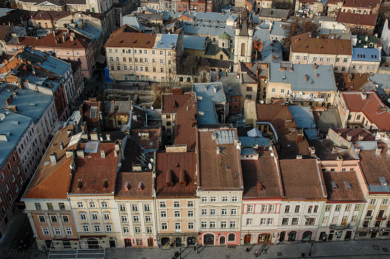
From the top of the sixty-five metre clock tower one has a spectacular view of the old city from its very heart, revealing grandiose Habsburg residences amid rows of three and four storey town houses in pale shades of peach, buff or pink and with sloping red terracotta or grey lead roofs, clustered somewhat haphazardly around small yards. For once, the Soviet urban planners have had the sensitivity to locate their comparatively graceless concrete buildings mostly in the suburbs, preserving the visual character of the city. What is perhaps most delightful are the roofs, belfries and clock towers of the various churches, cathedrals and monasteries which protrude above the roofs in all directions, giving Lviv the feel of a European Samarkand, or a miniature Jerusalem.
To the north is the distinctive white tambour and conical roof of the Armenian Cathedral, used by the Polish-Armenian community until their expulsion from Ukraine following the Soviet takeover in 1945. To the east lie several churches; the beautiful Baroque sandstone of the Dominican Church, now belonging to the Ukrainian Greek Catholic Church; the Dormition Church, the city’s largest Orthodox Church with its huge, square-plan Gothic Korniakt Tower; the Baroque facade of the seventeenth century Carmelite Church, sitting on an ancient mound a little beyond the centre; the distinctive Church of Poor Clares with its almost Art-Deco features and which is now a sculpture gallery, and the patinated green dome of the seventeenth century Bernadine Church and Monastery. Immediately to the south-west is the imposing Baroque of the fourteenth century Latin Cathedral belonging to the Roman Catholics, next to which is the unusual Boim Family Chapel, built in the seventeenth century by a Lviv merchant in the Italian Renaissance style, but with an unusual two-tiered carving of religious figures in blackened sandstone, rather reminiscent of an Indian temple. Due west of the square is the newly restored Jesuit Church, dating to the seventeenth century and once one of the largest churches of the Polish-Lithuanian Commonwealth, and finally to the north-west the Church of the Transfiguration, neatly slotted into a city street and also now also belonging to the Ukrainian Greek Orthodox Church.
Bernadine Church, Lviv, Lviv Region, Ukraine
After two days enjoying Lviv’s attractive streets, Karolina must return to Warsaw, and I start to look beyond Lviv’s centre and consider a rather less attractive side of the city’s history. The Polish takeover of Galicia in 1918 following the collapse of Austria-Hungary upset the balance of power in a region claimed by both Poles and Ukrainians, leading to the repression of the Ukrainian language and of Ukrainian institutions, and an increase in anti-Jewish sentiment. The Soviet occupation in 1939 saw the Poles lose their hegemonic position once again, and the move was highly unpopular in a region with no history of Russian influence, particularly given the fresh memory of Holodomor, the Soviet engineered famine which killed millions across Ukraine and southern Russia. It is perhaps not surprising then that when, as part of Operation Barbarossa, the Nazis and their Axis allies occupied Galicia in 1941, local Ukrainian nationalist militia were quick to ally themselves with the Nazis, hoping ultimately to gain an independent state, and happy to assist in the implementation of Nazi policies, taking revenge on Poles, Jews (blamed for collaborating with former Polish landlords and for Soviet mass-murders of local prisoners) and Bolsheviks. Many Jews who had recently fled the Nazis as they advanced east through Poland, into Soviet occupied Galicia now found themselves concentrated in the Lviv Ghetto.
I walk east, away from the city centre, passing Klepariv Station and walking down a wide ring-road through the city’s outer western suburbs, passing a rather grim looking modern prison compound on my right. Just beyond here lies a neglected patch of land with a lone monument consisting of a large boulder, inscribed in Ukrainian, Hebrew and English, commemorating the (up to) 200,000 Jews who perished here; for this is the site of the infamous Janowska concentration camp. As Operation Reinhard, the Nazi’s ‘final solution’ for Polish Jews was carried out, Lviv’s ghetto was dissolved, with those fit to work being incarcerated at Janowska, and those deemed unfit deported to via Klepariv Station to nearby Belzec death camp in what is now Poland. Apart from this modest rock memorial and a few bunches of plastic flowers, there is nothing to commemorate this spot, and indeed on a nearby whitewashed wall there is some crude graffiti consisting of a crossed-out Star of David and a Nazi Swastika, a worrying sign of contemporary local sentiment. Closer to the centre one finds a larger monument to the exterminated Jewish population, albeit in a small, fenced-off square next to a busy road, though it too is an occasional target for vandalism.
When the Soviets ‘liberated’ Galicia in 1945, the population was again ethnically cleansed, with over 100,000 Poles expelled to Poland and anyone whom the authorities had any suspicion of having collaborated with the Nazis shipped off to join the millions in Stalin’s Gulag system. Nevertheless, Lviv remained a major centre of the dissident movement throughout Soviet times, and today is, alongside Kyiv, the centre of the Ukrainian nationalist movement, playing a key role in modern Ukrainian politics.
Despite the grisly history, I leave Lviv after four full days of exploration with very positive impressions; perhaps a little surprised that what is just about the last city in the Former Soviet Union which I will visit on this four-and-a-half year journey, is also one of the very nicest.
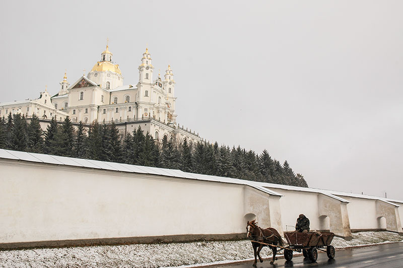
Pochayiv Lavra, Pochayiv, Ternopil Region, Ukraine
From Lviv I drive east on a good, recently surfaced road which leads eventually to the capital, and encounter my first real snow of the year; beautiful in the fresh white covering which it gives to the muddy autumnal landscape, but a harbinger of a long, cold winter I am keen to escape. I pass the ancient castle of Olesko, sitting on a small hill surrounded by a snow-dusted marsh of reeds and wild grasses. A little beyond I enter a corner of Ternopil Region, part of the medieval state of Volhynia which shares much the same history as Galicia up until its incorporation into the Russian Empire in 1795. I make a stop in the small town of Pochayiv, where the muddy fields and horsecarts of rural western Ukraine are overshadowed by the huge, walled lavra (Orthodox monastic complex).
Pochayiv Lavra was first mentioned in the sixteenth century, famed for its miracle-working icon. Despite an interregnum of Greek-Catholicism before Volhynia’s transfer to the Russian Empire, the lavra has long been a spiritual centre of Orthodox Christianity in the region, and since the nineteenth century has been the western outpost of Russian Orthodoxy, resisting Soviet religious persecution to remain functioning throughout the Soviet period, and now resisting takeover claims from the Ukrainian Orthodox Patriarchate and Ukrainian Greek Catholics. In contrast to Lviv’s strongly European influenced architecture, Pochayiv is immediately recognisable as Russian Orthodox with its gleaming golden domes and distinctive three-beamed crosses, and teems with pilgrims from across the Former USSR and the Balkans, though its impressive external appearance gives way to a rather ordinary interior.

Lubart’s Castle, Lutsk, Volyn Region, Ukraine
Continuing north from Pochayiv I’m taken by surprise in the nearby town of Kremenets when muddy, rural Ukraine again gives way to the beautiful, ornate Baroque Franciscan Abbey, overlooked by the remains of a medieval fortress on a craggy ridge. A little later, I make a brief stop to see Dubno’s riverside castle, then continue to my very final destination, the city of Lutsk, once capital of Volhynia. Though host to the beautiful fourteenth century Lubart’s Castle, built by a Lithuanian king, the town is otherwise rather ordinary. Damaged and heavily and depopulated by the events of the twentieth century, with its former Jewish population murdered by Nazis and Ukrainian nationalist extremists, and its Polish population either deported or expelled by the Soviets, Lutsk’s rather spread out and nondescript city streets gives one the impression that the city has never recovered. Lutsk’s Grand Synagogue, built in restrained, blocky Renaissance style has somehow managed to survive the Nazis and Soviets, a rather sorry reminder of a departed past with peeling plaster walls, now used as a sports club.
I leave Lutsk after dark, making the final journey via Kovel to the border crossing at Yahodin where, after waiting in long queues of Polish cars, I cross the Bug River in the early hours of the 18th November, entering the European Union and thus essentially ending the journey rather uneventfully, in the middle of the night, surrounded by small time traders and fuel smugglers.
I stay with Karolina for just over a week in Warsaw, after which we say a final goodbye and I continue west. I stop with family in Jena, just as I did on the outward leg of the journey, and spend a day in Brussels with Koen, a Dutchman I had met in Iran in early 2010, before catching the ferry from Dunkirk back to Dover. Here I am greeted back to the UK by wretched skies and torrential rain on the M20, but after getting slightly lost on narrow Kentish backroads, I arrive back where I started 1671 days and 155,681 kilometres earlier, at my childhood home in Hawkhurst, late in the morning of the 1st December 2011.
Stage 31 – Moldova & Transnistria: Bessarabia

Moldova occupies much of Bessarabia, a small chunk of Eastern Europe lying between the Prut and Dniester Rivers. It is a small country on the margins of the Former Soviet Union and the European Union, distinguishable from greater Romania (with which it has close cultural and linguistic ties) only by its history of Russian influence; obscure even to most Europeans and famed only as being Europe’s poorest country. As an area over which empires have long clashed, Moldova remains divided despite its modest size, incorporating a number of ethnic minorities and the de facto independent (though internationally unrecognised) state of Transnistria, where ethnic Slavs (Ukrainians and Russians) outnumber Moldovans. Having left neighbouring Romania with rather negative impressions in 2007 on the outward leg of the trip, I would be pleasantly surprised by Moldova; a friendly, calm and bucolic little corner of Europe which would be the final ‘new’ country on the initial four-and-a-half year part of the Odyssey.

Windmill, Beşalma, Gagauz Autonomous Region, Moldova
It’s early in the evening of the 17th October 2011, and I’ve just left the far south-east of Ukraine. Ahead of me is a one-kilometre stretch of Moldova and beyond that, across the Danube, is Romania and the EU. I however turn north in the port and border town of Giurgiuleşti and drive on quiet country roads passing small villages and long stretches of open agricultural land, soon entering the autonomous republic of Gagauzia. I stop for the night in the Gagauz capital of Comrat where I am hosted by Adam, a Fullbright Fellow from Indiana who is studying the Gagauz language.
Comrat is a quiet, though rather bland and impoverished provincial town, but through Adam I am introduced to a number of locals including Anna, an ebullient widow well into her sixties who is something of an adoptive mother to Adam, and who serves us endless quantities of good home-made wine in her cottage on the edge of town. I’m also introduced to a local TV cameraman who films a short piece on my journey by car through Moldova, which starts with me staggering around Anna’s garden looking at the grapes from which the wine I have been drinking is made, then cuts to me pulling out of town in the truck two days later. The piece went on to air on the national evening news.

Gagauz Man, Beşalma, Gagauz Autonomous Republic, Moldova
Adam and I take a minibus south out of Comrat to the village of Beşalma, which is Gagauzia’s cultural capital and home to the Museum of the Gagauz People. Beşalma is located in rolling, bucolic autumnal countryside planted with vineyards and maize, a scene which typifies rural Moldova. We walk from the main road past horsecarts and post-end-of-life European cars to reach the village, which has a few administrative buildings, the Soviet-era museum whose mosaic-work of Gagauz designs is slowly collapsing from its walls, and a beautiful six-bladed wooden windmill on a gentle rise overlooking the rambling village houses and surrounding fields.
We are shown around the village museum by a Gagauz lady who has a very Turkish face, with lumpen features, thick, masculine eyebrows and a heavy nose, and hands stained purple from recently pressing grapes. We’re directed to the history of the Gagauz people, who are Turkic Orthodox Christians. Although their origins are obscure, as is the origin of the term ‘Gagauz’, they are thought to be descendants of Bulgars, Cumans, Kipchak or Seljuk Turks who had migrated to the Balkans centuries ago. In the early nineteenth century the Gagauz migrated into Bessarabia from north-eastern Bulgaria in face of religious persecution from the Ottomans. Following the ceding of Bessarabia to the Russian Empire in 1812, the Orthodox Gagauz were encouraged to settle in place of expelled Muslim Tatars and Nogays. As a linguistic and ethnic minority, the Gagauz became somewhat Russified and highly assimilated into Soviet society, and resisted independence on the grounds of promotion of Moldovan (Romanian) as the only national language, and amid fears of Moldova joining Romania. Though initially calling for outright independence, following negotiations with the Moldovan parliament the Gagauz accepted autonomy within Moldova in an essentially peaceful process quietly lauded as a successful resolution to ethnic conflict.

Old Orhei, Moldova
I leave Adam and Gagauzia after three very pleasant days and head north towards the centre of Moldova, through gently rolling hills, vineyards and muddy, geese-filled villages on quiet, tree-lined roads. I’ve immediately come to like Moldova which, without the hordes of tourists of Crimea or Odessa feels like a slice of pre-modern Europe, similar to Romania but without the pervading air of seediness. Moldova is certainly not a country full of sights of interest, but after stopping for a night in Chișinău I continue north, getting lost on rough country roads but eventually being steered by friendly locals to the village of Trebujeni and the archaeological site of Old Orhei, which might possibly pass as Moldova’s prime tourist attraction. Old Orhei is set within the gentle sweep of a time-smoothed limestone escarpment above a deeply incised meander of the Răut River, not far from its confluence with the Dniester. In this naturally defensible location, meagre remains can be found from throughout Moldova’s history; from the Palaeolithic, through to the Dacians, Mongols and on to the modern period.

Stone Cross, Old Orhei, Moldova
Old Orhei is an enchanting place and I walk up onto the escarpment to find a very picturesquely sited orthodox church and just beyond, an almost pagan looking carved stone cross against which a rather grief-stricken woman is leaning for strength. It’s a mild late-October day, surely one of the last mild days of the year and the long, reddish sunlight has an air of benign finality, casting the surrounding landscape in pastel shades of yellow and brown. Below me in the sweep of fields enclosed by the escarpment, peasants busy themselves gathering in maize, transporting the remaining stalks on trotting horse-carts to be stacked in conical ricks in the village. In the rock below me, very well hidden, is a cave monastery dug out by orthodox monks in the thirteenth century, though I find the door closed and so scramble down the steep bank for a view. Here, in the rock face are a number of glazed windows and a door, out of which a slightly grizzled-looking elderly priest emerges, who rinses his hands and then asks me in English where I am from. Clambering back up a narrow trail, I find the door now unlocked, and descend through the rock into the Stygian chambers of the monastery. The priest leads me around, pointing out eleven rock-hewn sleeping cells for the monks who had previously used the monastery until the eighteenth century, after which the monastery had fallen out of use until restoration work commenced in 1996.

Eternity Monument, Chișinău, Moldova
Savouring this Moldovan experience, I return to Chișinău, the national capital. Chișinău, known as Kishinev to Russian speakers, was transformed from a small town to provincial capital upon the ceding of Bessarabia to Tsarist Russia in 1812, which set the stage for the emergence of an independent country. Moldova’s statehood may be traced yet further back in time; to the fourteenth century when the principality of Moldavia was established, incorporating Bessarabia and areas of what is now eastern Romania, and whose leader from the mid-fifteenth to early sixteenth century, Stephen The Great, is now the national hero of independent Moldova. Despite putting up an initially successful resistance, Moldavia eventually became an Ottoman tributary in the mid sixteenth century, until incorporation into the Russian Empire in 1812 as part of Russia’s gains against the Ottomans. Following the Russian revolution of 1917, Bessarabia returned to Romanian control, was then ceded back the Soviet Union in 1940 as part of the secret terms of the Molotov-Ribbentrop Pact, only to be re-occupied by Romania in 1941, finally returning to Soviet control at the end of the war.

Nativity Cathedral, Chișinău, Moldova
Chișinău gleams like a vision of the future as one approaches it from the timeless, rolling Moldovan farmland. As one enters the city however, the quaint rural squalor of muddy streets and tumbledown cottages gives way to a rather less attractive urban squalor; of broken asphalt, ageing apartment buildings, reckless traffic, alcoholics, poverty and screaming inequality. But these shabby suburbs conceal a far more upbeat centre which I soon find myself warming to.
I spend two days exploring Chișinău, walking from my host Artur’s apartment to the Eternity Memorial, a pyramid made up from five red, stylised rifles in remembrance of the years 1941 to 1945, built by the Soviets and pointedly neglecting the early war years when Moldova’s fate was secretly decided between the Soviets and Nazis. Adjacent to the memorial is a beautiful, leafy cemetery, entered through a crumbling Neoclassical arch and containing an intriguing cross-section of Chișinău’s former residents. Numerous Jewish graves are scant evidence that Chișinău was at the beginning of the twentieth century one of the major centres of European Jewry, though through pogroms, the Holocaust and emigration from the USSR the community has almost vanished today. Subtle reminders of their presence persist however in a distinctly Moorish appearance to some of the windows and doorways of the city’s more elegant central streets.
Chișinău’s main focus is Stephen the Great Boulevard, along which one finds Cathedral Square with the Triumphal Arch built in 1840 to commemorate the Russian victory over the Ottomans, and behind this the Nativity Cathedral, centre of the Moldovan Orthodox Church. Opposite is the huge, Soviet Government Building and statue of Stephen the Great, bearing a cross as ‘True Champion of the Christian Faith’ for his victory against the Ottomans, an image featured on every Moldovan banknote. A number of grandiose building projects can be found further along the boulevard, which do a good job of giving Chișinău the air of a national capital, though on close inspection some of these appear to be unfinished; long-stalled construction projects with falling, tattered veils and peeling siding.

Chișinău, Moldova
As capital of the Bessarabian Region of the Russian Empire, Chișinău experienced rapid population growth in the nineteenth century and despite heavy destruction in the Second World War, retains an elegant centre with avenues lined by plane, poplar and walnut trees, to which I find myself often returning to stroll in. Away from here much of the city bears the architectural hallmark of the rapid post-war Soviet expansion, such as the towering fourteen-storey apartment complexes which flank Dacia Boulevard in the south-east of the city and are known locally as the ‘City Gates’. Other relics of the Soviet era have poignantly gone to seed, such as the abandoned circus with its grimy windows and broken front steps. Nowhere however do I feel any real sense of iniquity and despite the obvious poverty and inequality, the atmosphere of the city is friendly, relaxed and fun. Chișinău has more grace than most Soviet cities, with a hint of European flair, though has far fewer pretensions than most Eastern European cities. I could almost imagine myself living here.
I leave Chișinău on a beautiful autumn day passing through the ‘City Gates’ on a wide, divided road heading south-east towards the Dniester. My destination is Tiraspol, officially Moldova’s second largest city though in reality the capital of the wholly unrecognised state of Transnistria, which has its own government, police, army, customs, postal service and even currency, despite being a tiny sliver of land lying mostly between the left bank of the Dniester and the nearby Ukrainian border. I pass an outer checkpoint just beyond the Moldovan city of Anenii Noi, then shortly after arrive at the Transnistrian Border. My initial impression, as I am asked to fill in a migration card, is of how unusually polite and professional the immigration staff are. Next, a female customs officer who speaks perfect English asks for my vehicle registration document and begins to enter details into a computer system to calculate an entry tax. Frighteningly large numbers are displayed, but I finally pay just fourteen US Dollars, valid for two months, and after a cursory inspection of the truck I am free to enter Transnistria. I soon stop on the edge of the city of Bender which, though lying on the right bank of the Dniester and officially a buffer-zone, is in reality Transnistria’s second largest city.

Bender Fortress, Bender, Transnistria
Bender’s one and only sight is a striking fortress which marks the city’s historical position as a customs post between Moldavia and the Crimean Tatars. The fortress lies on the edge of a large base of the Transnistrian military and has only very recently been opened to foreigners. To reach it I must double back from the bridge across the Dniester, then find an unmarked side road leading to a trolleybus factory which is emblazoned with large and well preserved Soviet murals of a worker and a map of the Soviet Union. From here I must walk along a muddy, overgrown path escorted by a guard, past large, neglected factories lined by fir trees and dank, abandoned barracks whose roofs support mature poplar trees. After several minutes I reach the fortress, in front of which are busts of heroes from the Russo-Turkish wars, with fine views east across the Dniester. Initially a Moldavian fort made from wood, the current structure, which is undergoing restoration, dates from the sixteenth century and its construction under the Ottomans is said to have been overseen by Mimar Sinan, the architect responsible for many of İstanbul’s most beautiful buildings. The outer walls of the fortress have largely disappeared, but its inner keep, despite the rather clumsy restoration work remains very striking, with thick, high crenelated stone walls and towers of round, square and octagonal section topped by fluted terracotta-tiled roofs.
House of Soviets, Tiraspol, Transnistria
Back in the truck, I re-navigate the overcomplicated Soviet traffic system on the outskirts of Bender and cross the bridge into Transnistria proper, where I am very soon in the capital, Tiraspol. That Transnistria exists as a de jure part of Moldova, rather than Ukraine (which would seem more logical when looking at national boundaries) is due the the creation of the Moldavian Autonomous Soviet Socialist Republic (ASSR) in the early twentieth century, which was carved out of the Ukrainian ASSR with a view to the Soviet Union re-acquiring Bessarabia. Thus, when the Soviets finally regained Bessarabia in 1940 and created the Moldavian Soviet Socialist Republic (SSR), the precursor of modern Moldova, it included the thin sliver of land along the left bank of the Dniester known as Transnistria.
During the final years of the USSR, as Gorbachev’s policy of glasnost set the course for greater autonomy of the Soviet Union’s constituent republics, Moldovan became the only official language of the Moldavian SSR in a move highly unpopular with the republic’s Slavic and Turkic minorities. With independence looming, the expectation for the Moldavian SSR to re-join Romania was widespread and highly unpopular with non-Moldovans. Much like the Gagauz in the south, Transnistria’s Slavic majority claimed independence, but whereas the Gagauz conflict was resolved peacefully, tensions between Transnistria and Moldova escalated to violence in 1990 and into full-blown civil war for five months of 1992, which ended in a cease fire and Transnistria’s status as a de facto independent state.

Victory Park, Tiraspol, Transnistria
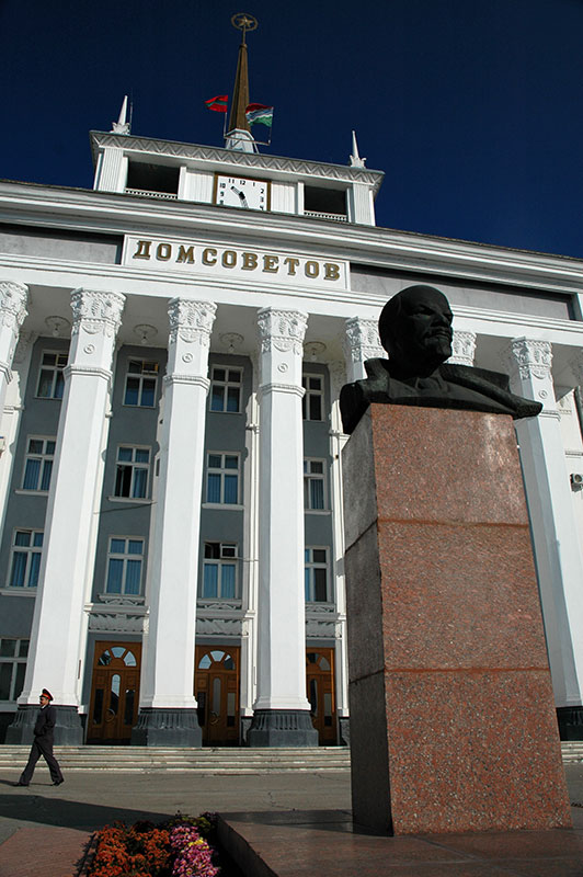
Tiraspol’s name derives from ancient Tyras, the Greek name for the Dniester River and also the name of a long-gone nearby settlement. The city’s history officially begins with its establishment in 1792 by Alexander Suvorov, the last Generalissimo of the Russian Empire, famous for his victories against the Ottomans, and for having never lost a battle. My first impressions of Tiraspol are of manicured Soviet order, with meticulously maintained Soviet-era administrative buildings, monuments and nomenclature in Cyrillic script. Outside the large red and grey parliament building is a pink granite statue of Lenin with a billowing cape, and across the street a Soviet T34 tank from the Second World War. Next is an equestrian statue of Suvorov who, despite being born in Moscow, is the Transnistrian national hero and features on all Transnistrian Rouble banknotes. A little further along 25th October Avenue, Tiraspol’s main drag, comes the House of Soviets; an imposing masterpiece of Soviet architecture, outside of which is another bust of Lenin on a pedestal. At the end of this rather grandiose strip the road turns past the entrance to Victory Park, which is now in riotous autumnal colour, then soon enters the semi-rural suburbs which surround Tiraspol on all sides.
My host in Transnistria is Vova, who is of mixed Ukrainian and Russian heritage, and who works for the Transnistrian Ministry of Foreign Affairs in Tiraspol, but lives with his grandparents in the nearby village of Karagash where I arrive in the evening before Vova gets home. Here I am met by Igor, Vova’s jolly grandfather who welcomes me into his garden, showing me his beloved doe goat, his pigs, chickens and other goats, their cat Terry and their smart Belgian shepherd who doubles as a doorbell. Inside, the house is extremely comfortable and my lasting memory of Transnistria is of long evenings at the dinner table eating Vova’s grandmother’s home-cooked food, drinking young home-made red wine and eating home-grown walnuts.

Dniester River Bend, near Grigoriopol, Transnistria
I make a short trip out of Tiraspol, taking a footbridge over the Dniester and then a minibus which drops me outside another Lenin bust in the large village of Kitskany, one of the oldest villages in the region. Here I visit the Holy Ascension monastery with its candy-cane red and white door and window pillars, then walk up out of the village to an obelisk commemorating the Jassy-Kishinev Offensive, whereby the Red Army recaptured the Moldavian SSR from the Axis Forces in 1944. It’s a beautifully serene spot overlooking the sloping farmland above the Dniester. Transnistria seems quite unlike the other frozen conflict zones of the Former USSR which I have visited; there is no obvious hatred or even animosity, no tensely sealed border or fanatical national rhetoric. Instead, I find a welcoming, safe and peaceful country with a gentle atmosphere of removal from the rigours of the outside world. From Kitskany I catch another minibus on to the centre of Bender, where bullet holes from the civil war are still visible in some buildings. After stopping in a bar for a bottle of local beer one of the cheapest I have ever drunk, I take the trolleybus back across the Dniester and into Tiraspol.
Dniester River, Ţipova, Moldova
After saying farewell to Vova and his lovely grandparents, I spend my last day in Transnistria driving through much of the country, following the Dniester upstream through the villages and towns along the left bank of the river, which separates Transnistria from Moldova proper in long, sinuous meanders. I stop in Dubossary, where the Civil War broke out, then later in Ribnitsa, Transnistria’s third largest city where in the late afternoon I re-cross the Dniester, with a final view of the city’s apartments reflected in the blue water of the river.
On the far side of the river is the town of Rezina, situated on three terraces overlooking the river, where I stop for the night. In the morning I take a minibus south to the village of Saharna where the Holy Trinity monastery nestles in the limestone escarpment alongside the Dniester. Behind the monastery I walk up into the hills, past cave cells and a cold, spring-fed baptismal pool, up into the hills where locals claim there is a footprint of the Virgin Mary in the native rock. It’s a beautiful autumnal walk through yellowing oak forest under deep blue skies, with sweeping views back across into Transnistria, and I spend more than an hour dozing in the sun.
Soroca Fortress, Soroca, Moldova
I leave Rezina the following day, driving initially south to the cave monastery in Ţipova. Like Old Orhei the monastery here is hewn out of limestone cliffs, this time in a slightly less dramatic location overlooking the Dniester, but it is said to be older, dating from the tenth to twelfth centuries, and also to be the place where Stephen the Great was married. Turning north from Ţipova I head for the Ukrainian border, passing more bucolic villages on the way to Soroca, which overlooks a historical crossing point on the Dniester. Soroca has another beautiful fortress smaller but more unusual than that of Bender. Built initially out of wood by Stephen the Great in 1499, it was rebuilt in the following century to be a perfect circle with five equally spaced towers, forming a part of the line of defences along the Dniester from Akkerman (Bilhorod-Dnistrovskyi, in Ukrainian Bessarabia), through Bender, and continuing north, up into what is now western Ukraine.
I leave Moldova on a cool, foggy morning, driving the final stretch from Soroca north-west, parallel to the Dniester, to the border town of Otaci where I cross the bridge into Ukraine. Moldova has been a pleasantly surprising country; clearly very different from neighbouring Ukraine with its strong Romanian influence, friendly, welcoming and wonderfully tranquil, despite the obvious poverty and the frozen conflict with Transnistria. Ahead of me lies the very final stage of my initial four-and-a-half year trip, through the medieval cities and Carpathian Mountains of western Ukraine, before I must make my rather dreaded return to Western Europe.
Stage 30 – Russia & Ukraine: Chernozem, Donbass And Crimea [2/2]

I drive across the Dnieper River on 10th September 2011 and enter Kyiv, the Ukrainian capital where I am hosted by Mykola, a paramedic who lives with his mother in the extreme north of the city. Back in June 2007, a night spent in Kyiv on my way east at the very beginning of the Odyssey had been my first encounter with the Former USSR and the Russian-speaking world, and I imagine what it would be like to bump into myself, now at the end of my trip, four years, four months and four days later, having become so familiar with the former Soviet world.

Podil, Kyiv, Ukraine
Kyiv grew up as a city on the trade route between Scandinavia and Constantinople and was part of the Khazar Khanate, a semi-nomadic Turkic civilisation which controlled much of the western Silk Road in the Volga – Don region during the seventh to tenth centuries. The city was then seized by the Varangians and became capital of Kievan Rus’ in the ninth or tenth centuries, the progenitor of modern-day Russia, Ukraine and Belarus which would give rise to the first Rurikid Dynasty of Russian Tsars. Kyiv would have been one of the world’s largest cities prior to the Mongol invasion of 1240, when it was completely destroyed and would remain relatively obscure throughout the following period of incorporation into the Polish-Lithuanian Commonwealth and Russian Empire, only regaining prominence during the nineteenth century industrialisation of Imperial Russia. Kyiv was the third largest city of the Soviet Union and became the capital of Ukraine following independence in 1991, and plays an important role as the cultural capital of the pro-European Ukrainian identity whose proponents are very keen to distance themselves from the Russian-dominated past.

St Michael’s Golden Domed Monastery, Kyiv, Ukraine
Kyiv is an immediately likeable place, attractively sited next to the deep blue Dnieper River on a number of hills, with a centre of wide streets of often elegant city blocks, squares and parks. It’s a far nicer city than Moscow for example, with a more upbeat and laid back atmosphere, though it is visibly more European and rather less exotic, with crowds of tourists and English frequently heard on the street. I start a walk around the city from the very centre, in Independence Square where a tall column topped by a statue of Berehynia, a female spirit from Slavic folklore which has recently been adopted as a symbol of the Ukrainian independence movement has replaced Lenin on his plinth. North-east of the square I pass through the Soviet-era Friendship of Nations Arch and enter the long city park which is spread along the right bank of the Dnieper with beautiful views across to the left bank and the city’s smaller eastern segment. Here the city’s bright high-rise suburbs look almost like an island, surrounded by an uninterrupted sea of green, arboreal endlessness spreading to the horizon. Looking east across such a wide open space causes me to pause for a moment and imagine the wild expanses of steppe which stretch off for thousands of kilometres to the east, a magnificent landscape I will surely miss on my return to western Europe. Back in the centre, to the north and above Independence Square is the beautiful St Michael’s Golden Domed Monastery, originally built in the eleventh century, but totally destroyed by the Soviets in 1935, having only recently been rebuilt. Facing the monastery down a wide street several hundred metres in length is the slightly older, though less visually arresting Saint Sophia’s Cathedral, with both structures being considered masterpieces of Ukrainian Baroque. Outside Saint Sophia’s this showcase of Ukrainian independence is completed with a large statue of Bohdan Khmelnytsky, the hetman (head of state) of the Zaporizhian Cossack Host who led an uprising against the rule of the Polish-Lithuanian Commonwealth in the seventeenth century and effectively established an independent Cossack State, a mooted progenitor of an independent Ukraine.

Dnieper River, Kyiv, Ukraine
I leave Kyiv and Ukraine to spend just over two weeks with Karolina in Warsaw, during which time I decide upon a subject to study for a master’s degree upon returning to the UK at the end of the year; a decision which would come to dictate my future career. When I return to Kyiv in late September, I find that late summer has transitioned into autumn, with warmth and deep blue skies replaced by cool, damp weather and glorious autumnal colours. I return to the Dnieper’s right bank, to the Kyiv Pechersk Lavra, an eleventh century cave monastery which has become one of the most important centres of Eastern Orthodoxy, chief monastery of the Ukrainian Orthodox Church and residence of its metropolitan. Beyond the lavra lies a sculpted Soviet-era park celebrating victory in the Second World War with monolithic, brutalist concrete architecture, bronze dioramas of valiant Red Army soldiers and the sixty-two metre high Motherland Monument; a mother of Ukraine holding up a shield with the Soviet coat of arms and a sword, later truncated so as not to stand higher than the highest cross of the nearby lavra.

Andriyivskyy Descent, Kyiv, Ukraine
From the park I return to the city centre, past the lavra and on to the memorial and museum dedicated to the Holodomor, the Ukrainian term for the Soviet famine of 1932-33 which killed perhaps six to eight million people in what is today Ukraine, Russia, Belarus and Kazakhstan, of which four to five million are thought to have been Ukrainian. Holodomor, literally meaning ‘extermination by hunger’ has become a contentious international (and domestic) issue, raising the issue of whether the famine was a deliberate attempt to wipe out the Ukrainian people. The museum contains graphic images of the sufferings of Soviet Ukrainians during the famine years, but what lingers in my mind most is the pointedly anti Russian sentiment, with the famine being blamed roundly on Russians, rather than Soviets, and the whole museum has more than a touch of fanatical nationalism. Continuing through the park, I end up in the riverside district of Podil, one of Kyiv’s oldest, which I also recognise to be the neighbourhood in which I spent a night in a hostel in 2007 after blindly navigating my way across the city. From Podil’s slightly gritty, riverside charm I walk past a number of churches which have survived the Soviet period, climbing finally along Andriyivskyy Descent, lined by stalls selling tat to tourists, past the striking though gaudy Baroque of St Andrew’s Church, down Volodymyr Street to the Golden Gates, the completely restored (largely from imagination) main gate of the eleventh century fortifications of Kievan Rus’, where I get onto the Metro back to Mykola’s apartment.
Petrovskogo Square, Dnipropetrovsk, Dnipropetrovsk Region, Ukraine
I leave Kyiv having experienced the assertive character of the modern though deeply-rooted Ukrainian identity, something I had barely encountered in the east of the country. I make my way south-east on a cool Sunday morning, following the corridor of the Dnieper River which bisects the country, passing through the pleasant, tree lined centre of Cherkasy, crossing the river in Kremenchuk and cutting slightly inland, through rolling farmland which seems to be bracing itself for the impending winter. This region south of Kyiv, on the left bank of the Dnieper was historically known as the ‘Wild Fields’, and was an area depopulated by raiding semi-nomadic Nogays, and a warpath across which Imperial Moscow and the Crimean Tatars would invade each other’s territory. Cossacks first tamed the tribes in this area, but it was Catherine the Great who incorporated it into the Russian Empire in 1764, renaming the area ‘Novorossiya’, literally ‘New Russia’. I stop for the night in Dnipropetrovsk, Ukraine’s third largest city originally named Yekaterinoslav and proclaimed capital of Novorossiya. A closed city during Soviet times, Dnipropetrovsk was famous for its nuclear, arms and space factories, collectively known as Yuzhmash and ostensibly manufacturing tractors and kitchen appliances.
Dnipropetrovsk remains a thoroughly industrial city, a commercial and political powerhouse, rather more down-to-earth though far less charming than the capital. The city centre is a mix of grandiose early Soviet blocks, wide avenues, squares, and shining new glass-fronted skyscrapers, and it is only at the regional museum, whose courtyard is filled with balbals (kurgan stele) from the surrounding countryside, that I am reminded that this region was until relatively recently, culturally far closer to the steppes of Central Asia than of settled Europe.

Kurgan Stele, Zaporizhia, Zaporizhia Region, Ukraine
I leave the city heading due south on a busy, divided highway which parallels the Dnieper, making the short journey to the city of Zaporizhia after dark. Like Dnipropetrovsk, Zaporizhia is a largely industrial city, though without the same air of dynamism and prosperity. Zaporizhia grew up as a modern Soviet city around the Dnieper Hydroelectric Station, built with the assistance of American engineers during the period of heavy Soviet industrialisation in the 1920s and 30s, though it has a far more prominent role in Ukrainian history as the base of the Zaporizhian Host, or Cossack Hetmanate (state) founded by Cossack hetman Bohdan Khmelnytsky. The origins of the Cossacks are thought to lie in Slavic serfs and criminals escaping feudalism and incarceration during the times of the Polish-Lithuanian Commonwealth, mixed together to some extent with native Turkic groups such as the Cumans. Once allied with the Tsardom of Russia, the Cossacks would help to drive Polish-Lithuanian elements from the region of the left bank of the Dnieper in the seventeenth century. Later, under Catherine the Great, the Cossack state would be ruthlessly disbanded, with Zaporizhian Cossacks fleeing to the Danube and Russia’s Kuban Region. The Zaporizhian Cossacks traditionally lived on the riverine island of Khortytsia, close to the rapids on the Dnieper (now submerged by the dam) and which today separates the eastern and western halves of modern Zaporizhia. Here one finds their beautifully reconstructed sich (military encampment), though the island’s kurgans (burial mounds) and stele hint at a history which extends into the Cuman or perhaps even Scythian period, pre-dating even the Cossacks.

Khortytsia Sich, Zaporizhia, Zaporizhia Region, Ukraine
In Zaporizhia’s spread-out and rather down-at-heel centre, I take a walk along the shore of the reservoir which the Dnieper has become, looking out on this mild but grey day across to the cranes and docks of the far bank. It is here that I encounter Nikolay, a bright-eyed old street sweeper with a few days’ of stubble and a battered hat, who immediately engages me in conversation; stating that former prime minister Yulia Timushenko is a bandit, along with a number of her cronies, though he is most visceral about Russian-Jewish oligarch Boris Berezovsky, whom he maintains was the mastermind of the September 11th attacks on the United States. Nikolay claims he was a general in the Soviet Army, and tells me of fast breeding nuclear reactors and prototype laptops during Soviet times. Finally, he asks me: ‘You know how the Soviet Union collapsed?’ ‘No’ I say, lacking the Russian to explain my understanding of the root causes of the matter. ‘It was me! There was a Lenin Statue there’ he says, pointing across to the port. ‘I was there. I went to a small cafe in 1987 and bought an ice cream and lemonade with five roubles. Then I got in my tractor, gunned the accelerator and smashed the statue.’ ‘And what happened then?’ I ask, unable to contain my laughter, though Nikolay is also laughing at his animated story. ‘The KGB came, but when they saw who I was, they got a fright, and that was the end of that. They picked it up and threw it away!’ At no point in our conversation does the fact that he is a shabby street sweeper smoking the cheapest papyrosa (unfiltered cigarettes) reduce his credibility, and he’s obviously an intelligent person, which makes me wonder, upon pulling myself away from his wild stories, if there might be an element of truth to them.

Yeni Kale, Kerch, Crimean Autonomous Republic, Ukraine
Beyond Zaporizhia I soon leave the Dnieper and head due south through Melitopol towards the coast of the Azov Sea, where in a scrubby area of sand-spits and salt marshes I cross onto the Crimean Peninsula, an autonomous republic within Ukraine. Historically poised between the classical world and the civilisations of the steppe which spread almost endlessly to the east, Crimea has long been a nexus of various empires and has an exceptionally rich and varied history. Greeks, Persians, Romans, Byzantines, Genoese, Venetians and Ottomans have all settled the Crimean peninsula, in addition to numerous semi-nomadic empires from the surrounding steppe, most notably the Crimean Tatars who founded an independent Crimean Khanate following the Mongol withdrawal, and ruled until the Russian takeover in 1783. Most recently, in 1954, Khrushchev transferred the majority Russian Crimean Peninsula to the Ukrainian SSR for reasons which are not entirely clear, and perhaps even controversial.
The atmosphere of Crimea is noticeably different from that of the rest of Ukraine. It’s not because of the landscape; the rolling, barren grasslands in the north which evoke Kazakhstan or Mongolia. Nor is it the forlorn or even half-derelict villages of the interior which sit largely quiescent, like small, forgotten kolkhozes (collective farms) out on the torrid steppe of Central Asia. It’s also not the glut of tourists and seedy amenities provided for them, which makes it about the most obviously touristy part of the Former USSR I have yet seen. What really makes a noticeable impression are the faces of the people; hard, weather-beaten faces with a melting pot of features from pure Slavic to Asiatic, and a slightly coarser, less European street attitude which makes Crimea feel far more like Russia than Ukraine. Small observations such as Ukrainian road signs which have been changed to Russian spellings by peeling off a letter or alteration with spray paint hint at an underlying tension and resentment of Ukrainian nationalism from some of the Russian population.

Docks, Kerch, Crimean Autonomous Republic, Ukraine
My first stop in Crimea is the city of Kerch, a slightly shabby but charming port city overlooking the Kerch Strait, which separates Crimea from the westernmost point of Russia’s Black Sea coast. I’m hosted here by Vlad, a tallyman for a French shipping company, who shows me his city and its surroundings. Kerch is one of Crimea’s oldest cities and was founded twenty-six hundred years ago as Panticapaeum, a Greek colony whose sparse fragments of toppled limestone pillars and temple floors dot Mount Mithridates in the centre of town. From this ancient hill one can look across Kerch, to a view damaged by war and neglect, over the attractive, pure Byzantine eighth century church of St John the Baptist towards the still busy docks. In the vicinity of Kerch Vlad shows me a string of noteworthy sights, starting with the huge ‘Royal Tomb’, a well preserved kurgan (tumulus) thought to date to the fourth century BCE during the time of the Bosporan Kingdom, a Roman client state. One enters the kurgan along an impressive, steep limestone dromos which, rather like a huge birth canal, leads to the magnificently vaulted, though empty central chamber. Further to the north east we take Vlad’s Zhiguli off-road across the steppe to reach a group of mud volcanoes which gently spew cold mud to the surface in a barren moonscape of dessicated mud, then return to the coast to finish our tour at Yeni Kale, a neglected Ottoman castle built overlooking the Kerch Strait in the early eighteenth century during the time of the Crimean Khanate. For early October the weather is beautifully warm and sunny, with views across to Port Kavkaz in Russia, and I start to see why Crimea was one of the prime holiday destinations of people from across the USSR and Eastern Bloc.

Genoese Fortress, Sudak, Crimean Autonomous Republic, Ukraine
Vlad is half-Russian, half-Ukrainian, though clearly identifies Russia as his homeland. He’s sceptical of Ukrainian nationalism, something he very clearly wants to distance himself from, and views Ukraine as something of an artificial country. ‘Those people in the west are totally different from us, we can’t live with them.’ ‘So what is the solution?’ I ask. ‘We should be apart, two separate countries. They will have their capital in Kyiv, which is a den of nationalists, and ours will be in Kharkov’ (not Kharkiv, the Ukrainian appellation).
I’m beginning to see the extent to which Ukraine is divided regionally and question the identity of the country as a whole, with Vlad’s word’s in my mind as I head west across the steppe, entering more fertile territory beyond Feodosia where vineyards run up the mountain slopes. I stop in the small town of Staryi Krym, once perhaps capital of the Crimean Khanate and with a fine, beautifully carved though partially ruined Ottoman-style mosque which looks to be straight out of rural Anatolia. Heading south, I cross the rugged limestone peaks of the Crimean Mountains whose slopes are ablaze with magnificent autumnal colours, dropping down to the famed Crimean Riviera and the attractive resort town of Sudak, where I am hosted by Rimma, a Russian-Jewish woman originally from Vorkuta in the frigid polar north of European Russia.

Black Sea Coastline, Novyi Svit, Crimean Autonomous Republic, Ukraine
Sudak is understandably a popular tourist resort and buzzes with holidaymakers from across Ukraine and Russia. The town shares in Crimea’s long history of successive empires, but was famed as a staging post and trade centre of the Silk Road in the thirteenth and fourteenth centuries, giving it a tantalising link to the desert cities of Central Asia from which I have recently arrived. Without doubt, the town’s main attraction is its magnificent Genoese fortress with walls and towers of serried battlements draped over the dramatic, grassy limestone cliffs, evocative almost of the Great Wall of China at the farthest end of the ancient Silk Road. The fortress overlooks a beautiful bay, but it is a few kilometres to the west, in the village of Novyi Svit (literally ‘New World’) that one sees some of Crimea’s most magnificent scenery. Novyi Svit is a beauty spot famed throughout the Former USSR both for its views and for sparkling wine, and is a little more upmarket than many of Crimea’s resorts. There are still hordes of tourists around, though I manage to steal myself away from the trail across the coastal cliffs, scrambling down to the shade of an emerald-green Austrian pine for a blissful hour or so, looking across the azure waters of the Black Sea to towering outcrops of jagged limestone. I walk back all the way to Sudak, enjoying the last warm evening of the season whilst passing vertiginous limestone cliffs popular with climbers where ornate, straggling pines cling to the sheer slopes like pieces of Chinese miniature art.

Swallow’s Nest, Haspra, Crimean Autonomous Republic, Ukraine
Heading west, the road winds up into the hills, dropping down occasionally past vineyards and through the coastal town of Alushta, climbing once again before dropping slowly down into Yalta, which I immediately dislike for its downmarket resort atmosphere. On the city’s southern edge I pull in to visit the Livadia Palace, the summer retreat of the last Russian Tsar where Churchill, Roosevelt and Stalin shaped the post-war world, but the tourist hordes and parking mafia cause me to flee. I stop briefly in Haspra, a nondescript coastal settlement famous only for the ‘Swallow’s Nest’, the iconic pleasure castle of Baron von Steingel, a rather underwhelming Neo-gothic folly which nevertheless draws crowds. Indeed, so far I’m rather disappointed, though hardly surprised at the volume of tourism here, even in mid-October, and so continue directly on the city of Sevastopol. My vision of Sevastopol as I enter the city’s eastern suburbs is one of neglect and decay; of broken, litter-filled streets through slum neighbourhoods where children and adults busy themselves in the litter bins.

Chersonesus, Sevastopol, Ukraine
Despite all the romance attached to the city’s name, Sevastopol is in fact a relatively young place, founded in 1783 by a Scot in the service of Russia. The bay around which the city is focussed has however long been a strategically important port and it is here, on the coast to the west of the modern centre, that one finds Chersonesus, the most impressive Greek ruins in the Former USSR. Founded in the sixth century BCE by the ancient Greeks, Chersonesus passed to the Romans, Huns and then Byzantines who used the far-flung port as a place to monitor the barbarian tribes who lived beyond, and as a place of exile for deposed popes and emperors. Its most important moment in history came in the 980s when the city was absorbed in Kievan Rus’ and is where, legend has it, Vladimir the Great, the Varangian prince of Novgorod who conquered a huge swathe of land from the Baltic to what is now Ukraine, was ordained into Christianity, thereby largely ending the pagan era of Kievan Rus’ and sewing the roots of the modern Eastern Slavic Orthodox Church. The spot where this supposedly happened is commemorated with a modern church, but the ruins of ancient Chersonesus are far more attractive, presenting a view which is pure Greek; of low remains of buildings and walls and tall, lonely Corinthian columns of white limestone set against an azure sea.

Balaklava Harbour, Sevastopol, Ukraine
On the southern side of the peninsula, just beyond the outer suburbs of Sevastopol lies the small town of Balaklava, infamous for the ‘Charge of the Light Brigade’ which took place in the valleys immediately to the north; a botched cavalry charged which saw huge losses for the British during the Crimean War of 1853-56, when France, Britain, the Ottomans and Sardinia fought to stop Russian expansion into lands of the weakening Ottoman Empire. Balaklava is centred around a beautiful harbour, far more refined than anything in Sevastopol proper and with a distinctly Mediterranean atmosphere. Small, quiet, streets wind past the whitewashed buildings of the harbour which is packed with colourful wooden fishing boats and beyond, millions of dollars worth of yachts and cabin-cruisers belonging to the rich, though the atmosphere remains surprisingly down-to-earth. On the far side of the harbour is the astounding submarine base, built into the mountainside and supposedly capable of withstanding a direct nuclear attack, whose only opening is a tiny aperture in the sheer cliff, totally hidden from the open sea. Completed in 1957 after years of searching for a suitable location, the submarine base was one of the most strategically important military installations in the USSR, ensuring that Balaklava was for years a tightly closed place. Today the base is a museum, one of the more romantic relics of the Cold War, but Balaklava is refreshingly free from tourists compared to the resorts to the east. I climb up above town to the ruinous Genoese fortress, from where there are magnificent views across the glimmering ultramarine of the Black Sea, though the view towards town is rather marred by Soviet concrete. It strikes me here just how ugly Soviet architecture is when put against such benignly beautiful surroundings, rather than the harshness of the great steppes of Siberia or Central Asia.

Sevastopol Bay, Sevastopol, Ukraine
Although rough around its edges, Sevastopol soon grows on me as a characterful and even charming place, though in spite of having seen the more elegant parts of the centre, I can’t help but feel that Sevastopol has the seediest air of any city I’ve visited in the Former USSR with plenty of pale, yellowing citizens of various facial features, alcoholics, vagrants and cigarette beggars. It’s a city associated almost singularly with war and the centre is awash with monuments to navies, armies, sailors and soldiers. It is one of the twelve Hero Cities of the USSR, complete with a typically brutalist Soviet memorial square in memory of the destruction wrought by the Second World War. Today the Russian and Ukrainian navies exist rather uneasily together in the city’s bays, and Sevastopol was in fact subject to Russian territorial claims (as a separate territorial entity to the rest of Crimea) until 1997 when a long-term lease agreement was reached. Nevertheless, the Russian tricolour can be see all over the city buildings, making Sevastopol feel distinctly un-Ukrainian. Huge blue-grey warships prowl across Sevastopol Bay out into the open sea amidst considerable harbour traffic, and the cheap passenger ferries which cross from the city centre on the southern side of the bay to the scruffy suburbs on the north side make for a nice way to see the city. There’s even a touch of the bustle of the Bosphorous about Sevastopol Bay, though the city itself could hardly be compared to İstanbul. In the late afternoon a brief storm breaks, streaking the sky with magnificently coloured and textured clouds at sunset, against which Sevastopol’s testaments to centuries of conflict are magnificently silhouetted, a pleasant final image of this romantic port.

Mangup Citadel, Crimean Autonomous Republic, Ukraine
I leave the Crimean coast the following day, driving north-east into the low limestone outcrops which dot the surrounding farmland and are covered by mixed forests of oak, beech, chestnut and pine, beginning in their higher, cloud-wreathed reaches to show spectacular autumnal colours. The natural softness of the limestone, and defensive qualities of these towering white cliffs have led to the creation of several so-called cave cities, hidden away among the forests, far from the busy coastline. I stop first to visit Mangup, thought to be the historic Doros, the city of the Crimean Goths. I leave the truck and begin walking through damp, overgrown forest, passing some long-abandoned gravestones bearing Hebrew inscriptions, graves of either Krymchaks or Karaites, obscure groups of Crimean Jews whose origins are not clear, though Jews have been recorded in the region since the days of the ancient Greek colonies. Reaching the top of the escarpment the forest ends and I’m on a windswept moorland dotted with remains of buildings and a very impressive castle wall in an advanced state of decay, but still showing a beautiful and strongly Celtic-looking frieze around one of its remaining doorways. In nearby Eski Kermen, which I visit the following day, there is no castle but instead an impressive array of rock-hewn dwellings, two churches and even an ancient cart-road cut through the limestone and showing signs of the passage of wheels.
Bakhchysarai, Crimean Autonomous Region, Ukraine
My last stop in Crimea is the former capital of the Crimean Tatar Khanate, Bakhchysarai, with its beautiful Khan Saray, the only surviving palace of the Tatar Khans (military rulers) which has been carefully restored and sits in a leafy, autumnal courtyard, looking to have been lifted straight out of Turkey. Having started as the cave city of Chufut Kale, carved from the limestone cliffs above town, Bakhchysarai is a likeable place with small streets, mostly untouched by Soviet urban planning and dotted with iconic, needle-like minarets of Ottoman-style mosques. Indeed, wandering these back streets, where women return from shopping wearing hejab, it would be easy to forget that one is still in Ukraine. Nevertheless, with its rundown, provincial air, Bakhchysarai is clearly a shadow of it’s former self, highlighting the long-troubled relationship between the Crimean Tatars and the Russian state.
The Crimean Tatars are thought to have formed as a group from the various Turkic tribes who moved into Crimea from the thirteenth to seventeenth centuries. In the fifteenth century the Crimean Khanate emerged as an Ottoman vassal and successor state to the Golden Horde incorporating Crimea and parts of what is now Ukraine and Russia, around the Azov Sea. With a history of leading raids into Russia and clashing with the Cossacks of Zaporizhia, the Crimean Tatars were incorporated into the Russian Empire in 1774, but remained a majority in Crimea until the mid-nineteenth century. The Crimean Tatars suffered greatly during Soviet times, with famines in 1921 and 1931-33, and disastrous collectivisation in 1928-29 decimating the population and driving them into exile. Finally, in 1944 Stalin, suspecting the Crimean Tatars as potential fifth-columnists, deported almost the entire population to Central Asia. Although officially allowed to return since 1967, relatively few have done so and little state support has been offered. Many Crimean Tatars today live as a diaspora in Turkey and Central Asia.
Potemkin Stairs, Odessa, Odessa Region, Ukraine
I cross the northern reaches of the Crimean Peninsula through flat, open farmland very different from the dramatic southern coast, back into mainland Ukraine, crossing the Dnieper River one final time in Kherson (whose name is a shortening of Chersonesus), re-entering the fertile Black Soil region and passing the shipbuilding city of Mykolaiv on my way to Ukraine’s fourth largest city, Odessa.
Odessa was founded by Catherine The Great in 1794 on the site of an earlier Tatar settlement, became the fourth largest city in the Russian Empire and later the most important port in the USSR. Among cities in the Former Soviet Union Odessa seems to evoke considerable romance in the Western imagination for its fine streets and cosmopolitan, Bohemian atmosphere; a roguish port city poised somewhere between Europe and Russia. I myself have considerable expectations prior to my visit, which takes place more than four years later than initially planned. What I find however comes rather short of expectations; though not unpleasant, Odessa is a city heavy with western influences in its Baroque, Renaissance, Fin de Siecle and Art Nouveau architecture, reflecting long-gone days of cosmopolitanism. Any atmosphere of intrigue or debauchery seems heavily diluted by the vulgar Ukrainian business class in their black SUVs and hordes of tourists erupting from a German cruise ship which has recently docked. There are few specific sights, though despite my now peevish attitude towards the hype, I’m still impressed by the Potemkin Stairs, the 192 steps which lead up from the harbour to the heart of the city, ending below a statue of the Duc de Richelieu, the prominent French statesman who became governor of Odessa in the early nineteenth century and was responsible for much of the early design of the city.

Akkerman Fortress, Bilhorod-Dnistrovskyi, Odessa Region, Ukraine
I leave Odessa feeling rather disappointed, driving out of the city’s southern suburbs through the sprawling port of Illichivsk on rough roads. I cross the huge estuary of the Dniester River, recently emerged from Moldova and enter Bessarabia which immediately feels far from Ukraine’s dynamic cities and from the tourists of Crimea; a far-flung frontier, a neglected borderland which starts to blend into Romania and central Europe. I make a brief detour to the town of Bilhorod-Dnistrovskyi, an ancient city with a history similar to that of Crimea’s older cities, and the last Black Sea port to be incorporated into the Ottoman Empire. I stop to explore the imposing Akkerman Fortress on a windswept bank of the Dniester estuary, built in the thirteenth to fifteenth centuries to defend this strategic access point to the Black Sea. Continuing west, I aim for the Danube which here marks the Romanian border.

Vylkove, Odessa Region, Ukraine
Not far beyond Tatarbunary I turn south, aiming for the Danube Delta and reaching Vylkove, the last settlement on the river. Here, amid the endless willow stands and reed beds of the delta is a small town whose houses are linked as much by canals as by roads, with locals taking motorboats from jetties outside their houses out onto the river to fish. Despite its isolation in the far south of the country facing Romania across the Danube, much of the population of Vylkove is actually Russian; Lipovans, a group of Old Believers who settled in this area when it was part of the Principality of Moldavia following persecution in the Russian Empire for opposing the reforms made to the Russian Orthodox Church in the mid seventeenth century.
I drive west on broken roads roughly parallel to the Danube through the sleepy towns of Kiliya and Izmail to Reni, the last settlement in Ukraine. Ahead of me lies Moldova, my next destination, and less than a kilometre beyond that Romania and the EU.
In the weeks I’ve spent driving through Ukraine, I’ve been very surprised by the diversity of the country; though equally surprised to leave without any clear impression of a Ukrainian identity between the russified borderlands of the east, the rural beauty of the north, the nationalist fervour of the capital, the Soviet industrial cities and Cossacks of the centre, and the absolutely heterogeneous population of Crimea. I would in fact see a totally different country on my next visit, en-route to the EU and UK. First however, I was looking forward to a completely new country, my fourteenth of the Former Soviet countries; Moldova.
