
Stage 32 – Ukraine: Podolia, Bukovina, Transcarpathia, Galicia And Volhynia

The very final stage of my four-and-a-half year Odyssey would take me across the far west of Ukraine, to the Polish border. Historically, this region has been dominated by the former powers of Lithuania, Poland and Austria, with much of the region only coming under Russian influence following the Second World War when it was formally ceded to the Soviet Union. Once a set of independent kingdoms and princely states, western Ukraine represents something of a transition zone between the steppes of Eastern Europe and the medieval cities of Central Europe. Here I would see yet another side of Ukraine; one far more westward-looking and assertive in its cultural distinction from Russia, one where Ukrainian is commonly spoken and where links with Central Europe are strong. Amid the region’s attractive old cities I would also witness the traces of a departed people; the Jews, who before the events of the twentieth century made up a sizeable proportion of the population. For me however, this final stage of less than three weeks was a farewell to the Former USSR, to my journey, and to my life as traveller, and as I passed through the regions of Podolia, Bukovina, Transcarpathia, Galicia and Volhynia I was ever conscious that this western extremity of Ukraine has historically been frontier territory, and very much a gateway to the West.

Castle, Kamianets-Podilskyi, Khmelnytskyi Region, Ukraine
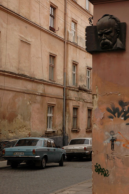
It’s a cool, damp morning on the 31st October 2011 as I drive across the Dniester River into Ukraine and the historical region of Podolia. From the border town of Mohyliv-Podilskyi I drive slowly north through backwater towns on winding and sometimes rough backroads, later turning east and reaching in the evening the attractive city of Kamianets-Podilskyi, where I am hosted by Gennadiy, a local sign-writer and his family. Kamianets-Podilskyi was first mentioned as part of Kievan Rus’, the pre-cursor state of modern Russia, Ukraine and Belarus, and was capital of Podolia from the fifteenth to twentieth centuries. Gennadiy’s apartment lies in the new city, which bears the ubiquitous architectural hallmarks of the Soviet Union, but it is in the ancient centre just a few hundred metres to the west that I realise I am somewhere quite different from the eastern and central regions of Ukraine through which I have recently passed. The old city of Kamianets-Podilskyi is situated on a bluff almost totally enclosed by a sweeping meander of the Smotrych River, which here has carved a deep, leafy gorge out of the native limestone. Here, life unfolds slowly on winding cobbled streets of pastel-coloured buildings, dotted with churches of both Orthodox and Catholic denominations, reflecting the long, historical influence of Lithuania and Poland in Podolia and indeed much of western Ukraine.

Castle, Khotyn, Chernivtsi Region, Ukraine
Aside from a modern bridge, the only connection between the old city and surrounding countryside is a neck of raised land, and immediately beyond this lies Kamianets-Podilskyi’s striking castle, which for centuries marked the border of the Polish-Lithuanian Commonwealth and withstood attacks from the Tatars and Ottomans, until being ceded to the Russian Empire in the eighteenth century following the second partition of Poland. Amidst the low cloud and damp, muddy Podolian countryside which lies beyond, the spectacularly sited castle paints a highly atmospheric picture of medieval Europe.
West of Kamianets-Podilskyi I meet the Dniester once more and cross briefly back into Bessarabia in the town of Khotyn which hosts another magnificent medieval castle, the last and most spectacular of a series of fortifications which have marked my journey up-river from its estuary below the windswept castle of Bilhorod-Dnistrovskyi on the Black Sea. From Khotyn, the road takes me south-west, crossing the Prut River into the historical region of Bukovina and the charming provincial capital of Chernivtsi.

Chernivtsi, Chernivtsi Region, Ukraine
Like Bessarabia, Bukovina was historically part of Moldavia, but whereas Bessarabia was annexed by the Russian Empire in the eighteenth century, Bukovina became part of the Habsburg and successor Austrian empires, and only came under Russian influence after the 1940 occupation of Northern Bukovina by the Red Army. Just across the Prut River, Chernivtsi is the principal city of Northern (i.e. Ukrainian) Bukovina, and with less than fifty years of Russian domination, feels a great deal less Russified than any other part of Ukraine I have yet visited. Here I have finally entered Western Ukraine, and begin to appreciate the stark divide between the west and east of the country. Not only is the architecture of the city decidedly different, but also the people, with bloodlines mixed with Romanians or Poles. The language is also different, with the softer tones of Ukrainian being spoken on the street; a far cry from Kharkiv or Dontesk. At once Chernivtsi feels more worldly and sophisticated, more European than the cities of the east, but it is also noticeably less smart and prosperous, for while the east of Ukraine has historically been an industrial powerhouse, these western regions are by comparison an agrarian hinterland.
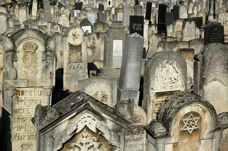
Jewish Cemetery, Chernivtsi, Chernivtsi Region, Ukraine
Known as a regional cultural and educational capital and sometimes referred to as ‘Little Vienna’ due to its Habsburg heritage, Chernivtsi lies amidst the eastern foothills of the Carpathians and is immediately attractive with its mixture of Neoclassical, Baroque and Gothic architecture. Elegant streets of nineteenth century pastel buildings with stucco facades, and numerous churches, parks and squares make for a very pleasant city to stroll in, but the city’s unexpected centrepiece is undoubtedly the huge, nineteenth century red-brick Residence of the Bukovinian and Dalmatian Metropolitans. Set on three sides of a grassy courtyard filled with box bushes and tall cypress trees, the residence building showcases a multitude of styles and architectural flourishes, such as the banded motifs of Ukrainian folk art which run across the roofs, Byzantine proportions of its integral church, and tall, stepped Romanesque entrance facades to what are now various faculty buildings of the city’s university.
What strikes me most about Chernivtsi however is its Jewish connection. In the early twentieth century, the population of the city was almost fifty percent Jewish and alongside Lviv, was one of the main Jewish cultural centres in the Pale of Settlement, a shtot (city) known as ‘Jerusalem on the Prut’. Today, scant traces of this past remain, with the Jewish population decimated by pogroms, the Holocaust and emigration following the collapse of the USSR. However, on a hill overlooking the city centre I find Chernivtsi’s Jewish cemetery, where row upon row of gravestones have recently been uncovered from the choking undergrowth in an ongoing operation. Many stones are elaborately carved works of art, testament to the former richness of Jewish culture, but aside from the caretakers wielding chainsaws and strimmers, this graveyard containing some fifty thousand interred is beautifully tranquil and almost deserted. Interestingly, many of the gravestones date from the 1970s and 80s, demonstrating that the Holocaust was not the end of Chernivtsi’s Jewish community, but rather the wane of Soviet control and rise of nationalism and anti-Semitism. Outside the cemetery stands a doleful synagogue, victim to the ravages of time with a rusted dome, peeling, damp walls and broken windows; a fitting monument to a lost and now almost enigmatic people in this surprising Habsburg city.
Carpathian Mountains, Ivano-Frankivsk Region, Ukraine
I leave Chernivtsi and drive north-east through open farmland to Ivano-Frankivsk, where I meet with Karolina once again. Founded in 1662 as Stanisławów, a private fortress of the Polish Potocki Family, Ivano-Frankivsk shares the Habsburg and Austrian history of Chernivtsi, though between the World Wars was part of Poland rather than Romania. With a heavier Soviet influence, Ivano-Frankivsk is a little less charming than Chernivtsi and with cold foggy weather descending upon the city, we head west into Europe’s second longest mountain chain, the Carpathians.
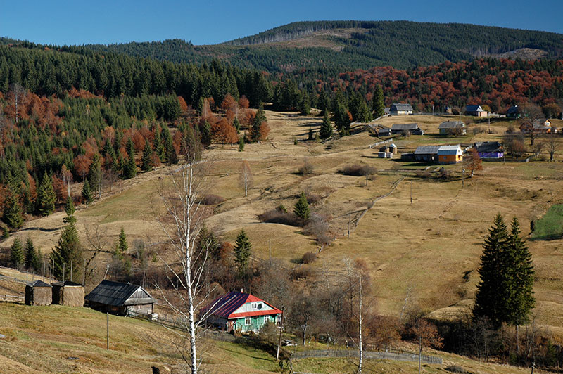
Shortly after turning south from the main road, we begin to climb and thankfully leave behind the fog and grey skies to emerge into radiant autumnal sunshine and gorgeous views of rolling hills, covered in primeval forests of green pines mixed with now-brown beech trees. On grassy hillsides between the stands of forest lie idyllic villages of colourful wooden houses, wicker fences and tall ricks of drying hay; a delightfully bucolic vista of pre-modern Europe. Our climb tops out at a little under one thousand metres at the Vyshkiv Pass, beyond which we descend into Transcarpathia, Ukraine’s most far-flung region.

Gorgany Mountains, Zakarpattia Region, Ukraine
The Outer Eastern Carpathians which we have just crossed have defined the border of the Hungarian Empire since the ninth century and Transcarpathia, or Carpathian Ruthenia, has since passed to the Habsburgs and Austria, then to Czechoslovakia between the World Wars, before incorporation into the USSR. Though Ukrainians today constitute a majority in Transcarpathia, there are sizeable minorities of Hungarians along the region’s southern border with Romania, and a number of Ukrainian ‘highlanders’; Hutsuls, Boykos and Lemkos, who are often collectively known as Rusyns, descendants of the Ruthenians.
In Mizhhirya we turn off the north-south road and climb east into the Gorgany Range and Synevyr National Park, one of the least populated areas of the Carpathians. We descend gently through very rustic villages such as Synevyr and Nehrovets, the latter of which has the fine early nineteenth century Archangel Michael Church built entirely out of wood in an architectural style characteristic of the region. We stop for the night in the large village of Kolochava, where we surprise the owners of a guesthouse by arriving so far out of season, and where we seem to be the only patrons.
The weather the following day is still perfectly clear, with crisp air and deep blue skies, and we set off early, following a stream north from the centre of the village, climbing up the curving spine of the Pyshkonya Ridge, first through dormant fields set with haystacks, then forests of spruce and beech, emerging high on the boulder-strewn ridge and spending several hours walking north, and then north-west on bare slopes of yellowing grass and occasional debris fields, reaching the 1707 metre high Nehrovets, the highest peak on the ridge. From here we have magnificent views of the rolling Carpathians which fall away into the distant haze in all directions on this beautiful day; a final glimpse of autumnal colour before the impending winter snows, and for myself a final indulgence in beautiful natural surroundings before returning to Western Europe.
It’s after dark by the time we descend from the ridge into the village of Nehrovets, and we’re grateful to hitch a lift for much of the ten kilometre walk back to the guesthouse in Kolochava, where we enjoy a good fireside meal. The following day we drive south down the Tereblya Valley, turning east at the end of the road and tracking the Tisza River which marks the Romanian border on a winding and at times quite scenic highway, looking south into the EU. Leaving the river valley, the road begins to climb, but the skies become dismal and grey once more and despite stopping for two nights in the small town of Kvasy, we decide against making any further walks in the mountains and leave the Carpathians without glimpsing Hoverla, Ukraine’s highest peak.
Market Square, Lviv, Lviv Region, Ukraine
Descending back to the edge of Ivano-Frankivsk, we head into Galicia, a region named after the medieval city of Halych which once was its capital. Galicia (initially united with more northerly Volhynia) was the westernmost of the states to emerge from the twelfth century collapse of Kievan Rus’ and subsequently passed to the Hungarians, Poles, Polish-Lithuanian Commonwealth, Habsburgs, Austria and, following heavy fighting in the First World War, was made part of the Second Polish Republic until the Soviet invasion of eastern Poland in 1939. Traditionally an agricultural and rather poor part of Europe, Galicia was populated mostly by Poles and Ukrainians, though like much of what was historically Poland was also a centre for European Jewry. During the twentieth century the borders and demographics of the region were brutally manipulated by vying powers, yet Galicia’s capital Lviv has somehow survived these ordeals physically unscathed and is Ukraine’s most attractive city; the cultural centre of the west of the country and a base of resurgent Ukrainian nationalism. We arrive after dark in the city, finding our way through the city’s winding old streets to our host Andriy, a native of Khust in Transcarpathia, who lives in an apartment in a nineteenth century town house rather than a typical Soviet housing block.
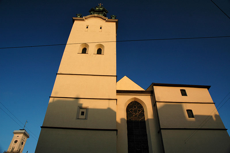
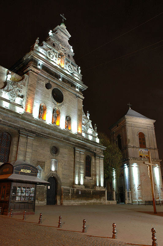
Latin Cathedral, Lviv, Lviv Region, Ukraine
Lviv was founded in the twelfth century by King Daniel of Galicia and Volhynia, and was named for his son Lev who, following the destruction wrought by the Mongols in the thirteenth century, rebuilt Lviv and transferred the capital here from Halych. Under the Polish-Lithuanian Commonwealth Lviv became a large urban centre, and despite numerous attacks by Swedes, Hungarians, Turks, Russians, Tatars and Cossacks (the latter of which were paid off to avoid capture of the city centre), the city prevailed. Under the Habsburgs and subsequent Austrian Empires, Lviv prospered and much of the city centre dates from this period, which latterly saw a flourishing of Polish, Ukrainian and Jewish culture until the Polish takeover in 1918, when Poles and Ukrainians engaged in a brief war.
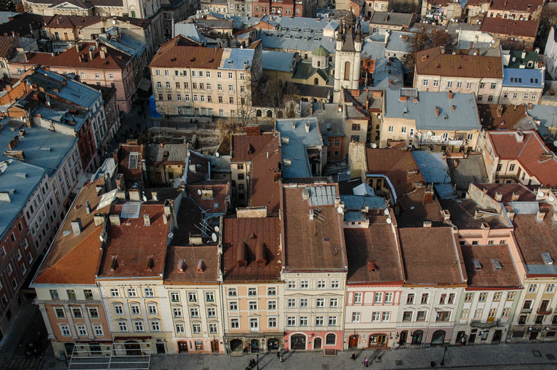
The morning after our arrival, Karolina and I begin to explore Lviv, which immediately impresses me with its elegant, harmonious urban architecture. Unlike Odessa, Lviv appears to live up to its beguiling reputation and whilst Chernivtsi and Ivano-Frankivsk are rather sleepy provincial capitals, Lviv bustles with activity. While by no means overlooked by tourists, the city remains dignified and seems at present not to have submitted to the full force of mass tourism as one would find in similarly beautiful cities in Central Europe. Crossing Freedom Avenue, we lose ourselves in the streets and alleys of the old city which is centred upon the central Market Square. In the middle of this stands the Viennese Classical Ratusha or city hall, whose nineteenth century clock tower is open to visitors.
Old City, Lviv, Lviv Region, Ukraine
From the top of the sixty-five metre clock tower one has a spectacular view of the old city from its very heart, revealing grandiose Habsburg residences amid rows of three and four storey town houses in pale shades of peach, buff or pink and with sloping red terracotta or grey lead roofs, clustered somewhat haphazardly around small yards. For once, the Soviet urban planners have had the sensitivity to locate their comparatively graceless concrete buildings mostly in the suburbs, preserving the visual character of the city. What is perhaps most delightful are the roofs, belfries and clock towers of the various churches, cathedrals and monasteries which protrude above the roofs in all directions, giving Lviv the feel of a European Samarkand, or a miniature Jerusalem.
To the north is the distinctive white tambour and conical roof of the Armenian Cathedral, used by the Polish-Armenian community until their expulsion from Ukraine following the Soviet takeover in 1945. To the east lie several churches; the beautiful Baroque sandstone of the Dominican Church, now belonging to the Ukrainian Greek Catholic Church; the Dormition Church, the city’s largest Orthodox Church with its huge, square-plan Gothic Korniakt Tower; the Baroque facade of the seventeenth century Carmelite Church, sitting on an ancient mound a little beyond the centre; the distinctive Church of Poor Clares with its almost Art-Deco features and which is now a sculpture gallery, and the patinated green dome of the seventeenth century Bernadine Church and Monastery. Immediately to the south-west is the imposing Baroque of the fourteenth century Latin Cathedral belonging to the Roman Catholics, next to which is the unusual Boim Family Chapel, built in the seventeenth century by a Lviv merchant in the Italian Renaissance style, but with an unusual two-tiered carving of religious figures in blackened sandstone, rather reminiscent of an Indian temple. Due west of the square is the newly restored Jesuit Church, dating to the seventeenth century and once one of the largest churches of the Polish-Lithuanian Commonwealth, and finally to the north-west the Church of the Transfiguration, neatly slotted into a city street and also now also belonging to the Ukrainian Greek Orthodox Church.
Bernadine Church, Lviv, Lviv Region, Ukraine
After two days enjoying Lviv’s attractive streets, Karolina must return to Warsaw, and I start to look beyond Lviv’s centre and consider a rather less attractive side of the city’s history. The Polish takeover of Galicia in 1918 following the collapse of Austria-Hungary upset the balance of power in a region claimed by both Poles and Ukrainians, leading to the repression of the Ukrainian language and of Ukrainian institutions, and an increase in anti-Jewish sentiment. The Soviet occupation in 1939 saw the Poles lose their hegemonic position once again, and the move was highly unpopular in a region with no history of Russian influence, particularly given the fresh memory of Holodomor, the Soviet engineered famine which killed millions across Ukraine and southern Russia. It is perhaps not surprising then that when, as part of Operation Barbarossa, the Nazis and their Axis allies occupied Galicia in 1941, local Ukrainian nationalist militia were quick to ally themselves with the Nazis, hoping ultimately to gain an independent state, and happy to assist in the implementation of Nazi policies, taking revenge on Poles, Jews (blamed for collaborating with former Polish landlords and for Soviet mass-murders of local prisoners) and Bolsheviks. Many Jews who had recently fled the Nazis as they advanced east through Poland, into Soviet occupied Galicia now found themselves concentrated in the Lviv Ghetto.
I walk east, away from the city centre, passing Klepariv Station and walking down a wide ring-road through the city’s outer western suburbs, passing a rather grim looking modern prison compound on my right. Just beyond here lies a neglected patch of land with a lone monument consisting of a large boulder, inscribed in Ukrainian, Hebrew and English, commemorating the (up to) 200,000 Jews who perished here; for this is the site of the infamous Janowska concentration camp. As Operation Reinhard, the Nazi’s ‘final solution’ for Polish Jews was carried out, Lviv’s ghetto was dissolved, with those fit to work being incarcerated at Janowska, and those deemed unfit deported to via Klepariv Station to nearby Belzec death camp in what is now Poland. Apart from this modest rock memorial and a few bunches of plastic flowers, there is nothing to commemorate this spot, and indeed on a nearby whitewashed wall there is some crude graffiti consisting of a crossed-out Star of David and a Nazi Swastika, a worrying sign of contemporary local sentiment. Closer to the centre one finds a larger monument to the exterminated Jewish population, albeit in a small, fenced-off square next to a busy road, though it too is an occasional target for vandalism.
When the Soviets ‘liberated’ Galicia in 1945, the population was again ethnically cleansed, with over 100,000 Poles expelled to Poland and anyone whom the authorities had any suspicion of having collaborated with the Nazis shipped off to join the millions in Stalin’s Gulag system. Nevertheless, Lviv remained a major centre of the dissident movement throughout Soviet times, and today is, alongside Kyiv, the centre of the Ukrainian nationalist movement, playing a key role in modern Ukrainian politics.
Despite the grisly history, I leave Lviv after four full days of exploration with very positive impressions; perhaps a little surprised that what is just about the last city in the Former Soviet Union which I will visit on this four-and-a-half year journey, is also one of the very nicest.
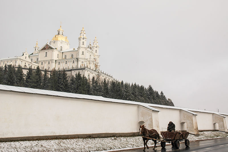
Pochayiv Lavra, Pochayiv, Ternopil Region, Ukraine
From Lviv I drive east on a good, recently surfaced road which leads eventually to the capital, and encounter my first real snow of the year; beautiful in the fresh white covering which it gives to the muddy autumnal landscape, but a harbinger of a long, cold winter I am keen to escape. I pass the ancient castle of Olesko, sitting on a small hill surrounded by a snow-dusted marsh of reeds and wild grasses. A little beyond I enter a corner of Ternopil Region, part of the medieval state of Volhynia which shares much the same history as Galicia up until its incorporation into the Russian Empire in 1795. I make a stop in the small town of Pochayiv, where the muddy fields and horsecarts of rural western Ukraine are overshadowed by the huge, walled lavra (Orthodox monastic complex).
Pochayiv Lavra was first mentioned in the sixteenth century, famed for its miracle-working icon. Despite an interregnum of Greek-Catholicism before Volhynia’s transfer to the Russian Empire, the lavra has long been a spiritual centre of Orthodox Christianity in the region, and since the nineteenth century has been the western outpost of Russian Orthodoxy, resisting Soviet religious persecution to remain functioning throughout the Soviet period, and now resisting takeover claims from the Ukrainian Orthodox Patriarchate and Ukrainian Greek Catholics. In contrast to Lviv’s strongly European influenced architecture, Pochayiv is immediately recognisable as Russian Orthodox with its gleaming golden domes and distinctive three-beamed crosses, and teems with pilgrims from across the Former USSR and the Balkans, though its impressive external appearance gives way to a rather ordinary interior.

Lubart’s Castle, Lutsk, Volyn Region, Ukraine
Continuing north from Pochayiv I’m taken by surprise in the nearby town of Kremenets when muddy, rural Ukraine again gives way to the beautiful, ornate Baroque Franciscan Abbey, overlooked by the remains of a medieval fortress on a craggy ridge. A little later, I make a brief stop to see Dubno’s riverside castle, then continue to my very final destination, the city of Lutsk, once capital of Volhynia. Though host to the beautiful fourteenth century Lubart’s Castle, built by a Lithuanian king, the town is otherwise rather ordinary. Damaged and heavily and depopulated by the events of the twentieth century, with its former Jewish population murdered by Nazis and Ukrainian nationalist extremists, and its Polish population either deported or expelled by the Soviets, Lutsk’s rather spread out and nondescript city streets gives one the impression that the city has never recovered. Lutsk’s Grand Synagogue, built in restrained, blocky Renaissance style has somehow managed to survive the Nazis and Soviets, a rather sorry reminder of a departed past with peeling plaster walls, now used as a sports club.
I leave Lutsk after dark, making the final journey via Kovel to the border crossing at Yahodin where, after waiting in long queues of Polish cars, I cross the Bug River in the early hours of the 18th November, entering the European Union and thus essentially ending the journey rather uneventfully, in the middle of the night, surrounded by small time traders and fuel smugglers.
I stay with Karolina for just over a week in Warsaw, after which we say a final goodbye and I continue west. I stop with family in Jena, just as I did on the outward leg of the journey, and spend a day in Brussels with Koen, a Dutchman I had met in Iran in early 2010, before catching the ferry from Dunkirk back to Dover. Here I am greeted back to the UK by wretched skies and torrential rain on the M20, but after getting slightly lost on narrow Kentish backroads, I arrive back where I started 1671 days and 155,681 kilometres earlier, at my childhood home in Hawkhurst, late in the morning of the 1st December 2011.
