
Stage 30 – Russia & Ukraine: Chernozem, Donbass And Crimea [2/2]

I drive across the Dnieper River on 10th September 2011 and enter Kyiv, the Ukrainian capital where I am hosted by Mykola, a paramedic who lives with his mother in the extreme north of the city. Back in June 2007, a night spent in Kyiv on my way east at the very beginning of the Odyssey had been my first encounter with the Former USSR and the Russian-speaking world, and I imagine what it would be like to bump into myself, now at the end of my trip, four years, four months and four days later, having become so familiar with the former Soviet world.

Podil, Kyiv, Ukraine
Kyiv grew up as a city on the trade route between Scandinavia and Constantinople and was part of the Khazar Khanate, a semi-nomadic Turkic civilisation which controlled much of the western Silk Road in the Volga – Don region during the seventh to tenth centuries. The city was then seized by the Varangians and became capital of Kievan Rus’ in the ninth or tenth centuries, the progenitor of modern-day Russia, Ukraine and Belarus which would give rise to the first Rurikid Dynasty of Russian Tsars. Kyiv would have been one of the world’s largest cities prior to the Mongol invasion of 1240, when it was completely destroyed and would remain relatively obscure throughout the following period of incorporation into the Polish-Lithuanian Commonwealth and Russian Empire, only regaining prominence during the nineteenth century industrialisation of Imperial Russia. Kyiv was the third largest city of the Soviet Union and became the capital of Ukraine following independence in 1991, and plays an important role as the cultural capital of the pro-European Ukrainian identity whose proponents are very keen to distance themselves from the Russian-dominated past.

St Michael’s Golden Domed Monastery, Kyiv, Ukraine
Kyiv is an immediately likeable place, attractively sited next to the deep blue Dnieper River on a number of hills, with a centre of wide streets of often elegant city blocks, squares and parks. It’s a far nicer city than Moscow for example, with a more upbeat and laid back atmosphere, though it is visibly more European and rather less exotic, with crowds of tourists and English frequently heard on the street. I start a walk around the city from the very centre, in Independence Square where a tall column topped by a statue of Berehynia, a female spirit from Slavic folklore which has recently been adopted as a symbol of the Ukrainian independence movement has replaced Lenin on his plinth. North-east of the square I pass through the Soviet-era Friendship of Nations Arch and enter the long city park which is spread along the right bank of the Dnieper with beautiful views across to the left bank and the city’s smaller eastern segment. Here the city’s bright high-rise suburbs look almost like an island, surrounded by an uninterrupted sea of green, arboreal endlessness spreading to the horizon. Looking east across such a wide open space causes me to pause for a moment and imagine the wild expanses of steppe which stretch off for thousands of kilometres to the east, a magnificent landscape I will surely miss on my return to western Europe. Back in the centre, to the north and above Independence Square is the beautiful St Michael’s Golden Domed Monastery, originally built in the eleventh century, but totally destroyed by the Soviets in 1935, having only recently been rebuilt. Facing the monastery down a wide street several hundred metres in length is the slightly older, though less visually arresting Saint Sophia’s Cathedral, with both structures being considered masterpieces of Ukrainian Baroque. Outside Saint Sophia’s this showcase of Ukrainian independence is completed with a large statue of Bohdan Khmelnytsky, the hetman (head of state) of the Zaporizhian Cossack Host who led an uprising against the rule of the Polish-Lithuanian Commonwealth in the seventeenth century and effectively established an independent Cossack State, a mooted progenitor of an independent Ukraine.

Dnieper River, Kyiv, Ukraine
I leave Kyiv and Ukraine to spend just over two weeks with Karolina in Warsaw, during which time I decide upon a subject to study for a master’s degree upon returning to the UK at the end of the year; a decision which would come to dictate my future career. When I return to Kyiv in late September, I find that late summer has transitioned into autumn, with warmth and deep blue skies replaced by cool, damp weather and glorious autumnal colours. I return to the Dnieper’s right bank, to the Kyiv Pechersk Lavra, an eleventh century cave monastery which has become one of the most important centres of Eastern Orthodoxy, chief monastery of the Ukrainian Orthodox Church and residence of its metropolitan. Beyond the lavra lies a sculpted Soviet-era park celebrating victory in the Second World War with monolithic, brutalist concrete architecture, bronze dioramas of valiant Red Army soldiers and the sixty-two metre high Motherland Monument; a mother of Ukraine holding up a shield with the Soviet coat of arms and a sword, later truncated so as not to stand higher than the highest cross of the nearby lavra.

Andriyivskyy Descent, Kyiv, Ukraine
From the park I return to the city centre, past the lavra and on to the memorial and museum dedicated to the Holodomor, the Ukrainian term for the Soviet famine of 1932-33 which killed perhaps six to eight million people in what is today Ukraine, Russia, Belarus and Kazakhstan, of which four to five million are thought to have been Ukrainian. Holodomor, literally meaning ‘extermination by hunger’ has become a contentious international (and domestic) issue, raising the issue of whether the famine was a deliberate attempt to wipe out the Ukrainian people. The museum contains graphic images of the sufferings of Soviet Ukrainians during the famine years, but what lingers in my mind most is the pointedly anti Russian sentiment, with the famine being blamed roundly on Russians, rather than Soviets, and the whole museum has more than a touch of fanatical nationalism. Continuing through the park, I end up in the riverside district of Podil, one of Kyiv’s oldest, which I also recognise to be the neighbourhood in which I spent a night in a hostel in 2007 after blindly navigating my way across the city. From Podil’s slightly gritty, riverside charm I walk past a number of churches which have survived the Soviet period, climbing finally along Andriyivskyy Descent, lined by stalls selling tat to tourists, past the striking though gaudy Baroque of St Andrew’s Church, down Volodymyr Street to the Golden Gates, the completely restored (largely from imagination) main gate of the eleventh century fortifications of Kievan Rus’, where I get onto the Metro back to Mykola’s apartment.
Petrovskogo Square, Dnipropetrovsk, Dnipropetrovsk Region, Ukraine
I leave Kyiv having experienced the assertive character of the modern though deeply-rooted Ukrainian identity, something I had barely encountered in the east of the country. I make my way south-east on a cool Sunday morning, following the corridor of the Dnieper River which bisects the country, passing through the pleasant, tree lined centre of Cherkasy, crossing the river in Kremenchuk and cutting slightly inland, through rolling farmland which seems to be bracing itself for the impending winter. This region south of Kyiv, on the left bank of the Dnieper was historically known as the ‘Wild Fields’, and was an area depopulated by raiding semi-nomadic Nogays, and a warpath across which Imperial Moscow and the Crimean Tatars would invade each other’s territory. Cossacks first tamed the tribes in this area, but it was Catherine the Great who incorporated it into the Russian Empire in 1764, renaming the area ‘Novorossiya’, literally ‘New Russia’. I stop for the night in Dnipropetrovsk, Ukraine’s third largest city originally named Yekaterinoslav and proclaimed capital of Novorossiya. A closed city during Soviet times, Dnipropetrovsk was famous for its nuclear, arms and space factories, collectively known as Yuzhmash and ostensibly manufacturing tractors and kitchen appliances.
Dnipropetrovsk remains a thoroughly industrial city, a commercial and political powerhouse, rather more down-to-earth though far less charming than the capital. The city centre is a mix of grandiose early Soviet blocks, wide avenues, squares, and shining new glass-fronted skyscrapers, and it is only at the regional museum, whose courtyard is filled with balbals (kurgan stele) from the surrounding countryside, that I am reminded that this region was until relatively recently, culturally far closer to the steppes of Central Asia than of settled Europe.

Kurgan Stele, Zaporizhia, Zaporizhia Region, Ukraine
I leave the city heading due south on a busy, divided highway which parallels the Dnieper, making the short journey to the city of Zaporizhia after dark. Like Dnipropetrovsk, Zaporizhia is a largely industrial city, though without the same air of dynamism and prosperity. Zaporizhia grew up as a modern Soviet city around the Dnieper Hydroelectric Station, built with the assistance of American engineers during the period of heavy Soviet industrialisation in the 1920s and 30s, though it has a far more prominent role in Ukrainian history as the base of the Zaporizhian Host, or Cossack Hetmanate (state) founded by Cossack hetman Bohdan Khmelnytsky. The origins of the Cossacks are thought to lie in Slavic serfs and criminals escaping feudalism and incarceration during the times of the Polish-Lithuanian Commonwealth, mixed together to some extent with native Turkic groups such as the Cumans. Once allied with the Tsardom of Russia, the Cossacks would help to drive Polish-Lithuanian elements from the region of the left bank of the Dnieper in the seventeenth century. Later, under Catherine the Great, the Cossack state would be ruthlessly disbanded, with Zaporizhian Cossacks fleeing to the Danube and Russia’s Kuban Region. The Zaporizhian Cossacks traditionally lived on the riverine island of Khortytsia, close to the rapids on the Dnieper (now submerged by the dam) and which today separates the eastern and western halves of modern Zaporizhia. Here one finds their beautifully reconstructed sich (military encampment), though the island’s kurgans (burial mounds) and stele hint at a history which extends into the Cuman or perhaps even Scythian period, pre-dating even the Cossacks.

Khortytsia Sich, Zaporizhia, Zaporizhia Region, Ukraine
In Zaporizhia’s spread-out and rather down-at-heel centre, I take a walk along the shore of the reservoir which the Dnieper has become, looking out on this mild but grey day across to the cranes and docks of the far bank. It is here that I encounter Nikolay, a bright-eyed old street sweeper with a few days’ of stubble and a battered hat, who immediately engages me in conversation; stating that former prime minister Yulia Timushenko is a bandit, along with a number of her cronies, though he is most visceral about Russian-Jewish oligarch Boris Berezovsky, whom he maintains was the mastermind of the September 11th attacks on the United States. Nikolay claims he was a general in the Soviet Army, and tells me of fast breeding nuclear reactors and prototype laptops during Soviet times. Finally, he asks me: ‘You know how the Soviet Union collapsed?’ ‘No’ I say, lacking the Russian to explain my understanding of the root causes of the matter. ‘It was me! There was a Lenin Statue there’ he says, pointing across to the port. ‘I was there. I went to a small cafe in 1987 and bought an ice cream and lemonade with five roubles. Then I got in my tractor, gunned the accelerator and smashed the statue.’ ‘And what happened then?’ I ask, unable to contain my laughter, though Nikolay is also laughing at his animated story. ‘The KGB came, but when they saw who I was, they got a fright, and that was the end of that. They picked it up and threw it away!’ At no point in our conversation does the fact that he is a shabby street sweeper smoking the cheapest papyrosa (unfiltered cigarettes) reduce his credibility, and he’s obviously an intelligent person, which makes me wonder, upon pulling myself away from his wild stories, if there might be an element of truth to them.

Yeni Kale, Kerch, Crimean Autonomous Republic, Ukraine
Beyond Zaporizhia I soon leave the Dnieper and head due south through Melitopol towards the coast of the Azov Sea, where in a scrubby area of sand-spits and salt marshes I cross onto the Crimean Peninsula, an autonomous republic within Ukraine. Historically poised between the classical world and the civilisations of the steppe which spread almost endlessly to the east, Crimea has long been a nexus of various empires and has an exceptionally rich and varied history. Greeks, Persians, Romans, Byzantines, Genoese, Venetians and Ottomans have all settled the Crimean peninsula, in addition to numerous semi-nomadic empires from the surrounding steppe, most notably the Crimean Tatars who founded an independent Crimean Khanate following the Mongol withdrawal, and ruled until the Russian takeover in 1783. Most recently, in 1954, Khrushchev transferred the majority Russian Crimean Peninsula to the Ukrainian SSR for reasons which are not entirely clear, and perhaps even controversial.
The atmosphere of Crimea is noticeably different from that of the rest of Ukraine. It’s not because of the landscape; the rolling, barren grasslands in the north which evoke Kazakhstan or Mongolia. Nor is it the forlorn or even half-derelict villages of the interior which sit largely quiescent, like small, forgotten kolkhozes (collective farms) out on the torrid steppe of Central Asia. It’s also not the glut of tourists and seedy amenities provided for them, which makes it about the most obviously touristy part of the Former USSR I have yet seen. What really makes a noticeable impression are the faces of the people; hard, weather-beaten faces with a melting pot of features from pure Slavic to Asiatic, and a slightly coarser, less European street attitude which makes Crimea feel far more like Russia than Ukraine. Small observations such as Ukrainian road signs which have been changed to Russian spellings by peeling off a letter or alteration with spray paint hint at an underlying tension and resentment of Ukrainian nationalism from some of the Russian population.

Docks, Kerch, Crimean Autonomous Republic, Ukraine
My first stop in Crimea is the city of Kerch, a slightly shabby but charming port city overlooking the Kerch Strait, which separates Crimea from the westernmost point of Russia’s Black Sea coast. I’m hosted here by Vlad, a tallyman for a French shipping company, who shows me his city and its surroundings. Kerch is one of Crimea’s oldest cities and was founded twenty-six hundred years ago as Panticapaeum, a Greek colony whose sparse fragments of toppled limestone pillars and temple floors dot Mount Mithridates in the centre of town. From this ancient hill one can look across Kerch, to a view damaged by war and neglect, over the attractive, pure Byzantine eighth century church of St John the Baptist towards the still busy docks. In the vicinity of Kerch Vlad shows me a string of noteworthy sights, starting with the huge ‘Royal Tomb’, a well preserved kurgan (tumulus) thought to date to the fourth century BCE during the time of the Bosporan Kingdom, a Roman client state. One enters the kurgan along an impressive, steep limestone dromos which, rather like a huge birth canal, leads to the magnificently vaulted, though empty central chamber. Further to the north east we take Vlad’s Zhiguli off-road across the steppe to reach a group of mud volcanoes which gently spew cold mud to the surface in a barren moonscape of dessicated mud, then return to the coast to finish our tour at Yeni Kale, a neglected Ottoman castle built overlooking the Kerch Strait in the early eighteenth century during the time of the Crimean Khanate. For early October the weather is beautifully warm and sunny, with views across to Port Kavkaz in Russia, and I start to see why Crimea was one of the prime holiday destinations of people from across the USSR and Eastern Bloc.

Genoese Fortress, Sudak, Crimean Autonomous Republic, Ukraine
Vlad is half-Russian, half-Ukrainian, though clearly identifies Russia as his homeland. He’s sceptical of Ukrainian nationalism, something he very clearly wants to distance himself from, and views Ukraine as something of an artificial country. ‘Those people in the west are totally different from us, we can’t live with them.’ ‘So what is the solution?’ I ask. ‘We should be apart, two separate countries. They will have their capital in Kyiv, which is a den of nationalists, and ours will be in Kharkov’ (not Kharkiv, the Ukrainian appellation).
I’m beginning to see the extent to which Ukraine is divided regionally and question the identity of the country as a whole, with Vlad’s word’s in my mind as I head west across the steppe, entering more fertile territory beyond Feodosia where vineyards run up the mountain slopes. I stop in the small town of Staryi Krym, once perhaps capital of the Crimean Khanate and with a fine, beautifully carved though partially ruined Ottoman-style mosque which looks to be straight out of rural Anatolia. Heading south, I cross the rugged limestone peaks of the Crimean Mountains whose slopes are ablaze with magnificent autumnal colours, dropping down to the famed Crimean Riviera and the attractive resort town of Sudak, where I am hosted by Rimma, a Russian-Jewish woman originally from Vorkuta in the frigid polar north of European Russia.

Black Sea Coastline, Novyi Svit, Crimean Autonomous Republic, Ukraine
Sudak is understandably a popular tourist resort and buzzes with holidaymakers from across Ukraine and Russia. The town shares in Crimea’s long history of successive empires, but was famed as a staging post and trade centre of the Silk Road in the thirteenth and fourteenth centuries, giving it a tantalising link to the desert cities of Central Asia from which I have recently arrived. Without doubt, the town’s main attraction is its magnificent Genoese fortress with walls and towers of serried battlements draped over the dramatic, grassy limestone cliffs, evocative almost of the Great Wall of China at the farthest end of the ancient Silk Road. The fortress overlooks a beautiful bay, but it is a few kilometres to the west, in the village of Novyi Svit (literally ‘New World’) that one sees some of Crimea’s most magnificent scenery. Novyi Svit is a beauty spot famed throughout the Former USSR both for its views and for sparkling wine, and is a little more upmarket than many of Crimea’s resorts. There are still hordes of tourists around, though I manage to steal myself away from the trail across the coastal cliffs, scrambling down to the shade of an emerald-green Austrian pine for a blissful hour or so, looking across the azure waters of the Black Sea to towering outcrops of jagged limestone. I walk back all the way to Sudak, enjoying the last warm evening of the season whilst passing vertiginous limestone cliffs popular with climbers where ornate, straggling pines cling to the sheer slopes like pieces of Chinese miniature art.

Swallow’s Nest, Haspra, Crimean Autonomous Republic, Ukraine
Heading west, the road winds up into the hills, dropping down occasionally past vineyards and through the coastal town of Alushta, climbing once again before dropping slowly down into Yalta, which I immediately dislike for its downmarket resort atmosphere. On the city’s southern edge I pull in to visit the Livadia Palace, the summer retreat of the last Russian Tsar where Churchill, Roosevelt and Stalin shaped the post-war world, but the tourist hordes and parking mafia cause me to flee. I stop briefly in Haspra, a nondescript coastal settlement famous only for the ‘Swallow’s Nest’, the iconic pleasure castle of Baron von Steingel, a rather underwhelming Neo-gothic folly which nevertheless draws crowds. Indeed, so far I’m rather disappointed, though hardly surprised at the volume of tourism here, even in mid-October, and so continue directly on the city of Sevastopol. My vision of Sevastopol as I enter the city’s eastern suburbs is one of neglect and decay; of broken, litter-filled streets through slum neighbourhoods where children and adults busy themselves in the litter bins.

Chersonesus, Sevastopol, Ukraine
Despite all the romance attached to the city’s name, Sevastopol is in fact a relatively young place, founded in 1783 by a Scot in the service of Russia. The bay around which the city is focussed has however long been a strategically important port and it is here, on the coast to the west of the modern centre, that one finds Chersonesus, the most impressive Greek ruins in the Former USSR. Founded in the sixth century BCE by the ancient Greeks, Chersonesus passed to the Romans, Huns and then Byzantines who used the far-flung port as a place to monitor the barbarian tribes who lived beyond, and as a place of exile for deposed popes and emperors. Its most important moment in history came in the 980s when the city was absorbed in Kievan Rus’ and is where, legend has it, Vladimir the Great, the Varangian prince of Novgorod who conquered a huge swathe of land from the Baltic to what is now Ukraine, was ordained into Christianity, thereby largely ending the pagan era of Kievan Rus’ and sewing the roots of the modern Eastern Slavic Orthodox Church. The spot where this supposedly happened is commemorated with a modern church, but the ruins of ancient Chersonesus are far more attractive, presenting a view which is pure Greek; of low remains of buildings and walls and tall, lonely Corinthian columns of white limestone set against an azure sea.

Balaklava Harbour, Sevastopol, Ukraine
On the southern side of the peninsula, just beyond the outer suburbs of Sevastopol lies the small town of Balaklava, infamous for the ‘Charge of the Light Brigade’ which took place in the valleys immediately to the north; a botched cavalry charged which saw huge losses for the British during the Crimean War of 1853-56, when France, Britain, the Ottomans and Sardinia fought to stop Russian expansion into lands of the weakening Ottoman Empire. Balaklava is centred around a beautiful harbour, far more refined than anything in Sevastopol proper and with a distinctly Mediterranean atmosphere. Small, quiet, streets wind past the whitewashed buildings of the harbour which is packed with colourful wooden fishing boats and beyond, millions of dollars worth of yachts and cabin-cruisers belonging to the rich, though the atmosphere remains surprisingly down-to-earth. On the far side of the harbour is the astounding submarine base, built into the mountainside and supposedly capable of withstanding a direct nuclear attack, whose only opening is a tiny aperture in the sheer cliff, totally hidden from the open sea. Completed in 1957 after years of searching for a suitable location, the submarine base was one of the most strategically important military installations in the USSR, ensuring that Balaklava was for years a tightly closed place. Today the base is a museum, one of the more romantic relics of the Cold War, but Balaklava is refreshingly free from tourists compared to the resorts to the east. I climb up above town to the ruinous Genoese fortress, from where there are magnificent views across the glimmering ultramarine of the Black Sea, though the view towards town is rather marred by Soviet concrete. It strikes me here just how ugly Soviet architecture is when put against such benignly beautiful surroundings, rather than the harshness of the great steppes of Siberia or Central Asia.

Sevastopol Bay, Sevastopol, Ukraine
Although rough around its edges, Sevastopol soon grows on me as a characterful and even charming place, though in spite of having seen the more elegant parts of the centre, I can’t help but feel that Sevastopol has the seediest air of any city I’ve visited in the Former USSR with plenty of pale, yellowing citizens of various facial features, alcoholics, vagrants and cigarette beggars. It’s a city associated almost singularly with war and the centre is awash with monuments to navies, armies, sailors and soldiers. It is one of the twelve Hero Cities of the USSR, complete with a typically brutalist Soviet memorial square in memory of the destruction wrought by the Second World War. Today the Russian and Ukrainian navies exist rather uneasily together in the city’s bays, and Sevastopol was in fact subject to Russian territorial claims (as a separate territorial entity to the rest of Crimea) until 1997 when a long-term lease agreement was reached. Nevertheless, the Russian tricolour can be see all over the city buildings, making Sevastopol feel distinctly un-Ukrainian. Huge blue-grey warships prowl across Sevastopol Bay out into the open sea amidst considerable harbour traffic, and the cheap passenger ferries which cross from the city centre on the southern side of the bay to the scruffy suburbs on the north side make for a nice way to see the city. There’s even a touch of the bustle of the Bosphorous about Sevastopol Bay, though the city itself could hardly be compared to İstanbul. In the late afternoon a brief storm breaks, streaking the sky with magnificently coloured and textured clouds at sunset, against which Sevastopol’s testaments to centuries of conflict are magnificently silhouetted, a pleasant final image of this romantic port.

Mangup Citadel, Crimean Autonomous Republic, Ukraine
I leave the Crimean coast the following day, driving north-east into the low limestone outcrops which dot the surrounding farmland and are covered by mixed forests of oak, beech, chestnut and pine, beginning in their higher, cloud-wreathed reaches to show spectacular autumnal colours. The natural softness of the limestone, and defensive qualities of these towering white cliffs have led to the creation of several so-called cave cities, hidden away among the forests, far from the busy coastline. I stop first to visit Mangup, thought to be the historic Doros, the city of the Crimean Goths. I leave the truck and begin walking through damp, overgrown forest, passing some long-abandoned gravestones bearing Hebrew inscriptions, graves of either Krymchaks or Karaites, obscure groups of Crimean Jews whose origins are not clear, though Jews have been recorded in the region since the days of the ancient Greek colonies. Reaching the top of the escarpment the forest ends and I’m on a windswept moorland dotted with remains of buildings and a very impressive castle wall in an advanced state of decay, but still showing a beautiful and strongly Celtic-looking frieze around one of its remaining doorways. In nearby Eski Kermen, which I visit the following day, there is no castle but instead an impressive array of rock-hewn dwellings, two churches and even an ancient cart-road cut through the limestone and showing signs of the passage of wheels.
Bakhchysarai, Crimean Autonomous Region, Ukraine
My last stop in Crimea is the former capital of the Crimean Tatar Khanate, Bakhchysarai, with its beautiful Khan Saray, the only surviving palace of the Tatar Khans (military rulers) which has been carefully restored and sits in a leafy, autumnal courtyard, looking to have been lifted straight out of Turkey. Having started as the cave city of Chufut Kale, carved from the limestone cliffs above town, Bakhchysarai is a likeable place with small streets, mostly untouched by Soviet urban planning and dotted with iconic, needle-like minarets of Ottoman-style mosques. Indeed, wandering these back streets, where women return from shopping wearing hejab, it would be easy to forget that one is still in Ukraine. Nevertheless, with its rundown, provincial air, Bakhchysarai is clearly a shadow of it’s former self, highlighting the long-troubled relationship between the Crimean Tatars and the Russian state.
The Crimean Tatars are thought to have formed as a group from the various Turkic tribes who moved into Crimea from the thirteenth to seventeenth centuries. In the fifteenth century the Crimean Khanate emerged as an Ottoman vassal and successor state to the Golden Horde incorporating Crimea and parts of what is now Ukraine and Russia, around the Azov Sea. With a history of leading raids into Russia and clashing with the Cossacks of Zaporizhia, the Crimean Tatars were incorporated into the Russian Empire in 1774, but remained a majority in Crimea until the mid-nineteenth century. The Crimean Tatars suffered greatly during Soviet times, with famines in 1921 and 1931-33, and disastrous collectivisation in 1928-29 decimating the population and driving them into exile. Finally, in 1944 Stalin, suspecting the Crimean Tatars as potential fifth-columnists, deported almost the entire population to Central Asia. Although officially allowed to return since 1967, relatively few have done so and little state support has been offered. Many Crimean Tatars today live as a diaspora in Turkey and Central Asia.
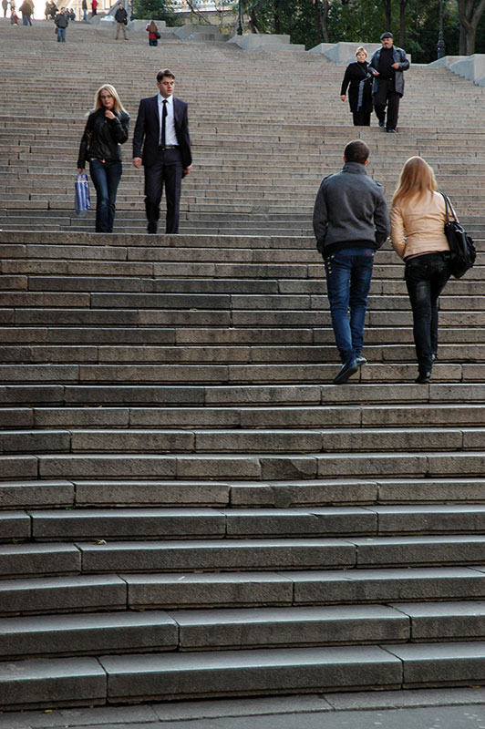
Potemkin Stairs, Odessa, Odessa Region, Ukraine
I cross the northern reaches of the Crimean Peninsula through flat, open farmland very different from the dramatic southern coast, back into mainland Ukraine, crossing the Dnieper River one final time in Kherson (whose name is a shortening of Chersonesus), re-entering the fertile Black Soil region and passing the shipbuilding city of Mykolaiv on my way to Ukraine’s fourth largest city, Odessa.
Odessa was founded by Catherine The Great in 1794 on the site of an earlier Tatar settlement, became the fourth largest city in the Russian Empire and later the most important port in the USSR. Among cities in the Former Soviet Union Odessa seems to evoke considerable romance in the Western imagination for its fine streets and cosmopolitan, Bohemian atmosphere; a roguish port city poised somewhere between Europe and Russia. I myself have considerable expectations prior to my visit, which takes place more than four years later than initially planned. What I find however comes rather short of expectations; though not unpleasant, Odessa is a city heavy with western influences in its Baroque, Renaissance, Fin de Siecle and Art Nouveau architecture, reflecting long-gone days of cosmopolitanism. Any atmosphere of intrigue or debauchery seems heavily diluted by the vulgar Ukrainian business class in their black SUVs and hordes of tourists erupting from a German cruise ship which has recently docked. There are few specific sights, though despite my now peevish attitude towards the hype, I’m still impressed by the Potemkin Stairs, the 192 steps which lead up from the harbour to the heart of the city, ending below a statue of the Duc de Richelieu, the prominent French statesman who became governor of Odessa in the early nineteenth century and was responsible for much of the early design of the city.

Akkerman Fortress, Bilhorod-Dnistrovskyi, Odessa Region, Ukraine
I leave Odessa feeling rather disappointed, driving out of the city’s southern suburbs through the sprawling port of Illichivsk on rough roads. I cross the huge estuary of the Dniester River, recently emerged from Moldova and enter Bessarabia which immediately feels far from Ukraine’s dynamic cities and from the tourists of Crimea; a far-flung frontier, a neglected borderland which starts to blend into Romania and central Europe. I make a brief detour to the town of Bilhorod-Dnistrovskyi, an ancient city with a history similar to that of Crimea’s older cities, and the last Black Sea port to be incorporated into the Ottoman Empire. I stop to explore the imposing Akkerman Fortress on a windswept bank of the Dniester estuary, built in the thirteenth to fifteenth centuries to defend this strategic access point to the Black Sea. Continuing west, I aim for the Danube which here marks the Romanian border.

Vylkove, Odessa Region, Ukraine
Not far beyond Tatarbunary I turn south, aiming for the Danube Delta and reaching Vylkove, the last settlement on the river. Here, amid the endless willow stands and reed beds of the delta is a small town whose houses are linked as much by canals as by roads, with locals taking motorboats from jetties outside their houses out onto the river to fish. Despite its isolation in the far south of the country facing Romania across the Danube, much of the population of Vylkove is actually Russian; Lipovans, a group of Old Believers who settled in this area when it was part of the Principality of Moldavia following persecution in the Russian Empire for opposing the reforms made to the Russian Orthodox Church in the mid seventeenth century.
I drive west on broken roads roughly parallel to the Danube through the sleepy towns of Kiliya and Izmail to Reni, the last settlement in Ukraine. Ahead of me lies Moldova, my next destination, and less than a kilometre beyond that Romania and the EU.
In the weeks I’ve spent driving through Ukraine, I’ve been very surprised by the diversity of the country; though equally surprised to leave without any clear impression of a Ukrainian identity between the russified borderlands of the east, the rural beauty of the north, the nationalist fervour of the capital, the Soviet industrial cities and Cossacks of the centre, and the absolutely heterogeneous population of Crimea. I would in fact see a totally different country on my next visit, en-route to the EU and UK. First however, I was looking forward to a completely new country, my fourteenth of the Former Soviet countries; Moldova.
