
Stage 39 – Iran & Iraq: Kurdistan And Assyria

The rugged Zagros Mountains of north-western Iran and northern Iraq are part of the greater region of Kurdistan, homeland of the Kurds. Whilst in Iran the Kurds are a marginalised minority, in Iraq the Kurdistan Regional Government (KRG) controls a swathe of Iraqi territory autonomous from the Baghdad government which has remained peaceful and secure whilst much of the rest of the country has descended into chaos following the 2003 US-led invasion. Historically, these mountains on the northern fringes of Mesopotamia have been at the heart of Assyria, the ancient empire of the indigenous Assyrian people, one of the world’s earliest civilisations. Today the Assyrians are a minority whose religious distinction as Christians in an overwhelmingly Muslim region sees their renewed persecution from the barbaric actions of ISIL, who present an existential threat to the descendants of a culture which dates back perhaps as far as the twenty fifth century BCE.
It has long been a dream of mine to visit Iraq, but due to security issues and visa restrictions, much of the country remains off limits. In June 2014 however, the Peshmerga (Kurdish security forces) had seized control of the city of Kirkuk, an oil-rich city long fought over by its Kurdish, Turkmen and Arab inhabitants, giving me the opportunity to visit a large Iraqi city beyond the usual borders of the autonomous Kurdistan region.
Whilst the region has some beautiful scenery, it would be the surprising cultural diversity that made the strongest impression upon me; a patchwork of nations including Kurds, Assyrians, Yazidis, Turkmens and Arabs. The people I met would welcome me with extraordinary generosity and often share deeply profound experiences of life in this troubled region, against a backdrop of nearby war and humanitarian crisis. It would be an unforgettable insight into modern-day Kurdistan and Assyria.

Khodaafarin Bridge, East Azerbaijan Province, Iran
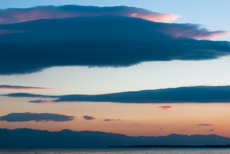
In the afternoon of the 4th October 2014, I cross the Aras River from Armenia into Iran at Nordooz. I have a strange sense of detachment as I drive down-river along the Aras on the calm Iranian side, seeing first the barricaded border between Azerbaijan and Armenia, then the transition from populated Armenia to the destruction and abandonment of Nagorno Karabakh. I camp near the roadside overlooking the river and the depopulated territory I had been driving through two days earlier. Not a single light breaks the darkness. In the morning I continue, passing the beautiful bridges at Khoda Afarin; one dating from the twelfth century, now a beautiful ruin and a later, thirteenth century bridge with fifteen stone arches which is intact but sealed off with barbed wire. On the far side lie the ruins of a village and no sign of life. I pass two more modern bridges on my way downstream until, just before the town of Aslanduz, I have an intriguing view from a hillside down to the distant trenches of the front-line, where Armenia and Azerbaijan face each other across abandoned farmland.
I stop with a friend in the city of Tabriz which shines in the clear late-summer sun against a backdrop of flame-red hills. On the one hand it’s nice to be back in Iran, in a large, culturally rich and well-functioning country; on the other hand I am starting to tire of it; the oppressive uniformity of modern life, the terrible standard of driving and the feeling of a population whose freedom of expression is repressed by theocratic rule. It’s time to move on.

Mount Ararat, near Bur Alan, West Azerbaijan Province, Iran
I leave Tabriz heading north-west, wishing to take a final look at Mount Ararat before I leave the region. It’s after dark when I re-join the Aras River at Poldasht and drive up toward the extreme north-western point of Iran at Bur Alan where I camp amid volcanic boulders. I wake at dawn to a magnificent view of Ararat’s twin peaks, wreathed in wisps of morning cloud under a full moon. Continuing on a road which winds through fantastic recent lava forms that look like giant sheep droppings, I pass an army post at Bur Alan. It looks like somewhere I shouldn’t be but I pass unnoticed and start climbing up straight towards the peak of Lesser Ararat, looking back at views across four countries; Iran, Turkey, Armenia and Azerbaijan where the tooth-like volcanic plug of Ilhan Dağ stands as a distant sentinel in the morning haze.
I cross the flank of Lesser Ararat and drop down to the shabby town of Bazargan, Iran’s principal border crossing with Turkey and the point at which I first entered Iran, as a backpacker, more than eleven years ago. I spend the day driving south, partly retracing my route from last July, and by late afternoon I have reached the city of Urmia. I want to find a place to camp and so drive out to the town of Golmankhaneh; once a port on the shore of Lake Urmia, but now poised on the edge of the salt flats which are all that remains of the lake. Here starts a rather pathetic episode of Iranian xenophobia and paranoia; seeing that I am a foreigner, two local men retreat and call the police; I am held at a local sports club until the police arrive. I am quizzed by a dim policeman, then after searching the car and generally wasting time, I am escorted back to Urmia and released. Such hysterical encounters are my least favourite experience in Iran.
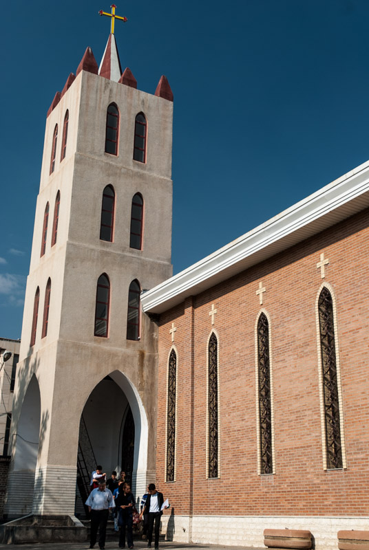
Saint Mary’s Church, Urmia, West Azerbaijan Province, Iran
Urmia is an ancient city which may date back to Urartian times, but it is historically notable for its Christian population. Although depleted by the spill-over of the Armenian and Assyrian genocides from Ottoman Turkey in 1914, the city remains something of a centre of Christianity with communities belonging to the Assyrian (Chaldean) Catholic Church, Assyrian Church of the East, Assyrian Protestant Church and Armenian Orthodox Church. I spend a very pleasant morning strolling around Urmia, visiting the various churches. At the Catholic St Mary’s Cathedral I speak the caretaker who is keen to show me around and explains that despite many Christians having left Iran following the Islamic Revolution of 1979, the Christian community is free to observe all festivals and to use alcohol; only the supply of alcohol to, or the conversion of Muslims is forbidden.
Nearby, the St Mary’s Church, belonging to the Assyrian Church of the East, claims to be one of the world’s oldest churches, having been founded by three Zoroastrian Magi (the Three Wise Men) following the birth of Christ, on the site of an older Zoroastrian temple. The church looks modern from the exterior and the interior, which includes a stone-walled grotto-like shrine with a statue of the Virgin Mary looks equally recently restored, making such grandiose claims rather hard to believe in. Here however I meet an Assyrian congregation following their Friday-morning gathering and speak to Ugin, the English-speaking son of a priest who tells me that his family speak Syriac at home and who is one of a population of approximately five thousand Assyrians in Urmia. It’s interesting to meet someone who is ethnically and linguistically a direct descendant of one of the world’s oldest civilisations.

Lake Urmia, West Azerbaijan Province, Iran
I leave Urmia in the afternoon and drive southward, past the tragic remains of Lake Urmia; desolate, white salt-flats as a backdrop to the agriculture which has caused the lake’s downfall by syphoning off water from the rivers that feed it. Beyond the southern edge of the former lake, the land rises as I climb towards the province of Kurdistan, dropping past the city of Saqqez where I camp for a night. As I drive deeper into Kurdistan the following day, the scenery becomes ever more rugged with craggy mountains, under which forests of chestnut and scrub-oak are dotted by donkey paths and occasional mud-topped footbridges over rushing torrents of mountain water. My final stop in Iran is the friendly city of Marivan, where Maciej and I had stayed for a night back in early February 2009 and which now, in late summer, seems far more inviting than the cold and slightly rough-feeling town I remember. I am hosted by Hiva, a local Kurd who immediately feels like an old friend and whose unseen mother prepares for us one delicious meal after another.

Landscape, near Penjween, Sulaymaniyah Governorate, Iraq
North-east of Marivan the road takes me past Lake Zeribar whose gleaming blue water backed by forested mountains almost gives it an air of Kashmir, and soon arrive at the Beshmaq border crossing. I pass through a throng of lorries, mostly transporting fuel, but after a short wait I’m stamped out of Iran with little fuss. The Iraqi side of the border is calm and very friendly and after paying a customs fee of around twenty US Dollars I’m on the road, thrilled to be in a new country and to finally be in Iraq, even if my entry stamp is only good for travel in areas administered by the Kurdistan Regional Government.
I’m driving through an area of beautiful rolling hills, now golden with dry grass but dotted with pine and oak trees. The road is in excellent condition and driving standards seem to be higher than in Iran. There are even men in high-visibility jackets collecting litter from the roadsides. I cross a low pass and enter a long, wide valley; a beautiful drive in the warm, late-afternoon light. I aim for the tell (settlement mound) of Bakr Awa which is one of hundreds which may be found in Iraq; millennia-old piles of the detritus of early human settlements, a reminder that one is in the cradle of civilisation. I try to camp near the tell but am moved on by locals, sighting security concerns, and so sleep in a ploughed field a few kilometres away, just out of sight of the nearby city of Halabja.
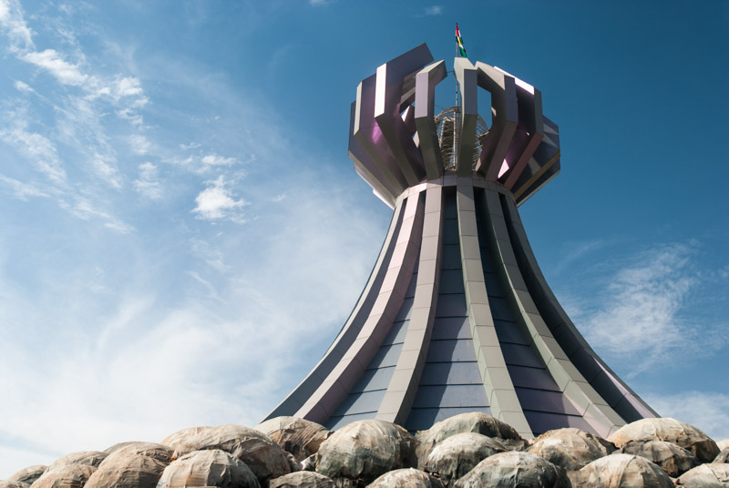
Halabja Memorial Monument, Halabja, Sulaymaniyah Governorate, Iraq
Halabja is a rather nondescript provincial city infamous for the 1988 Halabja Chemical Attack, which killed between 3200 and 5000 people and left many more injured. It is the most deadly chemical attack in history which targeted civilians. Carried out by Saddam Hussein and other members of his Ba’athist government during the last months of the Iran-Iraq War, the attack aimed to destroy Kurdish resistance against the Iraqi Army and was also part of the wider, genocidal Anfal Campaign, which aimed to ‘Arabise’ northern Iraq by eradicating Kurdish settlements.
I drive into Halabja in the morning and head straight to the Halabja Memorial Monument, a modern building in the shape of a gas plume from a chemical bomb, which houses a deeply moving museum complete with dioramas and photographs of the appalling scenes witnessed on the city’s streets on the 16th March 1988; scenes of whole families killed by gas, of lifeless, chemically-burned bodies; a city where life had been wiped out and time seemed to stand still. The attacks drew a muted international response at the time, as Western countries and especially the United States who were supporting Saddam in his fight against the Iranians, falsely blamed Iran for the atrocity.
There’s little else to see in Halabja and in the afternoon I make my way north again to the junction town of Said Saddiq, from where I turn west towards the regional capital, Sulaymaniyah.
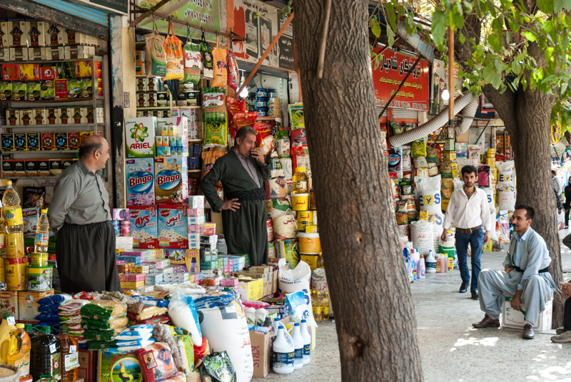
Bazaar, Sulaymaniyah, Sulaymaniyah Governorate, Iraq
Sulaymaniyah is a bustling city of bazaars; thoroughly modern and rapidly growing. It is my host Baderkhan however who makes my stay here truly memorable. Half Kurdish, half Arab, Baderkhan is one of the great-grandsons of Mahmud Barzanji, who led a number of uprisings against the British Mandate in Iraq and in 1922 pronounced himself King of the Kingdom of Kurdistan, based in Sulaymaniyah; the closest the Kurds have come to an independent state in recent history. I meet Baderkhan in his pharmacy shop and after a lunch of kebabs he shows me around the city’s thronging bazaars which, while lacking the ornate elegance of those in Iran, have every bit as diverse a collection of goods on sale. Money-changers sit at the street-side with many thousands of dollars of cash just placed on a low table. I see a local cinema which openly shows soft-porn. Alcohol is freely on sale and Baderkhan tells me it is customary to drive up into the hills above the city and drink in one’s car; though drink-driving is frowned upon on weekdays. Further up, couples engage in romantic trysts; all with no harassment from the police. Sulaymaniyah is clearly pretty liberal by regional standards and it’s a refreshing sense of freedom after the cloying religious-authoritarianism of Iran.
After exploring Sulaymaniyah’s bazaar, Baderkhan drives me around town in his brand new Toyota Landcruiser, and I glimpse the lives of the city’s liberal youth, who entertain themselves in bars and fast-food restaurants. I meet Shevan, a political science graduate who now works for the Kurdish security agency. Brought up in a secular family, he now claims to be Zoroastrian and is clearly pro-American. He tells me that the Americans have done a lot for the Iraqi Army, but that the Iraq’s failed to take advantage of their training. What’s the future for Iraq, I ask? “There is no solution for Iraq; the country will be at war forever”.

Khanaqah Mosque, Sulaymaniyah, Sulaymaniyah Governorate, Iraq
In the morning Baderkhan takes me to the infamous Amna Suraka (Red Prison) where Iraq’s secret security service, the Mukhabarat tortured and imprisoned members of the local population until it was stormed by Kurdish forces during the Gulf War in 1991. Outside the bullet-pocked building are tanks, armoured personnel carriers, artillery and trucks hastily abandoned by the Iraqi Army in 2003 when the Second Gulf War broke out. The prison is now a museum of the Anfal Campaign. After entering, we walk through the ‘Hall of Mirrors’; 4500 lights (representing the number of villages said to have been destroyed) illuminate 182,000 shards of broken mirror, which represent the death toll. I see that Baderkhan is visibly moved by this. Although he now lives a very comfortable life, his family were greatly affected by Anfal. Despite Baderkhan’s father being an Arab, the family decided to leave Baghdad in 1991 when the Americans invaded and came to Sulaymaniyah. When Saddam began to attack the Kurds he, his mother and sister were forced to flee across the mountains with thousands of others and lived in a refugee camp in Marivan, Iran. “I opened my eyes under a canvas tent” Baderkhan tells me, with damp eyes. Beyond the hall there are gruesome waxworks of prisoners undergoing torture, with the cells left as they were found in 1991. Finally there is an exhibition on Kurdish history and culture, including a life-size figure of Barzanji, Baderkhan’s great-grandfather, which he avoids making eye-contact with.
Sulaymaniyah’s archaeological museum contains tantalising artefacts of the Mesopotamian civilisations which were based south of the Zagros Mountains of Kurdistan; areas sadly beyond the limits allowed by my entry stamp. Amid various Sumerian tablets is an original bearing part of the Epic of Gilgamesh, perhaps the oldest surviving work of literature, written in cuneiform, an alphabet used for more than three thousand years in Mesopotamia. There are also Sumerian statues, Akkadian bronzes, ivory inlay-work from Nineveh and a balbal (menhir) from the Turkic-era. Seeing such artefacts whilst standing in Iraq only heightens my resolve to one day find a way to visit the south: ‘Real Iraq’.
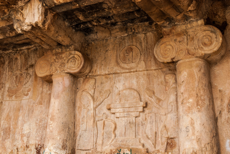
Qizqapan Tomb, Sulaymaniyah Governorate, Iraq
On my last day in Sulaymaniyah, Baderkhan drives me up into the hills to the east and north of the city, through rolling countryside which still appears somewhat depopulated; the legacy of Anfal. A road leads up a beautiful valley to a steep cliff-side where local legends describe a cave where a common man lived with the kidnapped daughter of a noble. Qizqapan is actually a sixth century BCE rock-hewn tomb whose facade depicts two men facing each other over what appears to be a fire altar. There are other flourishes of pre-Zoroastrian iconography including what looks very much like a depiction of the Mazdanic God, Ahuramazda as well as two carved ionic columns. Who exactly the figures are is not known but the larger figure may be the Medean King Cyaxares who turned the Medean Empire into a regional power at the expense of the Neo-Assyrian Empire; part of a transition of regional power from Mesopotamia to Persia which continued into the modern age.
After lunch at an Italian buffet, it is time to part ways with Baderkhan, who has spent most of the last three days escorting me around his home-town and making what would have otherwise been a fairly unremarkable city into an unforgettable experience. We part as friends with me vowing to return one day to see the South.
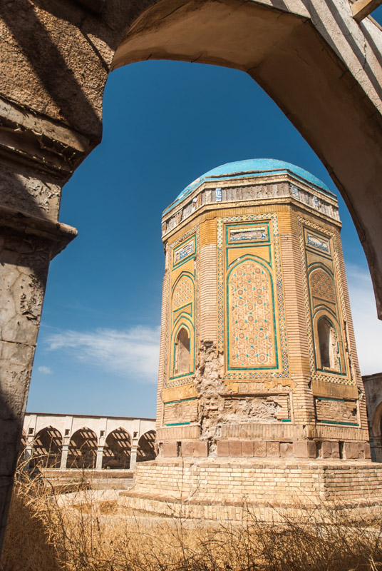
Buğday Khatun Mausoleum, Kirkuk, Kirkuk Governorate, Iraq
My next destination is the city of Kirkuk. Not technically part of Iraqi Kurdistan, I am only able to visit the city since its peaceful takeover by the Peshmerga in June of this year, though there is no guarantee that I will be allowed through the checkpoint on the road from Sulaymaniyah. Kirkuk is a multi-ethnic city with Kurds, Arabs and Iraqi Turkmens (descendants of Ottoman Turks, not Central Asian Turkmen) making up the majority of the population and all vying for supremacy in the city and oil-rich region which surrounds it. With a history of inter-ethnic violence and several bombings in recent years, Kirkuk is a place which Kurds in Sulaymaniyah have advised me to steer clear of, but having made contact with Arshed, a local Kurd who will host me for two days, I have decided to take advantage of what might be the only chance I get to see ‘Real Iraq’ for quite a few years.
It’s well after dark as I slip unnoticed through the checkpoint into Kirkuk Governorate and soon I see the lights of Kirkuk sprawling on the plains beyond. I meet Arshed on the busy main road and he escorts me into the winding city streets where he lives with his parents. His family are extremely welcoming and immediately ply me with food, eaten on the floor in traditional style. Outside, warm air masses from Mesopotamia clash with cool air from the Zagros and create a magnificent storm with an intensity which Arshed’s family have never seen. I have a sense of primal excitement; of breaking new ground into a region unknown to me and very rarely visited by other travellers.

Bazaar, Kirkuk, Kirkuk Governorate, Iraq
In the morning, Arshed takes me out to explore Kirkuk. We start in a Turkmen bakery eating kahi, syrup-soaked pastry and börek, meat-filled puff pastry while another violent storm turns the street outside into a torrent. Turkmen, Kurdish and Arab customers all patronise this obviously popular breakfast spot. Once the rain has subsided, we make our way to the city centre which is clustered around an ancient citadel. With chaotic traffic, pot-holed roads, long, frenetic bazaars and shocking amounts of litter on the streets and choking the foul-looking, reed-lined Khasa River, Kirkuk reminds me strongly of my old home in Hyderabad, Pakistan and seems a world away from the clean streets of Sulaymaniyah. I immediately like the place. We are joined by Arshed’s friend Mahmud and after a brief discussion with an initially reluctant security guard, we are allowed to freely wander around the citadel.

Vegetable Seller, Kirkuk, Kirkuk Governorate, Iraq
Kirkuk’s citadel is built on a tell thought to date from Assyrian times, and contains a number of intriguing buildings; a rather plain, twin-domed mausoleum attributed (not uniquely) to the Jewish prophet Daniel; the Ulu Camii with an ancient brick minaret, a Chaldean cathedral which has been comprehensively destroyed and a number of beautiful merchant’s houses which appear to have recently been restored, then left to decay once again. By far the most beautiful however is the squat, tower-like mausoleum of Buğday Khatun, a fifteenth century Aq Qoyunlu (Turkmen) princess; evidence of the long history of Iraq Turkmen who regard Kirkuk as their cultural capital. Arshed and Mahmud explain that under Saddam, the Citadel was deliberately destroyed in an attempt to ‘Arabise’ Kirkuk. As we finish our tour of the citadel at mid-day, we hear the city’s mosques come alive with the call to Friday prayer, followed by what sound like fiery sermons.
Kirkuk, Kirkuk Governorate, Iraq
In the evening we meet Arshed’s cousin Diyar and drive to the edge of the city to get a distant view of the oil-fields which make Kirkuk such a strategic prize in northern Iraq. Back in the city we visit the Rahimawa Bazaar, eat excellent falafel and then retire to a street-side sheesha bar for a smoke, watching the locals grill fish on charcoal braziers. Perhaps fifty metres from the cafe is a distinctive pattern of ballistic damage to the road surface; evidence of a recent bomb attack. A little further down the road is the site where Diyar’s brother was killed by a stray bullet when the US Army shot dead an old man driving a pickup who failed to stop at a checkpoint. I’m once again struck at what raw lives people live here in Iraq, the damage done by years of oppression and war which belies their great generosity and friendliness, and how I, thankfully, have no personal experience with which to compare it. Exactly three years after I reach Kirkuk, the city would be taken back by the Iraqi Army and many Kurds, including Arshed and Mahmud, would feel compelled to leave for their own safety.

Citadel, Erbil, Erbil Governorate, Iraq
As I leave Kirkuk I see signs for destinations in the south which I dream of visiting; Baghdad, Mosul, Tikrit, but all are off-limits – not to mention extremely dangerous – for a foreigner to visit. I drive north, back towards Iraqi Kurdistan proper, entering Erbil Governorate after considerable questioning from a suspicious soldier at the highway checkpoint. Erbil may well be one of the world’s oldest continuously inhabited cities and from afar its citadel, perched on a thirty-metre high tell which might be more than seven thousand years old, evokes some of the magic of Aleppo (my favourite city). On closer inspection however, it is but a shell with little of Aleppo’s charm, and the surrounding city is disappointingly bland and modern-looking. As well as being the seat of the KRG, Erbil is also the headquarters of the Assyrian Church of the East and in the district of Ankawa are two cathedrals, now tragically thronged by refugees displaced by ISIL from their homeland in the nearby Nineveh Plains. Nothing however really hints at the city’s great age, perhaps due to it having been a backwater of the Ottoman Empire for centuries, and after one day looking around I am ready to leave.

Rawanduz Canyon, Erbil Governorate, Iraq
From Erbil I head north-east, back towards the mountains on the British-made Hamilton Road which winds up to the Iranian frontier. I however stop in the town of Soran; a bland modern settlement whose population is mostly made up of returned Kurdish refugees whose mountain villages have been destroyed during Anfal. I’m hosted here by Oliver, an erudite British expatriate teaching in the local university; a cherished opportunity to speak at length with a native English speaker passionate about the region. I spend a day driving around the local area which is in places dramatically beautiful. Just below Soran a side-road climbs steeply into the rugged mountains with magnificent views over the Hamilton Road and up the narrow cleft of the Rawanduz River, which looks like small, grassy Arizonan canyon. Climbing further to the east, there are more beautiful mountain landscapes, but once again the legacy of Anfal is clear; there is an odd feeling of depopulation and any villages one does come across are modern and charmless, marred by the sight of blue plastic tarpaulins.

Assyrian Man, Amadiya, Duhok Governorate, Iraq
I leave Soran heading northward along a ridge of dramatically uplifted rock, turning westwards and crossing a low pass to drop to the valley of the Great Zab River, a major tributary of the Tigris. It’s a beautiful drive, following the wide, muddy river upstream until it turns northward into Turkey, to the rugged and restive mountains south of Hakkari through which I had passed almost three months earlier. I imagine the green and inviting mountains to the north of the river to be the base of Kurdish guerillas who occasionally prey on the Turkish military.
Shortly after leaving the Great Zab, I reach the striking town of Amadiya. Situated on a flat-topped mountain which juts from the surrounding valley, Amadiya must long have been settled and was part of Assyria in the third millennium BCE. In addition to its location, the town is also attractive in its own right, unlike the typically bland, modern settlements around it. With neither significant traffic nor squalor in its narrow, ancient streets, it’s an attractive place to stroll for an afternoon, amid a friendly population of Assyrians and Kurds.
In the evening I continue towards the regional capital of Duhok but turn south just before reaching the city on a road which will lead down to the Nineveh Plains around the troubled city of Mosul. I’m a touch nervous about entering this region as ISIL are currently advancing ever closer, but it might be the last chance to witness the region’s indigenous, non-Muslim communities. I camp at a low pass just above the road and spend an uneasy night punctuated by the eerie flickering of an unseen gas-flare, the distant thumping of artillery fire and the nearby calling of jackals.
Shrine of Sheikh Adi, Lalish, Nineveh Governorate, Iraq
After a somewhat uneasy night I descend through beautiful, spine-like ridges of craggy hills, the last undulations which precede the hazy plains of Nineveh and Mesopotamia. Up a scrubby side valley of olive trees I reach the village of Lalish; sacred to followers of the Yazidi faith and home to its holiest shrine; that of the hermit and saint, Sheikh Adi.
The Yazidis are a small ethnic group similar to but arguably distinct from the Kurds who follow a somewhat mysterious and often misunderstood monotheistic religion. Yazidis believe that an indifferent God created a barren and violent Earth and placed it under the care of seven holy beings or angels, chief of whom was Melek Taus, the Peacock Angel. The likeness of Melek Taus to Iblis or Satan in the Islamic tradition has long-fuelled incorrect, sensational and offensive claims that Yazidis are ‘Devil Worshippers’.

Yazidi Priest, Lalish, Nineveh Governorate, Iraq
For a people who are renowned for being secretive and strictly endogamous, and who have long been maligned and attacked by their neighbours, I am very warmly received in Lalish. After a brief talk with elders I am given an acolyte, Kovan, as a guide, and am told that I may visit all places and photograph whatever I wish. Pilgrims are milling around the shrine, some from the large Yazidi diaspora now resident in Europe (mostly Germany), others such as two Armenian-born Ukrainians who come from Yazidi communities in the Caucasus. Many however are refugees, whose camps line the road and surrounding hills; Yazidis from Sinjar who have been displaced by the savagery of ISIL from their homes around a holy mountain close to the Syrian border.
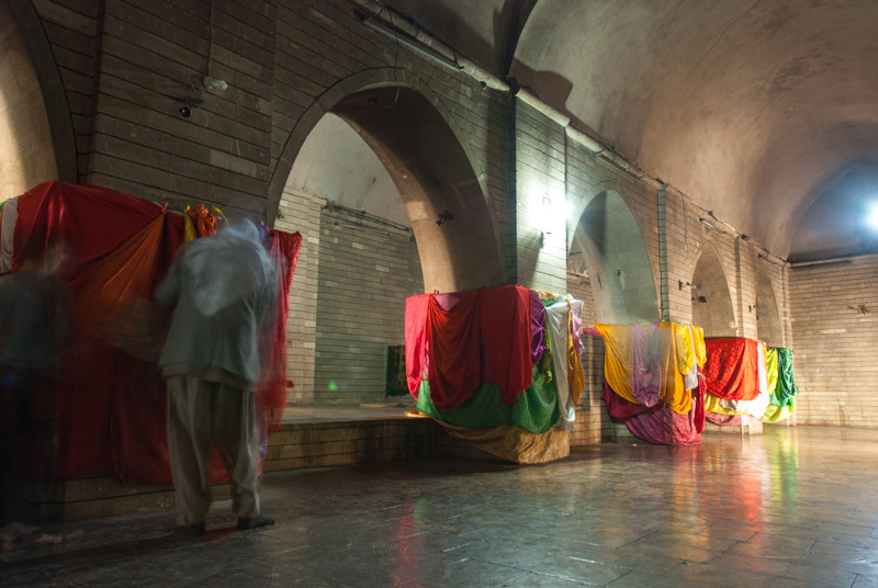
Kovan and I enter the shrine through a door with a richly carved pediment and relief of a large black serpent, and enter the sanctuary. Here are tombs said to belong to some of the seven Earthly Angels, and central columns are tied with various brightly coloured cloths – representing the colour brought to Earth by Melek Taus – in which pilgrims tie a votive knot, kiss it and touch it to their foreheads whilst saying a prayer. The room is filled with olive-oil lamps and I’m told that 366 wicks are burnt each day. Beyond the sanctuary is the plain grave of Sheikh Adi himself, an eleventh to twelfth century Sufi born in what is now Lebanon who is regarded by Yazidis to be the Earthly incarnation of Melek Taus, and whose grave pilgrims circumambulate in prayer. Elsewhere in the complex are tombs of other, lesser saints, the sacred warm spring of Zamzama, and a room containing ancient-looking amphorae filled with the locally produced olive oil used in the lamps.
Relief of King Sennacherib, Khanis, Nineveh Governorate, Iraq
I leave Lalish thankful for a fascinating glimpse of a people and religion previously unknown to me, but deeply troubled by the obvious peril which these people are currently facing. Descending further toward the plain, I enter the Assyrian heartland around Mosul and a region which is even closer to ISIL. Created by the chaos and power-vacuum brought to Iraq by the Americans and fuelled by their atrocities, ISIL have spread rapidly across the country in recent months and have unleashed unspeakable brutality against the non-Muslim communities of northern Iraq, effectively continuing policies long perpetrated by Saddam and the Ottomans during the twentieth century. With many Christian Assyrians having fled to Turkey and Europe I fear this could be a final opportunity to visit these ancient communities which are descended from one of the world’s oldest civilisations.
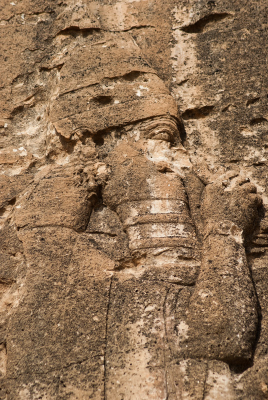
Just before dropping onto the plain, I take a track up to a point known as Khanis where the Gomel River emerges in a wide gorge from the mountains. This is the location of what might have been the world’s first aqueduct, built around the eighth century BCE in the Neo-Assyrian Empire to control the flow of water to cities such as Nineveh. Little remains today except for a damaged relief of King Sennacherib, the eighth-century BCE ruler of Assyria who oversaw the building of Nineveh and destruction of Babylon. Here, close to the edge of Mesopotamia is another taster of the riches of the South, but the sound of artillery fire last night are a clear reminder that now is not the time to visit.
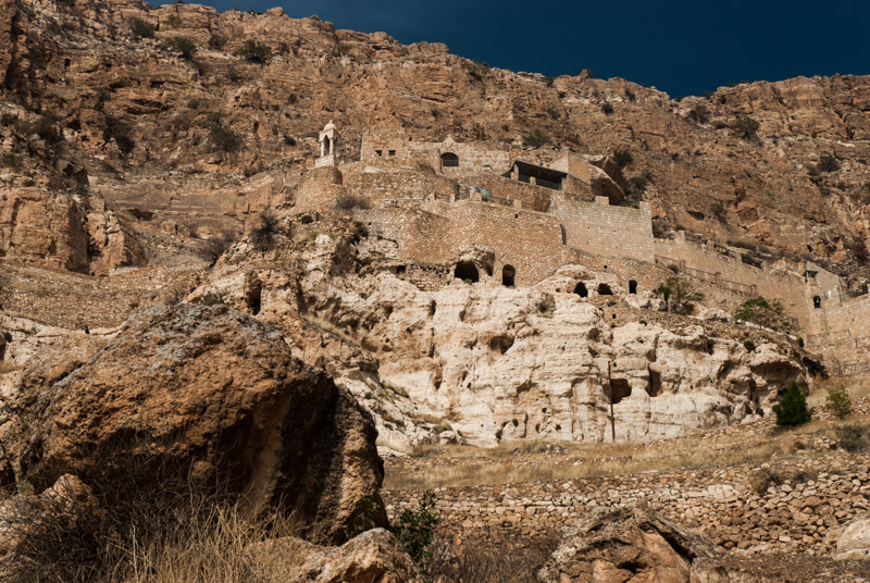
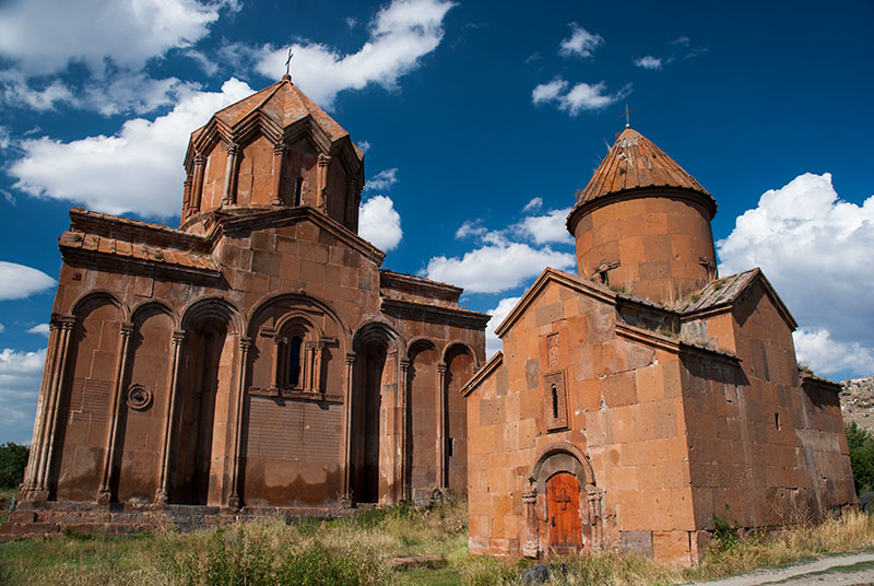
Rabban Hormizd Monastery, Alqosh, Nineveh Governorate, Iraq
Once on the plains, I’m initially concerned at how close the front-line might be; the situation is changing fast, but I estimate ISIL to be perhaps twenty kilometres away in the haze. I’m put at ease however once I see Turkish and Iranian lorries on the road. My final stop in Iraq is Alqosh, a town of Neo-Aramaic speaking Assyrians who follow the Chaldean Catholic Church, nestled at the foot of the mountains. Although Alqosh is under the control of the Peshmerga and Dwekh Nawsha, the Assyrian militia, ISIL came perilously close just two months ago, causing many of the town’s residents to flee. I make my way up into the hills above town, driving up a tight serpentine road to the seventh century Rabban Hormizd Monastery, a striking catholic hermitage which hangs from a mountainside and looks to be straight out of the Holy Lands. Although there are doors open and even lights left on, the monastery is eerily deserted and the narrow valley channels sounds in from the plain, making the distant artillery fire seem suddenly more urgent.
Alqosh, Nineveh Governorate, Iraq
Returning to the town, I have a brief walk around and find myself in a picturesque cemetery, filled with small, pavilion-like graves with Syriac inscriptions. There’s a nice view over an ancient-looking jumble of boxy, stone-walled homes which cluster around a large monastery. Here I meet Fazel and Sevan, two locals who after initially questioning my reasons for visiting, soon invite me in for tea and fruit. Although many of the town’s residents have fled, some are beginning to return and Fazel is confident that the Kurdish and Assyrian forces can hold on to the town. It’s startling to think that this community is poised on the very edge; staring into the plains at potential genocide.
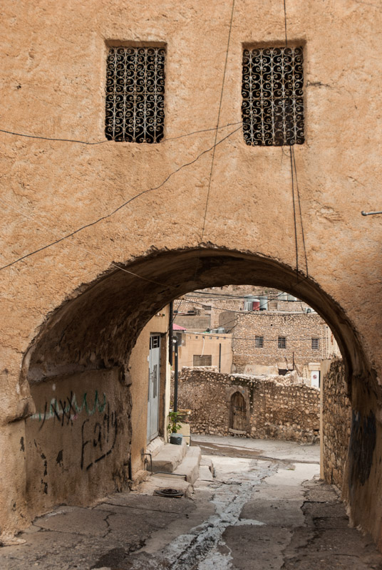
Alqosh’s old town consists of wandering, narrow streets running between beautiful stone houses; by far the nicest which I have seen so far in Iraq. There are ruins of an eight-hundred year-old synagogue of the Biblical prophet Nahum and indeed, with its Christian, Aramaic-speaking inhabitants, domed churches and occasional palm tree sprouting amongst the stone walls, Alqosh has to me a distinctly Biblical air about it. In better times Alqosh would be a wonderful place to linger, but the ongoing sounds of artillery fire persuade me to leave and make my way towards the Turkish border. Five kilometres beyond Alqosh I join the busy Mosul – Duhok Highway and breathe something of a sigh of relief. I can’t imagine what it must be like to live for months with such an imminent and nearby threat to one’s life, people and culture.
I bypass Duhok on an eight-lane motorway but get into a snarling bottleneck at Zakho, where I stop long enough just to change some money and fill up with diesel before entering Turkey. The formalities on the Iraqi side of the border are long and chaotic, mostly it seems due to my exiting from a different border crossing from that at which I had entered, and it’s well after dark by the time I approach Turkish Customs.
My trip across this region has far exceeded my expectations. I came to Iraqi Kurdistan imagining it to be much like Kurdish areas of Turkey and Iran; ruggedly beautiful but culturally bland. Instead I had an insight into a very ancient region on the fringes of Mesopotamia, glimpsed ancient cultures whose very history is being written by current events and heard first-hand accounts from the wonderful people of the region of their raw, often tragic recent history. I came expecting to bypass the historical gravitas of Mesopotamian Iraq, but realised that in this complex ethnic patchwork within the mountains and northern plains, I had very much seen the ‘Real Iraq’.
Stage 38 – Armenia & Nagorno Karabakh: The Lesser Caucasus [2/2]

Following a largely restive week in the Armenian capital, Yerevan, it required a little will-power to get back on the road, and continue this first visit of mine to the country. While I had enjoyed Armenia so far, I was beginning to tire of the numerous fine, medieval stone churches, and had no appetite to be among coachloads of European tourists. I wanted something a little more unconventional and adventurous.
I would find these qualities in the more rugged south of Armenia where (after a final clutch of magnificent churches), I would visit lonely Bronze Age petroglyphs and stunning lakes high in the mountains. More interesting still however, would be my two visits to the de facto independent Nagorno Karabakh Republic, de jure an occupied swathe of south-western Azerbaijan but with a once intricate ethnic make-up more complex than I had imagined prior to visiting. Here I would see both clear evidence of long-standing Armenian occupation (in yet more striking monasteries), but also sneak into areas which historically were clearly Azerbaijani; areas never part of the Soviet-era Nagorno Karabakh Autonomous Region, and whose towns and villages have been occupied and systematically destroyed by Armenian forces.
This rather sobering encounter with the long-standing conflict in the Lesser Caucasus was a clear demonstration of the deep-seated antagonism between the two communities, and would form one of my strongest impressions of the small country of Armenia, before making a final drive to the country’s southernmost tip, and crossing the Aras River back into Iran.

Garni Temple, Kotayk Province, Armenia
On the 22nd September 2014 I leave Yerevan after a very pleasant, week-long stay, and with somewhat limited enthusiasm drive east out of the city to the thirteenth century monastery of Geghard. Unlike any other Armenian monastery I have visited, Geghard is partly hewn out of the native cliff-face, and the quality of interior carving is breathtaking and to me hints at the pagan influence in Armenian Christianity. This however is tour-bus country, with elderly European tour groups, English-speaking hawkers and Russian tourists photographing each other. Armenian guides dole out their time-worn spiel, full of national pride, entrancing the diaspora Armenian tourists who relentlessly consume the culture of their ancestors. I’m just waiting for one of the guides to explain that Armenians invented fire.
Very nearby, and part of the same tourist trap is the similarly impressive Garni Temple; wholly Greco-Roman in design, though given an Armenian touch in being constructed from distinctive grey basalt. Garni, thought to date from the first century CE is the only intact Greco-Roman colonnaded structure in the Former USSR, though it was destroyed by an earthquake in the seventeenth century; what one sees today is a fine reconstruction completed during the Soviet-era. I like Garni for being different though, a refreshing encounter with a pre-Christian structure in Armenia.
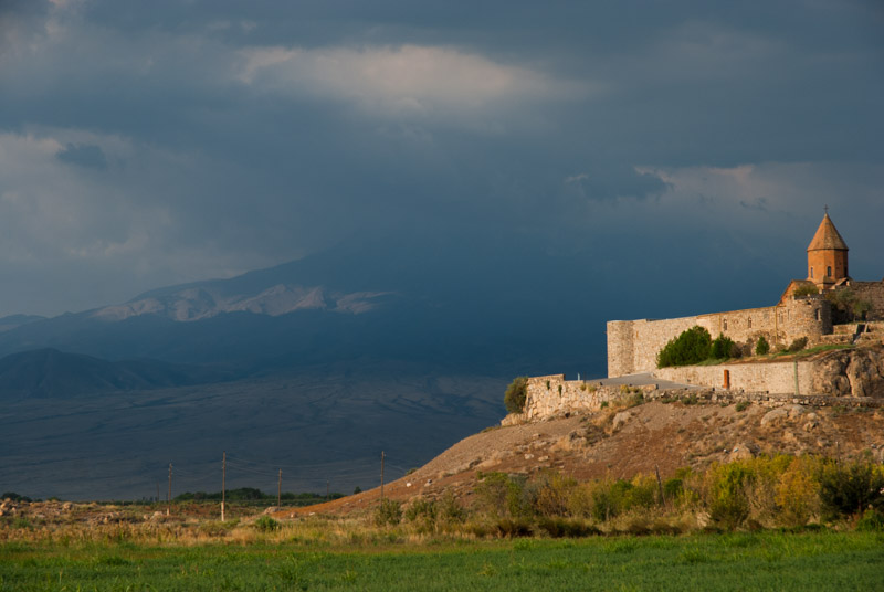
Khor Virap Monastery, Ararat Province, Armenia
It’s late afternoon when I leave Garni and I make the mistake of taking the old Yerevan ring-road, which leads through a foul, sprawling, informal rubbish dump covering a hillside beyond the eastern edge of the capital. Shortly beyond, the land has subsided so dramatically that the asphalt has broken up like pack ice; in places, islands of asphalt have totally detached from the road, and skeletons of old houses lean at impossible angles. I finally emerge somewhere near Masis onto the main Yerevan – Meghri Highway, which is being reconstructed and is heavily policed, despite the absence of any road signs. The area is heavily polluted with factories spewing smoke into the air (conveniently close to the Turkish border) and I am glad to turn off the highway after dark and stop for the night in a field just a few hundred metres short of the Aras River, which here marks the Turkish border. I enjoy a cold Kilikia beer in the truck as lightning flashes in the clouds above me. I am just below the seventeenth century monastery of Khor Virap, at the point which is as close as one can get to Mount Ararat – the national symbol of Armenia now – without leaving present-day Armenian soil.
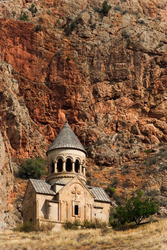
Noravank Monastery, Vayots Dzor Province, Armenia
In the morning the view is disappointing; clouds, haze and smog (from the Armenian side) mean that the huge mass of Mount Ararat sits almost invisibly across the frontier. I can’t bring myself to visit the monastery, and so resume my journey, almost as far as the border with Nakhchivan where I had been six weeks earlier. The road then leaves the Aras Valley and climbs towards the mountainous south of Armenia. Dropping into the Arpa Valley, I take a side road and climb up to Noravank Monastery. Despite having had my fill of churches I am genuinely impressed by those of Noravank which have perhaps the most dramatic location of any I have seen in Armenia, sitting below a sheer cliff of flaming red rock. The churches which make up the monastery are also highly notable, with the beautiful, fourteenth century Surb Astvatsatsin Church having an an unusual and intricate colonnaded tambour (drum) and the thirteenth century Surb Karapet Church having carvings of the Holy Mother with Child, and of God the Father, whose beard contains a small bird, and who holds the head of John the Baptist in hand, with a dove (the Holy Spirit) above it.
I proceed briefly further along the Yerevan – Meghri Highway, soon turning north towards Lake Sevan. I make another side trip to the village of Yeghegis, where there is an intriguing Jewish cemetery. Dating from the thirteenth to fourteenth centuries, very little is known of this Jewish community, and the thirty-odd gravestones, some covered in Hebrew or Aramaic script, were only uncovered in the last century.
Lake Sevan, near Martuni, Gegharkunik Province, Armenia
By late afternoon I am on top of the Varedenats Pass, where the landscape once again becomes beautiful, rolling steppe of yellow grass, and where one finds the beautiful black basalt Orbelian Caravanserai, a wonderful and complete relic of the Silk Road. Inside the highly atmospheric interior are two arcades of thick stone arches where one can imagine ancient merchants bedding down with their goods, the scene dimly lit by piercing ocular skylights with decorative stone carvings.
Not far from the crest of the pass, the beautiful sapphire-blue of Lake Sevan comes into view again, perhaps my favourite sight in Armenia, and I find a nice place to camp at the lake shore with beautiful views, only slightly spoiled by the great quantities of litter left by local tourists. I look forward to the day when people who regard themselves as highly civilised can refrain from fouling their own surroundings.

Levonaget Canyon, Shahumiyan Region, Nagorno Karabakh
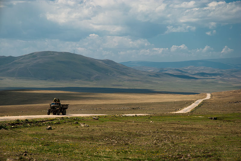
The following morning I drive around the southern edge of Lake Sevan, amid wide, open farmland, backed to the south and east by mountains. I stop on a pebbly beach on the eastern edge of the lake and watch a squall come in from the now steely-blue waters, blowing leaves off the poplar trees growing on the lake shore, a sure sign of the approach of autumn. After stocking up on food and fuel in the town of Vardenis, which has something of a frontier atmosphere, I climb eastwards on a surprisingly good road towards the Sotk Pass, which marks the border of the Nagorno Karabakh Republic. When applying for my visa back in Yerevan, I had been told that it was forbidden to enter ‘The Republic’ (which is internationally unrecognised, even by Armenia) via the Sotk Pass, but I wish to try regardless. After crossing the pass, which overlooks a huge slope of rubble generated by the Sotk Gold Mine, I descend into the forested hills of Nagorno Karabakh, a dramatic change in environment from the treeless, volcanic steppe around Lake Sevan. At a check post in the Levonaget Valley I’m waved straight through and soon after turn off the road and begin climbing up the Tartar Valley, towards the town of Karvachar (Kalbajar in Azerbaijani).
Nagorno Karabakh has a convoluted and contentious history of control between Armenians (who were undoubtedly first on the scene) and Muslims, the latter becoming vassals of the Persian Empire and progenitors of modern Azerbaijan. Control switched from Persian to Russian Empires in 1820, but a century later, as the Russian Empire descended into civil war, Armenians and the newly formed Azerbaijan Soviet Socialist Republic were at war over control of Nagorno Karabakh. With Soviet control, the conflict froze, and Stalin’s vile gerrymandering of national borders within the USSR saw the creation of the Nagorno Karabakh Autonomous Region as an enclave within Azerbaijan. With glasnost in the late 1980s came a softening of the iron fist of the Soviet State and the re-emergence of suppressed nationalism, and as the Soviet Union collapsed, the Nagorno Karabakh War broke out, raging on until a cease fire in 1994. The current status quo sees most of the Soviet-era Nagorno Karabakh Autonomous Region under Armenian control, together with a roughly similarly-sized area of Azerbaijan which adjoins the Armenian and Iranian borders, linking much of the former enclave to Armenia as the de facto Nagorno Karabakh Republic.
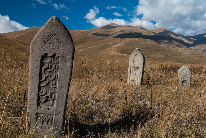
Azerbaijani Cemetery, Tsar, Shahumiyan Region, Nagorno Karabakh
This north-western part of Nagorno Karabakh is one such area of occupied Azerbaijan, and after passing the half-abandoned town of Karvachar and climbing further up the valley, I frequently see the remains of houses and small villages; the population of the area has clearly been drastically and deliberately reduced. I camp for the night near some abandoned buildings, sticking to existing vehicle tracks and not straying far from the truck in fear of landmines, though some local cows come plodding through the area in the morning, indicating that the area is most likely not mined. Climbing further, past a sulphurous fumarole, I pass a dramatic cliff of basalt columns covered in striking orange lichen, then climb on steep, narrow switchbacks to the cliff-top village of Tsar. Dozens of destroyed buildings are spread across the hillside – this must once have been a sizeable place – but today just a few buildings remain inhabited. When I ask, locals confirm that Azerbaijanis used to live here. There’s a barrier at the end of the village, but after speaking with some locals, my passport details are recorded and I’m free to proceed. My aim is to follow faint paths which I have seen on satellite maps, to the high altitude Al Lakes, then drive over the mountains back into Armenia.

Little Al Lake, Shahumiyan Region, Nagorno Karabakh
As I leave the village, I see an old Azerbaijani cemetery on the grassy hills; tall stones beautifully carved with Arabic script against a stunning mountainous backdrop, which although wonderfully tranquil is equally tragic given that the community has long since fled. The track I’m on is very seldom used – little more that flattened grass – and the only vehicles I see are a group of Soviet ZiL trucks which men are filling with cut grass, in preparation for the impeding winter. After some steep climbing I reach a wide, rolling plateau at an altitude of around 2700 metres, and just over two hours after leaving Tsar I catch the first glimpse of the magnificent Al Lakes; first Little Al then Big Al Lake, with a backdrop of the volcanic highlands on the Armenian border, below which is a dark, hardened lava flow reaching to the far shore of the lakes. It’s a magnificent spot, with just a few shepherds in Soviet UAZ vans and a camp of grass-cutters in an otherwise untouched wilderness. There are no signs of any tourists or their litter, and I have the satisfaction to have visited a truly remote area which I have never read anything about, but which has merely caught my eye when perusing satellite imagery of the region.

Ughtasar Petroglyphs, Syunik Province, Armenia
Surveying the landscape, I see a likely-looking route over the mountains back into Armenia. Initially, I follow some very faint tracks, then must drive cautiously over the soft hills of yellow grass, crossing a small but deep and rocky stream (in which I bash the front axle of the truck) and descending on rough tracks strewn with volcanic boulders until I run into some shepherds on the Armenian side. After confirming that I am on a good path, I descend to the resort town of Jermuk, set amidst beautiful deciduous forest pocked by the first brilliant yellow and orange flashes of autumn but marred by an ugly concrete monstrosity of a Soviet hotel.
Next day, from further east along the main highway, I climb into the mountains once again, back towards the border with Nagorno Karabakh. I take a wrong turn early on, and spend a couple of hours driving aimlessly across steep hillsides, but after considerable frustration retrace my steps and find the correct path, climbing steeply towards the prominent Ughtasar Mountains. After one unnervingly steep ascent on a loose gravelly track, with hair-raising drop-offs on either side, I reach the Ughtasar Petroglyphs at 3300 metres above sea level, which once again I can savour in complete, glorious solitude. The petroglyphs are well worth the trouble taken to reach them; over a wide area, on large, smooth, naturally varnished volcanic rocks are hundreds of pictograms thought to span thousands of years. Many are of long-horned goats, but there also human figures hunting on horseback with bow and arrow, and a beautiful twin ox-plough. There are also more esoteric geometrical patterns and what may be shamanistic symbols, once again impressing me what seems to be a running theme in Bronze Age rock art spanning much of Eurasia.

Zorats Karer, Syunik Province, Armenia
I spend the night back down near the main road and the following day take in another Bronze Age site known as Zorats Karer. This however is a large complex of standing stones; some arranged in a circle, some extending in linear arms, and some toppled or seemingly randomly located. There are speculations (spurred perhaps by Armenian national pride) that this is a very ancient observatory, which don’t believe in; to me the site resembles a large burial complex, particularly given the presence of numerous cists (slab-sided burial chambers) which can be found across Eurasia, through Kazakhstan and the Altai Mountains to Mongolia. Nevertheless, it’s an impressive and thought-provoking site and I wonder if its proximity to the nearby petroglyphs of Ughtasar is pure chance, or whether there was some ritual significance connecting the two sites.

Armenian Man, Stepanakert, Nagorno Karabakh
After a side trip to the impressively located, fortified Tatev Monastery, which overlooks the yawning Vorotan Valley, I return to Nagorno Karabakh, using the ‘official’ border crossing at Aghavno. The road is in near perfect condition, far better than any other I have seen in Armenia, and leads through the Lachin Corridor, another swathe of occupied Azerbaijan, crossing successive ridges and pleasant small towns and villages, before climbing into Nagorno Karabakh proper. Just after sunset I reach the capital, Stepanakert, and I meet my local contact Marut, who helps me find a homestay run by a very kind Armenian family who ply guests with excellent food and endless coffee and sweets.
I walk around Stepanakert with Marut the following day, and find it to be a likeable place; while there are still the odd signs of war, such as bullet-holed apartment buildings and fresh war cemeteries, it is largely unremarkable, with a peaceful, pleasant and safe small-town atmosphere. The town is not unlike others across the border in Armenia, if a touch more Russified, perhaps from having had a large Soviet Army presence, or for once having had a mixed Armenian and Azerbaijani population with Russian as the lingua franca. I very much enjoy the homestay, where I am joined by Will, a British photographer and Ace, the Filipino nurse with whom I had made friends back in Yerevan. One night I am awoken by an odd shaking of my bed, which I initially assume to be from a passing lorry, but soon realise is an earthquake, which turns out to be of magnitude 5.3, located 190 kilometres away in Azerbaijan proper.
Lower Govhar Agha Mosque, Shushi, Shushi Region, Nagorno Karabakh
Close to Stepanakert is Shushi, which in contrast feels quite tragic. Clearly once an elegant city and cultural centre, Shushi calls to mind war, dereliction, ethnic cleansing and poverty. Among many abandoned and bombarded buildings, two once beautiful mosques, the Upper and Lower Govhar Agha, stand with sentinel minarets of beautiful, red and buff brickwork, poking above the straggling ruins of various other civic and civilian buildings. Neither are of course active, and the balconies of the minarets of the latter seem now to be used only by idle teenagers. There can be almost no prospect for employment in Shushi, and it seems that much of the population is elderly and penniless. Clearly once a beautiful place, I wonder what these old folk think of the age-old conflict, and whether they were really part of it, or just swept-up in the politics of inter-ethnic hatred. One moustachioed old lady rants madly at me as I take pictures of the minarets. Two roguish old drinkers cheerfully ask me for some money for a bottle. Sitting in a pavement bar a little later on, an old man confirms that this was once a beautiful city, then draws my attention to an Arabic inscription outside one of the mosques, and tries to convince me that it is French.
The church of course, has plenty of cash, and Shushi’s Ghazanchetsots Cathedral, recently restored, is one of the largest Armenian churches in the world, here totally at odds with the city’s appearance. On the street outside, a very well turned-out, perfumed priest steps out of a brand-new, black Landcruiser. How he, a man of faith supposedly living a pious life can do so seems to embody the parasitic decadence of organised religion, and the false legitimacy of the clergy. It’s ironic that while Lenin and Stalin helped set up the tragedy which befell Nagorno Karabakh upon the collapse of the USSR, they were never actually able to rid people of the clergy.

Gandzasar Monastery, Martakert Region, Nagorno Karabakh
It once again takes some effort to leave the homestay and new friends in Stepanakert, but I am excited to break away from the capital region and head east towards the front line, to areas of the republic which I had been told by the lady who issued my visa in Yerevan were ‘not open to tourists’. I drive out of Stepanakert on what would once have been the road to Baku, soon reaching the town of Askeran where the road passes straight through the breached walls of the Askeran Fortress, built by the Muslim rulers of the Karabakh Khanate during the Russo-Persian Wars of the early nineteenth century. Backtracking very briefly, I pass through the small town of Ivanyan, better known by its Azerbaijani name of Khojali and infamous for the massacre of two hundred or more Azerbaijani civilians by Armenian (and CIS) forces in 1992. Today it’s a sleepy place, but a Muslim cemetery on the edge of town (next to what seems to be an army artillery range) stands in testament to its former inhabitants.

Sarsang Reservoir, Martakert Region, Nagorno Karabakh
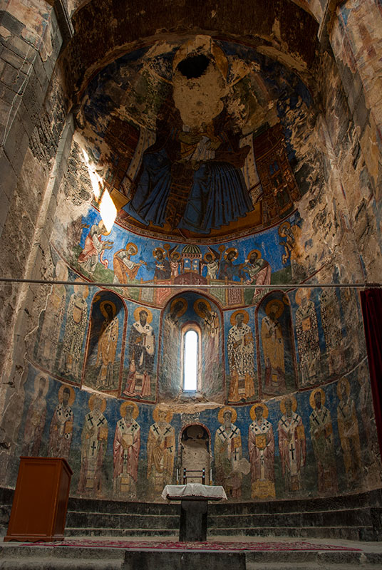
I wind north through muddy but picturesque countryside and slowly make my way to Gandzasar Monastery, whose thirteenth century Cathedral of St John the Baptist is the finest church I see in Nagorno Karabakh and the seat of the Archbishop of the republic. With a large, beautifully carved gavit (narthex) and faceted dome on zigzagging gables, located on top of a hill, it is unmistakably Armenian and a clear demonstration of the long-standing Armenian presence in this fractious mountain land.
I cross another range of mountains north of Gandzasar, descending to the edge of the inky-blue Sarsang Reservoir, in the Tartar Valley which I had climbed out of days earlier towards Tsar and the Armenian border. I drive on the rough valley road west to see Dadivank Monastery, nestled picturesquely in deciduous forest on the mountainside. Thought to date from the ninth century, Dadivank is more Byzantine in style than other Armenian churches I have seen, with large stone walls, a terracotta-roofed chapel and thirteenth century frescoes, and is in the process of being restored following apparent damage from now-departed Azerbaijanis.

Front Line, Martakert Region, Nagorno Karabakh
I spend the night in the hills above Sarsang Reservoir, listening to the howling of wolves, then drive in the morning through tranquil beech forest towards the front line. Martakert, the regional capital is a town which bears the scars of heavy warfare, with destroyed buildings and chewed-up roads, and is a rather ramshackle, unattractive place. From this point onwards, I suspect myself to be in a restricted area without permission, and imagine I will be ejected from the republic or arrested for being here, so I intend to keep as low a profile as possible (which in a foreign-plated, military-beige coloured vehicle is probably not very low).
I have to ask directions to find the only road heading south out of Martakert, such is the state of the city, but very soon I’m rolling down onto the plains on a road which parallels the front line at a distance of a few kilometres. Off to the east, the land recedes from the hills of Nagorno Karabakh into Azerbaijan proper, spreading in a hazy flatness towards the Caspian Sea. There’s a swathe of cultivated land along the roadside, out of range of Azerbaijani snipers, and then the trenches of the front line, looking not unlike the Somme, where soldiers have faced each other in a twenty year-old cease-fire, occasionally picking each other off. Beyond that, out of the reach of Armenian bullets, the land reverts to the rich, irrigated fields of southern Azerbaijan and, on the horizon, I can see neat, whitewashed Azerbaijani villages. It’s something of an illicit thrill to drive here.
Ağdam, Askeran Region, Nagorno Karabakh
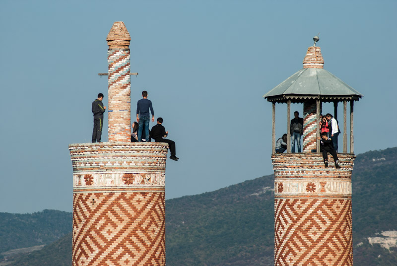
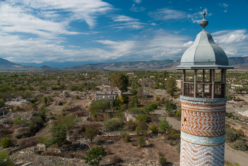
Heading steadily south, I pass a few ruins; a collapsing memorial to the Great Patriotic War (there seems some rather idiotic irony to a memorial dedicated to an earlier war damaged and neglected due to a subsequent war), an octagonal Muslim tomb and wrecked vehicles, and then Shahbulag Castle, an eighteenth century stronghold also built by the Khans of Karabakh. The road then reaches an intersection; the asphalt veers to the right, back towards Askeran and Stepanakert, but I continue straight to the destroyed city of Ağdam. I am worried to pass a rambling army base just north of the former city, but all I get is friendly waves from bored-looking conscripts and so I continue, bearing for the twin minarets of Ağdam’s nineteenth century mosque, built by the same architect as the two Govhar Agha Mosques in Shushi. I climb the eastern minaret to the upper balcony where once the muezzin would have called the azan. I’m surrounded by quite a moving scene; an entire city systematically destroyed, building-by-building, leaving only piles of rubble, disconnected patches of asphalt and mature trees gradually taking over the old city layout. All the colour of life has left the city – aside from the red, buff and blue of the minaret’s tilework – leaving a doleful monochrome. A plaque outside the mosque simply names it a ‘Persian Mosque’.

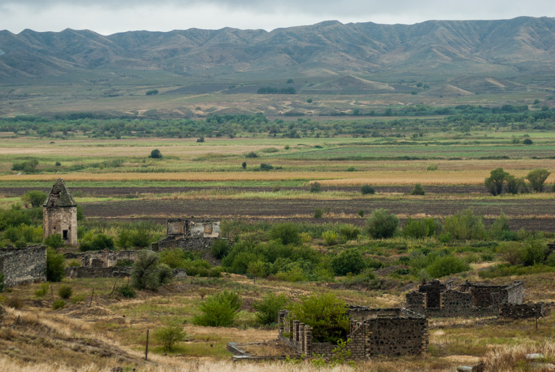
Amaras Monastery, Martuni Region, Nagorno Karabakh
Two gruffly friendly men join me at the top of the minaret and ask me what I’m doing, perhaps checking if I’m a journalist, but their suspicions seem soon to be allayed and conversation switches to the truck, and how much it’s worth, and if I fancy selling it. A few of the soldiers are milling around the ruins, but none approaches me. Nevertheless, I don’t stay too long. I find the road south out of town, which passes under a disused bridge for the old Stepanakert – Yevlakh railway, now devoid of rails or sleepers, and a number of other destroyed, presumably Azerbaijani villages. The road turns south east, still tracking the front line, but here there are no ploughed fields to my west, just a wasteland of tracks and destruction. Life returns at the Armenian town of Martuni, which is slightly less shabby than Martakert, but worried that I’ll be apprehended, I push on. I take a turn off the road, west into the foothills, passing through the picturesquely situated mountain town of Chartar which has an excellent new road, and is the liveliest place I have seen since leaving Stepanakert. It reminds me of an Iranian mountain town and makes me think how wonderful a place Nagorno Karabakh might have been, but for the war. I don’t stay long on the main road, but turn south again through villages to reach Amaras Monastery, located on the edge of the hills, overlooking the troubled plains.
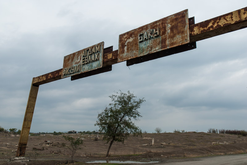
Füzuli, Hadrut Region, Nagorno Karabakh
Amaras is unprepossessing to look at, but has quite some history; said to have been founded originally in the fourth century by St Gregory the Illuminator, patron saint of the Armenian Apostolic Church. It is also said that Mesrop Mashtots established the first school to use his Armenian alphabet in Amaras. The monastery came to be abandoned and by the early eighteenth century was used as a Russian frontier post, and I assume that the formidable stone defensive walls date from this period. The monastery was reclaimed by the Church in the middle of the nineteenth century and the monastery’s sole church dates from this period, its walls now pocked with bullet marks from the recent war. I speak to a gentleman living in a home atop the monastery walls, who offers me lunch and points the way to what used to be the town of Füzuli, across the rolling fields, which he reassures me are free of land mines. It’s a nice drive across the fields, aside from the sight of yet more destroyed villages, but Füzuli has suffered the same fate as Ağdam; scorched earth and rubble, with even the cemetery appearing vandalised, the city unpopulated apart from the odd squatter or shepherd. On the southern edge of town I find a rusted gantry across the road with Soviet-era road signs, which I find highly poignant, for the destinations – Baku, Yevlakh, Ağdam, Füzuli – are either in unreachable Azerbaijan, or literally wiped off the map.

Aras Valley Road, Hadrut Region, Nagorno Karabakh
South of Füzuli, I reach an intersection where two traffic police sit in a Russian UAZ, but they pay no attention to me as I continue south towards the Iranian border. The road becomes rough as I start to climb gently into barren rolling khaki hills, and rain starts to fall gently. From Füzuli onwards, all is destroyed; systematically, house-by-house, save for the remains of old bus stops with their bright Soviet-era mosaics showing Azerbaijani folk dancers, and the occasional crumbling and pock-marked war memorial. This was very clearly part of Azerbaijan. Reaching the ruined town of Cäbrayıl, the road becomes an abandoned dual-carriageway partly overgrown with grass, and runs down to the Aras Valley and the ruined junction town of Şükürbäyli. From here, the road parallels the Aras Valley and the hills of Iran are visible to the south, shrouded in low, grey cloud. It’s getting late, and so I pull off the highway, drive through a muddy field where some farmers are just heading for home in a tractor, and camp in a clearing, hidden from the road and just a few hundred metres from the river. Even for someone who enjoys solitude and a sense of distance from crowds and cities, I feel extremely isolated and as I cook dinner and write down my impressions for the day, I watch the lights of the border posts and cars driving on the far side of the river, in Iran, where life goes on as normal.
Mämmädbayli, Kashatagh Region, Nagorno Karabakh
In the morning, after some difficulty in getting the truck out of my muddy camping spot, I continue westwards and reach the destroyed town of Soltanlı; again, razed completely to the ground. I spot a crude, concrete Armenian chapel on the road out of town, with icons and candles for passing Christians, which I find almost vulgar for its false piety in this land of vicious destruction, coming from a most unchristian, visceral hatred of another race.
In the dull autumn rain, the bleakness of the landscape and utter desolation make for an almost eerie drive along the Aras Valley, as there is absolutely nobody around; not a single car on the road, no shepherd or soldier. This land has simply been taken from Azerbaijan as a buffer zone, and left to decay. But as much as I find the circumstances utterly repellent, at the same time I must admit to getting a certain thrill from being the only person in an entire landscape, effectively driving along my own road. The Akari River, a tributary of the Aras, marks a suddenly lush, green swathe of land, and here I must take a slight diversion northwards owing to a broken bridge, driving on a smaller road which weaves through the rubble and detritus of more razed villages. One such village is Mämmädbayli with the octagonal, conical-roofed, fourteenth century Mausoleum of Yahya ibn Muhammad al-Haj finally drawing the eye to something other than destruction, and harking back to a more civilised time when this was braid of the Silk Road.
Zangezur Mountains, Syunik Province, Armenia
Across the Akari, an Armenian population begins to slowly reappear and the land comes falteringly back to life. It’s late morning by the time I reach the town of Mijnavan (Minjavan), with a beautiful main street of mature plane trees masking the squalor and dereliction of the buildings behind. I could return to Armenia along the Aras Valley, heading straight towards Meghri and the Iranian border crossing, but chose to head north, through the ruins of Kovsakan (Zangilan) and along a valley of misty limestone cliffs. I cross back into Armenia at a point near a rubbish dump which is wholly undemarcated, and without any official presence, and slip back onto the Yerevan – Meghri Highway in the town of Syunik, as if I had never been nosing around in the forbidden frontier of Nagorno Karabakh. I stop in the damp and rather dour mountain town of Kapan to eat and change some money, then continue south through filthy mining towns and on through the beautifully forested Zangezur Mountains, which are just starting to turn to autumn colour. The road is slow, choked with Iranian trucks bringing goods into this isolated mountain country and badly driven Iranian cars weaving in and out amongst them, but it’s also highly scenic and I’m content at having seen a good swathe of Nagorno Karabakh without getting into trouble.

The Last Judgement, Holy Mother of God Church, Meghri, Syunik Province, Armenia
Meghri is the final Armenian town and is more attractive than Kapan, and the following morning I make a visit to one final Armenian church, the fifteenth century Mother of God Church which is highly distinctive, if slightly graceless from the exterior. Inside are beautiful nineteenth century murals, including a magnificent scene of the Last Judgement, with vivid depictions of the demons of hell; unlike anything else I have seen in Armenia, though not unlike those of Vank Cathedral in the Armenian district of Esfahan, Iran.
Just beyond Meghri, I’m back in the Aras Valley, directly above the river on a road running along the old Soviet border, which still has an impressive amount of barbed wire separating it from the rocky riverbank. After rather lengthy customs procedures at the Agarak crossing, involving paying yet more fees to the Armenian Customs Office, I cross the Aras and am ready to begin the next stage of the Odyssey, to Kurdistan and Northern Iraq.
I’ve greatly enjoyed my time in Armenia, exploring the modern-day heartland of an ancient people with a breathtaking richness of culture; a people whose history has often been tragic, and who have been chased into an isolated and poor mountain heartland. It has also given me a chance to see for myself the reality of Nagorno Karabakh, one which has slightly changed my opinions. Previously, I had imagined that Nagorno Karabakh was ethnically Armenian, and wrongly ceded by Stalin to Azerbaijan (with the likely intention of fomenting ethnic rivalries). The reality however is more complex; there is clear history of a long-standing Muslim presence in the region; not just on the plains, but in amongst the church-dotted highlands. I can also sympathise more with the Azerbaijani cause, for areas which seem to me to have been undeniably part of Azerbaijan have been occupied, their inhabitants chased out or worse, and all their settlements deliberately destroyed to complicate any possible return. It’s all rather tragic for, in my imagination, Nagorno Karabakh could be a fascinating cultural melting pot and an enthralling destination to freely visit. But such is the reality in the Caucasus; this complex, feuding patchwork of nations and religions, where ethnic strife is far from a modern introduction.
In this second lengthy visit to the region, I feel a sense of completion, having visited every republic both north and south of the great mountain divide. At the same time, I am sure that I will return again.
Stage 38 – Armenia & Nagorno Karabakh: The Lesser Caucasus [1/2]

Through no deliberate design, the small, mountainous country of Armenia was the only of the Soviet Union’s fifteen component republics which I had not visited on my initial four and a half year journey. I had occasionally come across Armenian culture, usually in the form of distinctive stone churches in Iran or Turkey (and also in Syria and Israel on an earlier trip in 2006) and had even peered over into Armenia (then a wholly unknown country to me) from the ruined city of Ani in 2003, on my first trip across Asia. The country itself however remained a small blank in the map which I was keen to fill.
It was therefore with considerable anticipation that I approached Armenia, which would be the first time on this second part of the Odyssey that I would visit a country which was wholly new to me. As I drove around both Armenia and the de facto independent state of Nagorno Karabakh, I would find a landscape of mostly severe volcanic plains, quite different from the lush, bountiful, exotically beautiful valleys of Georgia, but rich with the distinctively beautiful forms of Armenian medieval church architecture. The Armenian people would also stand out, proud of their long though recently rather tragic history, dignified and deeply welcoming despite the obvious poverty which their isolated republic has fallen into since the collapse of the Soviet Union.
This first half of my journey through the Lesser Caucasus would take me on a meandering route through the north of Armenia, crossing the church-dotted centre of the Armenian Highlands, through the valleys of the far north-east and down to beautiful Lake Sevan, then across the volcanic Geghama Mountains and up Mount Aragats, modern Armenia’s highest peak. Heading south from here I would enter the real heartland of the country, the Ararat Plain, stretching along the Aras River where distant Mount Ararat hangs beyond the border in the haze above both the city of Vagharshapat, seat of the Armenian Apostolic Church, and the nearby modern capital Yerevan where I would break my journey.
Landcsape, near Musayelyan, Shirak Province, Armenia
I enter Armenia on the 4th September 2014, crossing from Georgia at the village of Gogavan late in the afternoon and soon pulling off the road to camp in a field, watching a storm descend from the mountains off to the east. After at least eight years of having the intention to visit Armenia, I am here, and the view in front of me is much as I had imagined to country to look, based mostly upon my first glimpse from across the Turkish border more than eleven years ago; attractive, rolling steppe and soft, low mountains which now fade into the dark, back-lit storm clouds.
In the morning, after a few errands in the small town of Tashir, I head east across the rolling upland which I had looked out upon last night, crossing a low pass and slowly descending past isolated villages of pink tuff houses, crossing the main road to Gyumri and joining the Akhurian River which here runs parallel to the Turkish border. Driving south on rough, decayed Soviet-era roads I eventually reach the beautiful Marmashen Monastery, on a grassy riverbank of the Akhurian, surrounded by fruit trees. Built of orange tuff, the monastery is centred on the beautiful eleventh century Katoghike (Holy Mother of God) Church, with a characteristically Armenian faceted umbrella roof, and tall niches on its external walls; contemporaneous with the churches of Ani but in far better condition; particularly pleasing to see given the neglected state of Ani’s buildings.
Marmashen Monastery, Shirak Province, Armenia
From the monastery it’s a very short drive south to reach the rubble-strewn northern suburbs of Gyumri, Armenia’s second city, where I pass a mixture of bulldozed city blocks, abandoned, half-built apartment buildings and various barracks making up a large Russian military presence, with each of these being symbolic of Armenia’s turbulent recent history.
The 1988 Spitak Earthquake had its epicentre just thirty five kilometres from Gyumri, killed between twenty five and fifty thousand people and came at a time when Gorbachev’s reform in the Soviet Union had lead to a greater expression of nationalism. This freedom however also allowed simmering ethnic conflicts to erupt, which in the South Caucasus republics lead to an outburst of repressed tension and conflict between Armenians and Azerbaijanis in both republics. Internally displaced people had arrived in Armenia at the time of the earthquake, which in addition to the low-quality Brezhnev-era apartment blocks caused a huge death toll from the magnitude seven earthquake.

Gyumri, Shirak Province, Armenia
The collapse of the Soviet Union in 1991 spelled economic chaos for Armenia (and indeed every part of the Former USSR), but was accompanied by the outbreak of full-blown conflict in the Nagorno Karabakh War, which raged until 1993 and saw Armenia and Azerbaijan fighting over the historically Armenian region of Nagorno Karabakh, which was ceded by Stalin to Azerbaijan in 1928. The conflict, in a wider sense, can be seen as part of Russia’s age-old antagonism with the Turks and, with Russia siding with Armenia, gave ample opportunity for Russia to retain a large military presence in this lost territory, strengthening its very sensitive former border with NATO and retaining a toe-hold in the South Caucasus, an area always coveted by the Turks.
Gyumri’s name may be of Urartian origin, but the city is relatively modern and reminds me very strongly of Kars in neighbouring Turkey, with turn-of-the-century houses of black tuff, a feeling of decline and shabbiness, but a pleasant atmosphere nevertheless. Gyumri must once have been a very attractive city, in its former incarnations as Alexandropol in the nineteenth century and Leninakan in the twentieth, but the earthquake and general poverty and decline have all clearly taken their toll.

Jrapi Caravanserai, Shirak Province, Armenia
I leave Gyumri in the early evening through scruffy suburbs of rusting industry, joining the Akhurian River which now marks the sealed border with Turkey. Once out of the city, I am back in the familiar rolling steppes on which the ancient Armenian capital of Ani is located, just across the river. The border region itself has the unmistakable signs of having been one of the sensitive outer borders of the USSR, with T-shaped barbed wire fences, multiple power and telegraph lines, an anomalously wide road which could double as a runway and watchtowers overlooking the gorge of the Akhurian. Ironically, the point on the border exactly opposite Ani is still occupied by the Russian Army and off limits to casual visitors.
There is however a beautiful monument of the Silk Road, a branch of which would have passed through Ani and into modern Armenia, in the form of the eleventh to twelfth century Jrapi Caravanserai; a long, low building missing much of its roof, revealing attractive, heavy arches of pink and black tuff. A little further south, in the pumice-mining village of Anipemza one finds the remains of the huge, fourth to sixth century Yererouk Basilica, one of the earliest extant examples of Armenian architecture. Yererouk is of importance not just for its great age and size, but also for the Greco-Roman influence which can be seen in the five-stepped plinth on which it sits, and the columns and pediments of its entrance portals, giving an insight into the form of early eastern Christian architecture.

Maralik, Shirak Province, Armenia
I leave the Turkish border area, heading east from the main road, passing through the village of Sarakap on a rough track into the hills, then through Karaberd which appears to be a semi-deserted farming village, dropping into the small town of Maralik on whose eastern edge is a huge, Soviet-era cotton-spinning plant, located improbably far from the source of cotton in Central Asia and operating at a fraction of capacity. In the next small town of Artik, I stop to visit the small, almost pencil-like seventh century Lmbatavank Monastery, which sits overlooking the town on a hillside strewn with broken carved tuff coffins. A simple cross-church, Lmbatavank nevertheless shows the distinctively Armenian dome and slender form, marking a departure from the earliest Greco-Roman and Byzantine influenced churches.

Harichavank Monastery, Shirak Province, Armenia
In the nearby village of Harich, I drive up between simple farmhouses to the striking Harichavank Monastery whose main building is an amalgamation of seventh and thirteenth century churches, the latter having a very fine sixteen-sided tambour and faceted umbrella dome, representative of a golden age of monastery building in Armenia. The monastery has a nice, lively atmosphere with a large family group celebrating a baptism service, picnicking in the monastery’s grassy grounds. Walking inside, I catch the end of the service, which seems to be a joyful event with none of the stiffness I had noticed in Georgian church services.
My route then takes me east along the northern slopes of Mount Aragats, Armenia’s highest peak, turning north again and crossing a low mountain range. I stop for a late lunch in the completely rebuilt town of Spitak, close to the epicentre of the 1988 earthquake, before continuing east towards Vanadzor. The road enters the Pambak Valley which is filled with a concentration of moribund, rusting, Soviet-era industry which seems totally at odds with the rugged mountains and small villages which typify the area. Before reaching the city proper I turn north, climbing and entering a tunnel under the Pushkin Pass, so named as it was here that Pushkin encountered the body of Griboyedov, killed in Persia in 1829, being transported back to Russia. Turning east again I drive through more small farming villages, and camp for the night on a grassy hillside overlooking the village of Kurtan, which sits on black cliffs overlooking the Dzoraget Valley.

Debed Canyon, Lori Province, Armenia
In the morning I enter the Dzoraget Valley, passing the partially restored Monastery of Hnevank which is picturesquely sited on a forested hill, and descending on a rough, washed-out road to meet the Debed River. The Canyon of the Debed is a major transport artery northwards towards Tbilisi, and is also the site of some of the country’s finest monasteries. The valley’s largest town is Alaverdi, attractively set in a sweeping curve of the canyon and filled with neat rows of Soviet-era pink tuff apartment buildings, but centred around a large copper smelting plant which emits a continuous haze of pollution into the hills above the town. The town centre is like a living scene from an old Soviet photograph, with rows of tatty PAZ buses, rusting cable cars to bring workers down from the in the hills above, and a univermag; or state-run department store; all seemingly unchanged since the 1980s. Overlooking Alaverdi from the south side of the river one finds Sanahin Monastery, centred upon the tenth century Mother of God Church with a large, beautiful, conical dome and a gavit (Armenian form of narthex) containing fine stone carvings and distinctive khachkars (intricately carved memorial stele).
Frescoes, Akhtala Monastery, Lori Province, Armenia
Equally interesting are the lives of two brothers who hail from the small village of Sanahin; Anastas and Artem Mikoyan. Anastas, the older of the two was a Bolshevik who survived the purges of the pre-war years, outlasting Lenin, Stalin and Khrushchev to become the longest serving member of the Politburo. Artem was behind some of the Soviet Union’s most successful early jet fighters, and a mothballed MiG-21 sits as monument outside the Mikoyan Museum.
Beyond Alaverdi, heading once more east, I make two side trips; first to Haghpat Monastery, set on a grassy hillside and similar in age and style to Sanahin with very finely carved khachkars but also with a distinctive thirteenth century bell tower. The second is Akhtala Monastery, situated within the ruins of a tenth century fortress overlooking the road as it begins to loop northwards towards the Georgian border. Akhtala’s Mother of God Church, which has lost its dome, is a thirteenth century basilica and was in fact built as a Georgian church. I speak to a nearby shopkeeper who is also the key-holder to the church, and he admits me into the interior where magnificent frescoes cover many of the interior walls; most impressively in the apse where a defaced Virgin Mary sits enthroned above rows of saints.
Beyond Akhtala the Debed Valley opens up as it drops towards the lowest point in Armenia, and when the river swings westwards to demarcate the Georgian border, I continue eastwards towards the border with Azerbaijan. The road turns south once more, crossing successive ridges until it pulls exactly level with the de jure border. Although the border here is not technically disputed, since the Nagorno Karabakh War, its various exclaves and salients have been smoothed somewhat, with each country (though more so Armenia) occupying territory formally belonging to the other.

Aşağı Askipara (Destroyed), Voskepar, Tavush Province, Armenia
I stop on the edge of the village of Voskepar where the beautiful seventh century Church of Saint Sarkis sits exactly on the border line. Immediately beyond, in Azerbaijani territory are the ruins of the village of Aşağı Askipara, destroyed by Armenian forces in 1989 and occupied since 1992. It’s a sobering sight, with the ruins of civilian homes dotted on a scorched hillside beyond the intact church; a graphic reminder of the intensity of hatred between ethnic Armenians and Azerbaijanis. Shortly after there are glimpses of views into Azerbaijani territory, where Mount Göyazan, a striking rock monolith, sits beyond the blue waters of a reservoir, before the road passes the occupied Azerbaijani exclave of Barkhudarly. I leave the main road here, winding into the hills above the village of Achajur, entering beautiful forest and camping under a full moon in a field next to the Monastery of Makaravank, which seems somehow remote from the horrors of the front-line.
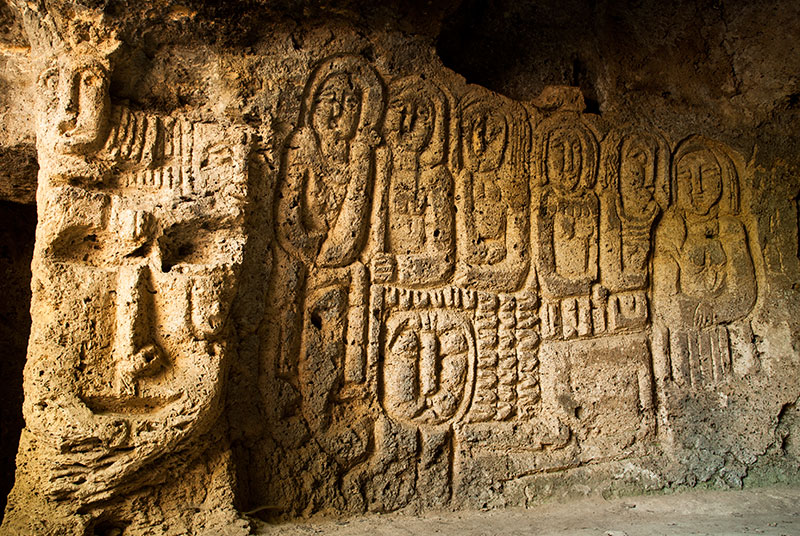
Petroglyphs, Anapat Cave, Tavush Province, Armenia
In addition to its beautifully serene location, the tenth-to-thirteenth buildings which make up Makaravank Monastery have some of the finest stonework in Armenia, and are all executed in pink tuff or andesite. The main, early thirteenth century Mother of God Church has an altar carved with geometrical and floral patterns very similar to those seen in Persian mosques and mausoleums, and an exterior whose smooth pink stone is delicately carved into window niches, blind arches around a circular tambour, and fine decorative pieces such as the sundial on the southern wall.
Rejoining the main road heading southwards and turning off at the edge of the town of Ijevan, I climb into the hills and park the truck at the edge of a holiday resort which marks the end of the track. I walk into thick, beautiful woodland of oak and hornbeam, dropping after some time into the gorge of the Sarnajur River, which has been carved out of the native limestone. Here one finds a series of natural caves, said to have been inhabited in ancient times and a place of refuge during the Mongol invasions. One of these, known as the Anapat Cave, is richly carved; most strikingly with a large mask-like face which looks almost pre-Columbian American in style, with six human figures standing next to it. Crosses are found carved elsewhere in the cave, but the mysterious portraits are allegedly pre-Christian.

Lake Sevan, near Drakhtik, Gegharkunik Province, Armenia
Some distance south of Ijevan, I leave the main highway, which leads to the capital, and turn eastwards, climbing steadily along the beautiful Getik Valley, then south across rolling, treeless grassy hills, finally dropping down in the beautiful late afternoon light to the shores of Lake Sevan. At 1900 metres elevation, Sevan is the highest of three large alpine lakes in the region (Van and Urmia being the others) and its dark blue waters, ringed by mountains, are spectacularly beautiful. I drive a little down the coast, looking for a campsite until I spot a distant promontory. After driving down a dusty track, I have to negotiate a ploughed field, then tractor up a steep grassy hillside in low-gear, but the truck reaches the top without hesitation and I am rewarded with a glorious, solitary campsite above the lake, with panoramic, 270 degree views across its shimmering cerulean waters towards the ridges of the Geghama Mountains to the west. Cooking dinner whilst watching the sun set, I am once again living my dream, using the capabilities of the truck which I have recently spent so much time and effort in restoring.

Armenian Woman, near Tsaghkashen, Gegharkunik Province, Armenia
After a beautiful night sleeping under the stars, I drop back down to the lake, and after a refreshing dip in the water, drive north along the attractive north-eastern shore, which is lined by rows of pines on sandy beaches from where fishermen launch small boats. Rounding the northern tip of the lake, the road leads to the town of Sevan where I stop at the Monastery of Sevanavank. In contrast to my tranquil overnight stop, the monastery is crawling with tourists, trinket sellers, hawkers and beggars. The smell of greasy food hangs in the air and cheap Russian pop music can be heard over the sounds of jet skis on the lake below. It’s rather far removed from the dignified monasteries hidden out in the villages; all the more ironic given that Sevanavank is one of Armenia’s few still active monasteries.
Escaping the tourist circus, I continue down the western shore of the lake which is far less attractive than the east coast with a scrubby, low-lying littoral. I stop at the Monastery of Hayravank, whose interior of orange and black tuff stones is dimly lit by a skylight in the dome of the main twelfth century church, and where I witness a family sacrificing a chicken just outside. Further south I stop at the medieval cemetery of Noratus, where dozens of beautifully carved khachkars and tombstones, some engraved with the objects and activities of the deceased who are interred below, lie in glorious isolation and mostly coloured bright orange by the growth of lichen.

Geghama Mountains, Kotayk Province, Armenia
I wish to make my way westwards via the Geghama Mountains which separate Lake Sevan from the central part of the country, and so drive from Noratus up into the foothills, to the village of Tsaghkashen. I stop to ask directions from a house in the village, and as well as pointing out the path ahead, the family fill my bottles with drinking water and hand me a sheaf of fresh lavash; paper-thin Armenian bread, fresh from the oven. A track leads up and out of the village, into grassy hills filled with the summer camps of cow and sheep herders. I stop frequently to ask directions, at one point being invited for a cup of sweet black coffee from by a mother and son who are staying in a wagon high in the hills. The track as such soon disappears however, and I am left crawling through deep ruts and over rocks, and it’s after sunset by the time I finally find a track which heads high into the mountains. I follow the track carefully in the dark until it levels out at just over three thousand metres, then stop and camp for the night.

Mount Ararat from Mount Aragats, Aragatsotn Province, Armenia
I wake after a cold but pleasant night on a beautiful, grassy, volcanic plateau, with several soft, ancient cinder cones to the west, whose dark red rocks are in places delicately shaded by green grass. The track ahead soon disappears again, so I climb a ridge on foot and plan my way forward through fields of boulders to the blue waters of nearby Lake Akna, where I hope to find another track running south-westwards to the village of Geghard. Despite crossing trackless terrain, the drive is straightforward but after considerable searching in the vicinity of the lake, I see that there is only one track, leading westwards towards the provincial capital of Abovyan. Descending the rough, rocky track, I pass a string of villages, then drive through Abovyan, by-passing the northern edges of Yerevan. The road runs along the southern edge of Mount Aragats, through a landscape which reminds me of southern Crete, with orchards and fields of parched yellow grass overlooked by volcanic peaks. In the city of Ashtarak I turn north, then take a side road which joins another road winding up the slopes of Aragats, built to service the Aragats Cosmic Ray Research Station, which sits at 3200 metres under the mountain’s southern summit. Reaching the end of the road, I turn and drive a little further beyond the buildings onto a steep hillside and find a place to stop for the night.
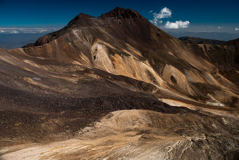
Mount Aragats (4090 m), Aragatsotn Province, Armenia
In the morning I leave the truck on the mountainside and walk up to the southern summit which at 3888 metres altitude is the lowest and also most accessible of the mountain’s four summits. Ever visible, off to the south are the two peaks of Greater and Lesser Ararat, respectively eighty eight and ninety six kilometres away, in Turkey. The two peaks of this highly prominent, dormant volcano are deeply ingrained in the Armenian soul. For much of history they were the symbol of Armenia (they are even pictured in profile on the entry stamp to Armenia made in my passport), yet for generations they have hovered in the Armenian consciousness as a painful reminder of their tragic history, just as they now hover mirage-like in the haze, tantalisingly out of reach across a sealed border. In less than two hours I am on top of the south summit, looking across a yawning caldera of craggy, beige and chocolate-brown rock, which I have all to myself until the arrival of a somewhat elderly German tour group.

Saint Christopher Monastery, Aragatsotn Province, Armenia
After a lengthy descent, the road from Aragats leads directly to the main Yerevan – Gyumri Highway where I turn west, driving around the southern edge of the volcano towards the Turkish border. I drive as far as Mastara to see the seventh century Church of Saint Hovanes, which has never been significantly renovated and whose bulky, squat dimensions remind me of later Mongol and Seljuk architecture in Persia and Turkey. Grass grows over its broad octagonal dome, echoing its slightly forlorn location in a quiet village, set well back from the highway. I double back for a short way from Mastara, turning south and passing through Talin and the stone fortress village of Dashtadem, leaving the main road and stopping for the night on a rock-strewn volcanic terrace. In this very picturesque spot, I am overlooking the small, restored but unused seventh century Saint Christopher Church which sits on the edge of the ancient lava flows of Aragats. Beyond, to the south, the glacier on the peak of Mount Ararat is just visible through the interminable haze, gleaming in the last of the evening light.
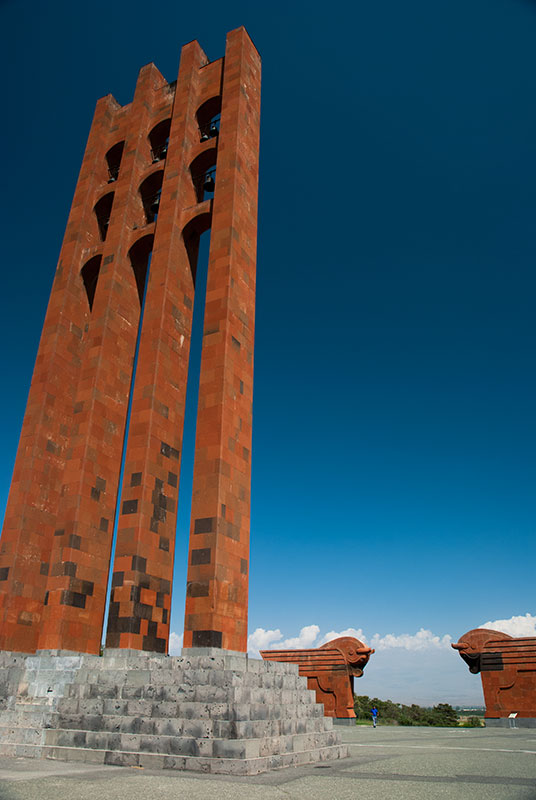
Sardarapat Memorial, Armavir Province, Armenia
Leaving my campsite after a relatively warm but windy night, I descend the volcanic hills and reach the fertile Ararat Plain, which constitutes something of a heartland of Armenia. I drive on almost empty roads to the Turkish border, climbing a ridge overlooking the red-orange landscape where the Aras and the Akhurian meet. I have a good view up the Aras Valley into Turkey, looking at a road I had hitch-hiked along more than eleven years ago. My reason to come here is that the two small villages on the border, Yervandashat and nearby Bagaran have historically both been capitals of Armenia, and I intend to have a look for any interesting remains. Dropping into Yervandashat, I get the impression that it’s unusual for a foreigner to be seen here and I am soon stopped by a young man in an official-looking car. My fears that I have strayed into a restricted border zone soon evaporate however as I am invited into the home of the mayor, whose nephew and very attractive niece both speak English, and explain to me whilst plying me with coffee and sweet slices of watermelon that nothing survives from this history, though they obviously flattered that I take an interest in it. Whilst Armenians may in some ways be regarded as European, their deep, intrinsic hospitality is undoubtedly Asian in its frankness.
I drive west out of Yervandashat passing the abandoned spur of a highway which in better times would lead to a border crossing with Turkey. Soon villages start to appear more frequently as I enter the irrigated lowlands which spread all the way to the capital. I stop at the Sardarapat Memorial, a striking fusion of Armenian red tuff and Soviet brutalist styles with winged oxen and a thirty-five metre bell tower inspired by medieval Armenian memorial stelae. The monument was constructed in 1968 on the fiftieth anniversary of the Battle of Sardarapat, which saw scant Armenian forces fight off the Ottomans, who in May 1918 were sweeping towards Yerevan following the withdrawal of Bolshevik forces from the region. Given that this was just three years after the Armenian Genocide, when Armenians had been effectively exterminated from many of their ancestral lands, a victory here for the Turks could have put an end to the Armenian state altogether, and thus the victorious battle is commemorated as having saved Armenia from being relegated to history books.
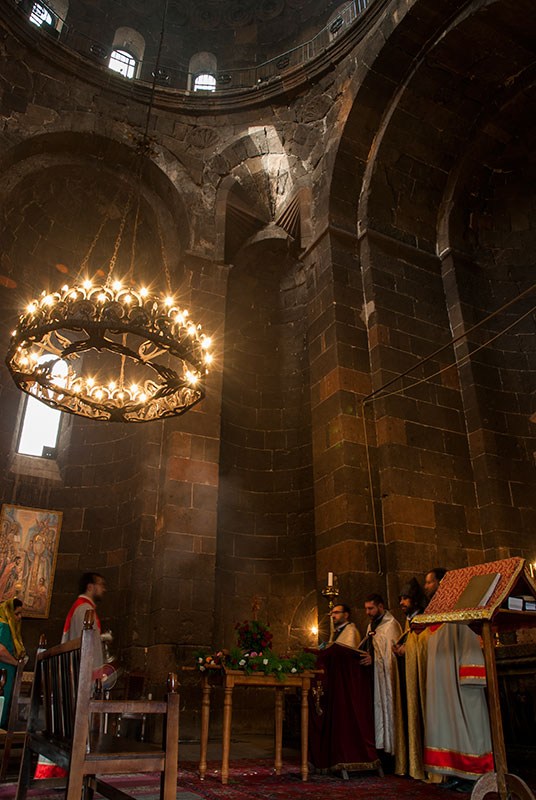
Saint Hripsime Church, Vagharshapat, Armavir Province, Armenia
From the monument I drive through the shabby regional capital Armavir, continuing east past Metsamor with its elderly Soviet nuclear power station, and stop in the city of Vagharshapat. Here I am hosted by Karine, who lives in a terraced house with a garden on the northern edge of the city, with her father, sister and niece. Vagharshapat is colloquially known as Etchmiadzin as it is home to the Mother Sea of Holy Etchmiadzin, seat of the Armenian Apostolic Church. The Church is very much central to the Armenian identity; marking Armenians out as one of the oldest Christian communities. It also marks Armenia as the oldest Christian country, with Christianity having been proclaimed the state religion in the fourth century, with roots claimed to go back to first century apostles Bartholomew and Thaddeus (Jude).
Karine, who works in the city as a tour guide, takes me to see the Etchmiadzin Cathedral, allegedly dating from the early fourth century, which would make it the world’s oldest cathedral. Having often been damaged and rebuilt however, the earliest parts of the structure now date from the fifth century, and from the exterior the undeniably beautiful stonework represents a fusion of Armenian styles from throughout the ages. Inside, the cathedral is beautifully decorated with seventeenth and eighteenth century frescoes and houses a museum, though I must admit to being more impressed by the stunningly beautiful girls staffing it, rather than by any of the aged trinkets or robes which Armenian visitors regard with great veneration.

Zvartnots Cathedral, Armavir Province, Armenia
More interesting to me is the nearby seventh century Saint Hripsime Church, an elegant cross church which vies with Georgia’s Jvari Monastery as the archetype for this uniquely Caucasian evolution of Byzantine design. Karine and I enter whilst a service is going on; a robed priest is giving a sermon whilst an acolyte swings a thurible, filling the air of the church’s brooding stone interior with fragrant incense. Once again I notice a rather light-hearted air in the church, with the priest and congregation laughing as a particularly dense billow of smoke engulfs the priest, momentarily interrupting him.
In the evening Karine and I drive out to the ruins of the seventh century Cathedral of Zvartnots, whose original form is unknown, beyond the ground floor of a tetraconch surrounded by a thirty-two sided gallery, which would have looked circular. Some historians reconstruct it with three concentric tiers, like a miniature Tower of Babel, though this would have made it one of the most technologically advanced structures of its day, and might be aggrandised by the Armenian’s great pride in their own history. Whatever the reality, the rotunda of partially intact arcades on Greco-Roman pillars are quite a doleful sight as they catch the last rays of red sunlight lancing through the stormy grey sky.
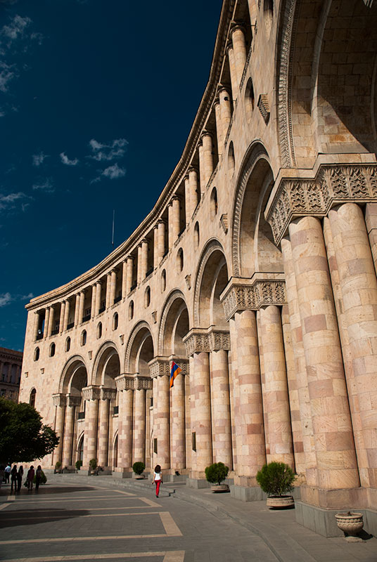
Republic Square, Yerevan, Armenia
After two nights in Vagharshapat I say goodbye to Karine, thankful both for her hospitality and her kindness in showing me around Armenia’s holiest city. It’s just fifteen kilometres to the outskirts of Yerevan, the capital, and I drive immediately to the northern edge of the city to visit the Iranian Embassy and the nearby ‘Permanent Representation’ of the internationally unrecognised Nagorno Karabakh Republic. With visa application forms collected, I drive down into the city centre and reach a backpacker hostel where I will base myself for the next week, taking the first real rest since leaving the UK more than three months ago.
My first impressions of Yerevan are of a being a strongly Soviet city, but with distinctively Armenian architectural flourishes such as the use of pink and black tuff as in the provinces. Indeed, Yerevan expanded very rapidly in Soviet times from a provincial town of the Russian Empire to the capital of a republic. Since independence the capital has seen a small decline in population due mostly to economic migration, but also the outflow of ethnic minorities such as Russians and Azerbaijanis. Nevertheless, the city remains home to just over a third of the country’s population and with an influx of remittances from the large and often wealthy Armenian diaspora, the city contrasts starkly with the shabby provincial towns and impoverished villages. Yerevan lacks the raffish charm of Tbilisi and is rarely particularly scenic, but is feels suave, confident, prosperous and happy.
Sayat-Nova Avenue, Yerevan, Armenia
I start my exploration in the city centre, in Republic Square, which is a large, elegant, yellow tuff piece of Soviet Neoclassicism. Here one sees the usual post-Soviet nouveau riche in blacked-out SUVs; senior civil servants and businessmen milling around the central government offices. Walking generally south, I pass through some streets of terraced, late nineteenth century stone houses, then come to a large junction where the architecture is decidedly Soviet. Crossing the road, I enter the pleasant ‘Green Belt’, a strip of urban park which surrounds the eastern half of the circular city centre. Along its pathways of slightly crooked concrete slabs, mostly elderly people are packed on benches sitting, talking and reading newspapers under tall plane trees in what remains an unspoiled piece of Soviet urban planning. I walk much of the length of the park, before descending into the city’s metro system. The Soviet-era metro has a distinct feeling of under-use, with trains far shorter than those which the stations were designed for. Some of the stations are quite elaborately decorated however, particularly the Sasuntsi Davit Station, which has wall sculptures of orange tuff from Armenian folklore. I ride the metro to its southerly terminus, then walk out of the station to find scruffy, sprawling suburbs and plenty of derelict industry, but by chance happen to catch a pair of Russian MiG 29s from the nearby military airbase making manoeuvres directly overhead; a reminder that I am less than fifteen kilometres from the Turkish border, one Russia regards as its own border with NATO.
Erebuni Fortress, Yerevan, Armenia
On another day, I start in the north of the centre at Freedom Square, walking north and climbing up the Yerevan Cascade; a giant stairway with intermediate tiers of carved stonework, an unusual fusion of Soviet Socio-realism and traditional Armenian styles. The top of the Cascade appears unfinished, but after a slight diversion around a derelict building site, one reaches a viewing gallery overlooking the city centre, though Ararat remains illusive in the late-summer haze of dust and pollution. Here a lonely concrete obelisk commemorates fifty years of Soviet Armenia, and steps lead further up to Victory Park and a statue of ‘Mother Armenia’ on a towering concrete plinth housing a museum of the Great Patriotic War; all very much Soviet monuments to a past which I imagine is becoming ever less important in independent Armenia.
The city has a number of museums; sadly the Museum of the Armenian Genocide is closed in preparation for next year’s centenary, but I spend a good few hours in the National Gallery which houses a mixture of Russian, European and Armenian paintings. More interesting however is the Urartian site of Erebuni in the far south of the city. Founded in 728 BCE, Erebuni Fortress, the namesake of modern Yerevan, was an important Urartian city and today houses an excellent museum of Armenian history. The Urartians, a regional civilisation who traded with the Elamites and Ancient Greeks, are regarded by Armenians as being their cultural forebears, with many Armenian legends having apparently Urartian origins. Certainly, the Urartians’ great mastery of stonework seems to have been inherited by the Armenians. Climbing the hill behind the museum are the modest remains of Erebuni, with a few ruined column bases and some Urartian cuneiform inscriptions which an Italian archaeologist points out to me. One last museum I visit is the Mesrop Mashtots Institute of Ancient Manuscripts at Matenadaran; a repository of beautiful illuminated manuscripts and a celebration of the Armenian alphabet, the latter of which has been pivotal in the survival of the cultural identity of a people who usually lived as a minority, yet who resisted complete assimilation into the empires of the Persians, Turks or Russians.

Stonemasons. Matenadaran, Yerevan, Armenia
Aside from the city’s obvious attractions, I enjoy my time in the hostel meeting various travellers who pass through, one of the highlights of extended overland travel. Armenia is the nearest ‘free’ country which Iranians can visit visa free, and there are a remarkable number of young Iranian men indulging in alcohol and other delights which the city has to offer, often to excess. I meet Sebastian, a Swedish engineer whom I met in Samarkand in July 2011 and who is by chance spending a weekend in the city. I also befriend Ace, a young Filipino nurse living in the UAE who I will later meet again in Karabakh. Thus I spend a week in Yerevan exploring, relaxing, drinking beer and enjoying the company of fellow travellers.
This first part of my journey through Armenia has shown me many of the country’s highlights; its greatest pieces of architecture, largest cities, highest mountain and its natural jewel, Lake Sevan. The second half of my journey through the Lesser Caucasus would take me to the more rugged south, with two separate journeys into the de facto independent Nagorno Karabakh Republic, and a final drive down the spine of the country to the Iranian frontier.
