
Stage 44 – Russia: The Siberian Winter [1/3]

Returning to Western Europe in October 2017, with the Hilux Surf in covered storage in Magadan, I had just three months to wait before beginning the winter journey for which I had been planning and preparing for two years. I found myself feeling more nervous than in the lead up to any other part of the Odyssey so far; perhaps I was really about to embark on the most dangerous adventure of my life, or perhaps I was just getting older and unwillingly adapting to a predictable, mundane life in the utter doldrums of north-western Europe. I sometimes found myself lying awake at night wondering how the car would react to temperatures potentially below -40º C; how I would deal with a breakdown or crash; how I would gauge the strength of the ice on the Lena River or Lake Baikal. I also did not know for sure that the trip I had planned was actually possible, as large parts of it were on impermanent, seasonal winter roads that were subject to weather and the resources and needs of local communities. I realised however that my concerns lay less in the risk of discomfort, damage to the car, or even personal harm, and were focussed on a clear fear of failure; to have to retreat from the winter roads and in essence re-trace my 2017 journey on normal roads.
I was about to embark upon a gruelling winter trip, crossing some of the coldest and least-accessible parts of Eurasia in the depths of winter, staying as much as possible on ice roads or zimniki made through frozen swamps and across the frozen surfaces of rivers and lakes. My proposed route would take me back along the Kolyma Highway, then far up the Lena River, down through the lower Tunguska Basin and across Lake Baikal, then a necessary run along the normal road network and back onto ice roads through the Vasyugan Swamp and up to the Arctic to meet the lower reaches of the Ob River. Unlike other journeys, this would be expedition-like; there would be few specific sites of cultural interest; instead, I would be pitting myself and the car against the harsh beauty of an immense, frozen wilderness; travelling solo across the Siberian Winter.

Sea of Okhotsk, Gertner Bay, Magadan, Magadan Region, Russia
I land in Moscow’s Sheremetyevo Airport in the early hours of the morning of the 13th January 2018, heavily laden with winter clothing and car parts, and wearing winter boots which are far too warm for Moscow’s mild winter. I take a taxi to the apartment of my friend and colleague Tom and, after a brief sleep and some last-minute shopping, we part over a couple of bottles of Armenian Kilikia beer. I take another taxi to Moscow’s Vnukovo Airport and board an overnight flight to Khabarovsk, which lands on a beautifully sunny, clear winter morning with bracing air temperatures of -26º C. After a connecting flight to Magadan, I am collected by my friend Oleg and his friend Sergey, who drive me the fifty kilometres from the airport in Sokol to the apartment of my hosts, Zhenya and Kate, whom I had met only briefly last October. Whilst Magadan is a quite pleasant -25º C, inland temperatures have dropped to -60º C in Oymyakon; a thought which I find both thrilling and slightly worrying.

Pacific Ocean, Avachinsky Bay, Petropavlovsk-Kamchatsky, Kamchatka Territory, Russia
I spend a week in Magadan doing some final preparations on the car; blanking off the radiator with insulation, buying an engine blanket and fitting a second windscreen which I had ordered last October. Oleg helps me greatly in finding everything I need and in offering advice on my preparations. I make the first drive of the year with Oleg, out of the covered parking lot into town, then out onto the frozen surface of the Sea of Okhotsk in Gertner Bay on the city’s eastern edge. It’s an odd sensation to be driving on the sea, over a series of pressure ridges near the shore and out onto unbroken salt-water ice, which I find has a strange roughness to it. Despite being illegal, the sea surface is busy with local ice-fishermen and their four-wheel drives, though every year cars are lost from falling through thin ice. I stock up with supplies, including a number of Russian Army food ration packs which Oleg recommends, fill up with fuel, then put the car back into the covered car park while I make a week-long side-trip.
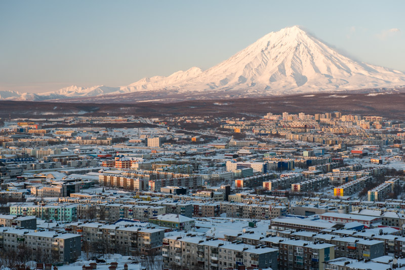
Koryaksky Volcano, Petropavlovsk-Kamchatsky, Kamchatka Territory, Russia
Normally, I would never entertain the idea of flying to a new destination, but I make an exception in order to pay a winter visit to Kamchatka, boarding a turboprop flight to Petropavlovsk-Kamchatsky. I am greeted by low clouds, wind and warm temperatures hovering very close to 0º C making the rather charmless modernity of Petropavlovsk look no different from a suburb of Moscow. A large winter cyclone is responsible for the foul weather, though it is still thrilling to stand truly on the eastern edge of Eurasia, looking out to the Pacific Ocean. Only when the cloud lifts one afternoon am I greeted with a magnificent view over the city to the dramatic, snow-covered volcanoes Koryaksky and Avachinsky whose fluted, gleaming flanks make the place seem suddenly exotic. Although I manage to make a trip to a nearby husky camp, and sit outdoors in a natural hot spring while the worst of the cyclone wind blows overhead, the weather precludes any exploration of the peninsula and I am keen to return to Magadan and start the drive west. My flight to Magadan is however cancelled, meaning I have to make a spontaneous detour to Khabarovsk. The upshot of this is that I am kindly offered a place to stay by Semyon and Nastya, whom Maciej and I had stayed with last year on the outward journey to Magadan, and with whom I spend another lovely evening eating and drinking at the kitchen table.
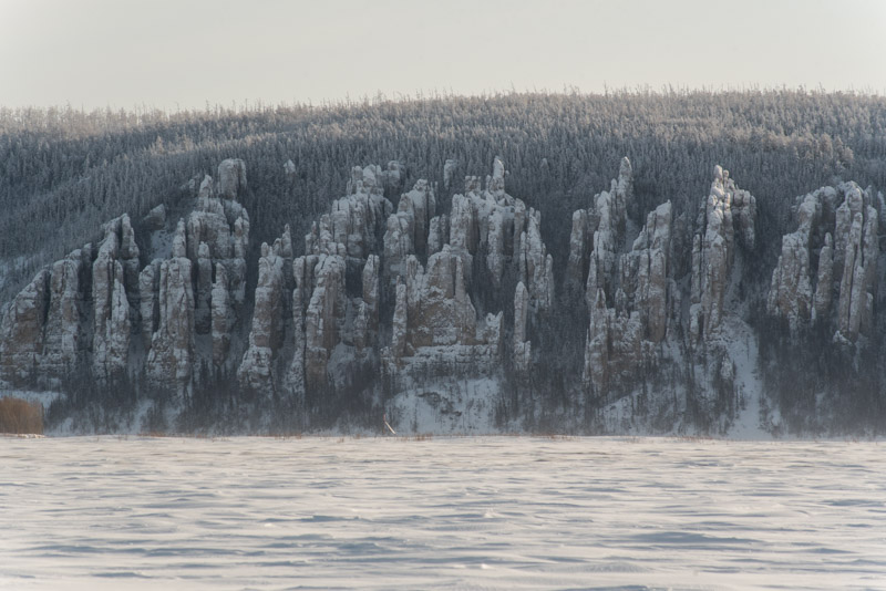
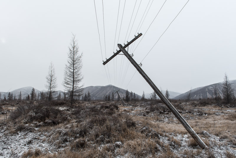
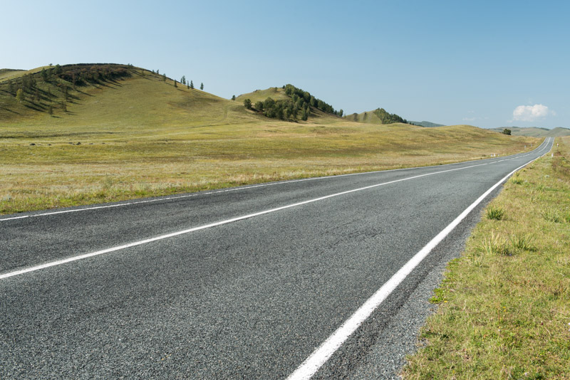
Kolyma Highway, near Atka, Magadan Region, Russia
Unfortunately, on returning to Magadan I run into the cyclone once more; gone are the cloudless blue skies and cold, crisp days, and also the sea ice on which I had driven just over a week ago. Inland, temperatures have risen from around -50º C to around -15º C in a matter of days; a great disappointment. The time comes however to leave, so I must say goodbye to Oleg, who has been so generous with his time in helping me; to Zhenya and Kate who have been so generous in hosting me, and to Magadan which I have grown very fond of; a friendly, welcoming outpost at the edge of the world. I leave early in the morning of the 30th January during a howling blizzard, driving out of the dark, sodium-yellow streets of the the sleeping city with the temperature creeping up to 0º C; just about the worst condition imaginable. Immediately I have problems with liquid water lifting the tape sealing down my second windscreen, causing condensation to form in the gap between the two screens which is difficult to clear. The snow is thick on the passes north of the city, but I make it through into a dull, overcast day.

Kolyma River, Debin, Magadan Region, Russia
As I drive northwards on the Kolyma Highway, the temperature slowly drops to -18º C as I leave the worst of the snowstorm but the clouds remain, meaning there are no shadows to indicate the texture of the snow surface. This makes driving rather difficult and after a momentary lapse of concentration in the early afternoon, I drift off the invisible road and down into the thick snow of the berm. I am immediately recovered by a gentleman in a passing Landcruiser, with no damage to the car aside from having to remove the outer windscreen as the crash has filled the cavity between the screens with snow. I stop for lunch in Orotukan, where the highway turns westward and in the afternoon see my first glimpses of light in the sky before crossing the Kolyma River in the town of Debin. I drive on into the night, cursing the cyclone for pushing up temperatures, bringing heavy snow and robbing the landscape of the deep-frozen beauty I was hoping to see. I pass Yagodnoye and Susuman in the dark and, late in the evening, reach the small town of Kholodny, where Sergey’s brother meets me and guides me to an avto baza; a large, heated communal garage where I spend a very warm night sleeping in the car.

Kolyma Highway, near Ust-Nera, Sakha Republic, Russia
The next day I soon pass the turning to the Tenkin Route which I took southwards last October, and so begin a long section of back-tracking towards Yakutsk. The road begins to get very quiet and the snow deeper as I climb out of Magadan Region and into the Sakha (Yakutia) Republic, passing the old Soviet obelisk marking the regional border at the forlorn settlement of Delyankir, whose sole inhabitant lives in the weather station in what is one of the world’s coldest settlements. The road improves in Yakutia and by evening I reach the rough mining town of Ust-Nera, where I stay in a very basic but very friendly hotel adjoining a small heated garage, where the owner makes a very neat job of re-attaching my second windscreen. As I cross the Indigirka River the next morning and begin climbing into the Chersky Range, the temperature is -27º C though I am startled by the strong temperature inversion, recording just -10º C at the top of the pass, which creates a layer of condensation all over the outside of the car. Finally, at around midday I outrun the wretched cyclone which has been following me since Kamchatka and am delighted to emerge into an utterly still, frozen wilderness where the deep blue sky contrasts beautifully against the still, snow-laden trees. Finally, I am seeing the winter landscapes I had been dreaming of, although the temperature is only -22º C rather than the -50º C I had been hoping for.

Road of Bones, near Kyubeme, Sakha Republic, Russia
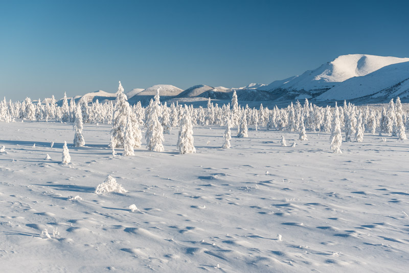
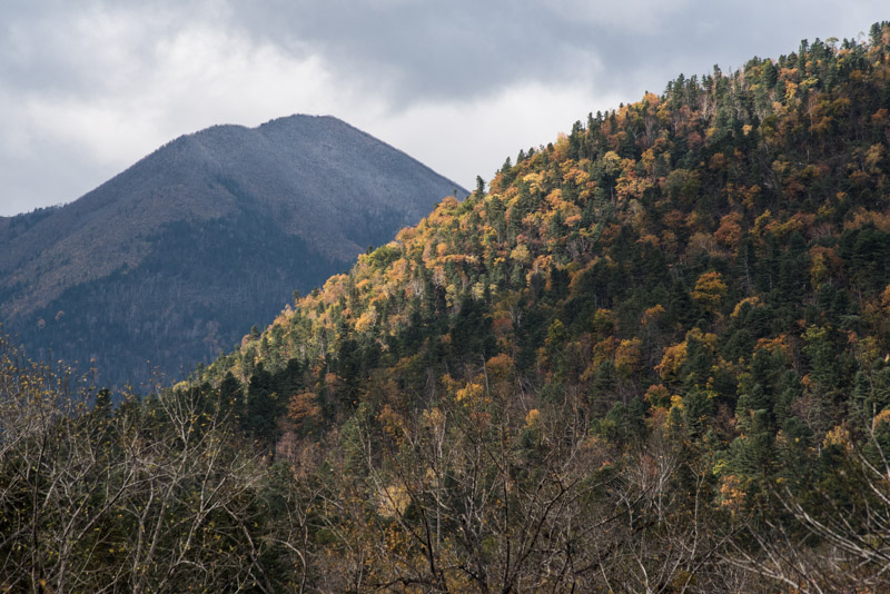
The temperature drops in the afternoon and the landscape takes on an ever more haunting beauty as the sun very slowly drops towards the horizon and my worries dissipate. I find myself in what is certainly one of the most beautiful places I have ever been, marvelling continually at the beauty of the trees freshly coated in snow yet frozen in absolute stillness; the utter emptiness and stillness on the road, where I pass just a few trucks; the vast, untamed wilderness sprawling in all directions and the fact that the Hilux Surf is performing utterly flawlessly in the cold as I drive through the winter scenes I have been dreaming of seeing for so long. I stop for fuel at a lonely petrol station which is staffed by the last inhabitant of the abandoned settlement of Kyubeme, then turn off the modern highway and onto the original Kolyma Highway, the infamous ‘Road of Bones’, which leads back eastwards towards Oymyakon, the world’s coldest permanent settlement. Here the scenery becomes yet more fantastic as the narrow, perfectly white track winds through a forest of larch trees heavily coated in snow. Occasionally trees overhang the track under the weight of their snow colour, their perfect white forms contrasting with the other-worldly blue-black sky. I stop to have tea and admire my surroundings as the temperature drops to around -35º C and I feel the magic of the deep winter. A little further down the road, just before darkness falls, a reindeer herd emerges from the forest; beautiful, inquisitive creatures who cautiously approach me in hope of being given salt.

Yakut Man, Tomtor, Sakha Republic, Russia
Late in the evening I reach the town of Tomtor, beyond which the original Kolyma Highway has been abandoned and is unmaintained, making it too dangerous to have taken from Magadan Region. I see signs of life in a sports centre and go inside to ask about a heated garage. Soon enough I drive with a lady to the large home of Innokenty, an 82 year-old, rather deaf Yakut gentleman who guides me into a wooden garage and lights the stove. I spend another very comfortable night here, pushing on to Oymyakon the following morning. Whilst Oymyakon holds the record for the coldest ambient temperature recorded anywhere outside of Antarctica, I arrive on a snowy, overcast morning when the temperature is a comparatively sweltering and disappointing -29º C. It is nevertheless a friendly, lively Yakut village and I decide to spend the day there. I check into a homestay run by local historian Tamara Yegorovna, and after speaking to a gentleman in the city administration, am given a free, heated garage to keep the car in. I spend the day walking around town, trying to imagine what it would have felt like to be here two weeks earlier when the temperature was thirty degrees lower.
Verkhoyansk Range, near Kyubeme, Sakha Republic, Russia
I leave Oymyakon early in the morning and drive in the dark back to Tomtor, with the sun rising to reveal another clear day with stupendous views through the still but dazzling landscape, with sweeping views over endless forested ridges of utter wilderness. Rejoining the modern highway I climb gently through the upland which separates the Chersky Range in the east and the Verkhoyansk Range to the west. The views here are again magnificent with a broad valley of wind-sculpted snow dotted with trees wholly frozen in place by a thick coating of snow, backed by gorgeous, sculpted peaks whose ridges gleam in the late afternoon light. Crossing a gentle pass I descend along the Vostochnaya Khandyga River, entering frozen lowlands where the temperature drops to -40º C and the world is ethereally still, each shape picked out in sharp detail as far as the eye can see in the absolutely dry air. At these temperatures I can feel the car’s brake and clutch pedals stiffen as the hydraulic fluid thickens, but there is otherwise no noticeable change in how it runs.

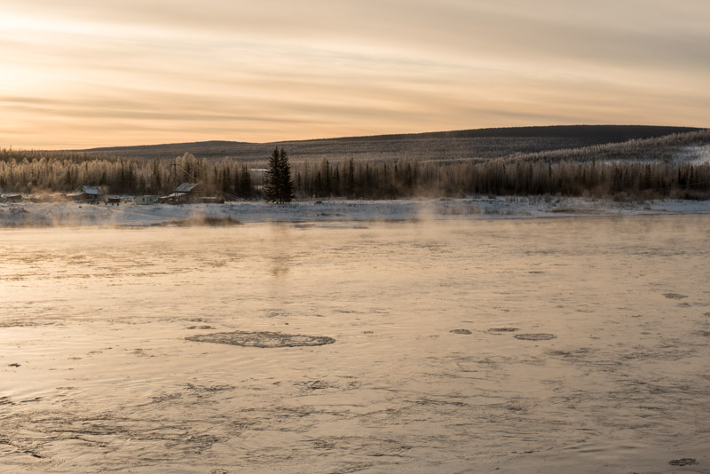
Aldan River, Khandyga, Sakha Republic, Russia
In Khandyga I meet Rustam once more; this time at his family home, outside which I leave the car with the engine running whilst we have a cup of tea and catch up, before driving to a large heated garage where I safely store the car. I took an instant liking to both Rustam and Khandyga when visiting last year and so I am happy to accept Rustam’s offer to spend a rest day here. Although the family stay indoors when possible during these depths of winter, I decide to take another look around town, wearing my warmest clothes and heading down to the totally frozen Aldan River. I walk on the river for a kilometre, listening to the different sounds that my feet make on the thick, snow-covered ice and breathing the numbing cold air, my breath causing my facial hair to become coated in ice. Here I come across my first ice road which has been cleared across the Aldan, and I stop to watch cars shuttle across the river to a village on the opposite bank, imagining the hundreds of kilometres of ice road I hope to drive on the Lena River.

Saint Nicholas Church, Cherkyokh, Sakha Republic, Russia
West of Khandyga, the Kolyma Highway reaches the un-bridged Aldan River where the hour-long ferry trip which links the two sides of the river in summer is replaced by a ten kilometre-long ice road. This is my first experience of driving on a frozen river and I’m relieved to find that the ice, which is around a metre thick, is as hard as rock and feels far more solid than the sea ice I had driven on in Magadan. Once on the river’s left bank, I drive through a series of small towns and villages which are something of a heartland of the Yakut people; Turkic herders who were displaced from the Baikal region by the Mongols starting in the thirteenth century and have come to live by herding cattle, horses and reindeer in these coldest inhabited parts of the planet. Initial contact with Russian explorers and trappers travelling down the Lena and Aldan Rivers in the seventeenth century brought subjugation, violence and disease to the Yakuts. Later however, they would become largely Christianised (though retain strong, syncretic animist beliefs) and brought into the Russian Empire; evidence of which I can see in the form of a fine, nineteenth century wooden church in the village of Cherkyokh. I drive on in the dark, reaching the town of Nizhny Bestyakh where the Kolyma Highway, and my backtracking, come to an end. I cross the river on a wide, two-lane ice road in the dark, with the outside temperature at -42º C. On the left bank of the Lena, I find Yakutsk, capital of the Sakha Republic and the world’s coldest city.

Victory Square, Yakutsk, Sakha Republic, Russia
I’m very lucky to have connections in Yakutsk; I firstly meet Misha, a close friend of Alexey, a Yakut friend and colleague of mine, who escorts me to his own private heated garage complex where I leave the car, then drives me back to the house of my host, Nariyana, who returns from work shortly after I arrive. Now, in the depths of winter, Yakutsk is numbingly cold with a midday temperature of -38º C and is enveloped in a pall of fog created by power stations, heating systems, vehicle exhausts and even people breathing. Vehicles move carefully along the streets in billowing clouds of steam which never dissipates in the totally still atmosphere; with only the faintest hint of the clear blue skies which lie just above the fog. Outside apartment buildings those who do not have a heated garage leave their cars with tent-like covers from which only the exhaust pipe emerges, with a timer to start the engine when the temperature drops too low. Aside from these idiosyncrasies of living somewhere far colder than a commercial freezer, life goes on as usual and the cold does little to faze the hardy locals. In the evening I meet Misha again and go to a ‘Scottish Pub’ owned by Dima, Alexey’s brother. It’s an evening of high spirits but I drink uncontrollably and wake up the next day disoriented in Misha’s apartment, being muzzled by his wife’s hairless cat and suffering a horrific hangover.
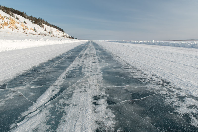
Lena River Ice Road, near Ulakhan-An, Sakha Republic, Russia
Despite the cold and my binge drinking, I like Yakutsk; although it is physically extremely isolated, lying more than one thousand kilometres north of the Trans-Siberian Highway on the far bank of the un-bridged Lena River, it feels modern and worldly; more so than many Russian cities. My host Nariyana is also a beguiling character; quiet, intelligent and astonishingly attractive, but my thoughts are preoccupied with the next leg of the journey, a twelve hundred kilometre drive up the frozen Lena River which is the section of the journey I am most worried about. I’m very keen to get information on the condition and even existence of the ice road, something I have not been able to do until now. Misha once again helps me, putting me in contact with his friend Ayal,a logistician who works for local oil companies. I am told that the road is clear until the town of Olyokminsk, but rather uncertain beyond that. I need to get as far as the city of Lensk to have a chance to connect to another ice road south through the taiga (boreal forest) towards Lake Baikal. There is an alternate route, a long detour on a normal road through the forests to the north, but my ambition is to drive as far up the river as possible. I am slightly reluctant to leave all my new friends in Yakutsk, but also nervously excited as I take the car from Misha’s garage and head out of the city’s fog and onto a paved which follows the Lena’s left bank. For what is the first day of the most significant section of this winter journey, it is perhaps fitting that this is Day 2000 of the Odyssey as a whole.
Lena Pillars, Sakha Republic, Russia
Emerging from the fog of Yakutsk, it’s a clear, cold morning; the temperature has jumped to -30º C but there is a bitterly cold wind which makes me feel colder than I have ever felt. I top the car’s tank up in Pokrovsk, foolishly venturing out of the car without a hat on and soon getting frostnip in the top of one ear. The road becomes smaller and very quiet until, in the village of Ulakhan-An, I follow a sign marked ‘avtozimnik’, descend the long bank of the Lena then venture onto a bulldozed but lumpy ice road. It is one thousand kilometres to Lensk and there is no alternative route to the ice road (apart from a private oil-company road which foreigners are barred from using). The ice road soon improves, tracking the Lena’s left bank and becoming a wide carriageway of smooth, translucent, deep blue ice. It’s a joy to drive on this section and I’m thrilled to be living out another experience I have long dreamed of, the Hilux Surf once again performing flawlessly. In the early afternoon I reach the Lena Pillars; beautiful eroded stone columns on the river’s distant right bank. A track across the river ice to the pillars is barred and the wind is unbearable, so I enjoy the sight from the warmth of the car with a cup of tea, watching eddies of windblown snow scurry across the ice surface.

Yakut Horses on the Lena River, near Sinsk, Sakha Republic, Russia
I drive on into the afternoon, passing perhaps one or two vehicles each hour, climbing off the ice road briefly to stop in the quaint village of Sinsk, a place accessible only by boat in summer and by ice road in winter. The population here is a mix of Slavic and Yaukt, giving it a different character to the almost purely Yakut settlements I have been passing through between Khandyga and Yakutsk. To the west the sky starts to fill with cloud, the wind picks up and as the light fades the first snowfall begins. The darkness however makes driving more relaxing, as the intense reflection from my headlights on the clean, white snow and ice mean I can easily discern the path of the road, despite the snowfall. I pause for dinner on a wide section of the ice road, carefully heating up Russian Army rations with a butane stove on the passenger seat with the window cracked. At around 22:00 the ice road diverts through the village of Sanyyakhtakh on the Lena’s left bank and I decide to stop for the night. With the temperature still -30º C, I park the car into the wind and settle down to sleep, leaving the engine idling and setting the separate cabin heater to 15º C. Stretching out on the bed platform in the rear of the car, very comfortable and in only my boxer shorts with a sleeping bag draped over me, I feel almost as if I am in a space capsule. It’s very satisfying to reap the benefits of all the time and effort I have spent in the last two years getting the Hilux Surf into perfect running order, and so well equipped to protect me from the potentially lethal cold outside.

Lena River Ice Road, near Sanyyakhtakh, Sakha Republic, Russia
The next day, conditions on the ice road have deteriorated; snow has fallen on the cleared ice and the sky is overcast, making it difficult one again to pick a path. I encounter a section of dreaded naled; a phenomenon whereby liquid water breaches the surface of the ice road, quickly re-freezing but leaving a water filled cavity between the newly formed ice and the thick ice of the river in which vehicles can become stranded. I manage to take a diversion through deep uncleared snow, but doubts start to creep into mind about how likely it is that I can make several hundred kilometres further to Lensk. Through the day, the conditions vary frequently, but I maintain progress, passing perhaps one vehicle every hour or so. As I get closer to Olyokminsk, the only sizeable town before Lensk, the road diverts inland and becomes dangerously slippery, causing me to slide and spin several times and I’m glad when the track switches back to ice. Eventually, in the village of Solyanka, I pick up a formal road, driving twenty-five kilometres into Olyokminsk where I stop to refuel. The formal road continues through a string of quaint, isolated villages in a beautiful landscape now forested with pine and birch, making it feel more familiar than the exotic, larch-filled Far East. Just over fifty kilometres from Olyokminsk I pass the village of Biryuk, then find a rough path back down to the river. Ayal has warned me that this next 360 kilometre section to Lensk is difficult and indeed, the ice road is narrow, rough, in places steeply cambered and covered in snow. There are no other vehicles around and I nervously make my way along the road, confident that with my supplies of fuel, food, water and very warm clothes, I can survive a few days stranded in case I get stuck in deep snow or by worsening weather.

Horse and Sled, Neryuktyayinsk-II, Sakha Republic, Russia
The ice road is initially quite gruelling; difficult driving due to a bad camber and patches of naled, backed by the slight anxiety of being alone, but I am determined to make it to Lensk. I make steady progress at around twenty kilometres per hour and am glad of nightfall when my vision improves. It’s an odd feeling to be driving absolutely alone, late at night on a remote, frozen Siberian river, with the sloping banks just visible to each side, slowly closing in on me as I progress up-river. I pass only one or two tiny villages on the river’s left bank and don’t see a single vehicle for several hours, but at one point several tracks converge and the ice road becomes wide and well maintained again. At around midnight, opposite the right-bank village of Macha, I encounter a large patch of what looks like naled in my headlights, but belligerently dash across it. Beyond the road seems almost unused and it is at times very difficult to pick a path through the snow, but eventually I make it to the small town of Chapayevo, somewhere I am extremely relieved to reach. Ayal has only been able to confirm that the ice road exists this far, but from the good quality of the cleared roadway leading out of town, I am confident that it must extend to the road-head at Nyuya. I decide to stop to sleep in the village but attract the attention of a local drunk dashing around recklessly in a Landcruiser and push on, eventually stopping, exhausted outside the quiet village of Turukhta at around 02:00 and sleeping again with the engine running all night. It’s a straightforward drive on the last section of ice road in the morning, though as I approach the landing at Nyuya the road enters a wide swath of wind-blown snow and dangerous-looking, glistening naled. I get stuck twice, once getting a tow out from a UAZ, and the other time digging myself free, meaning my nerves are rather frayed by the time I climb the river’s left bank into Nyuya, hugely relieved to find a good, all-weather road running the final one hundred kilometres to Lensk.

Lena River Ice Road, near Lensk, Sakha Republic, Russia
Lensk is a sizeable town and is the first place since I joined the ice road which is accessible by all-weather, public road from Yakutsk. My aim however is to drive the entire length of the Lena River Ice Road, which runs a further two hundred kilometres to the small town of Peleduy. The weather however is not looking good; a blizzard is blowing down the river and as I make my way to the embankment and look down at the descent onto the ice road, I see two cars stuck in deep drifts of snow. I drive up to the private oil company road which runs just north of town which could also take me to Peleduy, but am politely but firmly denied access. I return to the embankment in the bitterly cold wind, watching the locals extricating their cars from the snow. Just as I am resigned to spending a night in Lensk, waiting for the weather to improve and the road to be cleared, I meet Dima, a one-eyed man driving a four-wheel drive Toyota HiAce with his mother in the back. He is heading to Vitim, a town just beyond Peleduy and tells me that we can force our way through the drifts, beyond which the ice road, which he drove earlier in the morning, is passable.

Lena River Cliffs, near Lensk, Sakha Republic, Russia
Together we race and dig our cars through the thickest of the snow and onto the ice road which is the worst I have yet seen; the ice has heaved up onto the river’s left bank and the dangerous camber means I slide off into the large snow bank countless times. The river has narrowed here and we pass tall sandstone cliffs dotted with pines, which funnel the wind down along the ice road. Eventually I get the knack of driving; each time I feel the tail of the car beginning to break free I drop a gear and jab the accelerator to right it, then carefully try to lose the additional speed until the next time the rear starts to slide. It’s a thrilling, exhausting and nerve-racking drive and I’m very glad to be teamed up with Dima, who is a far more proficient ice driver and takes everything in his stride. At times our cars seem to be defying the laws of physics, clinging onto an almost frictionless cambered plain of smooth ice covered in powder snow, and I am quite sure I would have turned around by now if I were alone. The road makes several excursions into the forest on the river’s left bank; sometimes jarringly rough, at other times a smooth, narrow, high-speed bobsleigh track weaving through the trees. For the first time the ice road crosses to the river’s right bank at Yaroslavsky, then switches back to the left. We continue into the night, sliding and gunning our cars through deep snow with me forever following the red of Dima’s tail lights. Eventually we make landfall a final time, driving up into the sleepy, small town of Peleduy. I hug Dima a heartfelt goodbye, thanking him for his company before he drives his mother the final kilometres to Lensk on a normal road. I drive into the centre of town and call my hosts, who are shocked that I have made it along the ice road in these conditions. Before long I’m being fed and looking forward to a hot banya, a perfect end to what has been the toughest drive of my life. I’ve covered around twelve hundred kilometres between Ulakhan-An and Peleduy, of which I estimate nine hundred to have been on the frozen river itself.

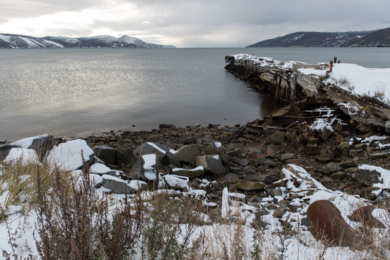
Scuppered Ships, Peleduy, Sakha Republic, Russia
After a very good sleep, I spend a rest day in Peleduy. My hosts Lyuba and Gleb are Russian (though Lyuba clearly has some Asian genes) and are frankly surprised to host a foreigner in their far flung town, though they welcome me generously into their modern house. Gleb has the day off and so we walk together around the friendly town, along streets with very little traffic, down to the riverside. Peleduy is an important port on the Lena and much of the river fleet, which in summer brings goods to this roadless swath of wilderness, lies dormant in the port at the mouth of the Peleduy River. Scuppered on the riverbank are several rusting hulks of slowly decaying ships, and on the river’s far bank towering jagged sandstone cliffs rise up, unseen by me last night. At the river’s mouth I also see the ice road heading out to the Lena on which I arrived last night. It’s a stark contrast in mood between the rigours and dangerous conditions of the ice road and the gentle, calm atmosphere of far-flung Peleduy.
Peleduy marks the end of the toughest section of the winter trip, but my route ahead is still far from certain. The next challenges will be getting permission to use a private road out of Peleduy, and later navigating a potentially dangerous route across the surface of Lake Baikal. I am still a long, long way from Russia’s road network.
Stage 43 – Russia & Kazakhstan: Trans-Eurasia [3/3]

From the edge of eastern Siberia, the last nine thousand kilometre leg of the journey to Magadan now lay ahead of us. This would first take us on a long detour into the lowlands of the Russian Far East, where we would find a string of vibrant, prosperous cities; a Russia which looks more towards the large Asian economies of China, Japan and South Korea than to distant Moscow. We would then head into a huge tract of wilderness; into the Sakha Republic, the largest of Russia’s constituent regions, immediately confronting the onset of winter with temperatures well below zero. After making the critical crossing of the Aldan River at the very end of the navigation season, we would continue on the infamous Kolyma Highway into Magadan Region, a place synonymous with brutal forced labour, dotted with abandoned towns and infrastructure, profound monuments to the ephemerality of human ambition in this awesome wilderness. Finally, in the snowy port of Magadan, we would complete our nine-week, 23,000 kilometre Trans-Eurasian journey, where I would put the car into storage in preparation for my return three months later in the real depths of winter.

Landscape, near Khalan, Amur Region, Russia
On the 16th September 2017, Maciej and I awake to a cool autumnal morning at our campsite above a flooded quarry now abandoned by the builders of the M58 Highway. It’s a strangely beautiful scene, with steam rising gently from the water which is surrounded by larch trees now losing their brilliant yellow needles. We are about sixty kilometres north of the northernmost point of China in the vast, almost uninhabited wilderness of the Stanovoy Range, which marks the boundary between Siberia and the Russian Far East. Rejoining the highway, we soon pass the turning to Magadan and spend the day driving gradually south-eastwards, dropping from the mountains into the lowlands of the Amur Basin. After 550 kilometres, at a junction overlooking Tsiolkovsky, the site of Russia’s new Eastern Cosmodrome, we turn onto a smaller road which passes through villages and small towns, giving the fairly abrupt feeling of having returned to civilisation. The road tracks the Zeya River through a pleasant though unspectacular landscape of low, autumnal oak forest and by late afternoon we reach the city of Blagoveshchensk on the Amur River and settle in with our host Tata, a host at a local radio station.
After early incursions of Russian Cossacks into the Chinese-controlled Amur Basin in the seventeenth century, the 1689 Treaty of Nerchinsk set the Russian border along the Stanovoy Range, with the Qing Dynasty (Manchu) rulers of China keen to keep Russians away from the Amur. This frontier wilderness was in reality only loosely controlled by China, and was slowly settled by Imperial Russia, which had ambitions of establishing a naval presence on the Pacific coast. In 1858 Qing-era China, weakened by war with the British and French, signed the Treaty of Aigun with Russia which set the Amur River as the border between the two countries. Blagoveshchensk was founded at around this time and was initially a point of cross-border trade, though for much of the twentieth century this border was closed due to hostilities between the two countries.

Amur River, Blagoveshchensk, Amur Region, Russia
Maciej and I set out the following morning to explore the city, heading straight for the river where we are greeted by a view across to the small Chinese city of Heihe, a sprawl of rather characterless apartment buildings. Today it’s clear that Blagoveshchensk hums with cross-border activity; the river is busy with tourist ferries and barges; there are numerous Chinese tourists braving the rain, presumably curious to make the day trip to this strangely European city right on their border, and the central market has a decidedly Asian flavour with stalls selling Chinese street food, tea, clothes and much else. We are struck by the sudden impression of being in Asia and an atmosphere quite unlike any city we have yet visited in Russia, with its curious mix of timeworn Russian infrastructure, frantic Chinese commerce and congestion of used Japanese vehicles. In the afternoon the rain stops and we invite Tata to join us on a short cruise on the river. Once we have boarded the small ship, we are soon bombarded by the ship’s loudspeaker system with cheap Russian pop music and a barrage of trivia about Blagoveshchensk whilst we ogle the Chinese side of the river; a glimpse of a huge and fascinating country I am eager to visit in more detail.

Birobidzhan, Jewish Autonomous Region, Russia
Leaving Blagoveshchensk the next day, we take a road eastwards across the lowlands along the Amur; a dull landscape of flat fields under a miserable, leaden-grey sky which reminds me very much of the Netherlands; a slightly disorientating pang of familiarity. In the town of Novobureyskiy we re-join the M58 and the landscape changes to low, rolling hills of lush-green deciduous trees showing only the very first hints of autumnal colour. We cross the border into the intriguingly named Jewish Autonomous Region and by mid-afternoon arrive in the capital Birobidzhan. What we find is a very nice example of a small town; streets lined by yellow-leafed lime trees, small urban parks and a very friendly and relaxed atmosphere. There are hints of Jewish culture; a large menorah monument outside the quiet train station, street-signs in Russian and Yiddish and a monument to the Yiddish author Sholem Aleichem, but there is nothing otherwise to suggest this is anything but a normal Russian town.
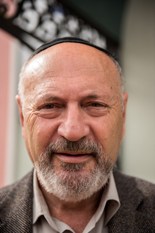
Jewish Man, Birobidzhan, Jewish Autonomous Region, Russia
In the morning we try to see a little more of the town’s Jewish credentials and head to the Beit Menakhem Synagogue which is set off from Sholem Aleichem Street behind a gilded statue of a horn-playing caricature of a Jew. We are warmly received by a custodian upon walking into the grounds of the synagogue, which is simultaneously an active place of worship, a community centre and a museum, which he is keen to show to us. In Tsarist Russia Jews were largely restricted to living in the Pale of Settlement, located along the Empire’s western border. Jews were made to live in cities and were subject to periodic pogroms, particularly during the chaos of the Russian Civil War. Shortly after the establishment of the Soviet Union, Jews were given rights similar to other minorities, with the Soviets promoting Yiddish language whilst repressing religious expression. This Jewish Autonomous Region was established with the intention of giving Jews a socialist Zion; a homeland where they could farm and refrain from traditional private enterprise, forbidden by the Soviet regime. It also served as a useful bulwark against Chinese incursions into this remote frontier, and both Jewish and non-Jewish settlers were attracted by the lure of free land. By the late 1940s Jews accounted for around a quarter of the population of the autonomous region, though numbers have steadily declined since, particularly from the 1980s when many Jews emigrated from the socio-economic malaise of the Soviet Union to Israel. Today, Jews make up perhaps one percent of the autonomous region’s population, but the synagogue’s main sanctuary is in active use, and we are told that some of the regions schools still have compulsory Yiddish classes.
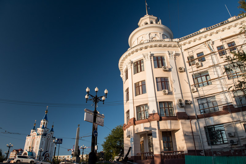
Komsomolsk Square, Khabarovsk, Khabarovsk Territory, Russia
We walk a little more around Birobidzhan’s friendly streets then, after lunch, head back out onto the M58, driving through a swampy landscape until we meet the Amur River once more, crossing it on a three kilometre-long bridge into the city of Khabarovsk. Here we are hosted by Semyon, a TV cameraman and his wife Nastya who live in a beautiful, spacious house on the northern edge of the city, built by Semyon’s father in 1991. We’re received like old friends into a warm family atmosphere and finish a very pleasant day with home-cooked food and wine. In the morning we meet Nastya’s friend Olya who by coincidence works for the same company as I, and who accompanies us into the centre of the city. Khabarovsk is centred on a grandiose street of Tsarist and Stalinist architecture, but what is most striking to me is the youthful vibrance and feeling of prosperity of the city, which is filled with happy, healthy looking people. We stop in a patisserie and later a craft beer pub as we make our way down the main street, visit the excellent regional museum and end the day walking along the embankment, overlooking a beach and the wide Amur River. As in Blagoveshchensk, I get the impression of seeing a new and rather different side of Russia.

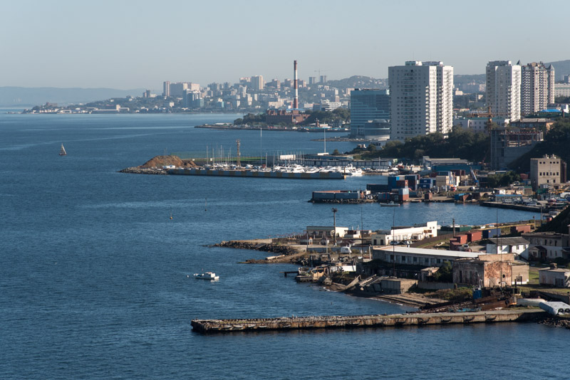
Fedorov Bay, Vladivostok, Primorsk Territory, Russia
We leave Khabarovsk wishing we could spend more time with Semyon and Nastya, but also keen to reach Vladivostok. South of Khabarovsk, the border becomes defined by the Ussuri River, which was set by the Convention of Peking in 1860, the same convention which ceded Hong Kong to the British. We spend a day and a half driving through very pleasant scenery of thickly wooded hills and rolling farmland, but around 140 kilometres out of Vladivostok are surprised to join a high quality dual carriageway which takes us right to the Pacific. We reach the shore of the Sea of Japan before entering the city proper, marking a significant milestone on the journey, completing an initial crossing of the Eurasian continent. Despite the huge infrastructure investment on the periphery of the city, the centre is close to gridlock, though I notice with some surprise that drivers here have a degree of courtesy and are less aggressive than elsewhere in Russia. We find a hostel overlooking Fedorov Bay in the city centre, on the finger-like tip of the Muravyov-Amursky Peninsula, park the car in a secure car park with a very friendly guard and settle in for a four-night stay; the longest we will stay anywhere on this trip.
Muravyov-Amursky Peninsula, Vladivostok, Primorsk Territory, Russia
There’s a thunderstorm on our first night in Vladivostok, but we wake up to a clear morning and have breakfast in the hostel enjoying a breathtaking view across the deep blue water of the Amur Gulf to the hills in the west which form the Chinese border, a view which strongly reminds me of the Aegean. Our task for the day is to find a new set of tyres, and after browsing online adverts, we drive into the suburbs which seem entirely given to car parts and services, eventually finding a distant warehouse on a hillside stacked with fresh tyres imported from Japan. The friendly owner of the business, Valentin, is patient and helpful, allowing me to browse all his stock, and after much consideration, I purchase a set of six stud-less winter tyres at a very good price. We drive down to a tyre service owned by Valentin’s brother and here I dispose of six very worn road tyres (one of which blew out on the journey from Khabarovsk) with brand new rubber, a job I am greatly relieved to have finished. Returning to the car park we have some celebratory beers in the car (alcohol is forbidden in the hostel) and then walk down to the beach to witness a magnificent sunset in a cloudless sky, greatly impressed by the unexpected natural beauty surrounding the city.

Golden Bridge, Vladivostok, Primorsk Territory, Russia
We spend our second and third days exploring Vladivostok, enjoying being back in summer and wearing T-shirts again after a few cool weeks. We start from the hostel and cross the narrow peninsula to Golden Horn Bay which is spanned by the very impressive, newly built Golden Bridge. The bay is also the main base of the Russian Pacific Fleet, something which caused the city to be closed to outsiders during the Soviet period. We pass the city’s passenger sea port and Vladivostok Station, the romantic terminus of the Trans-Siberian Railway which sits at kilometre 9289 from Moscow. We pass streets of elegant Soviet Neoclassical buildings choked with container-carrying lorries, then walk up steep streets with occasional views of the glimmering blue Sea of Japan. Visually, Vladivostok reminds me often of San Francisco or even Istanbul, but I’m most struck once again by how different this is from much of the rest of Russia; the people are healthy looking, young and attractive, and happy. To my eyes this is a softer, more worldly side of Russia, close to the great Asian economies of China, Japan and South Korea; a Russia without a brutal climate, not isolated far from the rest of the world. There has clearly been a huge investment of capital in this far flung corner of the country; new roads, bridges and a huge university campus on nearby Russky Island. Vladivostok retains hints of port seediness and post-Soviet decay, but the overwhelming impression it makes upon me is of being the nicest large city in Russia.

Nakhodka Bay, Nakhodka, Primorsk Territory, Russia
Our three balmy days in Vladivostok feel almost like a holiday, but we are still far from Magadan and must get back on the road. It’s a short drive to our next destination, the port city of Nakhodka, which marks the southernmost point of the trip and will be the last city of any size which we visit until Magadan. Nakhodka is an unglorified port city alive with the sound of creaking dock cranes and traffic. Unlike Vladivostok, Nakhodka was open to outsiders during the Soviet period but there is little of Vladivostok’s confident energy here. The highlight of our visit is undoubtedly our host Vadim, a prison dog handler who lives on the northern edge of town in a simple dacha (weekend house) with his two Malinois; Horta, a prize-winning attack dog and puppy Barsa. Vadim is a gentle, happy-go-lucky character and the three of us spend the evening around a campfire in his garden, talking about our intended route north on back-roads along the coast, and listening to Vadim’s plans to spend the winter hitch-hiking with his dogs through China and Thailand. In the morning before we leave, I have the unique experience of donning a sixteen kilo training suit and being attacked by Horta. Vadim tells me she has won first prize in Russia for bite-work for two years running and I have already been shown her stainless steel teeth implants made by Vadim’s estranged wife, a dentist, after Horta’s natural teeth were damaged. Vadim gives the command ‘fass!‘ causing Horta to lunge and attach herself to my right biceps with debilitating pressure, though there is no hint of aggression and as Vadim barks ‘aus!‘, Horta immediately releases her grip.

Forest, near Lazo, Primorsk Territory, Russia
We thank Vadim for his hospitality and wish him luck on his Asian trip, then begin our journey north, leaving Nakhodka on a small road which soon becomes quiet and climbs into the Sikhote-Alin Mountains, which spread for hundreds of kilometres towards Khabarovsk and the Amur. We climb through mixed forest in riotous autumn colour, crossing numerous small valleys on roads with very little traffic. We turn off this road onto an unpaved road which I have identified on satellite maps, passing the village of Zerkalnoye and then descending a very steep, rocky track to reach a sweeping beach, a beautiful campsite which we have completely to ourselves, where we make a smoky fire from driftwood and sleep to the sound of the gently lapping sea. The following morning is crystal clear and I watch a stirring sunrise over the translucent turquoise of the Sea of Japan. It’s such a magnificent spot that we spend much of the morning here on what we correctly predict to be the last warm day of the trip.
Sikhote-Alin Nature Reserve, Primorsk Territory, Russia
Leaving the beach late in the morning, we continue north through forested hills textured by the contrasting autumnal shades of the mixed trees. Beyond Dalnegorsk the landscape becomes wilder, and we catch a final glimpse of the sea near Plastun before heading inland slightly, through the edge of the Sikhote-Alin Nature Reserve where the road is lined with yellow signs showing a tiger and prohibiting us from leaving the road. Just before reaching the town of Terney, we turn onto logging tracks and soon camp on a riverbank in a primordially beautiful landscape of sparse forest and scrub. We wake to our first cold morning, with the temperature around -6º C and spend the day on the logging track driving around the eastern border of the reserve, with occasional views into the wilderness where a few hundred Siberian tigers still live. In the afternoon we reach the nearly deserted logging town of Tayozhnoye and continue on a narrow and unmaintained track across the mountains, encountering our first snowfall of the journey. It’s a long, slow drive via the isolated village of Melnichnoye, which seems a world away from the modernity of the regional capital. I’m glad to finally reach asphalt in Roshchino and we drive into the night, rejoining the main highway back to Khabarovsk and camping well after dark in a field.
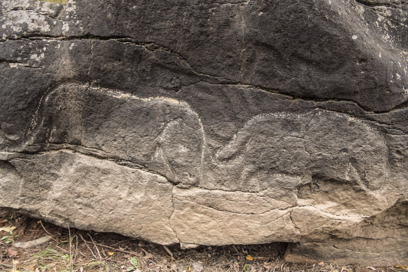
Mammoth Petroglyph, Sikachi-Alyan, Khabarovsk Territory, Russia
We wake to a still, cool autumn morning and get back onto the highway, with the time pressure to reach Magadan playing slightly on my mind. We make one last detour, leaving the highway and heading east on muddy and increasingly rough tracks through the forest used by hunters, until we come across the A375, a half-built road which was planned to reach Nakhodka but sits strangely abandoned and unfinished, abruptly ending somewhere in the wilderness to the south. We head north and in the afternoon reach the Amur in the Nanai village of Sikachi-Alyan where basalt boulders on the riverbank hold petroglyphs which were made as long ago as 11,000 BCE, at the end of the last ice age. These simple stone impressions show shamanic masks and various animals including a pair of mammoths; images made by people who lived at a time when the land bridge with North America was still open. We stop in Khabarovsk to have a shower at Semyon’s, then hit the road with the intention of making some serious progress in the next few days, driving until the early hours when I pull into a truck-stop for a few hours of rest.
Amga River, Verkhnyaya Amga, Sakha Republic, Russia
The following afternoon, after twelve hundred kilometres of backtracking from Khabarovsk, we turn onto the M56, the Lena Highway, where a signpost informs us that we are 3177 kilometres from our destination of Magadan. The road is initially excellent, having been newly paved, but a cold wind is blowing from the north signalling the onset of winter despite being only the first day of October. We camp for the night in a patch of forest of spongy moss dotted lightly dusted with snow, next to a stream whose edges are just starting to freeze over. The following morning we stop briefly in Tynda, a major stop in the BAM, the Baikal Amur Mainline, which has an unusual looking train station whose interior is filled with Socialist-Realist pictures glorifying the ‘heroes’ who built the railway and pioneered new cities for happy Soviet citizens to live happy lives. In reality the line was initially built, like so much in the USSR, by slave labour and the route, which opened in 1991 just months before the Soviet Union collapsed, is basically useless, connecting a few small towns in the middle of this forbidding wilderness, where people have no reason to wish to live.

Lake Tyungyulyu, Tyungyulyu, Sakha Republic, Russia
We spend the day driving north and enter the Sakha Republic, known as Yakutia in Russian, homeland of the animist, Turkic Yakut people. Here we enter real wilderness once more, as the well-graded road crosses range after range of hills and low mountains. A weather front comes in and the snow falls steadily through the afternoon so that by evening, when we reach the gold-mining town of Aldan, we find fifteen centimetres of fresh snow; an early onset of winter even at these latitudes. After supper we push on and I start to feel very comfortable with the new snow tyres; I detect no sliding on the fresh snow and the car feels so perfectly controlled that we maintain a normal speed, parking-up amongst some lorries in a lay-by after midnight. We wake to a scene of real winter, with temperatures down to -20º C as we continue north, crossing the steaming Amga River in which the first patches of winter ice float past. As we drop towards the Lena River the temperature rises back almost to zero and, shortly after passing the one thousand kilometre marker, we glimpse the blue river very briefly, and soon after stop in the town of Nizhny Bestyakh to refuel and buy supplies.

Landscape, near Uolba, Sakha Republic, Russia
Nizhny Bestyakh marks the start of the R504, better known as a the Kolyma Highway, which traverses the final two thousand kilometres of wilderness to Magadan. The quality of the road soon deteriorates, but there is a quite unexpected change in the landscape; the rolling wilderness of low mountains is here replaced by a quite beguiling, wide grassy valley grazed by horses and cattle and dotted by Yakut villages. It comes as quite a surprise to have travelled one thousand kilometres north of the Trans-Siberian Highway and find a bucolic landscape somehow reminiscent of rural Kyrgyzstan and I’m aware of being in a far-flung corner of the Turkic world. The temperature is hovering around zero and overhead is a motionless mackerel sky of altocumulus clouds. The grass is yellow and the scraggly larch trees have already shed their yellow needles, all giving the place a sense of muted beauty and a still, somnolent foreboding in face of the brutal winter which is approaching; a winter which I plan to drive through next year. I have been advised by a Yakut colleague back in Europe not to make camp near settlements due to potentially aggressive local drunks, particularly in the town of Churapcha, which we reach at dusk. The streets of Churapcha are a horrific quagmire of melting permafrost but we manage to find the town’s only alcohol shop, which is fortified like a bank, and pick up beer for the evening. We drive into the night, passing village after village on a rough road until, somewhere after Ytyk-Kyuel, we stop in the dark and make camp in a patch of tussocky grass behind a stand of birch trees.

Aldan River, Khandyga, Sakha Republic, Russia
We awake under the same mackerel sky to a cold, still morning after a peaceful night. Today is the critical point of the trip, for we must cross the Aldan River. This is the key pinch-point of the entire trip, as there is no bridge across the river and once the river starts to freeze, there is a period of several weeks before the ice is strong enough to drive over. After four long days of driving with rather little sleep, we are also ready for a short day in the car. The road soon leaves the grassy valley and cuts through bare larch forest until we emerge overlooking the Aldan at 10:00 and, by a stroke of luck, a ferry is just ready to leave. The river is still ice free and we enjoy a smooth, two hour crossing, driving a little further along the river to reach our destination for the day. Khandyga has a mixed Russian and Yakut population and feels far less wild than anywhere we have recently passed through. We meet my contact Rustam, an ebullient Russian / Tatar lawyer who seems to know everyone in town, guides us to an apartment hotel and later brings us pizza for dinner. Maciej and I greatly enjoy Khandyga, spending a relaxing afternoon meeting the town’s exceptionally friendly inhabitants and enjoying a stunning, very protracted sunset over the Aldan River, again feeling the melancholy of late autumn with the quiescence of nature only broken by the cawing of ravens.

Vostochnaya Khandyga River, Sakha Republic, Russia
On our way out of town the next morning, we meet Rustam in the gently falling snow, which he tells us is unseasonably early, and bid him farewell. We stop briefly in his home-town of Tyopliy Klyuch where there is a small museum about the Kolyma Highway run by very friendly and enthusiastic women who show us the rather poignant exhibits; maps, remains of the tools prisoners would have used to fell trees and construct the road, and an old wooden kilometre marker. It makes us remember the grim human price which was paid to open up this region, with unknown tens or hundreds of thousands of deaths. The very roadbed reputedly incorporates the dead bodies of thousands of prisoners and the road itself might be considered a memorial to Stalin’s unbridled evil. After Tyopliy Klyuch we enter utter wilderness as we track the Vostochnaya Khandyga River, with the road often far above the yawning river valley which seems to exist wholly detached from the intervention of man. I’m quite awestruck by the views, feeling that we are glimpsing the ends of the Earth, a land which exists far, far away from the rest of the world.
Yakutian Horses, near Kyubeme, Sakha Republic, Russia
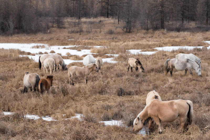
Late in the afternoon we climb a pass in the Verkhoyansk Range which in tectonic terms marks the boundary with the North American continent, emphasising the end-of-the-world feel. We camp in a beautiful, open, snowy forest on top of the pass surrounded by mountains, but I’m disappointed to see that I have a puncture in a rear tyre, which has to be changed in the morning at -13º C. We descend gently into a sweeping plain ringed by mountains, stopping at the lonely fuel station in Kyubeme, the only inhabited building left in the settlement. Here the original Kolyma Highway heads east towards Tomtor, beyond which the road is barely passable, but we take the modern highway which turns north. We spend the day driving through more austerely beautiful scenery, with no sign of human habitation except for the occasional herd of Yakutian horses. Stout, fat and with thick winter coats, these horses have adapted to the extreme cold winters of Yakutia since being introduced by Yakuts migrating from the Baikal region in the thirteenth century. They are bred for their meat in an environment too extreme for sheep or cattle and so are essential to traditional Yakut life.

Arkagala, Magadan Region, Russia
After crossing a pass in the Chersky Range, we stop for fuel and supplies in the rather grim gold-mining town of Ust-Nera and camp a little further east above the Indigirka River, enjoying a long evening of drinking around a roaring fire. Beyond here, the landscape is less dramatic but still vast and untrammelled, as we pass the forlorn town of Artyk and cross into Magadan Region. Here there are some signs of mining activity which gives the impression of entering deeper into ‘Kolyma’, the region named after the Kolyma River, which is synonymous with brutal forced labour camps, murder and death by exhaustion and exposure. We pass a string of abandoned settlements: Ozernoye, Arkagala, Kadykchan; places where from the 1950s onwards free Soviet citizens were lured to live and work with high wages and long holidays. With the collapse of the Soviet system it became far less advantageous to live here and people naturally moved away. Now these towns are shells of concrete apartments, crumbling houses with peeling walls of wood panelling and fields of scrap metal, picked through by scavengers. Just past Kadykchan we are almost startled to see the normally familiar sight of a field of hay bales, and decide to camp in it for the night.
Ayan-Yuryakh Valley, Magadan Region, Russia
It’s snowing again the following morning and soon after starting out we turn off the Kolyma Highway onto a side track known as the Tenkin Route, which cuts through the mountain ranges and is a more direct and more scenic route to Magadan. We carefully negotiate a steep snowy pass, the new winter tyres proving themselves once again, and spend the day driving through a mountainous wilderness, crossing the Ayan-Yuryakh and Kulu Rivers, passing the half-abandoned gold-mining town of Omchak and shortly after, turning off the road. Crossing a small river we pass signs warning of radioactivity and enter a site known as Butugychag; a formerly secret Gulag camp where prisoners were forced to mine uranium from a nearby hillside. To reach the mines on the hillside requires crossing a a river which is now half-frozen and therefore unfortunately impassable for the car. We spend the night near the ruins of old administrative buildings and awake to a gloriously crisp winter morning at a temperature of -23º C. After a leisurely breakfast we carefully cross the river on foot using planks taken from a ruined building and investigate the lower part of the site, where a ruined processing facility bears graffiti dating back as far as the 1960s. From the top floor of the facility we look across the beautiful winter scene to the snow-covered hills in the distance, where we can just make out the old tracks leading to the mine shafts.

Mask of Sorrow, Magadan, Magadan Region, Russia
We camp in the snow for a final night near Madaun, then cross a pass thickly covered in fresh snow in a landscape now almost entirely white, reaching the town of Palatka and rejoining the final section of the Kolyma Highway just before noon. The light traffic on the road marks an end to our wilderness drive, but the conditions become difficult, with heavy snow and white-outs in places. This is the first snow of the season and it has come early, surprising the gritters out of their summer hibernation and catching several drivers unprepared; we see one overturned vehicle in a ditch and later emergency vehicles rushing in the opposite direction. We pass the city limits of Magadan but before entering the city proper, make our way up to a poignant monument; the Mask of Sorrow, which sits overlooking the city. The memorial, constructed in 1996, consists of a large concrete face whose left eye is streaming tears, each of which is in itself an anguished face. Around it are roughly hewn rocks; some engraved with the various religious symbols of those who were swept into the Gulag system, and some carved into the names of various Kolyma camps. It’s one of very few monuments in the country to one of the greatest crimes of the twentieth century, a telling sign of the how the Stalinist period is dealt with in modern Russia. This indeed raises several uneasy thoughts in my mind; Is there really such widespread ignorance of the crimes which took place? Are those who look up to Stalin wilfully ignorant of his crimes, or is there something much darker; a complete suspension of morality for the perceived purpose of patriotism? Will the present Russian government, whose institutions and leaders are descended from the organs who oversaw this atrocity, ever find the courage to publicly renounce Stalin, rather than clinging to his brutality?
Nagaev Bay, Magadan, Magadan Region, Russia
For a place which was called the ‘Gateway to Hell’ by arriving prisoners, who reached the ‘island’ of Kolyma by ship, Magadan looks surprisingly pleasant as we drive in. We make our way to a snowy, rocky beach overlooking Nagaev Bay and the Sea of Okhotsk, marking the end of our journey. For the hundreds of thousands of prisoners who landed here, this must have been a place of despair, but for us it is a place of respectful jubilation, for here we complete our journey; 23,176 kilometres in sixty-one days, crossing very nearly the entirety of Russia. From this slightly bleak, end-of-the world outlook, the first days of the journey in the late summer warmth of European Russia seem very remote in both space and time. Our proposed host Evgeniy is sadly indisposed, as his mother has been involved in a car accident, and we spend a rather tense afternoon trying to find a hostel or apartment without success, and almost resort to another night of camping. Finally however, my contact Oleg finds us a well equipped apartment which we are delighted to take greatly desiring a hot shower after days of winter camping in the wilderness. Over the next two days we wash our equipment and clothes, and I take the car for a deep clean at a local car wash. Here all the dirt, snow and ice from our journey are blasted off, with the car emerging polished and gleaming, cleaner than I have ever seen it. On our final evening, Oleg helps me put the car into a guarded warehouse, from where I will collect it in mid-January.
Together with the apartment owner, who happens to be on the same flight as us, we drive to Sokol Airport and take an eight-hour flight back to Moscow, crossing back eight time zones and thus effectively standing still in time, landing into a damp and warm European autumn. We head straight into town and meet my friend Katerina in a bar just off Red Square. Maciej flies out late in the evening but Katerina and I meet with her friends and stay out until the early morning; something which seems to prevent my feeling any jet-lag. On the morning of the 14th October I take off from Moscow; feeling delighted at having pulled off such a huge trip, enriched with the imagery of driving across an entire continent, slightly odd at leaving the car behind and slightly nervous at the prospect of the return journey in the depths of winter. There is no turning back now.
Stage 43 – Russia & Kazakhstan: Trans-Eurasia [2/3]

Having crossed European Russia and West Siberia, Maciej and I would now embark on the next stage of our route to Magadan; through the mountains, rolling steppe and vast taiga (boreal forest) of southern and eastern Siberia, driving where possible on quiet back-roads and passing through a magnificent and varied landscape as the warmth of summer gave way to the vivid colours and deep blue skies of autumn. Leaving the main Trans-Siberian transport routes, we would come into contact with the indigenous cultures of Siberia; from the intriguing remains of ancient pastoralists to the nomadic Khakass, Tuvans and Buryats, whose cultures are recovering from Soviet repression, and who make up part of the great diversity of Russia’s population. This would be the most the scenic and exotic leg of our Trans-Eurasian journey.

Abakan Range, near Orton, Kemerovo Region, Russia
On the rainy morning of the 2nd September 2017, Maciej and I leave Novokuznetsk, driving east alongside the Tom River on roads blackened with coal dust, to the coal mining town of Mezhdurechensk where the road ends. From here a railway continues eastwards over the mountains of the Abakan Range towards Askiz in the Republic of Khakassia, a journey of 220 kilometres by rail, but well over a thousand kilometres by road, via a circuitous route backtracking far to the north to avoid the mountains entirely. However, from carefully studying satellite maps and high-scale Russian paper maps, I have identified what seems to be a viable track across the mountains via the village of Orton, which we call simply the Orton Route. I know of only one account of someone taking this route and in Novokuznetsk this morning, whilst at a garage having the car’s oil changed, a local had laughed at our chances in anything other than a military truck. When I had remonstrated and pointed out the route on my Russian paper map, he had scoffed and told us: ‘Following maps is how the Germans got stuck in Russia during the war!’

Orton Route, Kemerovo Region, Russia
After topping up with fuel in Mezhdurechensk, we cross the Tom on a narrow pontoon bridge in the village of Mayzas, where I stop to ask a man fixing a lorry at the roadside, who confirms that the road is passable in a 4×4. Encouraged by this news, we head up into the mountains on an excellent, recently graded track with occasional glimpses across a cloud smeared, rolling wilderness of taiga, crossing a pass of around one thousand metres and descending to the village of Orton.
From Orton a narrow track heads east, which we follow for a few kilometres before making camp at a damp but gloriously wild spot on the bank of the Orton River, a tributary of the Tom. It’s very satisfying to take this back-route into the mountains, well away from the traffic of the main Trans-Siberian Highway, and to make use of the car’s off-road abilities instead of driving on smooth asphalt. In the morning we continue, climbing along the Orton, fording the river near a cleared area which was the village of Bolshoy Orton until 2012 when the regional government demolished it. We then follow the Fedorovka River, climbing on a rough forest track with many puddles and frequent, if minor water crossings until we reach a small pass which we presume to be the regional border. We stop here for lunch, enjoying the now sunny and pleasantly warm weather, glad to have made the adventurous crossing of the mountains without any serious challenges, the car having proven itself very capable off-road.

Ovoo, near Vershina Tei, Khakassia Republic, Russia
Once in Khakassia we descend on tracks which are immediately better and more frequently used and soon become wide and well graded, with views once more across the eastern slopes of the Abakan Range. After stopping to buy beer in the mining town of Vershina Tei, we climb another pass, where we find the first indication of having crossed into a new culture, in the form a road-side ovoo. Derived from the Mongol word for pile and usually taking the form of a cairn or stack of logs, an ovoo is a type of altar commonly found in the Turkic-Mongol world and is a place to worship and make offerings to the spirits of a peak or pass, or to the spirits of deceased shamans or elders. This ovoo has a perhaps Russian touch to it, consisting of a decoratively carved wooden pole with a spoked wheel entirely covered in colourful votive prayer rags. The pass also forms the border between the watersheds of the Ob and Yenisei Rivers and so marks our entry into eastern Siberia. We drop into the Askiz Valley, soon stopping to camp in a field surrounded by magnificent, untouched hillsides of mixed forests glowing with the first hints of autumn colour in the warm evening light. It’s a perfect ending to a very memorable day.
Khakas Woman, near Ankhakov, Khakassia Republic, Russia
Descending further the next morning, the Askiz Valley soon opens up into a broad, sweeping grassland fragrant with the smell of wormwood, which instantly recalls to me the wide steppes of Central Asia. Fed by the clear water of the Askiz, the valley is perfect pasture and is dotted with villages of livestock farmers; mostly Russians whose ancestors arrived here as early as the eighteenth century, though many are the descendants of twentieth century forced migrants. It’s no surprise however to find that the valley has long been inhabited by pastoralists and is rich with the relics of its Bronze Age and Iron Age inhabitants. These we find first just outside the village of Kazanovka, where the farmland is dotted with menhirs; large slabs of pink shale, sometimes solitary but often arranged in square arrays which may have been used for ritual purposes, as territorial markers, or as burial complexes. These rather mysterious constructions may be found across Eurasia and were common to many distinct though presumably related cultures. The Bronze Age people who carved these stones here Siberia are thought to have been speakers of early Indo-Iranian languages and it’s intriguing to think that they may have been closely related to the earliest Indo-Aryans, who penetrated the Indian Subcontinent and whose cattle-herding culture formed the basis of the ancient Vedic religion in which Hinduism is rooted. Many of the Bronze Age slabs have been re-used by later peoples such as those of the Tagar Culture who flourished here from the eighth century BCE to the third century CE; a race of settled livestock herders with European facial features.
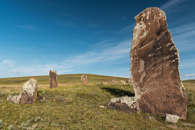
Menhirs, Safronov, Khakassia Republic, Russia
In the small, friendly town of Askiz we reach the A161 and turn south towards Tuva and the Mongolian border. The road follows the Abakan River through more beautiful, watered grasslands with occasional poplar trees dotting the river, and mixed villages of Russians and Khakass. In the late Bronze Age, pastoralist cultures of the Eurasian Steppe such as the Tagar came to be replaced by nomadic horse-men, ushering in a period in Eurasian history of nomadic invasions into ancient centres of settled civilisation; the Xiongnu into China, the Saka into Iran and the Huns into Rome. Here in Khakassia, the Tagars were displaced in around the third century CE by the Yenisei Kyrgyz or Khyagas; Turkic nomads, many of whom would migrate south to become modern Kyrgyz and whose local descendants are known today as the Khakass. We turn off the highway in the late afternoon and drive into the hills immediately above the village of Safronov, camping in an enchanting landscape of rolling grassland hills, backed by low mountains darkened by pine forest. After a beautifully tranquil night, we descend to Safronov’s menhirs; some of the largest in situ menhirs in the region. There are four distinct square-plan complexes, one with a single stone almost five metres in height, richly carved with Iron Age petroglyphs depicting human figures, shamanistic symbols and tribal tamgas. Their silent power, the weight of history which they represent, and their location out in this wonderful, soft landscape, with no fences or even signposts, makes them one of my favourite archaeological sites.
Abakan Valley, Khakassia Republic, Russia
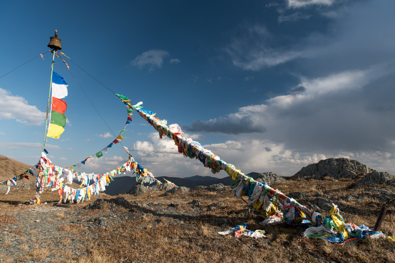
Rejoining the main road, we continue south, with the looming ridges of the Western Sayan Mountains rising on the horizon. We leave the grasslands and enter thickly forested mountains, stopping in the iron-mining town of Abaza to stock up on supplies, then climbing on the almost eerily quiet A161, passing the treeline and stopping on the 2207 m Sayan Pass, the border with the Republic of Tuva. A huge ovoo occupies the roadside on top of the pass; a central mast held by guy cables covered with Buddhist prayer flags which flap furiously in the strong wind. Beyond, darkened in the shadow of brooding clouds are the dark ridges of Tuva, a severely beautiful landscape and a place which fills me with both excitement and a a touch of terror. Back in 2007, on my very first trip to Russia I had entered Tuva on the glorious but tough off-road route from the Altai Republic and found Tuvans with whom I interacted in the west of the republic to be cold, hostile, drunk, aggressive and ultimately violent, leading to two young men attempting to mug me and hurling an apple-sized rock at my truck. Aside from the breathtaking scenery I came away from Tuva with rather negative impressions and so now, looking down once more to the wilds of western Tuva, I am nervous about our safety, but also anxious to have more positive impressions on this second visit.
Sayan Pass (2207 m), Tuva Republic, Russia
We drop into the pristine valley of the Ak-Sug River, which appears to be wholly unpopulated aside from a couple of roadside cafes. The area is said to have been depopulated because of lawlessness and cattle rustling, so we are very careful when picking a place to camp. We spot a track heading down to the river, which is completely concealed from the road by a thick swath of poplar and pine forest and after checking a few kilometres beyond the junction, we double back and slip into the forest, making sure no traffic sees us heading off the road. What we find is actually a most charming spot amongst the trees, next to the rushing cold water of the Ak-Sug were we spend the night completely undisturbed. In the morning we climb out of the forested valley over a small pass and drop into a new landscape, one of much dry steppe; a wide, open landscape very much reminiscent of Mongolia. Here we see our first yurts, known as ög in Tuvan, sitting beyond the calm Alash River in a small herder’s camp. After a lengthy stop at a police checkpost, we proceed across the plain and drop into Tuva’s second city, Ak-Dovurak, which was built up in Soviet times around a large, now barely functioning asbestos mine. There are a few cold stares from idle men, but otherwise Ak-Dovurak seems like a friendly small town, unchanged since Soviet times and populated by slightly rough looking men and astonishingly attractive, lithe young women.

Alash Valley, Tuva Republic, Russia
Tuvans are Turkic nomads who in terms of language and culture are closely related to Mongolians, typically practising Buddhism, though with strong animistic influences. Throughout history the land now known as Tuva has been a fairly marginal part of larger empires; Turkic, Mongol and from the late seventeenth century, Qing Dynasty (Manchu) China. Russian traders, gold-miners and Old Believers began to slowly colonise Tuva in the late nineteenth century and, following a 1911 rebellion against the Qing in China, Tuva sought to be free from Chinese domination, becoming part of Tsarist Russia in 1914. Following brief independence during the Russian Civil War, Tuva was incorporated into the USSR and closed to the outside world. In the Soviet period Tuva was decimated by forced collectivisation and communism, which replaced the age-old nomadic culture with the flawed ideals, corruption and economic incompetence of Marxism-Leninism.

Ustuu-Khuree, Tuva Republic, Russia
Driving out of Ak-Dovurak, we cross the rugged, sere landscapes of central Tuva, passing through the town of Chadan which is renowned for its violent crime rate and stopping at the tranquil Tibetan Buddhist monastery of Ustuu-Khuree. Built in 1905 in the waning years of Qing rule, Ustuu-Khuree was destroyed in 1937 as part of Stalin’s repressions against religion, which also saw much of the Buddhist (and other) clergy murdered or imprisoned. Recently a new temple has been constructed, with tapering, whitewashed walls and a yellow pagoda roof typical of the Tibetan style. The stout, mud-brick foundations of the original remain however, and seem somehow emblematic of the fate of Tuvans under the Soviet system. Detached from their traditional lifestyle with their culture deliberately destroyed, the Tuvans were plunged into poverty, later exacerbated by the collapse of the USSR and their physical and political isolation from the rest of the world. It’s perhaps understandable that there are undertones of aggression towards outsiders amongst the most marginalised elements of the population.

Yenisei Valley, Tuva Republic, Russia
We reach the Tuvan capital, Kyzyl, early in the evening and meet our hosts; Tuvan student Syldys, currently on a break from his studies in Moscow, and his father Mergen. I’ve been a little nervous throughout out journey through western Tuva but upon meeting our host family, I am instantly at ease. We drive together to the eastern edge of the city where the family lives in two comfortable wooden houses. We are fed by Syldys’ mother Sara, then head off with his father into the banya for a very welcome hot soak; the first hot water since leaving Novokuznetsk. Mergen is a retired chief of police and Syldys a student of criminology, so I am keen to relate my experiences in the west of the republic ten years ago. Mergen nods knowingly at the memories which I recall, telling me: ‘In the west the people can be crazy; they drink, smoke marijuana and lose their head. There are no Russians there and its pretty lawless. We are originally from the west of Tuva, but we are also very careful when we go there’. I’m somehow reassured by this; glad that my experiences and impressions were not unreasonable.

Bactrian Camels, Tes Valley, Tuva Republic, Russia
In the morning I collect a pre-arranged border permit from the border guards’ office and drive alone (Maciej’s late application has not been processed), south on the M54 towards the Mongolian border, a road I have wished to drive for many years. I pass through a mesmerising array of Tuvan landscapes, starting in the dry, grassy steppe south of Kyzyl, passing salt-fringed Lake Cheder-Khol, then climbing a ridge of thick forest with glowing yellow-leafed birches contrasting against the dark pines. Descending past the town of Samagaltay I enter a magnificent landscape of dry steppe as I meet the Tes River, which flows through this corner of Tuva from its source across the Mongolian border, to its end point in Lake Uvs, also in Mongolia. The river cuts a swath of greenery across the barren plains, dotted with more birches in riotous autumn colour. The road is perfect highway and practically empty and I cruise down towards the Mongolian border where the scenery becomes yet more spectacular, with dunes on the far side of the river spilling off across the border to distant mountain ranges which Maciej and I had driven through in winter, seven years ago.
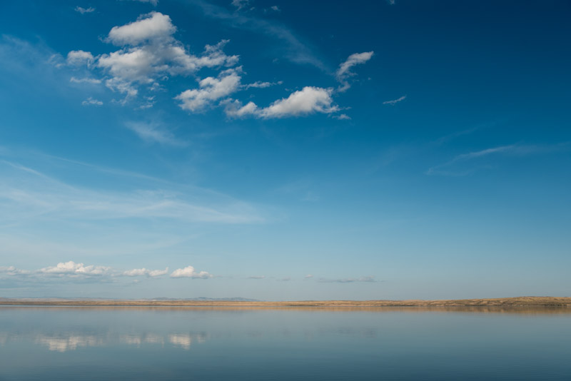
Lake Tore-Khol, Tuva Republic, Russia
I stop at a pack of Bactrian camels, sitting in a tight clump at the roadside. Curious adults leave the pack to get a closer look at me, beautiful creatures in fine health with tall humps covered in ochre-coloured fur, while further back a calf muzzles its mother for milk. It’s a thoroughly stirring vista of high, inner Asia and for a moment I wish I could nip across the border to re-acquaint myself with Mongolia, but sadly the crossing is open only to Russians and Mongolians. The strangely perfect highway ends eleven kilometres from the border, so I turn around, backtracking to the town of Erzin and taking off on sandy tracks across the steppe. I cross the Tes on a concrete bridge and after asking directions from some friendly Tuvan tourists, head down to Lake Tore-Khol which straddles the border. I find a distant spot on the lake’s western edge and stop to camp for the night. The lake’s glossy, almost motionless water reflects perfectly the deep blue sky above me, with the golden sand dunes of the Tes Valley reduced to a thin line on the lake’s far shore. I am absolutely alone here and the area is totally silent apart from a distant flock of geese whose calls float gently across the lake’s surface. This ambience and stupendous scenery evoke in me a quite overwhelming sense of awe in the beauty of this planet and the grace of the natural world; my original and still primal motivation for travelling. It’s little wonder that the Tuvans, living in such a rich natural environment, retain their animistic traditions, offering prayers to the spirits of the mountains, rivers, trees, lakes, rocks, and see no boundary between human, animal and the inanimate, all being infused with the primal dynamism of the universe.

Wooden House, Shiryshtyk, Krasnoyarsk Territory, Russia
After a thoroughly regenerative night camping at the lakeside, I return to Kyzyl where we say our goodbyes to Syldys and his parents, and drive north on the M54. As we cross the Turan Plain and climb out of Tuva, I’m in high spirits. In addition to being thoroughly enchanted by Tuva’s gorgeous and ever-changing landscapes, this visit has reversed my negative impressions of Tuvan people; through meeting Syldys and his family, and through interacting with friendly, civil Tuvans in the east of the republic. It would be tempting to spend weeks slowly touring the republic, but I must keep in mind our ultimate goal; Magadan, still very far away. In the late afternoon we pass the dramatic, horned peaks of the Ergaki Mountains which unfortunately are mostly shrouded in cloud, then turn off the highway in Tanzybey and camp in a forest clearing. Now well out of Tuva, we are in an area of Russian settlements, with pretty wooden houses with coloured window-frames and kitchen gardens behind painted picket fences. Beyond the villages are large arable fields and a striking preponderance of mature, flowering cannabis plants growing along the roadside; something which might explain the rainbow-coloured local bus shelters. We spend the day on very quiet back-roads tracking north-eastwards towards the main Trans-Siberian Highway, nearly running out of fuel but joining the M53 in the afternoon without a problem. It’s almost one thousand kilometres, a distance which takes us a day and a half, heading south-eastwards through taiga and then farmland, passing the unappealing cities of Kansk and Tulun to Irkutsk, the largest city in eastern Siberia.
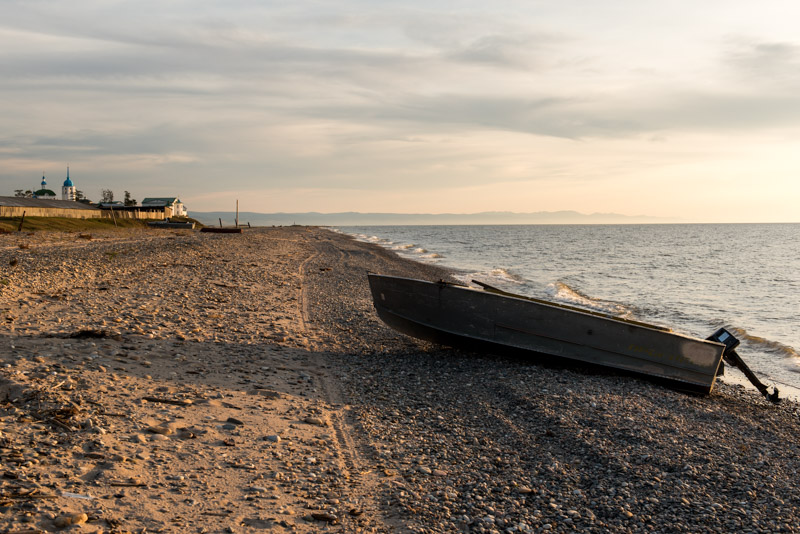
Lake Baikal, Posolskoye, Buryatia Republic, Russia
We spend an afternoon in Irkutsk and stay overnight with Nadia, a Buryat originally from further north in the province, who is about to relocate to Moscow, but we are falling behind our schedule and so, with plans to visit the city again next year, I make the decision to push on. Back on the highway, progress is slow as we negotiate the fringes of the Eastern Sayan Mountains overlooking Lake Baikal, not made any better by the region’s appalling drivers, the worst I have encountered anywhere in Russia. As we cross into the Republic of Buryatia, the traffic eases and we stop in Tankhoy to stand on the lake shore. A squall is coming in off the lake and the thrashing, steely-blue waters look very much like the sea, though the impression is somewhat odd as the drinkably clean lake water has no hint of a salty tang. By late afternoon we enter the swampy delta of the Selenga River and watch a glorious lakeside sunset from the village of Posolskoye, highlighting the spires of the village’s monastery and silhouetting a beached fleet of fishing boats against a deep red sky.

Gandan Darzhalin Monastery, Shuluta, Buryatia Republic, Russia
Long before the Trans-Siberian Railway, Posolskoye was the choice of landing point on Baikal’s eastern shore, and it was here that in 1651 Yerofey Zabolotsky, an envoy to the Mongols from the Russian crown, was murdered by local raiders. Thirty years later, the Holy Transfiguration Monastery was founded on the spot and while Posolskoye (the name deriving from the Russian for ambassador, posol) is now a sleepy village bypassed by all modern transport links, the large monastery remains. We enter the monastery grounds in the morning and are met by Nikolai, a priest with cropped hair, thick glasses and a mouth of gold crowns, who energetically shows us his well tended flower-garden and a simple ossuary where the skulls of former priests sit on an empty shelf. It’s a lovely spot, looking out over the vastness of Baikal.
We continue through the parkland and quaint villages of the delta, returning to the busy main highway only to drive to Ulan Ude, where after navigating the city’s rather arcane Soviet road network, we leave to take another back-road into the Uda Valley, a detour that will bring us to Chita without further using the M55. Leaving the environs of Ulan Ude, we enter a broad, beautiful valley of yellowing grass lined by distant forested ridges and an enormous blue sky. We turn off the road, driving to the village of Shuluta to visit the Gandan Darzhalin datsan or monastery, one of Buryatia’s few Buddhist monasteries to have survived the Soviet period which sits below a grassy hillside.
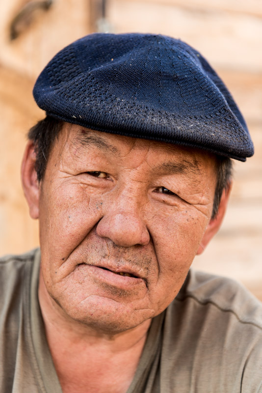
Buryat Man, Shuluta, Buryatia Republic, Russia
The Buryats are the major northern sub-group of the Mongols who inhabit the forested valleys east and west of Lake Baikal. Traditionally shamanistic, Buddhism spread among the Buryats from Mongolia in the seventeenth and eighteenth centuries, though it often came to coexist with, rather than replace, shamanistic beliefs. Russia formally annexed these territories in the seventeenth century, but it was only in Soviet times that the Buryats and their culture were repressed. Under Stalin tens of thousands of Buryats were murdered in an uprising against collectivisation and by the end of the 1930s the majority of monasteries had been closed and destroyed and the clergy murdered. Buryats to the west of Baikal have been strongly Russified, with some becoming Christians, but here, in the beautiful valleys beyond the lake’s eastern shore, the old traditions are slowly returning. Shuluta’s original datsan has survived Stalin’s Great Purge, though it is a formless shell awaiting restoration, but on a rise above it sits a beautiful, modern wooden temple, built in the Tibetan style and surrounded by a wooden fence hung with fluttering prayer flags. Just next to the temple is an unusual construction of multiple poplar sticks arrayed in a cross; a newly built ovoo hung with prayer rags in offering to the spirits that inhabit the place. There’s little activity in the temple, but we get chatting to a Buryat carpenter who tells us a little about the place, then takes Maciej’s palm and reads his fortune.
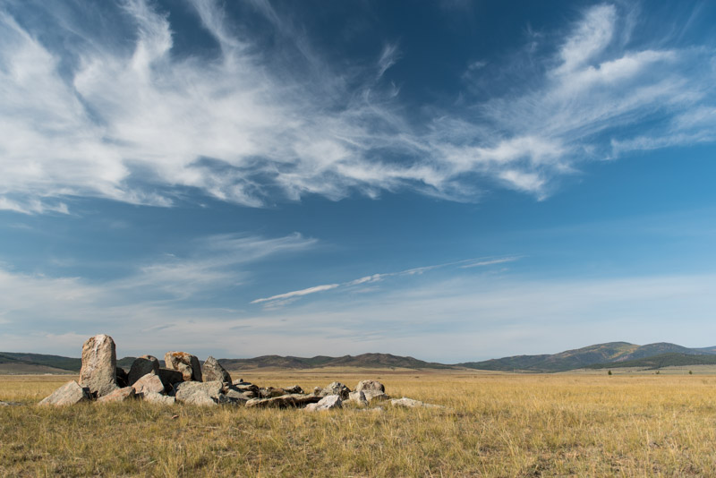
Uda Valley, Buryatia Republic, Russia
As we head deeper into the sun-drenched Uda Valley it becomes subtly more beautiful; the colours more vivid and autumnal, the settlements more widely spaced and the huge sky a gently deepening cerulean. At sunset the air is still warm and we stop to camp on top of a hill overlooking the valley, watching farmers cut the long, yellow grass in preparation for winter and hearing the distant singing of a cowherd following his cows back to a tiny nearby village; another lovely spot. We start at dawn the following morning in order to try to make up some time, but the road deteriorates to a rutted, unsurfaced track as we leave the beautiful valley and enter the taiga which here is being felled by most likely illegal logging companies to supply the nearby Chinese market. The bad road, dull scenery and my concerns at losing time make for a rather less than pleasant drive, but crossing out of Buryatia we encounter good asphalt once more and later, just north of the city of Chita, we join the M58, the highway which will take us eastwards to Khabarovsk.

Shilka Valley, Zabaikal Territory, Russia
We bypass Chita and enjoy the good asphalt of the highway, passing through taiga for two hundred kilometres before turning off the into the wide Shilka Valley, filled with gently rolling grassy hills. We camp for the night in a hillside meadow, watching a beautiful sunset over the gentle undulations of the wide, grassy valley, though we are slightly disturbed in the early hours by some nearby hunters in a Lada Niva shining spot-lights at us and later firing shots in the distance. In the morning we move off, soon reaching the banks of the Nercha River which marks the most easterly point I have ever visited; for me, the trip from here on is entirely breaking new ground. Across the river is the city of Nerchinsk, our last stop in eastern Siberia before the long journey into the Russian Far East. On first sight a slightly shabby, quiet country town, Nerchinsk is in fact of great historic importance and we head straight into the local museum as soon as it opens.

Butin Palace, Nerchinsk, Zabaikal Territory, Russia
This far flung and very sparsely populated edge of eastern Siberia was one of the last parts of Asia to be formally added to what is now Russia, by a set of treaties with Qing Dynasty China. The first of these treaties, the Treaty of Nerchinsk, was signed here in 1689 and formalised the border along the Argun River up until its juncture with the Shilka, where the two become the Amur. Beyond this, the border followed the Stanovoy Mountains in attempt to keep Cossack freebooters out of the Amur Basin. Having formalised the border, Nerchinsk became the chief centre of trade between Russia and China, until 1728 when trade was diverted through Kyakhta far to the west. Nevertheless, Nerchinsk continued to flourish, now on gold mining, using mostly exiles for labour. It is in fact in part of the palace of the local gold magnate Butin Family that the museum is now housed complete with the lavish nineteenth century furnishings. Among elegant chandeliers and gilded stucco mouldings are what at the time were reputedly the world’s largest mirrors, transported from Paris via the Pacific and Amur River to this wild outpost of eastern Siberia. It is indeed quite surreal to step from this Neoclassical refinement onto the streets of the lethargic town, which has other signs of long-past prosperity; some dank, crumbling trading arches, a boarded-up nineteenth century market and a red-brick structure overlooking the river which once received the town’s wine supply, but is now a shabby trade emporium.
Nerchinsk is for us the last point of interest in eastern Siberia; beyond this lie more than a thousand kilometres of wilderness until we reach the city of Blagoveshchensk on the Amur River. We rejoin the M58 and begin the long journey on a perfect asphalt highway, one notable infrastructure project of modern Russia, for in Soviet times there was simply no road, with vehicles being loaded onto the train between nearby Chernyshevsk and Yerofey Pavlovich in Amur Region. It’s a joy to be able to make good progress with no distractions, looking out into the endless taiga which surrounds us on both sides as we round the northern-most bulge of Manchuria in China. Late in the afternoon we cross an administrative boundary into Amur Region, entering the Russian Far East and stopping to camp in a forest clearing.
