
Stage 43 – Russia & Kazakhstan: Trans-Eurasia [1/3]

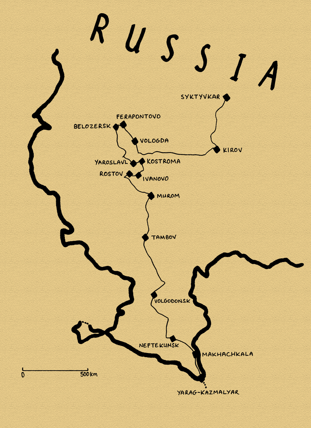
During my 2015 journey to the north of European Russia, I had sketched out an idea for a very ambitious future trip, right across Russia from Magadan on the Pacific coast back to Europe in the depths of winter, satisfying a long-time desire to visit the world’s coldest inhabited areas and explore the Russian north on winter-only roads. Returning to my relatively new, settled life in July 2015 in a charmless corner of North-western Europe, I would find that what had once seemed like an exciting opportunity would pan out to be a disappointing career in an industry witnessing its largest crash in history. However, the extensive planning and preparation for this winter trip would give me something firm and positive to focus on, working towards an expedition which few had attempted. Preparations began in November 2015 with the purchase of a second vehicle, a Toyota Hilux Surf 4×4 with a petrol engine and manual transmission. The vehicle required such extensive mechanical repair and preparation that a proposed departure date of August 2016 had to be delayed by a year, as I spent weekends in the garage ensuring the vehicle would be mechanically fit for such a testing trip.
In the early stages of planning I had dismissed the idea of shipping the vehicle straight to the start point of Magadan and so there would be an outward, eastward journey across Russia in 2017, finishing just before the winter set in. This transcontinental journey would be a fast-paced road-trip, crossing very nearly all of Russia; from its European west, across the Urals, the lowlands of West Siberia, the mountainous republics of southern Siberia, wild taiga of eastern Siberia, and on into the Russian Far East. At the Pacific coast I would turn around, heading north into the wilderness for the long journey to Magadan where the Hilux Surf would be put into storage in preparation for departure in January 2018.
Finally setting off after work on the afternoon of the 11th August, I drove overnight to Gdansk in Poland where I met my friend Maciej who would accompany on the eastward trip. Together we would make a very memorable journey across the vast and subtly changing landscape of Russia, starting in the sweltering days of late summer and ending in the opening stages of a brutal winter. Nine weeks and more than 23,000 kilometres driving Trans-Eurasia.

Baltic Coast, Zelenogradsk, Kaliningrad Region, Russia
It’s the afternoon of the 13th August 2017, and Maciej and I enter Russia’s exclave Kaliningrad Region, taking our fist steps into Russia on the long road to Magadan. Leaving the border town of Mamonovo we make a side trip up to the ruined red-brick fortress of Balga, a medieval castle of the Teutonic Knights which has long been in ruin, though was heavily damaged in the Second World War when it was the site of one of the Red Army’s final battles with the Wehrmacht. Today the castle is a sad ruin in the midsts of being reclaimed by the forest, with clumps of its exploded masonry lying on the wild shore of the Vistula Lagoon. Returning to the main road just before sunset, we strike our first camp in a large fallow field surrounded by a tall, natural perimeter of trees. After years of preparation I’m thrilled to be on the road at last, enjoying life with thoughts of work well out of my mind, though this idyll is almost broken when my camping stove bursts into flame on first use.

Dancing Forest, Kaliningrad Region, Russia
In the morning we pass straight through the city of Kaliningrad, stopping in Zelenogradsk on the wind-swept Baltic coast. Once known by its German name of Cranz, Zelenogradsk is a faded nineteenth century resort, an odd mix of Germany and Russia with an air of what I imagine might still be post-war dereliction and depopulation; the same impression that I had in 2010 on my previous visit to this intriguing spoil-of-war territory. We leave on a small road heading out onto the Curonian Spit; a long finger of land which stretches over into Lithuania. In contrast to the general scruffiness of the ‘mainland’, the spit is a beautiful stretch of wilderness, thickly forested with occasional bare slopes of sand dunes. It’s popular with tourists from Russia and the Baltic States, but still a pleasant place to spend an afternoon, seeing the ‘Dancing Forest’, a patch of strangely twisted pine trees, walking through another stand of forest to the tranquil Curonian Lagoon, or watching the breakers wash onto fine, sandy Baltic beaches. Late in the afternoon we enter Lithuania through a quiet border crossing, driving north to catch a ferry back to Klaipėda on the mainland.

Izborsk Fortress, Izborsk, Pskov Region, Russia
We drive the next day through Lithuania into Latvia, passing through Riga then heading across the country, cutting through the very south-eastern corner of Estonia to cross into Russia at the border crossing of Shumilkino, where I had finished my 2015 trip. One of the immigration officers asks me my destination in Russia. ‘Magadan’ I tell him. He looks at me for a second, then warns me that Magadan is a Gulag. ‘All Russia is a Gulag’ adds a young colleague sardonically. Now in Russia proper, we truly set off on the road to Magadan. It’s a beautiful, warm summer evening and we soon stop in Izborsk to visit the town’s fourteenth century stone fortress, one of Russia’s oldest, which sits on grassy rise, beautifully illuminated by the soft evening light. Legend tells that in the ninth century Izborsk was the seat of Truvor, brother of Rurik, founder of the dynasty that would govern Russia until the seventeenth century and, as we listen to the gentle sounds of village life floating in the warm evening air, we tell ourselves that we are really in Russia.
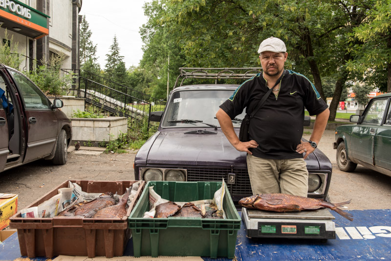
Fish Seller, Pskov, Pskov Region, Russia
It’s after dark by the time we reach Pskov, a city I have twice passed through without stopping and am keen to properly visit. Pskov is one of Russia’s oldest cities, first being mentioned early in the tenth century and was initially part of the Novgorod Republic, then independent, before being incorporated into the Grand Duchy of Moscow. Traditionally a border city, Pskov grew rich on trade but its fortunes waned when Peter the Great pushed the border of Russia westward in the eighteenth century, roughly to its current location.
Maciej and I are hosted by Vladimir and his wife Rita, who live in a Soviet apartment complex on Pskov’s main Rizhsky Prospekt (Riga Prospect) on the city’s western edge. A computer programmer, Vladimir also describes himself as a social activist and tells us that he was threatened with legal action from the authorities in his previous home in Moscow, for reasons he does not elaborate on, and now keeps a low profile in this relative backwater. As Maciej and I leave his apartment the next morning to spend the day in the city, Vladimir is out watering some saplings which he has recently planted outside his home, trying to take the edge off the brutal Soviet concrete gigantism.

Krom, Pskov, Pskov Region, Russia
Pskov indeed comes across as a slightly down-at-heel place, the capital of one of Russia’s poorest regions. Happily, this seems to have largely spared it from the ugly rash of modern development, which together with the friendly nature of local people give it a pleasant, provincial air. As we reach the banks of the Belaya River however, we see Pskov’s magnificent ancient centre, which spreads around the imposing fifteenth century Krom, or fortress. This beautiful landmark is one of the finest pieces of medieval Russian architecture I have seen, sitting above the calm river with large, red letters spelling out ‘Russia starts here’ on the bank. Crossing the river, we enter a centre of shady parks and countless small churches, albeit above the dust, noise and fumes of modern traffic. South of the centre is the serene Mirozhsky Monastery, whose twelfth century Transfiguration Cathedral is a rare pre-Mongol building and contains beautiful frescoes showing the life of Christ with clear Byzantine influences. We end our tour of the city drinking beers in the evening warmth on the riverbank overlooking the Krom, delighted at the prospect of a journey across the world’s largest country.

Source of the Volga, Volgoverkhovye, Tver Region, Russia
We leave Pskov in the morning of a sultry, late-summer day and head north-eastwards on a pleasant country road, passing the coffee-brown waters of Lake Ilmen and the ancient town of Staraya Russa, once a summer home of Dostoyevsky but which today looks rather run-down and seedy. We turn south-eastwards onto unpaved roads, heading for the Valdai Hills, an upland of thick forest, swamps and lakes which form the highest point of the huge East European Plain. Out here the villages are isolated and rather idle; stopping in one we attract a group of friendly drunks who talk to us; one stumbling, punch-drunk man tells me he has a sister living in the UK, before asking for fifteen roubles to help him buy a bottle of port-wine. We cross into Tver Region in the evening and make camp in a small forest clearing next to a beautiful lilly-filled pond. As we sit inside the car drinking beer, taking refuge from the mosquitoes, we are jolted by a loud explosion. Far too powerful to be a gunshot, I guess it might be locals dynamite fishing in these remote backwoods.
We leave at dawn the following morning and just after sunrise reach the tiny village of Volgoverkhovye. Here, in a small, tranquil bog on the edge of a stand of birch forest, alive with the sound of chirping frogs and buzzing insects, the Volga rises and begins its journey to the Caspian Sea. The bog drains through a stand of water hyacinths into a tiny stream and it is quite mind boggling to think that this is Europe’s longest river, in places so wide that one cannot see from one bank to the other; the backbone of European Russia, flowing south-eastwards almost to the borders of Asia.
Transfiguration Church, Krasnoye, Tver Region, Russia
We spend the day driving east towards the capital, passing Ostashkov and Torzhok, then getting lost on small country roads which end in forlorn villages, eventually finding a route to the tiny village of Krasnoye. Here we find the astounding Transfiguration Church, a pink piece of Gothic Revival of very unusual proportions; a circular plan with four subsidiary circular apses, all covered in narrow, white vertical bands. The church is a copy of the Chesme Church in Saint Petersburg, commissioned by Catherine the Great to commemorate Russia’s victory over the Turks at the Battle of Chesme in 1770 and is utterly at odds with the simple village scenes which unfold around it. Approaching the church we are given a tour by a tall, thin, greying but energetic woman, the mother of the local priest. She explains how a Mr Poloratsky, the local landowner, built the church for Catherine the Great in 1790, anticipating her visit. Sadly, after receiving what she considered an unsatisfactory welcome en route, the empress returned to Saint Petersburg and never saw Krasnoye’s church. This incongruous structure survives today as a mere memory of the Russia of old; the wealthy class of feudal landlords whose estates covered the rolling farmland of European Russia.
In nearby Rzhev, we cross the Volga once again, here already a sizeable river almost one hundred metres wide, then enter modern Russia in the form of the furious Moscow-bound traffic of the M9 Highway. As we approach the capital, this becomes a much-needed motorway, a rare improvement of inadequate Soviet infrastructure. We get caught in gridlock on the edge of Moscow, and it’s not until after dark that we reach Podolsk, where we are hosted by my friend Katerina in her parents’ comfortable self-built house.

Sviyazhsk Fortress, Tatarstan Republic, Russia
It’s nice to see Katerina again and tempting to stay for a day, but we must push on and so join the infamous MKAD, or Moscow ring road, where Saturday traffic is heavy but generally free-flowing. However, as we approach the M7 junction, roadworks cause traffic to snarl up and we barely move for an hour, reminding me of the hours I spent near here trying to leave Moscow on my first visit to Russia in 2007. Despite having driven several times in Tehran, Karachi and Istanbul, nothing in my experience compares to the gridlock of Moscow’s overwhelmed road system. Traffic remains heavy well out of the city and we soon see a four-car pile up happen right in front of us. After more than two hours the traffic starts to clear, but it is not until the afternoon that we feel to have escaped the grip of Russia’s unlovable capital. We continue east, driving into the night and stopping late to camp in a field. Waking up to a beautiful morning and the sight of low, rolling hills on the horizon, we make a short side-trip to the Volga and the fortress of Sviyazhsk, located on a hill now almost surrounded by the waters of the Kuybyshev Reservoir. It was from here that Ivan The Terrible launched his final siege against the Khanate of Kazan in 1552, a crucial step in the Russian subjugation of the Tatars, descendants of the hated Golden Horde. The fortress is teeming with Sunday tourists though this does little to detract from the dramatic setting overlooking the now very mighty Volga.

Cathedral Mosque, Bolgar, Tatarstan Republic, Russia
We turn south, missing Kazan and leaving the M7, driving through the rolling fields of Tatarstan and notice a gentle cultural change with the appearance of mosques in the towns and villages, bilingual Russian and Tatar road signs and a more noticeable police presence. We end another long, hot day camping in a field having failed to find a suitable spot on the Volga. In the morning we pass through the northern edge of Ulyanovsk and cross the Volga on the new and very impressive President’s Bridge which runs for almost six kilometres over the vast river. This central Volga region of Russia, with prosperous industrial cities, friendly locals and beautiful rolling landscapes is perhaps my favourite part of European Russia and it’s tempting to continue downstream towards Tolyatti and Samara, but we turn northwards, doubling back into Tatarstan. We drive on a quiet country road through fields of dazzling sunflowers, freshly baled hay and neat Tatar villages, stopping in the town of Bolgar in the afternoon.
Bolgar was the capital of Volga Bulgaria, a state formed by groups of descendants from Old Great Bulgaria (as were the Bulgars who moved west to become the ancestors of modern Bulgarians) which was destroyed by the Khazars in the seventh century. Sitting astride the Volga, then a trade route for the transport principally of furs from Europe to Asia, Volga Bulgaria flourished. Decline began with frequent raids by Russians of Novgorod and Vladimir-Suzdal early in the thirteenth century and soon after, in 1236, Volga Bulgaria was overrun by the Golden Horde. The Volga Bulgars, themselves of nomadic Turkic stock, integrated with the invading Mongols and Bolgar became a very wealthy city. When the Golden Horde split into Tatar Khanates around the turn of the fourteenth and fifteenth centuries, the Khanate of Kazan came to occupy an area similar to that of Volga Bulgaria, and whilst the capital was now in Kazan, Bolgar remained an important fortress city.

Volga River, Bolgar, Tatarstan Republic, Russia
Bolgar is beautifully situated above the widest part of the Kuybyshev Reservoir, the largest in Europe, where the Volga resembles an inland sea. The museum complex consists of several mausoleums dating to the thirteenth or fourteenth centuries, the ruined walls of what is called a Cathedral Mosque, two reconstructed minarets and the very faint remains of the Khan’s Palace. Much of it is rather obviously restored and only the fourteenth century ‘Black Chamber’ retains much of its original form, with clear influences from Central Asian funerary architecture. The function of the building is unknown, but legend tells that the Khan’s family hid here from Tamerlane in 1396 who blackened the building by setting fires against it. The cultural significance of Bolgar is also interesting, as something of a cultural homeland for the Tatars, Russia’s largest non-Slavic and Muslim minority, whose culture is slowly re-emerging after decades of Soviet repression. Indeed, in Soviet times, Bolgar became a secretive place of hajj in place of Mecca. Compared to the legacy of the Ilkhans in Iran, the Golden Horde left very little physical evidence and so Bolgar is altogether quite fascinating, though any direct link between the Kazan Tatars and the earlier Volga Bulgars remains to be proven.

Izhevsk Pond, Izhevsk, Udmurtia Republic, Russia
From the beautiful summer landscapes of southern Tatarstan we head north the next morning towards the Kama River, the largest tributary of the Volga, passing through the noxious industrial city of Nizhnekamsk. The jaundiced light, fumes and broken roads of the petrochemical city are a far cry from the bucolic landscapes to the south, but it is heavy industry such as this which makes the republic one of the most economically developed regions of Russia. On the north bank of the Kama we stop in the pleasant town of Yelabuga where the sentinel ‘Devil’s Tower’ overlooks the broad river, remains of a supposedly tenth century Volga Bulgarian border fortress.
From Yelabuga we leave the Volga region and head north into the outliers of the Urals, crossing into the Udmurtia Republic and making a brief stop in its capital, Izhevsk. Once Ivan The Terrible had defeated the Tatars, the Tsardom of Russia rapidly expanded eastwards into the Urals, an area long inhabited by various Finno-Ugric tribes such as the Udmurts. Initially a staging post in the conquest of Siberia, the Ural region was heavily settled from the eighteenth century onwards with the onset of large-scale extraction of the Urals’ mineral resources. Izhevsk is exactly this; an industrial city which looks to have changed little since the Soviet period, dotted with smoking chimneys and a rather noxious looking city pond on which residents pedal pleasure boats on this sultry afternoon.
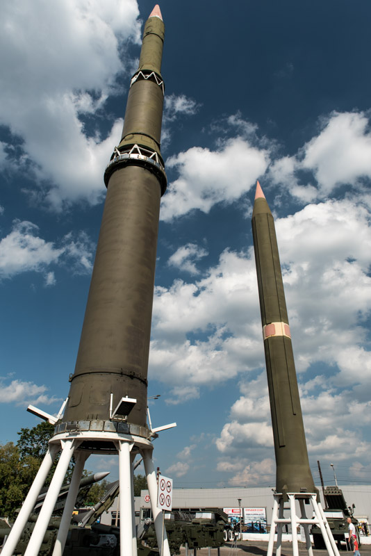
Motovilkha Museum, Perm, Perm Territory, Russia
Leaving Izhevsk, we pass through rural Udmurtia, noticing another subtle change in the landscape as stands of pine forest, the outliers of the great northern taiga appear, and villages become smaller, linear settlements of wooden houses with coloured window frames. We slowly climb over an undulating landscape, watching a hazy sunset over the unfolding ridges, arriving after dark in Perm.
Like Izhevsk, the city of Perm was founded during the reign of Peter The Great as a factory city and would grow into a major industrial hub during Soviet times. Perm became a centre for weapons manufacture and would become a closed city during the Cold War, though today, with a population hovering around one million, it is a thriving Russian city. We are hosted by Vanya and Irina, a young local couple. Vanya drives us into town in the morning and we begin a lengthy walk around the city, whose centre is developed very much in the Soviet gigantic style. We meet with Vanya again for lunch and afterwards visit a small open air museum of the Motovilkha Arms Factory, where Cold War-era ICBMs and launchers are on display. Irina, Vanya’s elfin girlfriend works for Motovilkha designing components for aircraft engines, though she does not have clearance to know what these components are used to build. It’s perhaps not surprising that this arms city is busy and prosperous; throughout the turmoil of the Soviet collapse and recent crashes in commodity prices, the Russians Arms industry was one of the few parts of the country which was kept relatively healthy, vital for defence purposes as well as a source of foreign hard currency. In the evening we take a walk around the centre with Vanya and Irina. Vanya explains that whilst Perm was in the recent past a rather gritty place, today it is one of Russia’s more progressive cities, and we can see plenty of modern small businesses run by young entrepreneurs. We finish the evening in a smart restaurant serving dishes supposedly inspired by the cuisine of the indigenous Permyak people, stopping off at a craft beer shop on the way home for some excellent local IPA.

Perm-36 Concentration Camp, Kuchino, Perm Territory, Russia
East of Perm the Urals build into low, thickly forested ridges amidst which we stop to visit one of Russia’s most unusual museums. In the tiny village of Kuchino is a facility which was known simply as Perm-36 (a code name to keep its real location secret), which served as a prison camp from 1946 until 1987, well into the Gorbachev-era. Perm-36 began as a logging camp in Stalin’s brutal Gulag network which was conceived to provide slave labour for the rapid industrialisation of the Soviet Union and cow ‘free’ Soviet citizens into a state of terror. Perm-36 survived the dissolution of the Gulag network upon Stalin’s death in the 1950s, becoming a maximum security prison camp for the regime’s most difficult political prisoners, some of whom were locked in twenty-four hour isolation. Perm-36 is the only such camp which has remained preserved as a museum, though rather disturbingly it has recently been subject to state harassment, with the authorities censoring some references to Stalin and Soviet leaders. We are given a short tour of the facility, which preserves the multiple barbed wire perimeter fences, a guard tower and most chillingly, the cold, concrete isolation cells where prisoners of conscience were held well into my lifetime. The Gulag represents one of the darkest sides of the twentieth century and I find it rather disturbing that resurgent, chest pounding Russian nationalism from government channels seeks to bury this history.
Bell Tower, Solikamsk, Perm Territory, Russia
In the nearby town of Chusovoy we turn north, driving through often rather grim industrial towns which are juxtaposed upon the beautiful wilderness of the North Urals. In the afternoon we stop in the salt mining town of Solikamsk which, beyond grim piles of salt tailings and rusting, derelict-looking infrastructure, reveals an ancient centre unexpectedly filled with seventeenth and eighteenth century churches. Solikamsk is one of the oldest towns in the region and was once the largest industrial city of Russia, with salt having been mined here since the fifteenth century, long pre-dating the industrialisation of cities such as Perm. The city is also important for having been the western end of the Babinov Route, the first practicable overland route across the Urals, which was established in 1597 and remained in use until the opening of the Siberian Route, much further to the south, in 1735. It was the Babinov Route that allowed Russia (using Cossack mercenaries and funding from the Stroganov Family) to rapidly expand into Siberia, thus becoming the enormous, resource-rich country that it is today. Sadly the Babinov Route has long since fallen out of repair and is impassable to vehicular traffic, so we must content ourselves with the view of Solikamsk’s 1713 Bell Tower, which once marked the route’s starting point. Solikamsk also seems to have fallen on hard times; whilst the town’s mines are working, the general atmosphere is rather less than friendly with hard-faced, thuggish looking men and women, drinking and arguing in the streets. We’re both pleased to leave what is perhaps my least favourite Russian city.

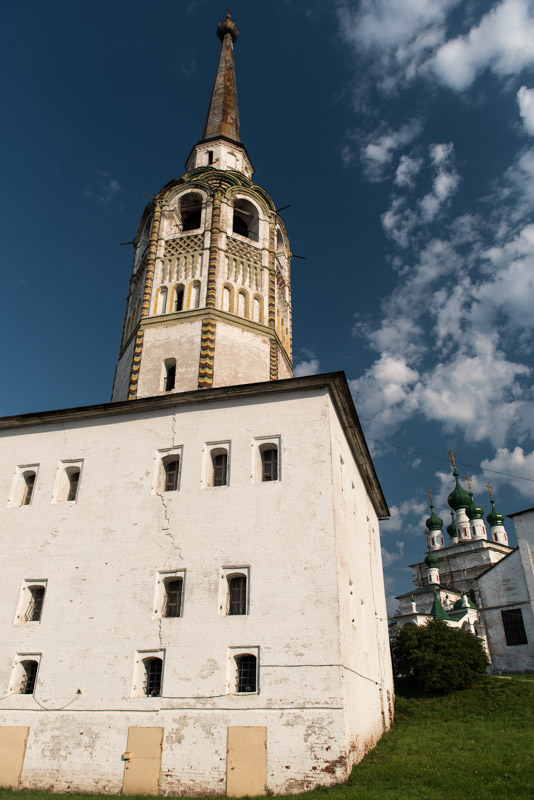
Verkhoturye, Sverdlovsk Region, Russia
After backtracking to Chusovoy we turn east onto a modern, paved road, the most northerly road across the Urals which is open to the public. On a gentle ridge just over 450 metres above sea level, we pass a whitewashed marker announcing that we have crossed from Europe to Asia; a singularly unremarkable transition which merely highlights the absurdity of this notional continental boundary. We make a detour to the north to visit the town Verkhoturye, which was established in 1598 as an ostrog (wooden fort) on the Tura River and marked the eastern end of the Babinov Route; the gateway to Siberia. In stark contrast to Solikamsk, Verkhoturye is a truly beguiling place, feeling like a large village, centred on the slow Tura River, overlooked by a small whitewashed kremlin (fortress) and the soaring towers of the eighteenth century Trinity Cathedral. On this warm summer’s day, Verkhoturye presents a quite idyllic scene from bygone Russian, with children playing in the shallow Tura beneath a wooden footbridge which connects the town’s compact centre with the colourful wooden cottages on the south bank, with almost no Soviet concrete in sight. I leave Verkhoturye thinking I have found my favourite small town in Russia.

Passage, Irbit, Sverdlovsk Region, Russia
We drive south towards Yekaterinburg then east, back onto small roads which take us out of the last ripples of the Urals. Here we enter the West Siberian Plain, the world’s largest lowland, and stop to camp for the night in a fallow field surrounded by stands of birch forest; a quintessentially West Siberian landscape. Our next stop, the following morning, is the rather run-down town of Irbit which, despite first appearances, was once perhaps Siberia’s greatest trade centre. Founded in 1631, Irbit soon came to be the location of an fair where the riches of Siberia could be traded. The eighteenth century saw both the signing of the Treaty of Kyakhta, which opened a border post with Manchu China, and the opening of the Siberian Route, a river route which would also become known as the Great Tea Route. Thus Irbit found itself at the centre of a huge annual trade in tea from China and furs from Siberia with manufactured goods from Europe. At the end of the nineteenth century the trade route shifted once more with the opening of the Trans-Siberian Railway far to the south. This, together with the upheavals of the Russian Revolution and Civil War put an end to Irbit’s fortunes; the last Fair was held in 1928, and the town has remained relatively obscure ever since.
Although Irbit today is a scruffy place of damp, peeling nineteenth century buildings and streets with more than the occasional roaming drunk, there are still reminders of its past prosperity. The local museum has some old photos of the city and fair, and an exhibition on the Great Tea Route, but most interesting is the Passage building on the northern edge of the centre. Still a shopping centre today, the Passage was built in 1864 to serve as the fair’s store-front, with the opening of trade announced in the square out in front. Inside is a busy local market laid out on two open floors unlike any other I have seen in Russia, even with its own tea shop; a distant descendant of the old Tea Route.

Irtysh River, Tobolsk, Tyumen Region, Russia
East of Irbit the land becomes wilder and the towns smaller and farther apart as we pass the southern edge of a huge marshland which stretches for hundreds of kilometres to the north. We cross into Tyumen Region, Russia’s richest, and immediately notice an improvement in the infrastructure as we bypass the capital Tyumen and join the heavy traffic of the main road leading north towards Surgut and the centre of Russia’s petroleum industry, via Tobolsk where we stop for the night.
It was in this region in the late fifteenth century that another successor state of the Golden Horde emerged; the Khanate of Sibir, from which the name ‘Siberia’ may well derive. After conquering the Tatars of the Khanate of Kazan in 1552, Ivan The Terrible looked further east and through the Stroganov Family sent Cossacks across the Urals in 1580 to attack Sibir. Yermak Timofeyevich, the Cossack ataman (leader) took the Siberian capital Qashliq, in 1582, though he was killed two years later by a Tatar reprisal. However, his Cossacks went on to seed numerous Siberian cities, the second of these (the first was Tyumen) being Tobolsk, founded in 1587 at the confluence of the Tobol and Irtysh Rivers.

Old City, Tobolsk, Tyumen Region, Russia
We arrive in Tobolsk in the evening and are warmly received by our host Ilya with an excellent meal and home-made hazelnut vodka. Tobolsk is centred around a large and impressive eighteenth century kremlin which overlooks the rest of the city and reflects the fact that it was effectively the capital of Siberia until the late eighteenth century, and remained an important city until the end of the nineteenth when it was bypassed by the Trans Siberian Railway. Away from the kremlin however I am slightly disappointed with Tobolsk; what once must have been a beautiful Old City of traditional wooden houses has been largely displaced by ugly modern buildings or scruffy vacant lots waiting to be ‘developed’ (often after the old houses are burnt down) and the newer parts of town are bland and characterless. Only the mighty Irtysh stands aloof from this, silently slipping off northwards on its way across West Siberia, carving deep, gracious curves into its silty banks. Ilya drives us out of town briefly, slightly upstream on the Irtysh, to the edge of the village of Sibiryak where the ancient Tatar capital of Qashliq once stood. We meet a Kazakh working at a holiday camp who walks us to a viewpoint over the Irtysh and points across an overgrown and inaccessible ravine to a cliff where he tells us the capital once stood, though there is not a single visible trace of anything man made.

Mural, Petropavl, North Kazakhstan Region, Kazakhstan
I leave Maciej briefly in Tobolsk to make a trip down into Kazakhstan while he takes a bus to Omsk where we will meet tomorrow. Crossing the Irtysh, I leave the main highway and head south on an excellent country road, passing through neat, lively Siberian Tatar villages dotted with pretty cottage-like mosques. The region’s hydrocarbon wealth seems to have trickled right down here and it’s very pleasing to see a part of Russia where rural society is in good health, though it makes me reflect wistfully on what Russia could be if it had a better managed economy. I drive straight across the Trans-Siberian Highway and Railway and enter a beautiful landscape of rich, prosperous farmland near Golyshmanovo, which is marked by its towering grain elevator above a busy bread factory. This is the cultivated swath of territory which marks the southern boundary of Siberia, beyond which the fertile forest-steppe gradually blends into dryer, true steppe, roughly demarcating the Kazakhstan border. Joining the M51, the main Soviet-era Trans-Siberian Highway from Chelyabinsk to Novosibirsk, I head east and cross into Kazakhstan late in the afternoon, camping and driving into the regional capital Petropavl the following morning.

M51 Highway, North Kazakhstan Region, Kazakhstan
After crossing the Urals, Russian Cossacks acting on behalf of the Tsar rapidly conquered the forests of Siberia using a network of vast river routes in the sixteenth century. Expanding southwards into the open Kazakh Steppe, populated by war-like tribes, was a more lengthy and hard-won process which began in the eighteenth century using a network of forts. These stretched along a line which became roughly the Russia – Kazakhstan border, and developed into a number of large cities such as Orenburg, Semipalatinsk (now Semey) and Petropavlovsk (Petropavl). Today there is no trace of Petropavlovsk Fort, but Petropavl is a pleasant, if rather dull city of modern Kazakhstan. My impressions are on the one hand of a city rather trapped in time, filled with Soviet touches such as a large, colourful wall-mosaic, or squads of ladies sweeping streets with brooms and whitewashing kerb-stones, but on the other hand of a city witnessing demographic change, as the Kazakh population slowly becomes a majority in a city which in Soviet times was largely Slavic. As I leave the city in the afternoon, I pass a turning to the south which leads to all the exotic yet familiar destinations of Central Asia and must fight a strong urge re-visit them, but I return to the old M51, re-entering Russia and meeting Maciej outside the station in the centre of Omsk in the evening.

Baraba Steppe, near Kormilovka, Omsk Region, Russia
We wake up at our campsite behind a stand of birch trees to a magnificent morning; the deep crystal blue sky seems to glow with late-summer depth, painted with delicate wisps of cirrus hanging still above the quiescent landscape. We spend the entire day driving east on the Trans-Siberian Highway, driving without stopping through the seemingly endless landscape of the Baraba Steppe; fallow, cleared land, rarely farmed, with pockets of birch forest. After six hundred kilometres we reach the edge of Novosibirsk, Siberia’s largest city (and the third largest in Russia overall) crossing the Ob River on a dam, beyond which spreads the shimmering Ob Sea. We stop for the day in Akademgorodok, a detached city district built around Novosibirsk State University, where we are hosted by Ilyas, a Kazakh biologist with whom I stayed for a few days in winter 2010. Ilyas has recently married Nadya, the two having met through their shared love of tea. In the morning before we leave, Maciej and I are treated to a lengthy, almost meditative tea ceremony, based on the Japanese tea tradition, tasting delicately fragrant pu’er tea from one thousand year-old tea trees in Yunnan Province, China.

Lake Tanayevo, Novosibirsk Region, Russia
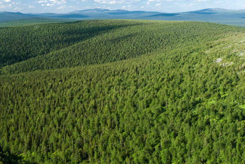
Now east of the Ob River, as we leave Akademgorodok, we leave the West Siberian Plain and climb gently across the Salair Ridge, a low, outlying spur of the Altai Mountains. We descend again past Lake Tanayevo into the Kuznetsk Basin, famed for having some of the world’s most extensive coal deposits. Though settled by Russians since the early seventeenth century, it was only in the 1930s with Stalin’s rapid industrialisation of the USSR that these coal deposits were exploited on a large scale, used principally for the smelting of iron ore mined in the Urals. With this came a great demographic shift as huge numbers of settlers arrived in the region, and it remains the most densely populated region of Siberia. Reaching the rather grim and dirty mining town of Leninsk-Kuznetsky, we turn south onto a broad dual carriageway and by evening reach the region’s largest and oldest city, Novokuznetsk.
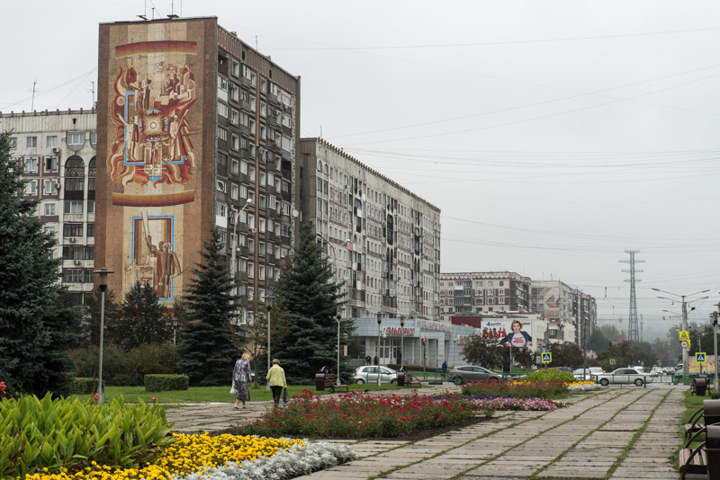
Novokuznetsk, Kemerovo Region, Russia
Founded in 1618 as a fortress on the right bank of the Tom River, Kuznetsk was a bulwark against invading tribes, notably the Dzungars of north-western China, but was of little importance until the development of the region’s coal reserves. In 1931 Kuznetsk was merged with a left-bank settlement to form Stalinsk, which was renamed Novokuznetsk in 1961. Having suffered during the times of the Soviet collapse, domestic coal mining became profitable once more after the 1998 devaluation of the Rouble, meaning that Novokuznetsk today is a modestly prosperous place. The city’s population remains lower now however than in Soviet times, and so there are few signs of modern development, leaving an urban landscape almost entirely built up during the heyday of the Soviet Union. Maciej and I spend a day walking around Novokuznetsk, taking in its numerous Soviet touches; Stalinist architecture of Theatre and Mayakovsky Squares, statues of Lenin and Gorky standing side by side, and broad avenues lined with elegant rows of poplars whose yellowing leaves signal the onset of autumn. The city’s central square is an ocean of concrete; a large flower-like monument commemorating the fiftieth anniversary of the USSR, a monolithic city administration building and nine-storied prefabricated apartment buildings, one with a fine Soviet mural. Across the Tom River is the restored nineteenth century Kuznetsk Fortress, bracing for an invasion from the south which never came.
Novokuznetsk makes a nice end point to our journey across European Russia and West Siberia. Ahead of us are the beautiful and fascinating republics along the Mongolian border, and the vast wilderness of Eastern Siberia and the Far East, as we continue our Trans-Eurasian journey to Magadan and the Pacific.
Stage 42 – Russia: The European Heartland [2/2]

Having passed through many church-dotted, historic cities of Russia on my way from the country’s southernmost border, I would now head into the northern wilderness in search of more natural attractions, finding these in the great pristine forests of the North Urals, the rugged, tundra-fringed shore of the Barents Sea and the beautiful Tersky Coastline of the Kola Peninsula. Finally, on Russia’s western border, I would complete my 2015 trip across Russia’s European Heartland.

Ilych River, Komi Republic, Russia
It’s the afternoon of the 11th June 2015 and with the truck in a secure car park, I say goodbye to my host Isa and get on an overnight train which takes me to Sosnogorsk, a small railway town next to the larger oil-city of Uktha, once the centre of one arm of Stalin’s GULag network. I am on my way to the far-flung town of Troitsko-Pechorsk on the Pechora River, where I will join a group of Russian tourists to visit the remote rock formations of Manpupuner, located in the wilderness of the North Urals, far beyond any road. In the waiting room of Sosnogorsk’s small railway station I meet Alexander, a corporate lawyer from Moscow, who is on the same tour and informs me that due to a last minute cancellation, it will be just the two of us (and guides) making the journey. We take the daily train south-eastwards, which crawls along the lumpy, single railway line reaching its terminus at Troitsko-Pechorsk just after midday. Here we are met by a driver in a minibus loaded with boxes of supplies and large plastic petrol cans, who takes us to a billiard-hall come restaurant where the local police immediately arrive to drag out an aggressive drunk. After lunch, we are driven fifty kilometres to a small clearing on the bank of the Pechora just opposite the village of Ust-Ilych, which marks the junction of the Ilych and Pechora Rivers.

Komi Woman, Yeremeyevo, Komi Republic, Russia
We are met by a man in a long wooden boat and after loading the fuel and supplies, we quickly get moving on the cold, calm waters of the Ilych, heading into the unspoiled wilderness of Europe’s eastern frontier. Alexander and I hunker down under tarpaulins to keep out the freezing cold air and admire the scenery. The river’s broad meanders are lined with a wall of pine trees broken only very occasionally by villages perched on the grassy riverbanks. It is in the third of these, Yeremeyevo, that we stop after eighty kilometres to sleep for the night in the house of our guide Zhenya. Yeremeyevo is a somewhat idyllic settlement consisting of neatly attractive wooden houses overlooking the wide, beautiful Ilych. Unlike most settlements of the Komi Republic the population here is entirely Komi, an indigenous Finno-Ugric nation of whom many, including our hosts, retain their indigenous Komi-Zyrian language; highly unusual in Russia where many Finno-Ugric nations are highly assimilated into Russian culture. Zhenya’s wife cooks an excellent dinner of grayling (which our hosts prefer to eat salted and raw, though I ask to be cooked) alongside excellent home-grown potatoes; perhaps the best-tasting freshwater fish I have ever eaten.
Yeremeyevo is the furthermost settlement on the Ilych and as we continue our journey up-river the following day, it narrows and enters denser forests, occasionally passing craggy cliffs of heavily uplifted rock strata as we enter the low, undulating, forested ridges of the Urals. We stop at three kordons; firstly at Izpryed where the two friendly rangers check our permits and allow us to continue into the Pechoro-Ilych Reserve, then at Shezhymdikost for lunch, and finally at the ranger station of Ust-Lyaga, 120 kilometres up-river from Yeremeyevo, where we will spend the night before continuing on foot tomorrow.

Ilych River, Ust-Lyaga, Komi Republic, Russia
In Ust-Lyaga we meet our second guide Sasha, who along with Zhenya prepares us another excellent dinner of freshly caught fish, whilst preferring to eat cheap kolbasa (luncheon sausage) themselves. Alexander and I make use of the camp’s banya and wrap up the evening alternating between sweating in the scalding steam room and plunging naked into the near-freezing water of the Ilych. Out of the noisy boat, I notice the great beauty of the river, which passes slowly in majestic silence, its surface disturbed only by the tiniest of eddies as it makes its way towards the Arctic under a sky of subtle blues, yellows and pinks which mark an extended twilight above the soft curves of low, pine-clad hills.
The following morning, after a very short boat journey to the mouth of the Ydzhydlyaga River we begin a twenty-kilometre walk through thick, dark, boggy, forest of lichen-covered birches and pines. I soon realise that I am rather under-equipped, having previously imagined a pleasant walk through dry pine forest. After a few kilometres the joy of being in untouched nature has long-since worn off and the boggy path, constantly made worse by tree roots, infinite hordes of biting mosquitoes, constant diversions around swampy sections and the pain in my left ankle which I twisted in the banya yesterday, has become a masochistic ordeal. At the very end of the day however, as I abruptly emerge from the dense forest onto a high bank of the Ydzhydlyaga, I have my first view of a treeless ridge of the Urals, on top of which are the seven natural stone towers known in the native Mansi language as Manpupuner (‘Mountain of Idols’). The view of the towers is utterly enthralling and enchanting, almost menacing in their verticality compared with the low, ancient ridge; the seven giants standing silently, eternally, far in the distance beyond yet more of this terrible forest. Somehow this glimpsed vision of the giants expresses to my mind perfectly the mystery of these dark, endless expanses of northern Russia where they lurk, magnificent and unseen. I can well appreciate how in the past the native Mansi tribes revered the idols fearfully and forbade themselves from climbing their ridge.
Pechoro-Ilych Reserve, Komi Republic, Russia
The fourth day starts calmly beside the Ydzhydlyaga, before we re-enter the wearying forest; though after some hours the very faint path starts to climb, finally leaving the swamps. Here I get a surge of motivation and pass Alexander and our guides, keen to reach the ridgeline before it clouds over. I climb briskly beyond the treeline at about 600 metres elevation, topping the ridge at around 750 metres, a few hundred metres distant from the giants. The view is simply astounding and all the miserable slogging through the forest is quite forgotten. Here is one of the most singularly striking natural wonders I have ever seen, with the seven stone towers of Manpupuner perched on the treeless alpine tundra of the ridge, overlooking a veritable ocean of forest stretching to the northern and western horizons, punctuated only very distantly by the bare ridges of the Urals and absolutely devoid of any trace of human presence. This thankfully protected forest is part of the largest swath of primeval forest remaining in Europe today. To the south and east are more bare ridges, demarcating the notional border between Europe and Asia.
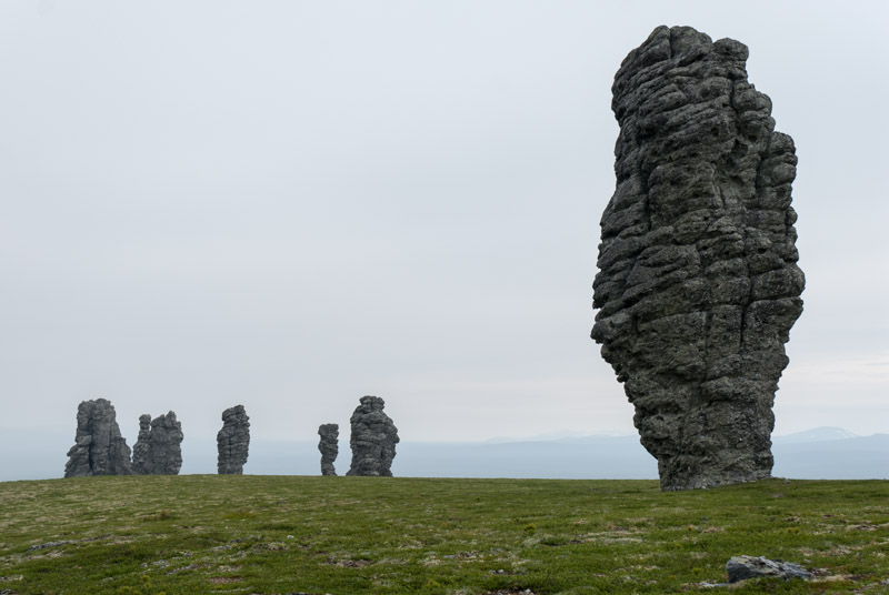
Manpupuner, Komi Republic, Russia
The rock formations themselves appear a dark, igneous grey but this is merely a thick covering of lichen covering the white, resistant schists from which they are made and which have weathered more slowly than the surrounding rock, leaving the seven towers between thirty and forty-two metres in height. I spend several hours around the rocks, enjoying them from all angles and looking out over the sea of forest. We rest at night in a recently constructed wooden hut (with the timber having been brought in by helicopter) and awake in the morning to low cloud and light rain, giving the giants a different, more brooding atmosphere without the expansive backdrop. Then begins the long return journey, retracing our route back for two days through the forest to the Ilych. Alexander and I often walk together and I feel that I get to know him quite deeply; a childhood marked by the relationship issues of his parents, an adolescent dream of visiting the US shattered upon finally visiting the country and finding a flimsy, commercialised reality. He also admits to being a womaniser, a pick-up artist and an assassin of aggressive feral dog packs in suburban Moscow. We return down-river, finally reaching Troitsko-Pechorsk and checking into a hotel, though I split with Alexander and take an overnight minibus back to Syktyvkar, saving more than a day compared to the sedate trundling of Russian Railways.

Decorated House, Emelyanovka, Arkhangelsk Region, Russia
I reach Syktyvkar at around 04:30, though the sun is already up, giving an odd feeling of walking in daylight through a dormant city. After having breakfast with Isa and thanking her profusely for her early-morning hospitality, I collect the truck and begin the road journey broadly north-westwards towards the Arctic. After the exertions of the last few days it’s a great pleasure to be driving the truck again and comfortably watching the world go past my window. After back-tracking on the main road towards Kirov for just over a hundred kilometres, I turn westwards and soon enter Arkhangelsk Region, where the scenery starts to change subtly from the dense, flat taiga (boreal forest) of Komi to a slightly more settled landscape of gently rolling hills. In the sprawling and rather ugly logging town of Kotlas, once also a major locus of Stalin’s GULag network, I join the Northern Dvina River whose wide, coffee-coloured waters I cross on a bridge just west of town. I follow the Northern Dvina downstream on a road which is partly paved and partly well-graded gravel, passing villages of traditional wooden houses; some extremely pretty and well kept and others derelict and collapsing. I camp for the night near a junction with the busy M8 Highway, which I drive the following morning to the delta of the Northern Dvina, which I cross once more on a long, pot-holed Soviet bridge to enter the city of Arkhangelsk, the chief port of medieval Russia.

White Sea, Severodvinsk, Arkhangelsk Region, Russia
I’m hosted in Arkhangelsk by Vladimir, who I join for a late breakfast. I immediately find Vladimir a very likeable, laid-back character and he soon calls his friend Alexander who drives us forty-five kilometres to the formerly closed city of Severodvinsk. Parking at a small patch of coastal forest, we walk onto a wide, sandy beach with picnicking families and a groups of youths drinking beer around a parked car blaring out tawdry music. The view is surprisingly beautiful; of a wide, clean beach shelving very gently out into the calm waters of the White Sea in which people are swimming and paddling dinghies. It’s hard to believe we’re little more than two hundred kilometres south of the Arctic Circle. Alexander takes us around Severodvinsk, stopping to peek across a small inlet to the nuclear submarine yard whose presence made the city firmly closed to all outsiders during the Soviet period, then into a pleasingly harmonious and uncrowded city centre of preserved Soviet architecture. I immediately warm to the atmosphere of Severodvinsk and we stay for dinner and beer, only returning to Arkhangelsk in the evening. Vladimir and I walk into the centre later in the evening, watching a beautiful pink sunset over the Northern Dvina at around 23:30, then heading into a bar for a few drinks and emerging at around 02:00 to a somewhat disorientating pinkish dawn light, with the sun rising just as we return to the apartment to sleep.

Wooden Apartment Building, Arkhangelsk, Arkhangelsk Region, Russia
Whilst this region has been settled since the earliest times of Russian history it was not until the mid-sixteenth century that the British, unsuccessfully searching for the North-east Passage to China, inadvertently opened a trade route to Russia via the Northern Dvina. In 1584 Ivan IV (Ivan the Terrible) founded New Kholmogory, which would later become Arkhangelsk, Russia’s principal sea port, though one that was made inaccessible by ice for several months of each year. When Peter the Great defeated the Swedes in the Baltic and established Saint Petersburg in 1703, he realised his dream of giving Russia a year-round, ice-free port and Arkhangelsk rapidly declined in importance. Today, Arkhangelsk is directly connected by rail and highway to Moscow and is no backwater, but my overwhelming impression after a day touring the city with Vladimir is of neglect and lassitude. There are numerous damp, warped and subsiding pastel coloured wooden apartment buildings, some in a shockingly advanced state of decay and creaking Soviet infrastructure of potholed roads and bowed tram tracks. It is nevertheless a very likeable place, and I’m slightly sad when my time with Vladimir in this shabby old port draws to an close.

Cathedral Square, Kargopol, Arkhangelsk Region, Russia
I leave Arkhangelsk and initially double back on the main highway towards Moscow, then join smaller, mostly unpaved roads which lead towards the Onega River. After several hours driving through the endless taiga, I reach the town of Plesetsk, connected to Russia’s Plesetsk Cosmodrome. Once an ICBM launch site, today Plesetsk is used for occasional high-latitude satellite launches and I know that a launch is imminent, but no firm date has been published. I later find a Soyuz launch took place the following day. The road eventually crosses the Onega near the village of Sholokhovskaya. It’s late in the evening, twilight is slowly descending and I stop at what is a blissfully tranquil spot; on the one side is the pretty village perched on the riverbank, with a skyline dotted by ancient, slightly dilapidated wooden steeples and domes, whilst on the other, a fisherman silently punts a canoe across the wide, millpond water of the Onega, whose surface is only very faintly disturbed by the very light drizzle.
I find myself in the town of Kargopol the following morning which surprises me with its abundance of ancient churches; rather like a northern Suzdal, though totally devoid of tourists. Today a charming backwater, Kargopol is an ancient place and must once have been one of the northernmost settlements of the Slavs. With the opening of Arkhangelsk’s maritime trade route in the sixteenth century, Kargopol prospered as a staging post on the road from Moscow. The city’s fortunes also waned in parallel with Arkhangelsk’s, though like many of Russia’s most faded cities, it was also bypassed by the railway. All this makes me fall for Kargopol; a quiet, untouched slice of ancient Russia, and I spend several hours strolling and admiring numerous fine sixteenth to eighteenth century churches which spread along quiet streets roughly alongside the overgrown, grassy bank of the Onega.

Chapel, Pyalma, Karelia Republic, Russia
At midday I begin a long drive, leaving Kargopol on an unsurfaced road heading westwards and entering the Republic of Karelia, the homeland of the Karelians who live on both sides of the Russia – Finland border. Karelia is subtly beautiful; a land of ancient forests and meadows dotted with small, wild lakes and neat villages. There is somehow something softer, more European about it than other parts of the north and I immediately warm to it. Like Arkhangelsk Region it is home to some fine pieces of wooden architecture and so despite the persistent rain, I stop in the village of Pyalma which sits almost on the shore of Lake Onega and has a quaintly miniature wooden chapel in a small graveyard. Late in the afternoon I join the main M10 Highway connecting Saint Petersburg with Murmansk on the Arctic Coast and drive steadily north as far as the Kem River, where I camp on the shores of a reservoir, watching an otter swimming on its back and later hearing an owl hoot in the trees directly above me.
I start early the next morning, driving the short distance through the town of Kem to the small port of Rabocheostrovsk where I park the truck and board a ferry out into the White Sea to the infamous Solovetsky Islands. It’s a perfectly clear, cloudless morning and the White Sea is an endless shimmering plain of liquid light. The ferry heads out into a seascape where deep blue sky meets deep blue sea and soon the low, sculpted form of the Solovetsky Archipelago appear in the distance.

Solovetsky Monastery, Solovetsky Island, Arkhangelsk Region, Russia
The Solovetsky Islands have been centre of monasticism since the fifteenth century and the main island, where the ferry docks, is dominated by the massive, almost Cyclopean walls of Solovetsky Monastery. Now both an active monastery and a tourist attraction, this fortress on the White Sea has withstood the sieges, uprisings and invasions of the last few centuries of Russian history, but it is also an important landmark in perhaps the darkest period of Russian history. Under the Soviets, Solovetsky Monastery was liquidated in 1920 and the islands became a prison camp; the archetype of Stalin’s GULag which would enslave and murder many millions of Soviet citizens. After exploring the monastery and its surroundings, I walk along the beach and find a quiet spot, looking out to a greying sea. I’m no fan of the crowds of tourists and with only a day on the island and no means of transport other than walking, I lack the time required to fully explore the islands and once more feel slightly frustrated at the pace of the trip.
Back on the mainland, I spend the evening and much of the next day driving steadily north, first through Karelia, through a largely unpopulated wilderness of forests and small lakes. I stop at a roadside monument which marks the Arctic Circle at 65.56º North before driving on into Arctic territory for the first time in my life. Soon after, I enter Murmansk Region and cross a final inlet of the White Sea, pushing ever further north onto the root of the vast Kola Peninsula. Around the copper and mining city of Monchegorsk the Arctic wilderness is rudely interrupted by a localised ecological disaster zone of dead forest, but soon after the scars of the landscape heal and I’m back driving around pristine-looking lakes backed by low mountains still lightly flecked with last winter’s snow.
Sailors, Murmansk, Murmansk Region, Russia
By mid afternoon I reach the regional capital, Murmansk, which with a population of around 300,000 is by far the largest city in the world above the Arctic Circle. Murmansk was also the last city founded in the Russia Empire, just two years before the October Revolution and was an important port during twentieth century conflicts, despite being set on an inlet relatively far from the ocean. I walk across the city and climb a small hill where the thirty-six metre high Alyosha Monument, a Soviet solider in a greatcoat with a rifle slung over his soldier overlooks Kola Bay; a piece of 1970s Soviet monumental concrete outdone in size only by ‘The Motherland Calls’ in Volgograd. I’m hosted in Murmansk for one sunlit night by Igor and Marina, a middle-aged couple who live in an apartment with their very excitable Dalmatian Bert. Above their kind hospitality I’m inspired by the couple who, despite being in their fifties, make road trips into neighbouring Finland (where they claim mosquito numbers are far more manageable) on a tandem bicycle, towing Bert along in a trailer.
I make another walking trip into Murmansk the following morning, this time to the city’s elegant twentieth century centre which I immediately like. Murmansk is a city which seems to me remarkable only for how ordinary it looks, with little to distinguish it from other Russia cities. Murmansk was the type of far-flung outpost which the USSR could support, but in today’s post Cold-War, market-driven economy, despite remaining an important centre for the Russian Navy and Air Force, it is a city in decline. Thankfully, this does not translate to obvious decay and dereliction, but instead means that Murmansk’s centre is unspoiled by ugly modern development, retaining a harmonious centre of grandiose civic architecture from the heyday of the Soviet Union. In fact, the damp, patinaed pastels of Murmansk are perhaps the best-preserved example of a Soviet city I can remember seeing since Minsk.

Barents Sea, Teriberka, Murmansk Region, Russia
Wanting to see the Arctic coastline, I set off eastwards onto the Kola Peninsula in the afternoon, finally leaving the forests and entering the tundra; an undulating landscape of thick, spongy herbs which smell almost like the wormwood-steppes of Central Asia but which are full of bloodthirsty mosquitoes that emerge in clouds with each step I make onto the spongy flora underfoot. Turning north, I reach the coastline in the half-abandoned looking fishing town of Teriberka, beyond which I find a rough track down to the coast where I camp for another ‘night’. This is far from being the northernmost point of mainland Europe, but unlike Norway’s Nordkapp, the coast here is truly the edge of the Eurasian landmass, for there is nothing north of here but unbroken sea for 2,320 kilometres to the North Pole. In fact, walking down to the coast of the thrashing, steely-blue waters of the Barents Sea and looking out beyond the rose-pink headlands which bound Teriberka Bay, I can’t help but think of the Ancients whose world was flat and bounded by the huge, mythical River Ocean.

Pomor Woman, Varzuga, Murmansk Region, Russia
Teriberka marks the northernmost extent of the trip, and from here I will do some lengthy backtracking, starting with the road to Murmansk and then the highway back towards Karelia. I make a side trip through Apatity to Kirovsk on the edge of the Khibiny Mountains, but they are obscured with low cloud, making me return to the highway and turn east in Kandalaksha on the southern edge of the peninsula, which is known as the Tersky Coast. This coastline remains home to descendants of early Russian settlers known as Pomors who moved from The Novgorod Republic to the shores of the White Sea as early as the twelfth century, long before the rise of Moscow, and were generally engaged in fishing and other local enterprises rather than falling under the ownership of feudal landlords. I spend a whole day driving slowly along the Tersky Coast starting in thick forests around Umba, then descending to the beautiful shoreline and stopping in the village of Varzuga, located around twenty kilometres inland. Famed for its salmon-rich river, Varzuga dates from the late fifteenth century, making it perhaps the oldest settlement on the peninsula. It also feels wonderfully isolated, with just a few hundred inhabitants living in attractive wooden houses surrounding the fine, all-wooden Church of St Afanasy, which dates from the nineteenth century but was originally constructed by monks from the Solovetsky Islands in the fifteenth century.

Kuzomen, Murmansk Region, Russia
Near Varzuga a four-wheel-drive track leads into the forest, becoming deep sand and emerging at the even smaller village of Kuzomen. Despite being located very nearly on the Arctic Circle, Kuzomen has the feel of a remote desert settlement with a main street of soft sand and wooden walkways for pedestrians. Neat wooden houses sit behind picket fences and horses roam the streets; perhaps more practical than wheeled vehicles for getting around. The village sits on an eight-kilometre bar of sand brought from the hinterland by the Varzuga River, which meets the White Sea here. The river is un-bridged and thus Kuzomen marks the end of the road; beyond is just roadless wilderness, curving around the coast of the peninsula all the way back to Teriberka. The scenery is magnificent and after driving a short distance in the sand I decide to camp for the night on the beach, just above the high water mark, watching an endlessly changing sky of subtly textured clouds as a sea squall makes its way ashore.
Kandalaksha Bay, Murmansk Region, Russia
Returning along the coast I stop at a point on the beach where the pink volcanic bedrock has a seam of rich purple amethyst, a hint of the mineral riches found in Kola’s volcanic rock. Later I stop at some rocky coastal hills near Kandalaksha, from where the view across Kandalaksha Bay is unexpectedly mesmerising; a wide tapering bay of blue water between the rugged coasts of the peninsula and mainland, dotted with pristine forested islands, one of the most beautiful spots I can remember seeing in Europe. I take a very steep, rough track down to the bay to reach an intriguing Neolithic labyrinth whose function remains only speculative, but of which examples may be found at numerous sites around the White Sea. It’s another magnificent spot and so I decide to stay for the night, looking out towards the low, rolling hills of the mainland which are illuminated by the low rays of the night sun, their tops treeless and white with tundra. As midnight approaches the shadows creep slowly up the hillsides across the tranquil mirror of the White Sea, which reflects lances of cloud in a yellowing sky; a perfect final wild campsite in Russia.
Petroglyph of Whale Hunt, Zalavruga, Karelia Republic, Russia
It’s a seven-hundred kilometre drive south from Kandalaksha to Petrozavodsk, but I break the monotonous journey in the town of Belomorsk, another White Sea port from where one may reach the Solovetsky Islands. Nearby in a rocky forest clearing accessible only by foot is the Neolithic petroglyph site known as Zalavruga, where the pinkish gneisses are covered by expressive ancient rock art. The style is consistent with that found across Eurasia, but here there are also rich scenes of hunting moose and whales; perhaps my favourite is of twelve men paddling in a boat, poised with bent knees, pursuing a harpooned white whale; a fascinating insight into Neolithic culture. I reach Petrozavodsk, the Karelian capital in the evening where I am hosted by Anton, who lives with his girlfriend and two sons. Anton is an architect and a talented photographer and explains to me that he has ‘some problems with his passport’ and therefore only travels in Russia; something he has done quite thoroughly to destinations as far flung as Wrangel Island, where the very last mammoths would have roamed at roughly the same time that the petroglyphs at Zalavruga were being carved.
Kizhi Pogost, Kizhi, Karelia Republic, Russia
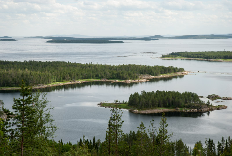
Petrozavodsk sits on the shores of Lake Onega, the second largest in Europe and I make a tourist trip the next day on a green Soviet Kometa hydrofoil to the museum island of Kizhi. There were once several villages located on the small island, notable for their beautiful wooden churches. Today the entire island is a museum, centred around the two highly distinctive eighteenth century wooden churches (one with twenty-two domes and the other with nine) which together are known as Kizhi Pogost. Elsewhere around the island are a number of other churches transplanted from across Karelia, as well as several large Karelian wooden farmhouses showing how peasant families lived here; in surprisingly good conditions if the preserved and period-decorated rooms are to be believed. It’s hardly an adventurous destination but the walk is very pleasant and free from mosquitoes for once and with beautiful views of a gathering storm out across the beautiful blue waters of the lake.
Back in the capital I spend another day strolling and find Petrozavodsk to be a very pleasant, if not particularly interesting city. Like much of Karelia it feels slightly more westernised than much of Russia with some nice real-estate; tree-lined streets of good-looking apartment buildings, though very little pre-dates the Second World War. It feels like a particularly liveable city and I decide that it would most likely be my pick of Russia’s European cities in which to live.

Mosaic of Varangians, Staraya Ladoga, Leningrad Region, Russia
After two relaxing days in Petrozavodsk, I start the final trip south, leaving the forested northern wilderness and driving just south of Lake Ladoga towards Saint Petersburg. I make one last stop in the town of Staraya Ladoga a few kilometres off the main road. Occupying a grassy bank of the Volkhov River, Staraya Ladoga was one of Russia’s oldest cities, located on a trade route between Scandinavia and the Middle East and according to legend was founded by Rurik, the first Varangian (Viking) leader of ancient Rus’. Today there is a rather obviously restored kreml (fortress), two old churches and even an ancient burial tumulus attributed to Oleg of Novgorod, a close relative of Rurik, but somehow the place has the air of histrionics about it and lacks in authenticity, with a colourful recent mosaic of the legendary Varangians leaving the most lasting impression upon me.
I turn south well before Saint Petersburg but get caught up in the furious Friday afternoon traffic heading out of the city; a miserable spectacle of reckless speeding through small towns and villages which I find wearying. Just after midnight I pass through Pskov, thus for a second time passing one of European Russia’s nicest cities unfortunately without stopping. In the early hours of the morning I slip out of Russia, thus ending my 2015 journey.
I greatly appreciate the luxury of being able to take eight weeks of holiday from my job, but at the same time I realise that the trip, with its defined time constraints, has been fundamentally different from my previous, long-term travels. Nevertheless, making this trip to the edges of European Russia has shown me yet more sides to this ever-fascinating country, but I am also conscious that winter, with frozen swamps and not a single mosquito, is the time to really explore the Russian North. And such are the beginnings in my mind of a very ambitious trip to cross Russia to the Pacific Ocean in Magadan and then return in winter; a trip for which I will need a different vehicle and a lot of research and preparation.
I stop the next day with my old friend Maciej in Gdansk, then after a swelteringly hot rest day drinking beer and catching up in his apartment, make the final drive across Germany and back to base on the 7th July 2015, where I must slip back into my odd corporate double-life and begin planning and preparation for the next Russian adventure.
Stage 42 – Russia: The European Heartland [1/2]
Russia has fascinated me since I made my very first visit to the country in June 2007, at the very start of this Odyssey. Its huge territory presents almost limitless opportunities for exploration in wild, pristine and sparsely populated environments which stretch from the borders of the EU to the Pacific Ocean. The Russian people are also a great draw for me; free-spirited, highly cultured and intrinsically welcoming, a pleasant juxtaposition of European and Asian qualities and a fascinating mix of races from across Eurasia. Russia is a country which offers a scale of travel and a depth of immersion which in my experience is unmatched. Having made more than ten individual trips to Russia, mostly in 2010-11, I had plenty of experience of the country, yet I craved for more; specifically to make journeys to the far north and later far east (and back); journeys which would occupy the next four years of my free time.
The first of these would be the main focus of my 2015 journey. After entering the far south of Russia from Azerbaijan, this stage would take me right across European Russia to its eastern boundary in the vast wilderness of the North Urals, then north to the shores of the Arctic Ocean. Between these natural boundaries I would stop in some of Russia’s most ancient cities, before turning my attention to the beautiful landscapes and twenty-four-hour daylight of the country’s far north and completing a completing a ten thousand kilometre journey across Russia’s European heartland on the Estonian border.

Caspian Sea, Makhachkala, Dagestan Republic, Russia
On the 25th May 2015 I cross the Samur River and after a friendly but rather lengthy process at customs, I start my trip across Russia in the Republic of Dagestan, one of my very favourite parts of the country. I pass the glorious Sassanian-Persian Naryn Kala Fortress above Derbent and arrive in the capital Makhachkala in the early evening, to a warm welcome from my old friend Bagdat, with whom I had stayed on my first visit to the region in 2010. The transmission of the truck has been making ominous noises ever since entering Turkey and so I decide to take it to a mechanic, where it is diagnosed with a worn clutch disc. Though the underlying reason seems to be general wear in the transmission, something which cannot be quickly rectified here, a new clutch disc will make a temporary cure. With the help of Zaur, whom I befriend at an auto parts store, a new clutch is quickly flown down from Moscow, being carried for a small fee by a passenger using an efficient system which is typical of the pragmatic approach Russians take to solving problems, a breath of fresh air coming from over-regulated Western Europe.

Craftsman, Makhachkala, Dagestan Republic, Russia
Whilst waiting for the clutch disc to arrive, I spend a few days in Makhachkala, which is an interesting blend of ancient Asian tradition and modern Russia; where I can sit with Bagdat’s cousin and two of his friends knocking back vodka while veiled women pass in the street outside. Makhachkala, and Dagestan as a whole, has become much safer since my last visit (when I witnessed a long gun battle in the streets) thanks to the ‘liquidation’ of many militants in security operations before the 2014 Winter Olympics in nearby Sochi, and a general exodus of others to join the fighting in Syria and Iraq. I hang out at the National Museum, where Bagdat works, and once again enjoy the company of his colleagues; wisened older men who lived their lives in the Soviet Union and wear their different national identities distinctly but lightly; another feature of Dagestan which I find rather endearing. There’s Magomed, a chain-smoking engineer, one of the museum’s craftsmen, with his love of the Beatles and all things German, and Temur, who with obvious tragedy and a touch of apprehension from his colleagues tells me that his two sons disappeared three years ago after quitting their jobs and getting involved ‘in something’. Both seem finely tuned to the museum’s old workshops and their rather frustrated intellect and camaraderie reminds me strongly of the descriptions of the Moscow sharashka in Solzhenitsyn’s First Circle.

Landscape, near Budyonnovsk, Stavropol Territory, Russia
Soon enough it’s time for me to move on; to say farewell to the gentlemen in the museum, thank Zaur for his help in finding a new clutch disc so quickly, to thank Bagdat and his mother for their generous hospitality, and begin a long journey northwards. I drive roughly parallel to the coast, initially re-tracing the route I took in 2010, but just past the brandy producing town of Kizlyar I turn westwards onto a quiet provincial road across the flat pre-Caspian steppe, passing through the outpost town of Yuzhno-Sukhokumsk and then crossing into Stavropol Territory where the land abruptly improves and I find myself passing small but prosperous looking farming communities; I am back in Russia proper. Just beyond the town of Neftekumsk I stop for the night, but my hopes of spending a cool night on the back of the truck sleeping under a star-filled sky are dashed by the numerous mosquitoes which buzz all around me as soon as I step out of the car; an annoyance which will become ever worse as I move northwards.

Lock No. 14, Volga-Don Canal, Volgodonsk, Rostov Region, Russia
In the town of Budyonnovsk I turn northwards once more through huge fields on a road lined by flowering trees and I’m impressed by the scale of agriculture which seems to be thriving here in Russia’s southern steppes. As I reach the Kalmykia Republic the quality of the land deteriorates once more and I’m again struck by the heavy set faces of the Kalmyks, an unexpected sight in what still seems like provincial Europe. In the afternoon I stop in Volgodonsk, a pleasant-looking small town located well away from any major highway and where little appears to have changed since Soviet times. The city is located on the southern edge of the Tsimlyansk Reservoir on the Don River, at the northern end of which starts the Volga-Don Canal which links the two great rivers of European Russia and thus the Caspian and Black Seas and also gives Volgodonsk its name. In a territory as large as Russia, rivers have always been a key means both for control and communications, and for trade, and it was along the rivers that the early Varangian (Viking) controlled state of Rus’ was established in the ninth century, operating the Volga Trade Route which connected northern Europe to the Caucasus and even Abbasid Baghdad.

Eternal Flame Monument, Tambov, Tambov Region, Russia
On my way out of town, I stop at the Don River and watch a ship passing through an ornate, Stalinist-era lock, part of the Volga-Don Canal system, before continuing my northward journey on a small back-road eventually joining the M21, which I take briefly before turning north once more in Surovikino and soon stopping to camp, again having to take refuge in the car from the voracious mosquitoes. The following day, I re-cross the Don in Serafimovich and notice an immediate change in the landscape; from the endless rolling farmland of southern Russia, dotted only occasionally by small villages beyond the fields, to a more varied landscape with small stands of pine forest, sandier soil and linear villages of pretty wooden houses lining the road.
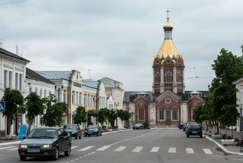
Despite this change, I am still in an area outside of the ancient heartland of Russia, an area which even after the withdrawal of the Golden Horde in the fifteenth century, was a frontier region used by raiding groups of Crimean Tatars and Nogays who would prey on the southern flanks of the country. After joining the busy M6, I stop in the afternoon in Tambov, a city established in the seventeenth century as border fortress against Tatar raids, later to become a provincial trade centre. I’m hosted in Tambov by Olga, a photographer who lives with her brother, and who takes me out in her car for a tour of the city. Tambov is a pleasant place, far enough from Moscow to retain a pleasant provincial atmosphere, but with sufficient infrastructure to avoid being a neglected backwater. We drive around taking in the city’s modest sights until we reach the central square with its Eternal Flame Monument to those killed in the Great Patriotic War, when a roiling mass of black cloud suddenly breaks into a heavy summer storm.
Ascension Cathedral, Kasimov, Ryazan Region, Russia
Tambov is around 450 kilometres south-east of Moscow, a city which emerged from the chaos of the thirteenth century Mongol invasion to later become the centre of a new Russian state, and remains by far the most important city in modern Russia. I however head northwards on small roads towards some of Russia’s oldest cities, glad to avoid Moscow’s wearying sprawl and traffic by doing so. I pass through faded small towns and depopulated villages, often with old churches still in ruin after the neglect of the Soviet period, their whitewash and plaster slowly peeling away to leave a damp brick shell. I cross the wide, slow Oka River and stumble by accident into the beautiful small town of Kasimov, with a charming unmodernised centre whose main street runs straight to the large nineteenth century Assumption Cathedral. Later in the afternoon I stop in Murom, one of the very oldest cities of Russia, first listed in the Primary Chronicles, the earliest history of the Eastern Slavs, in 862 CE.
Murom harks back to the times of Kievan Rus’, when it is believed that Varangians (Vikings) from what is now Sweden came to rule over the Slavs and Finno-Ugric peoples of northern-western Russia, soon integrating and spreading southwards to Kiev. There they would establish Kievan Rus’, the first Eastern Slavic state, a loose federation of principalities such as Murom, which would last until the Mongol invasion. Culturally, Kievan Rus’ is the ancestor of Ukraine, Russia and Belarus however, the origins of the modern Russian state are very much Moscow-centric with only distant connections to pre-Mongol Kievan Rus’. Murom is interesting for having been on the eastern-most frontier of Kievan Rus’, a border with the uncharted territory of the native Finno-Ugric tribes, locally the Muromians. Today Murom is a pleasant enough provincial town, though following heavy destruction in Soviet times, there is scant evidence of its historical importance and I’m soon driving out of town to spend another night camping in the truck to avoid the voracious mosquitoes.

Church Of The Intercession On The Nerl, Bogolyubovo, Vladimir Region, Russia
In the morning I pass through the regional capital of Vladimir, which I regard as one of Russia’s most beautiful cities, but stop only in the adjacent village of Bogolyubovo. Here, well beyond the heavy traffic of one of the country’s main highways, alone in the swampy fields along the Nerl River is the twelfth century Church of the Intercession on the Nerl. Elegantly slender, with the beautiful proportions of an early, strongly Byzantine-influenced cross church, but crowned with the later addition of a traditionally Russian onion dome, the Church of the Intercession ranks immediately alongside the similar Cathedral of Saint Demetrius in Vladimir, which I visited on a snowy December morning four and a half years ago, as one of my favourite pieces of Russian architecture. The immediate surroundings of the church, a wild, unkempt grassy landscape of ox-bow lakes and willow trees makes for what to me is an almost perfectly Russian scene.
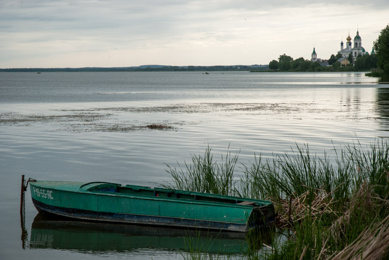
Lake Nero, Rostov, Yaroslavl Region, Russia
I’ve entered the region known historically as Zalesye, which came to prominence in the twelfth century following the decentralisation and decline of Kievan Rus’. The name ‘Zalesye’ literally means ‘beyond the forest’, referring to the swathe of forest which separated it from the other successor states such as the Republic of Novgorod to the north-west, or those further south around the Don. Once the Principality of Vladimir-Suzdal, today it’s a beguiling region with small farming villages built around ancient whitewashed churches. Amongst the rolling fields are towns such as Yuryev-Polsky; clearly once of some importance but now a real backwater and those which have managed to fare a little better into modernity, such as Pereslavl-Zalessky, where I make my next stop. Located on another major highway, Pereslavl-Zalessky is busy with Muscovite tourists who come to enjoy the town’s historic atmosphere and location on the shores of Lake Pleshcheyevo. It was here that one of Russia’s greatest heroes was born in 1221; Alexander Nevsky, who would lead the country through wars with western invaders and eventually submit to the Mongols of the Golden Horde, preserving medieval Russia; something for which he was canonised in the sixteenth century by the Russian Orthodox Church. Nevsky’s youngest son Daniel would go on to found the Grand Duchy of Moscow in the late thirteenth century; transforming it into the city which would forever eclipse these more ancient cities of the early principalities of Rus’.

Rostov, Yaroslavl Region, Russia
Not far north from Pereslavl-Zalessky is the very ancient city of Rostov which, like Murom is among the oldest in the Russian heartland, having first been mentioned in 862 CE, but which is much more attractive and is perhaps my favourite in the region. I stop outside the large brick kremlin (fortress) and walk to the shore of Lake Nero, where I’m greeted by a vista of exquisite beauty in this seemingly endless landscape of grass, lakes and hills. It’s a scene which so perfectly encapsulates rural European Russia; understated, timeless, unspectacular though soul-stirringly beautiful; a live view of a Russian watercolour looking across the limpid waters of the lake towards the silhouetted domes of the Monastery of Saint Jacob and the low, rolling folds of Russia beyond. Rostov’s seventeenth century Kremlin is exotically beautiful, almost kitsch in its fairytale proportions; a picture-book image of onion domes and (largely decorative) defensive towers which stand over the the city’s quiet streets and still-active trading arches, all giving Rostov a very pleasant small-town atmosphere.
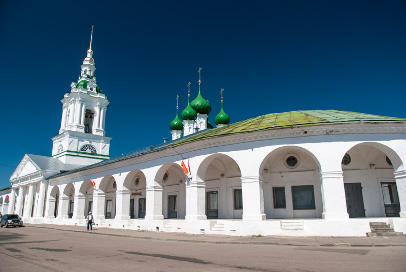
Trading Arches, Kostroma, Kostroma Region, Russia
I stop for the evening in Ivanovo which, unlike its neighbours, is a city lacking any historical allure; a city of textile factories fallen on hard times and capital of a region which is very nearly the poorest in the entire country. The following day I drive north and in the picturesque town of Plyos, famous as the retreat of Russian landscape painter Isaac Levitan, I meet the greatest river of the Russian heartland; the Volga. Together with the Don and Dnieper, these three rivers are of great importance in Russian history; firstly as the very conduit along which the nation was established and later as a means to connect and control a large, sparsely populated territory. I drive up the Volga, stopping next in the city of Kostroma, which sits on the mighty river’s left bank. On the edge of town, sitting beyond the wide junction of the Kostroma River with the Volga lies the fourteenth century Ipatievsky Monastery, an important landmark in Russian history. It was here, in 1613, during an interregnum of foreign domination and famine known as the ‘Time of Troubles’ following the demise of the Rurikid Dynasty (descendants from the original Varangian rulers of Rus’) that the first Romanov King, Mikhail was crowned, seeding the royal line which would transform Russia into an empire and rule the country until the Bolshevik Revolution of 1917.

Volga River, Kostroma, Kostroma Region, Russia
Kostroma has a delightful, preserved eighteenth and nineteenth century city centre radiating out on spokes from the central Susanin Square, named for a semi-legendary martyr who is said to have refused to reveal the hiding place of Tsar Mikhail to the Polish-Lithuanian occupiers of Russia at the time and was tortured to death in punishment. Amongst the grandiose, pastel-coloured administrative buildings are a distinctive fire-watch tower and a very nicely preserved, though rather quiet, example of city trading arches; a typically Russian marketplace which has often disappeared in Russian cities. I spend the day strolling around Kostroma; visiting an art museum, then walking down through a shady park to the river. It’s a perfect early summer day and whilst a few weeks ago the last dirty remains of the winter snow would have been lying around, now the city is at its most beautiful with all plants in bloom and people out in the streets. The temperature is in the mid-twenties and the sky is a cloudless deep-blue for the whole day; the start of the long, wonderful Russian summer. Down on the Volga, locals are enjoying the weather on a sandy riverbank, an excellent inland beach, where one can lie in the sand as the Volga slowly moves past on its way to the Caspian and feel quite detached from the stream of traffic crossing the city’s road bridge from the south. By late afternoon I am slightly regretting having to leave, feeling that Kostroma is one of Russia’s nicest cities.

Church Of The Prophet Elijah, Yaroslavl, Yaroslavl Region, Russia
It’s not far from Kostroma to Yaroslavl, my next stop on the Volga. Founded as part of Vladimir-Suzdal, then becoming capital of its own principality, before being merged into the Grand Duchy of Moscow in the fifteenth century, Yaroslavl is the largest of the ancient cities lying to the north-east of Moscow, in an area (incorporating Zalesye) known as the Golden Ring. I’m hosted in the city by Roman, a local small businessman who works from home and who shows me the UNESCO World Heritage-listed centre of the city after dark. Yaroslavl has a centre filled with parks and churches but, perhaps due to its greater size, does not quite have the harmonious feel of Kostroma. I spend all of the following day strolling in Yaroslavl, visiting a wealth of churches, most spectacularly the Church Of Saint Elijah The Prophet, which sits in a large square and has a distinctive tent-style steeple and wonderful frescoes. What I most enjoy finding in Yaroslavl however is something in my experience very unusual in Russia. On the Volga Embankment is a tranquil, tree-lined street of tall beech trees and quality housing; not choked with traffic or filled with the vulgar black SUVs of local ‘biznesmen’ who ruin the area with crass cafes and boutique shops. Here instead is a slice of European sensibility; a genuinely pleasant, liveable centre to the city, with the cupolas of various churches visible in the gaps between elegant apartment buildings.
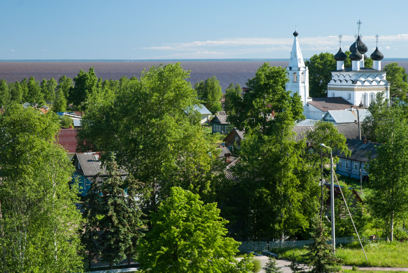
Belozersk, Vologda Region, Russia
From Yaroslavl I continue up the Volga as far as the pretty city of Rybinsk, where I drive across the Volga on an attractive iron bridge and turn north. Here, driving along the bank of a large reservoir on the Volga, the landscape changes noticeably; gone are the fields and ancient cities of the Golden Ring region, replaced by dense forest, lakes and villages of wooden houses; I am beginning to enter the wilds of the Russian North. It’s a very tranquil and pleasant drive, though in the afternoon I find myself passing through the noxious city of Cherepovets where the air is so polluted with industrial fumes that I have to wind up my windows whilst stuck in traffic. It’s not long however before I’m back on a minor road, heading north through more forests and swamps and occasional fields, towards the ancient city of Belozersk which I explore in the morning after a night camping. Belozersk is, along with Murom and Rostov, one of the oldest cities in the Russian heartland, having also first been mentioned in 862 CE, but feels far removed from its contemporaries. Now effectively a large village with a feeling of being rather distant from central Russia and with a slight air of timelessness, I immediately like the place. Especially fine is the view from an ancient settlement mound across the rooftops of Belozersk towards the misleadingly named ‘White Lake’ whose waters are a tannin-rich, dark, reddish-brown; a sure sign of having entered the North.
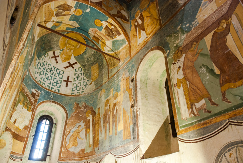
Frescoes, Ferapontov Monastery, Ferapontovo, Vologda Region, Russia
After a walk along the lake-shore, whose sandy beach is scattered with driftwood, watching distant ships crossing the lake, which is part of the Volga-Baltic waterway, I head east on an unsurfaced road, taking a free ferry across a narrow reservoir to the town of Kirillov. Soon after coming under the control of the Grand Duchy of Moscow in the end of the fourteenth century, these remote northern territories of the Russian heartland became a refuge for monasticism, and their remoteness has seen them escape many of the ravages of Russian history. The first of two monasteries is the Kirillo-Belozersky Monastery in Kirillov itself, picturesquely set on the banks of Lake Siverskoye and notable for its huge defensive walls with distinctive towers. A few kilometres away in the village of Ferapontovo is the second, Ferapontov Monastery which is less architecturally vibrant than Kirillov, but contains a collection of magnificent frescoes. Painted by the Russian master Dionisius in 1495-96 and quite staggeringly complete and unmolested, the frescoes cover every wall and roof in the interior of the Cathedral of the Nativity, making it the last medieval church in Russia with intact frescoes.

Vologda River, Vologda, Vologda Region, Russia
In the late afternoon I drive to the regional capital of Vologda, where I am hosted by Sveta, who lives alone and works as a theatre set designer. Vologda became rich during the sixteenth century, based on passing trade between Moscow and the port of Arkhangelsk on the White Sea, which for a long time was Russia’s main sea port. With the establishment of Saint Petersburg on the Baltic coast in the eighteenth century, much of this trade was diverted and Vologda declined. With improvement in infrastructure however, the city’s fortunes later recovered somewhat and around the central Cathedral Square Sveta shows me several fine examples of coloured wooden merchants’ houses with finely carved decorative window frames known as nalichniki. Immediately after the Bolshevik Revolution, Vologda was Russia’s diplomatic capital, away from the ravages of the First World War, and it is perhaps for this reason that the city received one of the very first statues of Lenin, in 1925, which still stands. Unlike any other of the many Lenin statues I have seen, here Lenin is life-sized, showing just how small he was.
From Vologda it’s a long drive east towards the Urals, passing a swathe of very sparsely populated territory, rather forlorn-looking villages and towns dependent on the timber industry, using a road which in places is newly built and at one point swarmed by hornets, making me keep the windows shut and suffer the summer heat. It’s well after dark when I reach my next destination; the city of Kirov, where I am hosted by Zhenya, who calls himself Jack in English. Jack is one of a community of low-budget Russian travellers who return to Russia only for long enough to scrape together a little money doing informal work, before taking the road once more on long journeys hitch-hiking, camping, Couchsurfing and trying to make a little money in order to extend their travels for as long as possible.

Kirov Monument, Kirov, Kirov Region, Russia
Kirov feels again different from any of the cities I have recently visited; a large, mostly unattractive industrial city which feels a long way from anywhere else and was indeed historically a place of exile. Known formerly as Khlynov, then Vyatka, the city was renamed in honour of Bolshevik leader Sergey Kirov, who was born in the town of Urzhum south of Vyatka and murdered (in Leningrad) in 1934. Kirov was the human face of Bolshevism; a charming, handsome man amongst ruthless (often criminal) contemporaries. Whilst there is no concrete evidence, it is likely that Kirov was murdered by the most ruthless of the Bolsheviks, Stalin, who saw Kirov’s popularity as a threat. Allegedly a close friend, Stalin publicly mourned Kirov’s tragic death with great fanfare and used the event to set off his Great Purge of the Bolshevik Party, staging show trials which swept up hundreds of thousands of Soviet Citizens on flimsy or absurd charges, to be incarcerated or summarily executed. Poor Kirov still stands beaming benignly on his plaque; a monument to one of the darkest periods in Russian history, a tragedy which sits rather awkwardly in modern Russia, with many deliberately trying to forget or wilfully deny the dark events of Stalin’s rule, while the tyrant is slowly being rehabilitated by the current regime.
From Kirov it’s another long drive, this time north into the forested wilderness of the Komi Republic where I stop in the low-rise capital Syktyvkar. I’m hosted in Syktyvkar by Isa, who is delighted to have a guest in such a far-flung spot and introduces me to a number of her friends. My reason for stopping in the city is however to put the truck in a secure car park and prepare myself for a journey to the remote primeval forests of the North Urals.
My journey to this outpost in the taiga has taken me across much of European Russia, across the most ancient heartland of the country, through some of the country’s most pleasant cities. From here however the nature of my journey will change slightly, as I start to explore the great northern wilderness, up to the Arctic Circle and Barents Sea.
