
Stage 43 – Russia & Kazakhstan: Trans-Eurasia [2/3]

Having crossed European Russia and West Siberia, Maciej and I would now embark on the next stage of our route to Magadan; through the mountains, rolling steppe and vast taiga (boreal forest) of southern and eastern Siberia, driving where possible on quiet back-roads and passing through a magnificent and varied landscape as the warmth of summer gave way to the vivid colours and deep blue skies of autumn. Leaving the main Trans-Siberian transport routes, we would come into contact with the indigenous cultures of Siberia; from the intriguing remains of ancient pastoralists to the nomadic Khakass, Tuvans and Buryats, whose cultures are recovering from Soviet repression, and who make up part of the great diversity of Russia’s population. This would be the most the scenic and exotic leg of our Trans-Eurasian journey.

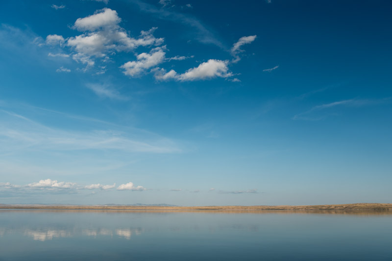
Abakan Range, near Orton, Kemerovo Region, Russia
On the rainy morning of the 2nd September 2017, Maciej and I leave Novokuznetsk, driving east alongside the Tom River on roads blackened with coal dust, to the coal mining town of Mezhdurechensk where the road ends. From here a railway continues eastwards over the mountains of the Abakan Range towards Askiz in the Republic of Khakassia, a journey of 220 kilometres by rail, but well over a thousand kilometres by road, via a circuitous route backtracking far to the north to avoid the mountains entirely. However, from carefully studying satellite maps and high-scale Russian paper maps, I have identified what seems to be a viable track across the mountains via the village of Orton, which we call simply the Orton Route. I know of only one account of someone taking this route and in Novokuznetsk this morning, whilst at a garage having the car’s oil changed, a local had laughed at our chances in anything other than a military truck. When I had remonstrated and pointed out the route on my Russian paper map, he had scoffed and told us: ‘Following maps is how the Germans got stuck in Russia during the war!’

Orton Route, Kemerovo Region, Russia
After topping up with fuel in Mezhdurechensk, we cross the Tom on a narrow pontoon bridge in the village of Mayzas, where I stop to ask a man fixing a lorry at the roadside, who confirms that the road is passable in a 4×4. Encouraged by this news, we head up into the mountains on an excellent, recently graded track with occasional glimpses across a cloud smeared, rolling wilderness of taiga, crossing a pass of around one thousand metres and descending to the village of Orton.
From Orton a narrow track heads east, which we follow for a few kilometres before making camp at a damp but gloriously wild spot on the bank of the Orton River, a tributary of the Tom. It’s very satisfying to take this back-route into the mountains, well away from the traffic of the main Trans-Siberian Highway, and to make use of the car’s off-road abilities instead of driving on smooth asphalt. In the morning we continue, climbing along the Orton, fording the river near a cleared area which was the village of Bolshoy Orton until 2012 when the regional government demolished it. We then follow the Fedorovka River, climbing on a rough forest track with many puddles and frequent, if minor water crossings until we reach a small pass which we presume to be the regional border. We stop here for lunch, enjoying the now sunny and pleasantly warm weather, glad to have made the adventurous crossing of the mountains without any serious challenges, the car having proven itself very capable off-road.

Ovoo, near Vershina Tei, Khakassia Republic, Russia
Once in Khakassia we descend on tracks which are immediately better and more frequently used and soon become wide and well graded, with views once more across the eastern slopes of the Abakan Range. After stopping to buy beer in the mining town of Vershina Tei, we climb another pass, where we find the first indication of having crossed into a new culture, in the form a road-side ovoo. Derived from the Mongol word for pile and usually taking the form of a cairn or stack of logs, an ovoo is a type of altar commonly found in the Turkic-Mongol world and is a place to worship and make offerings to the spirits of a peak or pass, or to the spirits of deceased shamans or elders. This ovoo has a perhaps Russian touch to it, consisting of a decoratively carved wooden pole with a spoked wheel entirely covered in colourful votive prayer rags. The pass also forms the border between the watersheds of the Ob and Yenisei Rivers and so marks our entry into eastern Siberia. We drop into the Askiz Valley, soon stopping to camp in a field surrounded by magnificent, untouched hillsides of mixed forests glowing with the first hints of autumn colour in the warm evening light. It’s a perfect ending to a very memorable day.
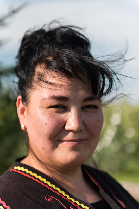
Khakas Woman, near Ankhakov, Khakassia Republic, Russia
Descending further the next morning, the Askiz Valley soon opens up into a broad, sweeping grassland fragrant with the smell of wormwood, which instantly recalls to me the wide steppes of Central Asia. Fed by the clear water of the Askiz, the valley is perfect pasture and is dotted with villages of livestock farmers; mostly Russians whose ancestors arrived here as early as the eighteenth century, though many are the descendants of twentieth century forced migrants. It’s no surprise however to find that the valley has long been inhabited by pastoralists and is rich with the relics of its Bronze Age and Iron Age inhabitants. These we find first just outside the village of Kazanovka, where the farmland is dotted with menhirs; large slabs of pink shale, sometimes solitary but often arranged in square arrays which may have been used for ritual purposes, as territorial markers, or as burial complexes. These rather mysterious constructions may be found across Eurasia and were common to many distinct though presumably related cultures. The Bronze Age people who carved these stones here Siberia are thought to have been speakers of early Indo-Iranian languages and it’s intriguing to think that they may have been closely related to the earliest Indo-Aryans, who penetrated the Indian Subcontinent and whose cattle-herding culture formed the basis of the ancient Vedic religion in which Hinduism is rooted. Many of the Bronze Age slabs have been re-used by later peoples such as those of the Tagar Culture who flourished here from the eighth century BCE to the third century CE; a race of settled livestock herders with European facial features.
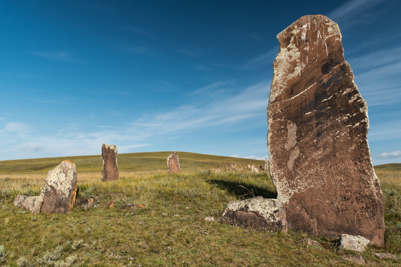
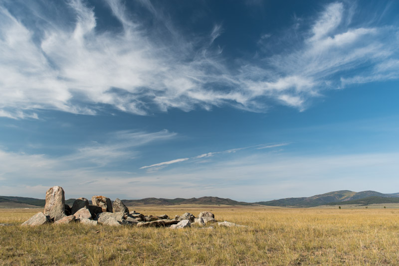
Menhirs, Safronov, Khakassia Republic, Russia
In the small, friendly town of Askiz we reach the A161 and turn south towards Tuva and the Mongolian border. The road follows the Abakan River through more beautiful, watered grasslands with occasional poplar trees dotting the river, and mixed villages of Russians and Khakass. In the late Bronze Age, pastoralist cultures of the Eurasian Steppe such as the Tagar came to be replaced by nomadic horse-men, ushering in a period in Eurasian history of nomadic invasions into ancient centres of settled civilisation; the Xiongnu into China, the Saka into Iran and the Huns into Rome. Here in Khakassia, the Tagars were displaced in around the third century CE by the Yenisei Kyrgyz or Khyagas; Turkic nomads, many of whom would migrate south to become modern Kyrgyz and whose local descendants are known today as the Khakass. We turn off the highway in the late afternoon and drive into the hills immediately above the village of Safronov, camping in an enchanting landscape of rolling grassland hills, backed by low mountains darkened by pine forest. After a beautifully tranquil night, we descend to Safronov’s menhirs; some of the largest in situ menhirs in the region. There are four distinct square-plan complexes, one with a single stone almost five metres in height, richly carved with Iron Age petroglyphs depicting human figures, shamanistic symbols and tribal tamgas. Their silent power, the weight of history which they represent, and their location out in this wonderful, soft landscape, with no fences or even signposts, makes them one of my favourite archaeological sites.
Abakan Valley, Khakassia Republic, Russia
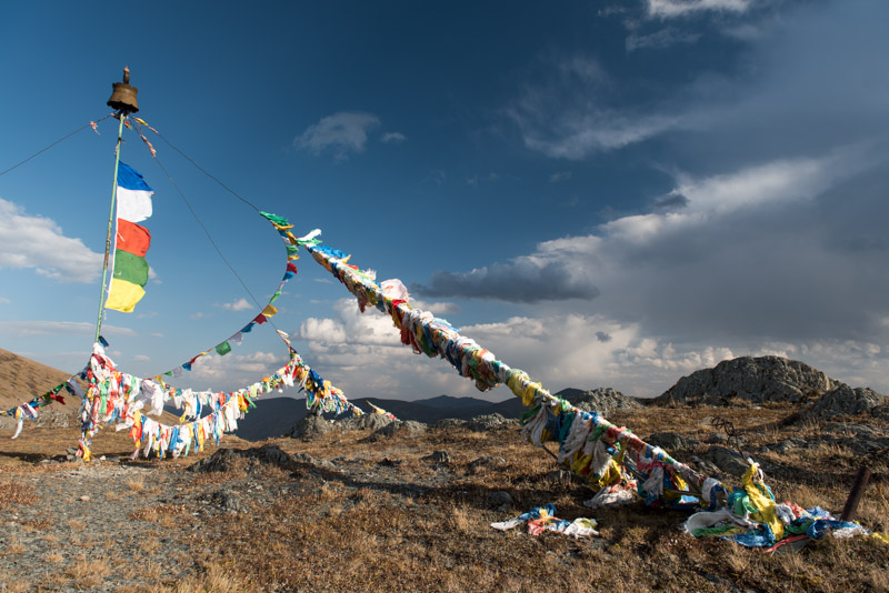
Rejoining the main road, we continue south, with the looming ridges of the Western Sayan Mountains rising on the horizon. We leave the grasslands and enter thickly forested mountains, stopping in the iron-mining town of Abaza to stock up on supplies, then climbing on the almost eerily quiet A161, passing the treeline and stopping on the 2207 m Sayan Pass, the border with the Republic of Tuva. A huge ovoo occupies the roadside on top of the pass; a central mast held by guy cables covered with Buddhist prayer flags which flap furiously in the strong wind. Beyond, darkened in the shadow of brooding clouds are the dark ridges of Tuva, a severely beautiful landscape and a place which fills me with both excitement and a a touch of terror. Back in 2007, on my very first trip to Russia I had entered Tuva on the glorious but tough off-road route from the Altai Republic and found Tuvans with whom I interacted in the west of the republic to be cold, hostile, drunk, aggressive and ultimately violent, leading to two young men attempting to mug me and hurling an apple-sized rock at my truck. Aside from the breathtaking scenery I came away from Tuva with rather negative impressions and so now, looking down once more to the wilds of western Tuva, I am nervous about our safety, but also anxious to have more positive impressions on this second visit.
Sayan Pass (2207 m), Tuva Republic, Russia
We drop into the pristine valley of the Ak-Sug River, which appears to be wholly unpopulated aside from a couple of roadside cafes. The area is said to have been depopulated because of lawlessness and cattle rustling, so we are very careful when picking a place to camp. We spot a track heading down to the river, which is completely concealed from the road by a thick swath of poplar and pine forest and after checking a few kilometres beyond the junction, we double back and slip into the forest, making sure no traffic sees us heading off the road. What we find is actually a most charming spot amongst the trees, next to the rushing cold water of the Ak-Sug were we spend the night completely undisturbed. In the morning we climb out of the forested valley over a small pass and drop into a new landscape, one of much dry steppe; a wide, open landscape very much reminiscent of Mongolia. Here we see our first yurts, known as ög in Tuvan, sitting beyond the calm Alash River in a small herder’s camp. After a lengthy stop at a police checkpost, we proceed across the plain and drop into Tuva’s second city, Ak-Dovurak, which was built up in Soviet times around a large, now barely functioning asbestos mine. There are a few cold stares from idle men, but otherwise Ak-Dovurak seems like a friendly small town, unchanged since Soviet times and populated by slightly rough looking men and astonishingly attractive, lithe young women.

Alash Valley, Tuva Republic, Russia
Tuvans are Turkic nomads who in terms of language and culture are closely related to Mongolians, typically practising Buddhism, though with strong animistic influences. Throughout history the land now known as Tuva has been a fairly marginal part of larger empires; Turkic, Mongol and from the late seventeenth century, Qing Dynasty (Manchu) China. Russian traders, gold-miners and Old Believers began to slowly colonise Tuva in the late nineteenth century and, following a 1911 rebellion against the Qing in China, Tuva sought to be free from Chinese domination, becoming part of Tsarist Russia in 1914. Following brief independence during the Russian Civil War, Tuva was incorporated into the USSR and closed to the outside world. In the Soviet period Tuva was decimated by forced collectivisation and communism, which replaced the age-old nomadic culture with the flawed ideals, corruption and economic incompetence of Marxism-Leninism.

Ustuu-Khuree, Tuva Republic, Russia
Driving out of Ak-Dovurak, we cross the rugged, sere landscapes of central Tuva, passing through the town of Chadan which is renowned for its violent crime rate and stopping at the tranquil Tibetan Buddhist monastery of Ustuu-Khuree. Built in 1905 in the waning years of Qing rule, Ustuu-Khuree was destroyed in 1937 as part of Stalin’s repressions against religion, which also saw much of the Buddhist (and other) clergy murdered or imprisoned. Recently a new temple has been constructed, with tapering, whitewashed walls and a yellow pagoda roof typical of the Tibetan style. The stout, mud-brick foundations of the original remain however, and seem somehow emblematic of the fate of Tuvans under the Soviet system. Detached from their traditional lifestyle with their culture deliberately destroyed, the Tuvans were plunged into poverty, later exacerbated by the collapse of the USSR and their physical and political isolation from the rest of the world. It’s perhaps understandable that there are undertones of aggression towards outsiders amongst the most marginalised elements of the population.

Yenisei Valley, Tuva Republic, Russia
We reach the Tuvan capital, Kyzyl, early in the evening and meet our hosts; Tuvan student Syldys, currently on a break from his studies in Moscow, and his father Mergen. I’ve been a little nervous throughout out journey through western Tuva but upon meeting our host family, I am instantly at ease. We drive together to the eastern edge of the city where the family lives in two comfortable wooden houses. We are fed by Syldys’ mother Sara, then head off with his father into the banya for a very welcome hot soak; the first hot water since leaving Novokuznetsk. Mergen is a retired chief of police and Syldys a student of criminology, so I am keen to relate my experiences in the west of the republic ten years ago. Mergen nods knowingly at the memories which I recall, telling me: ‘In the west the people can be crazy; they drink, smoke marijuana and lose their head. There are no Russians there and its pretty lawless. We are originally from the west of Tuva, but we are also very careful when we go there’. I’m somehow reassured by this; glad that my experiences and impressions were not unreasonable.

Bactrian Camels, Tes Valley, Tuva Republic, Russia
In the morning I collect a pre-arranged border permit from the border guards’ office and drive alone (Maciej’s late application has not been processed), south on the M54 towards the Mongolian border, a road I have wished to drive for many years. I pass through a mesmerising array of Tuvan landscapes, starting in the dry, grassy steppe south of Kyzyl, passing salt-fringed Lake Cheder-Khol, then climbing a ridge of thick forest with glowing yellow-leafed birches contrasting against the dark pines. Descending past the town of Samagaltay I enter a magnificent landscape of dry steppe as I meet the Tes River, which flows through this corner of Tuva from its source across the Mongolian border, to its end point in Lake Uvs, also in Mongolia. The river cuts a swath of greenery across the barren plains, dotted with more birches in riotous autumn colour. The road is perfect highway and practically empty and I cruise down towards the Mongolian border where the scenery becomes yet more spectacular, with dunes on the far side of the river spilling off across the border to distant mountain ranges which Maciej and I had driven through in winter, seven years ago.
Lake Tore-Khol, Tuva Republic, Russia
I stop at a pack of Bactrian camels, sitting in a tight clump at the roadside. Curious adults leave the pack to get a closer look at me, beautiful creatures in fine health with tall humps covered in ochre-coloured fur, while further back a calf muzzles its mother for milk. It’s a thoroughly stirring vista of high, inner Asia and for a moment I wish I could nip across the border to re-acquaint myself with Mongolia, but sadly the crossing is open only to Russians and Mongolians. The strangely perfect highway ends eleven kilometres from the border, so I turn around, backtracking to the town of Erzin and taking off on sandy tracks across the steppe. I cross the Tes on a concrete bridge and after asking directions from some friendly Tuvan tourists, head down to Lake Tore-Khol which straddles the border. I find a distant spot on the lake’s western edge and stop to camp for the night. The lake’s glossy, almost motionless water reflects perfectly the deep blue sky above me, with the golden sand dunes of the Tes Valley reduced to a thin line on the lake’s far shore. I am absolutely alone here and the area is totally silent apart from a distant flock of geese whose calls float gently across the lake’s surface. This ambience and stupendous scenery evoke in me a quite overwhelming sense of awe in the beauty of this planet and the grace of the natural world; my original and still primal motivation for travelling. It’s little wonder that the Tuvans, living in such a rich natural environment, retain their animistic traditions, offering prayers to the spirits of the mountains, rivers, trees, lakes, rocks, and see no boundary between human, animal and the inanimate, all being infused with the primal dynamism of the universe.

Wooden House, Shiryshtyk, Krasnoyarsk Territory, Russia
After a thoroughly regenerative night camping at the lakeside, I return to Kyzyl where we say our goodbyes to Syldys and his parents, and drive north on the M54. As we cross the Turan Plain and climb out of Tuva, I’m in high spirits. In addition to being thoroughly enchanted by Tuva’s gorgeous and ever-changing landscapes, this visit has reversed my negative impressions of Tuvan people; through meeting Syldys and his family, and through interacting with friendly, civil Tuvans in the east of the republic. It would be tempting to spend weeks slowly touring the republic, but I must keep in mind our ultimate goal; Magadan, still very far away. In the late afternoon we pass the dramatic, horned peaks of the Ergaki Mountains which unfortunately are mostly shrouded in cloud, then turn off the highway in Tanzybey and camp in a forest clearing. Now well out of Tuva, we are in an area of Russian settlements, with pretty wooden houses with coloured window-frames and kitchen gardens behind painted picket fences. Beyond the villages are large arable fields and a striking preponderance of mature, flowering cannabis plants growing along the roadside; something which might explain the rainbow-coloured local bus shelters. We spend the day on very quiet back-roads tracking north-eastwards towards the main Trans-Siberian Highway, nearly running out of fuel but joining the M53 in the afternoon without a problem. It’s almost one thousand kilometres, a distance which takes us a day and a half, heading south-eastwards through taiga and then farmland, passing the unappealing cities of Kansk and Tulun to Irkutsk, the largest city in eastern Siberia.
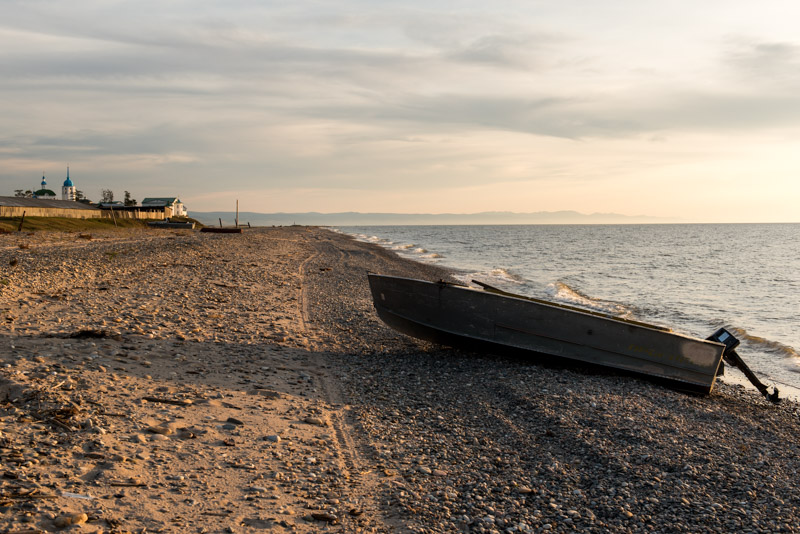
Lake Baikal, Posolskoye, Buryatia Republic, Russia
We spend an afternoon in Irkutsk and stay overnight with Nadia, a Buryat originally from further north in the province, who is about to relocate to Moscow, but we are falling behind our schedule and so, with plans to visit the city again next year, I make the decision to push on. Back on the highway, progress is slow as we negotiate the fringes of the Eastern Sayan Mountains overlooking Lake Baikal, not made any better by the region’s appalling drivers, the worst I have encountered anywhere in Russia. As we cross into the Republic of Buryatia, the traffic eases and we stop in Tankhoy to stand on the lake shore. A squall is coming in off the lake and the thrashing, steely-blue waters look very much like the sea, though the impression is somewhat odd as the drinkably clean lake water has no hint of a salty tang. By late afternoon we enter the swampy delta of the Selenga River and watch a glorious lakeside sunset from the village of Posolskoye, highlighting the spires of the village’s monastery and silhouetting a beached fleet of fishing boats against a deep red sky.

Gandan Darzhalin Monastery, Shuluta, Buryatia Republic, Russia
Long before the Trans-Siberian Railway, Posolskoye was the choice of landing point on Baikal’s eastern shore, and it was here that in 1651 Yerofey Zabolotsky, an envoy to the Mongols from the Russian crown, was murdered by local raiders. Thirty years later, the Holy Transfiguration Monastery was founded on the spot and while Posolskoye (the name deriving from the Russian for ambassador, posol) is now a sleepy village bypassed by all modern transport links, the large monastery remains. We enter the monastery grounds in the morning and are met by Nikolai, a priest with cropped hair, thick glasses and a mouth of gold crowns, who energetically shows us his well tended flower-garden and a simple ossuary where the skulls of former priests sit on an empty shelf. It’s a lovely spot, looking out over the vastness of Baikal.
We continue through the parkland and quaint villages of the delta, returning to the busy main highway only to drive to Ulan Ude, where after navigating the city’s rather arcane Soviet road network, we leave to take another back-road into the Uda Valley, a detour that will bring us to Chita without further using the M55. Leaving the environs of Ulan Ude, we enter a broad, beautiful valley of yellowing grass lined by distant forested ridges and an enormous blue sky. We turn off the road, driving to the village of Shuluta to visit the Gandan Darzhalin datsan or monastery, one of Buryatia’s few Buddhist monasteries to have survived the Soviet period which sits below a grassy hillside.
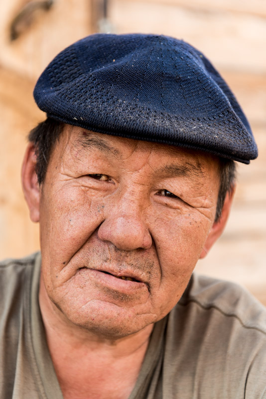
Buryat Man, Shuluta, Buryatia Republic, Russia
The Buryats are the major northern sub-group of the Mongols who inhabit the forested valleys east and west of Lake Baikal. Traditionally shamanistic, Buddhism spread among the Buryats from Mongolia in the seventeenth and eighteenth centuries, though it often came to coexist with, rather than replace, shamanistic beliefs. Russia formally annexed these territories in the seventeenth century, but it was only in Soviet times that the Buryats and their culture were repressed. Under Stalin tens of thousands of Buryats were murdered in an uprising against collectivisation and by the end of the 1930s the majority of monasteries had been closed and destroyed and the clergy murdered. Buryats to the west of Baikal have been strongly Russified, with some becoming Christians, but here, in the beautiful valleys beyond the lake’s eastern shore, the old traditions are slowly returning. Shuluta’s original datsan has survived Stalin’s Great Purge, though it is a formless shell awaiting restoration, but on a rise above it sits a beautiful, modern wooden temple, built in the Tibetan style and surrounded by a wooden fence hung with fluttering prayer flags. Just next to the temple is an unusual construction of multiple poplar sticks arrayed in a cross; a newly built ovoo hung with prayer rags in offering to the spirits that inhabit the place. There’s little activity in the temple, but we get chatting to a Buryat carpenter who tells us a little about the place, then takes Maciej’s palm and reads his fortune.
Uda Valley, Buryatia Republic, Russia
As we head deeper into the sun-drenched Uda Valley it becomes subtly more beautiful; the colours more vivid and autumnal, the settlements more widely spaced and the huge sky a gently deepening cerulean. At sunset the air is still warm and we stop to camp on top of a hill overlooking the valley, watching farmers cut the long, yellow grass in preparation for winter and hearing the distant singing of a cowherd following his cows back to a tiny nearby village; another lovely spot. We start at dawn the following morning in order to try to make up some time, but the road deteriorates to a rutted, unsurfaced track as we leave the beautiful valley and enter the taiga which here is being felled by most likely illegal logging companies to supply the nearby Chinese market. The bad road, dull scenery and my concerns at losing time make for a rather less than pleasant drive, but crossing out of Buryatia we encounter good asphalt once more and later, just north of the city of Chita, we join the M58, the highway which will take us eastwards to Khabarovsk.

Shilka Valley, Zabaikal Territory, Russia
We bypass Chita and enjoy the good asphalt of the highway, passing through taiga for two hundred kilometres before turning off the into the wide Shilka Valley, filled with gently rolling grassy hills. We camp for the night in a hillside meadow, watching a beautiful sunset over the gentle undulations of the wide, grassy valley, though we are slightly disturbed in the early hours by some nearby hunters in a Lada Niva shining spot-lights at us and later firing shots in the distance. In the morning we move off, soon reaching the banks of the Nercha River which marks the most easterly point I have ever visited; for me, the trip from here on is entirely breaking new ground. Across the river is the city of Nerchinsk, our last stop in eastern Siberia before the long journey into the Russian Far East. On first sight a slightly shabby, quiet country town, Nerchinsk is in fact of great historic importance and we head straight into the local museum as soon as it opens.

Butin Palace, Nerchinsk, Zabaikal Territory, Russia
This far flung and very sparsely populated edge of eastern Siberia was one of the last parts of Asia to be formally added to what is now Russia, by a set of treaties with Qing Dynasty China. The first of these treaties, the Treaty of Nerchinsk, was signed here in 1689 and formalised the border along the Argun River up until its juncture with the Shilka, where the two become the Amur. Beyond this, the border followed the Stanovoy Mountains in attempt to keep Cossack freebooters out of the Amur Basin. Having formalised the border, Nerchinsk became the chief centre of trade between Russia and China, until 1728 when trade was diverted through Kyakhta far to the west. Nevertheless, Nerchinsk continued to flourish, now on gold mining, using mostly exiles for labour. It is in fact in part of the palace of the local gold magnate Butin Family that the museum is now housed complete with the lavish nineteenth century furnishings. Among elegant chandeliers and gilded stucco mouldings are what at the time were reputedly the world’s largest mirrors, transported from Paris via the Pacific and Amur River to this wild outpost of eastern Siberia. It is indeed quite surreal to step from this Neoclassical refinement onto the streets of the lethargic town, which has other signs of long-past prosperity; some dank, crumbling trading arches, a boarded-up nineteenth century market and a red-brick structure overlooking the river which once received the town’s wine supply, but is now a shabby trade emporium.
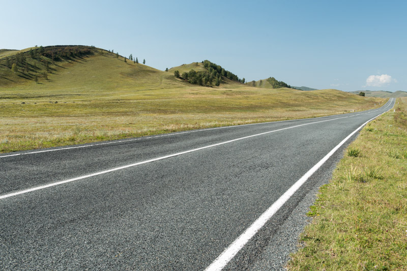
Nerchinsk is for us the last point of interest in eastern Siberia; beyond this lie more than a thousand kilometres of wilderness until we reach the city of Blagoveshchensk on the Amur River. We rejoin the M58 and begin the long journey on a perfect asphalt highway, one notable infrastructure project of modern Russia, for in Soviet times there was simply no road, with vehicles being loaded onto the train between nearby Chernyshevsk and Yerofey Pavlovich in Amur Region. It’s a joy to be able to make good progress with no distractions, looking out into the endless taiga which surrounds us on both sides as we round the northern-most bulge of Manchuria in China. Late in the afternoon we cross an administrative boundary into Amur Region, entering the Russian Far East and stopping to camp in a forest clearing.

Looking forward to more. Such a unique trip