
Stage 11 – India: Western Himalaya [2/2]

Having made the stunning and exotically beautiful journey to Leh by road, in the company of new-found travel partners, I would continue exploring the region before taking the eastbound route out of Ladakh, crossing into Muslim Baltistan, descending along the Line of Control, the de facto border with Pakistan, into the green mountains of Kashmir.

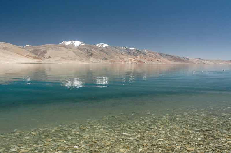
Pangong Tso, Jammu & Kashmir, India
On the 14th August 2008, Matjaz, Ana and myself make a journey to the nearby village of Taktok where there is a traditional Ladakhi Buddhist mask dance. The local Ladakhis are gentle, good spirited people, always bellowing the Tibetan greetings Jule! or Tashi Delek! when encountering another person, local or visitor alike. And the local religion, Buddhism, is in my opinion by far the most appealing of the major faiths, with its lack of dogma or outdated social prejudices. However, the rituals and architecture of Buddhism, a school of thought which in essence shuns ritual and material attachment, have never moved me in the way that for instance large communal evening prayers in open-air Persian mosques have. I leave the immediate area of the festivities and wander around the village, where I meet Nao, a pretty Japanese girl who accompanies the three of us back to Leh, where we spend the evening together.

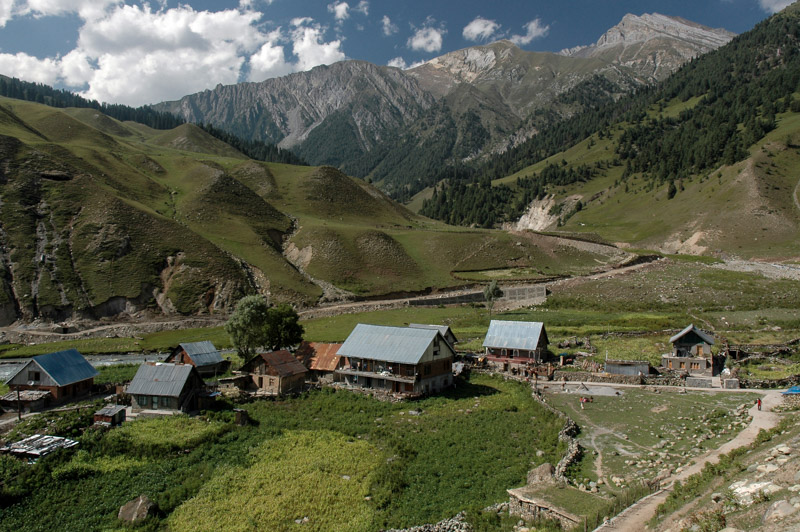
Sakti Valley, Jammu & Kashmir, India
Next day, Matjaz, Ana and I head east once again, toward Pangong Tso, another of Ladakh’s breath-taking high altitude lakes. Leaving Leh, we pass Taktok once more, beginning a long climb to cross the Chang La, which like Khardung La lies at a staggering altitude of 5,350 metres. On the far side of the pass, we help some stranded German hippies whose minibus has broken down at around four thousand metres, and don’t make it to the lake until the following morning. Making use of the cars, we leave the track and cross some steep and sandy dunes to find our own secluded lakeside campsite. We’re battered the following day by strong winds and rain, though on the second morning we wake early to see the lake as a perfect calm mirror reflecting the black, grey, buff and white hues of the mountains beyond, and the white clouds which start to boil from the damp hillsides. We sit out on our chairs drinking real coffee and smoking, looking out to the far end of the lake, which spreads east across the Changtang into disputed Aksai Chin. It’s not the first time in Ladakh that I sit back and think that I’m in the most beautiful place in the world.

Lamayuru, Jammu & Kashmir, India
During our third and final rest-stop in Leh, Christopher, the German cyclist, and Nao, both catch up with us, and the five of us head west, to the edges of Ladakh. After an overnight stop in the village of Alchi, where we camp in an apple orchard, we say goodbye for the last time to Christopher. We spend two days at the beautiful gompa in Lamayuru, whose building s spread up an entire eroded hillside, before following the Indus downstream as far as is possible, just twenty kilometres short of the Line of Control (cease-fire line), to the village of Dha. The Brokpa people of Dha look noticeably different from their Ladakhi neighbours, and linguistic similarities to ancient Vedic scriptures suggest that they may be remnants of the original Indo-Aryan settlers of India. The Brokpa are one of a number of distinct ethnic groups who are linked loosely by language, and are scattered across the Hindukush Mountains of Afghanistan and Pakistan, and here in Ladakh. These people have been termed Dards, and include the Nurestanis of Afghanistan, and the Kalasha people of Pakistan, who form an area known as Dardistan. Though the Brokpa have converted to Buddhism remnants of ancient pagan deities remain in their pantheon, and their villages of stone-walled houses are noticeably different from the Tibetan-style adobe houses of the Ladakhis. Their true origins remain an intriguing mystery.

Brokpa Dard Woman, Dha, Jammu & Kashmir, India
Returning from Dha to the main highway, we say farewell to Matjaz and Ana who have opted not to follow the road down to Srinagar in troubled Kashmir for security concerns. I’ve had some amazing experiences with the two Slovenians, and in their company have for the first time on the trip fully made use of the abilities of the car, both as an all-terrain vehicle, and as a home. Happily, I will meet them once again in Iran next February.
Nao and I cross two low passes on our way west into a stark and remote corner of Ladakh, and we’re reminded once more that centuries ago this rough provincial track was one of the great trade routes of Asia. In the village of Mulbekh, opposite one of the western-most gompas in Ladakh lies a huge rock-carving of Maitreya, the ‘future Buddha’ who will come to Earth as a successor of the original to teach the Dharma at a time that it has been forgotten. Dating most likely from the 8th century and set on an ancient trade route, generations of people must have passed and been moved by the grandeur of the sculpture, which through a dozen centuries has sat here and survived local shifts of empires and borders, and a transition from Buddhism to Hinduism and more recently to Islam. Soon the settlements begin to change in appearance; gone are the Ladakhi villages of whitewashed adobe houses amidst golden barley fields, apricot orchards and poplar tress, replaced by more austere villages of unadorned houses. Schoolgirls in white headscarves, colourful mosques and even a rather incongruous advertisement of Iranian Ayatollahs Khomeini and Khomenei sprout up as we enter the Muslim region of Baltistan which spans the contested boundary, extending well into Pakistan and occupying the very western reaches of the Himalaya.

Maitryea Carving, Mulbekh, Jammu & Kashmir, India
The drab town of Kargil is the first settlement of any size on the road, and with its endless rows of small shops and bearded men, feels very much like Pakistan, albeit a little cleaner and more orderly. Beyond Kargil, the road hugs the Line of Control, following the Dras River through a steep-sided valley, with the cease-fire line lying atop the cliffs on the far side of the road. At the roadside, a large yellow sign reads ‘WARNING – YOU ARE UNDER ENEMY OBSERVATION’. This rather inhospitable and windswept valley has a feel of military tension, and not long ago it was the site of full military deployment during the 1999 Kargil War with Pakistan. As we climb and pull away from the border, the landscape opens up into a beautiful, rather Central Asian scene of yellowing grasslands grazed by horses in the golden afternoon light, which picks out soft multicoloured mountains along the meandering river.
After stopping for a night in the town of Dras (which claims to be the second coldest town on Earth having recorded a temperature of -60ºC in January 1995), we cross the last ridge of the Great Himalaya via the rough Zoji La and descend into a wonderful green, wooded landscape reminiscent of Pakistan’s Swat Valley. Kashmir today is a name which in the Western mind conjures images of warfare and terrorism, but prior to the division of India, was an area renowned for its benign, alpine beauty. Since the mid 19th century, when the Sikh rulers of Kashmir were forced to join the British Empire, ‘Kashmir’ has referred to a far greater region, incorporating territory currently claimed and administered by India, Pakistan and China. Today it is one of the world’s most divided regions.

Dras Valley, Jammu & Kashmir, India
This princely state incorporated all the areas I have recently passed through since leaving the Spiti Valley, and a large swathe of northern Pakistan. At the time of partition in 1947, the incumbent on the Kashmiri throne, Hari Singh was given a choice between joining Pakistan or India. With a 77% Muslim population, the obvious choice was to join Pakistan, however when Singh hesitated, still clinging to dreams of maintaining an independent state, Muslim guerrillas infiltrated Kashmir from the Northwest Frontier, and a terrified Singh appealed to India for help. The Indians came to his aid on the condition that he accede to India, and in doing so he triggered the outbreak of the first Indo-Pakistan war, where army units on each side which had earlier in the year been part of the same force, took up arms against each other. With a history of feudal exploitation of the largely Muslim populace by Hindu landlords, Kashmir has remained a tense and volatile place since the birth of India it’s status awaiting a referendum which the Indian government has no desire to see happen.
Sonamarg, Jammu & Kashmir, India
In crossing the Zoji La, we have entered the real, historical Kashmir, or rather the Vale of Kashmir, a beautiful fertile plateau on the banks of the Jhelum River ringed by forested mountains. We stop in the small town of Sonamarg for lunch, finding that almost everything is closed due to the latest round of civil disturbances and army intervention which have placed the state capital Srinagar under curfew. We find an open restaurant where we are the only patrons, which is run by an ebullient Kashmiri with striking green eyes and a mullet. Kashmiris are renowned among Indians for their avarice and wiliness, and among foreign visitors for their promotion of vastly overpriced excursions to unseen houseboats on Srinagar’s Dal Lake, regardless of the current state of militancy in the city. It comes as no surprise then that he tells us of his houseboat on the lake, and of course it’s safe, it’s a lovely time to go to Srinagar, and that we mustn’t worry about the curfews / shootings / shops being closed, if only we’d care to pay him a deposit…

Gurjar Nomad, near Sonamarg, Jammu & Kashmir, India
Sonamarg is a deeply beautiful place; not in the way of Ladakh’s sublime high-altitude lakes, or of the highest snow-capped peaks of the Himalaya, but a gentle, comfortable greenery. Large wooden two-tiered houses with sloping roofs and balconies look strikingly European, as do the fair-skinned Kashmiris who have strikingly Aryan features. Scents of the pine forests send my senses reeling back to childhood summers in the Black Forest, and as we descend slowly through forests and sleepy villages of ripening maize and clear blue rivers, it’s difficult to believe it is India around us, and not the Carpathians. Near the village of Gagongir, we camp in a cool and fragrant forest clearing next to the Sind River, whose gentle burbling is interrupted only by the frequent army traffic. Occasionally, large family groups of nomads pass us as they move down from the mountains towards the plains. These deeply Aryan-looking people, their women wearing colourful headscarves, leading horses loaded with their tents and all other possessions, are like a vision of the original Aryan tribes who settled the bountiful plains of India millennia ago.
We descend further through more delightfully bucolic and un-Indian looking villages, until the valley starts to widen and fill with bright yellow-green paddy fields which produce the world famous Kashmiri rice. Here the villages become less attractive than those in the hills, with large, unfinished brick buildings which typify much of lowland Kashmir. Here also, the trouble starts. The area is under curfew, and the Indian Army – a force I have come to regard as being of unparalleled incompetence – are out on the streets, armed. Our presence is something of a shock to them, and each time we are stopped I must explain that we have come down from Leh, that we are tourists, and that we were unaware of the curfew, before we are waved on, only to be stopped minutes later. In one small town where all the street shop-fronts are boarded-up and barricaded, we are stopped three times in perhaps a kilometre. Passing a stranded Indian Army truck, I am about to nudge one soldier – who is standing oblivious in the middle of the road – with the front of the car to break him out of his trance-like stare, when one of his comrades pulls him out of the road and I merely clip the barrel of his rifle. It’s rather terrifying to be around such fools who are armed and loosed in the streets.

Sind River, Gagongir, Jammu & Kashmir, India
The current episode of tension stems ostensibly from a sacred Hindu pilgrimage site, the Amarnath Cave where a huge conical ice-stalagmite is worshipped by Hindus as the linga (penis) of the god of destruction Shiva. In granting a swathe of land around the cave (which lies in the upper reaches of Kashmir) for the annually visiting Hindu pilgrims, the authorities stoked the fires of separatism which (allegedly) erupted into civil disorder and violence. It’s difficult to separate fact from fiction in this region, but in the eyes of Kashmiri Muslims, is just the latest example of a long history of their domination by a Hindu majority. As well as the usual economic disruption, the district-wide curfew has a – perhaps premeditated – disastrous effect on the Kashmiri tourism industry.
Eventually we roll into the streets of Srinagar which is a city under a twenty-four hour curfew. The streets are ghostly-empty, devoid of traffic, all the shops closed, no shoppers. It’s very odd to be the only car on the streets, to drive around a completely dormant Indian city, though a unique and memorable experience. The atmosphere is tense, and we’re frequently stopped by the army and asked for curfew permits, which inevitably gives rise to the following conversation:
SOLDIER: ‘Where is your curfew permit?’
AUTHOR: ‘I don’t have one, we have just arrived from Ladakh’
SOLDIER: ‘You must obtain a curfew permit’
AUTHOR: ‘Please point us in the correct direction to obtain one’

Houseboats, Dal Lake, Srinagar, Jammu & Kashmir, India
Thus we slowly make our way across the city. We have no intention of course to partake in the bureaucratic ordeal of obtaining a permit, and so ask a civilian to direct us to Dal Lake. Upon arrival we are of course besieged by offers of accommodation on one of the lake’s iconic houseboats, and eventually take a room aboard the Long Melford, named after a Suffolk village.
The tradition of houseboats dates back to the end of 19th century when the Maharaja of the princely state of Kashmir, despite formally being part of the British Empire, outlawed the British from purchasing land in Kashmir. Kashmir was a land coveted by India’s colonial rulers for its European beauty and specifically as a cool summer retreat from the stifling heat of the plains. The British circumnavigated this restriction by purchasing houseboats – literally floating homes – on the tranquil waters of Dal Lake. As Collins & Lapierre describe in their epic novel Freedom At Midnight, the retired colonels and civil servants lived ‘…[an] untroubled existence in a paradise of sunshine and flowers, where a man could live the dream of the Emperor Jehangir on thirty pounds sterling a month’. The Long Melford harks back to this age, and though the current craft is a 1980s reconstruction, the owner of the boat, a mild-mannered Kashmiri who seems exasperated by the endless conflict and near death of the tourist trade, shows us a folder of letters of recommendation and appraisal which go back as far as 1914. Old black and white pictures show elegantly dressed sahibs and memsahibs relaxing on the boat, and the current owner’s forebears decked out in gleaming white turbans and smart uniforms; today the owners (and clients) are considerably less well-dressed.

Shikara, Dal Lake, Srinagar, Jammu & Kashmir, India
Though it may now lack the pomp of the bygone era, staying on the houseboat is a uniquely relaxing and decadant experience. Meals are brought to us three times a day, which may be enjoyed in the bedroom or on the boat’s open terrace. There’s little else to do, as one cannot venture into town at any time, save for an hour in the afternoon when everyone flocks the streets to shop. Our Kashmiri friend in Sonamarg seems to have been right; with the curfew in place, now really is a great time to visit, as the natural tranquillity of the lake is complimented by the lack of a background of city noise. Lying in our bedroom, looking out onto the mirror-like waters of the lake which are dotted with stationary houseboats and smaller shikaras which locals paddle round for transport to the lake’s far shore, one becomes positively serene. One hears only the gentle sounds of life on the lake; small craft floating past, sometimes containing whole families, snippets of caught conversation, the squawking of wheeling seabirds and fish eagles which hover above, and the distant clamour of the mosques, from where the sound of singing wafts across the water from dawn until sunrise and again in the evening. All these sounds come to life without the usual Indian sounds of manic traffic, horns and the hubbub of throngs of people; even the dogs seem to have given up their incessant barking. How wonderful India is under curfew!
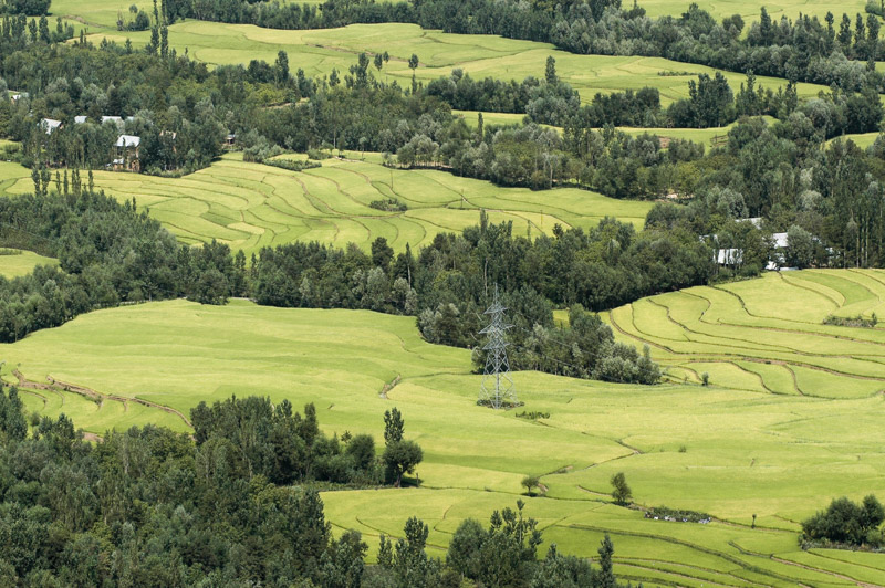
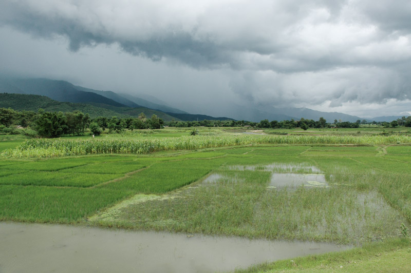
Rice Fields, near Anantnag, Jammu & Kashmir, India
The inevitable time comes however, after three of the most relaxing and restorative days of my life, for us to move on. Say a fond farewell to the Long Melford and her owner, we head back onto the tense streets and make our way across town, always on the pretence of being on our way to the appropriate office from which to obtain a curfew permit. Resuming our journey south, the roads are once again quiet though the traffic increases slightly with distance from Srinagar. The roads are full of police and army, and lined with people hoping to hitch a lift; one wonders how long they have been waiting for the curfew to be lifted and for normal life to resume. Leaving the southern edge of the Vale of Kashmir, we start to climb into the Pir Panjal Range, from where the vale spreads out in a magnificent tongue of textured, vivid green rice paddies. Passing through the unlit two-and-a-half kilometre Jawahar Tunnel, we leave Kashmir proper and wind down through quite heavily populated rolling green hills. After the magnificence of Ladakh and Kashmir, the hills are rather uninteresting and views are once again obscured by the last of the season’s monsoonal clouds. We roll out of the last outriders of the Indian Himalaya on a long descent, finally re-joining lowland India in the unexciting town of Jammu, just thirty kilometres from the (formal) Pakistani border. The town is not under curfew, but there is a general strike of the predominantly Hindu population.
Next morning I’m awoken by the sound of explosions, which turn out just to be firecrackers from some demonstration or other. The police have set up a number of roadblocks at the edges of the city, and it takes some time (and a penknife to cut through one roll of barbed wire blocking the road near the hotel), and a few arguments with the police before I find a way out. We don’t get far before we’re delayed for several hours by the Indian Army, who are trying to organise a roadblock at the city’s edge in anticipation of a VIP convoy. It’s not until evening that we reach the city of Pathankot, just over the state border in Punjab, where we spend our final night together. Tomorrow Nao will leave east for Dharamsala, the home-in-exile of the Dalai Lama, and on to Delhi to obtain a Pakistani visa, whilst I will head more directly back to my favourite country, where we hope to meet next month.
Without the responsibility of a passenger, my final drive in India, an almost straight one-hundred kilometre dash across the Punjabi plains back to the city of Amritsar, is an orgy of automotive aggression in which I have a final chance to vent all my frustration at India. I use the full potential of the truck’s size, muscling into the heavy car traffic from a side road, and overtaking lorries straight into oncoming motorcyclists and bicycles. As I force one motorcyclist to hit his brakes and leave the road, clinging onto his machine for dear life as it flies over the rough un-made surface, I catch the look on his face. It’s not one of mortal anger – as it would be were I in his shoes – but a smile. It’s as if he is vindicating my recklessness, an admonition that I have finally understood the philosophy of driving (and more) in his country.
I spend four days with my friend Alvin in Amritsar, staying once more in his comfortable hotel suite just as I did very nearly six months ago upon entering India for the first time. My journey has taken me to the very far edge of the subcontinent and back, a great swathe of people, cultures, landscapes, religions and ideas. While India can be frustrating – strangely far more so than Pakistan, Bangladesh or Nepal – it is a staggeringly diverse and fascinating place. Although at this time I feel I’ve seen more than enough of the country, deep down I know, sooner or later, I will feel the urge to return; to the outer states of the north-east, the strongly Muslim region of Gujarat, which borders my beloved Sindh, and the tribal states of the central Deccan. Firstly however, I will continue my journey through the mountains, before moving back towards Europe as the year ends.
Stage 11 – India: Western Himalaya [1/2]
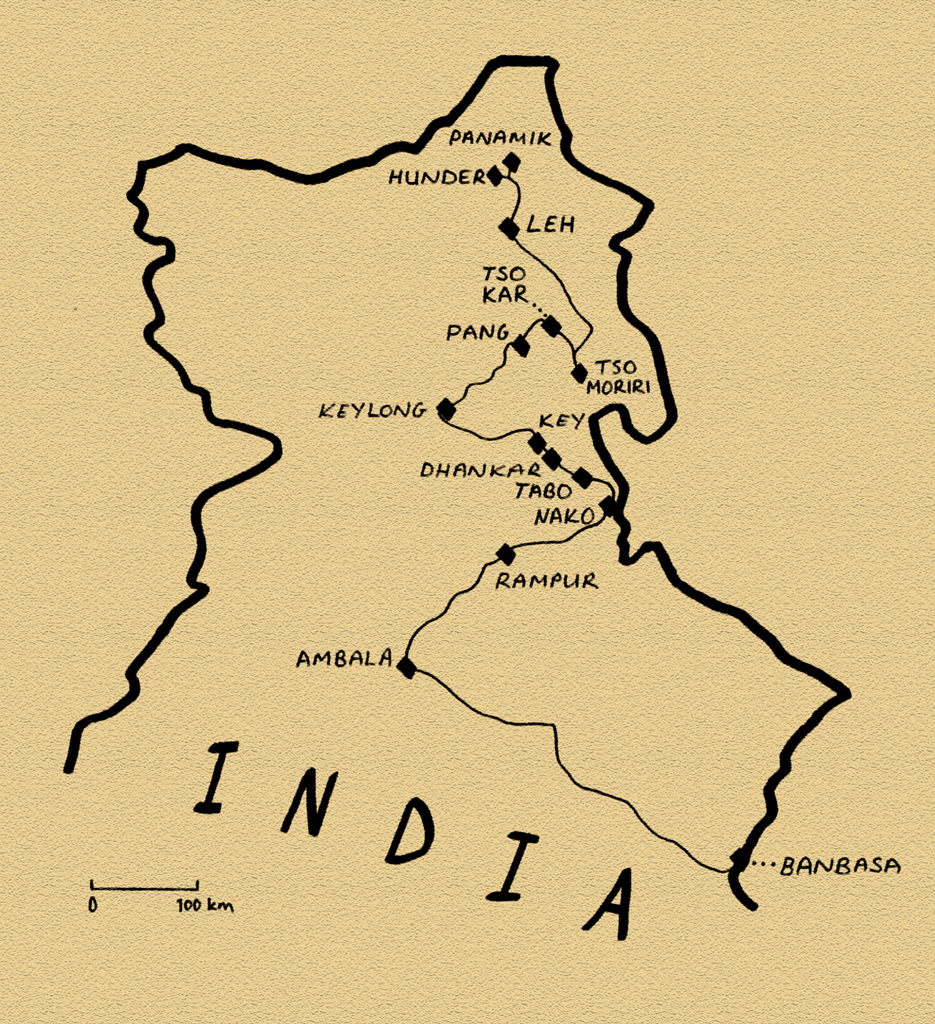 The Tibetan Plateau is a huge upland area which lies in the Trans-Himalaya, that is, from a southerly perspective, the area beyond the Himalaya. As the Indian Subcontinent relentlessly ploughs into the rest of Eurasia, giving birth to the Himalaya, this vast plateau has been uniformly uplifted to altitudes of up to five thousand metres. This stark, high and dry region, lying in the rain-shadow of the world’s greatest mountain range, is a land of sublime and other-worldly landscapes; huge open vistas of rolling mountain steppe, fantastically deep-blue skies dotted with ranks of puffy cumulus clouds, and crystal clear high-altitude lakes. Sadly, much of the Tibetan Plateau lies within the boundaries of modern-day China, a country where one cannot move freely with one’s own vehicle. But a small section of it, the former Buddhist kingdom of Ladakh, lies within the boundaries of modern India, and will be the focus of this third visit to the country.

Sutlej Valley, Himachal Pradesh, India
It’s the 17th July 2008 and I’ve just left Nepal to enter India for the third and final time on this journey. I enter the southern reaches of the mountainous state of Uttarakhand during heavy monsoonal rain. Against the deep shades-of-grey sky, the brilliant landscape, shimmering with new fertility brought on by the monsoon, is green-upon-green-upon-green. As I head ever closer to the holy city of Haridwar, huge numbers of trucks occupy the road, slowing down the traffic and muscling past each other with no regard for other road users. In one town, where the traffic stops, a man stands outside my open window, staring in at me blankly like a horror-film zombie. It’s a rude welcome to India after the solitude of the Himalayan trails in Nepal. Darkness falls as I enter the industrial state of Haryana where many of the trucks are heading, and I stop for the night near the town of Ambala. In the morning, I head up once more into the foothills of the Himalaya, to the mountainous state of Himachal Pradesh, passing the hill station of Shimla, crossing the first major ridge and dropping down to the Sutlej Valley.
The road up the valley of the Sutlej, one of the five rivers of the Punjab, is quite a feat of engineering. In many places it has been blasted from a sheer rock face, and winds along the near-vertical valley walls, hundreds of metres above the raging white-water of the river. The road follows the river upstream almost all the way to the Tibetan border, with the valley becoming ever drier and more spectacular as it climbs further from the monsoon-swept plains of lowland India. A few kilometres from the frontier, in a huge brown-grey valley of yawning alluvial hills utterly devoid of vegetation, vastly complex, twisted, tortutred geological strata in the rock exposures attest to a violent recent history. This is the Himalayan suture zone where the Indian Subcontinent met Eurasia roughly fifty million years ago, and continues to do so today. At this point the road turns due north into the Trans-Himalaya, entering the Spiti Valley, through which it will climb to the edge of the Tibetan Plateau.

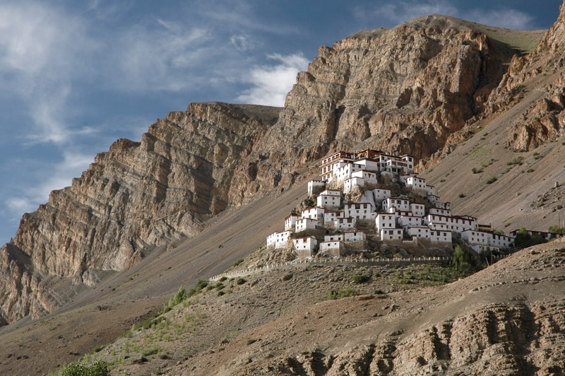
Dhankar Gompa, Himachal Pradesh, India
As well as marking the tectonic boundary, my entry into the Spiti Valley marks the transition from an area which is culturally Indian, to one which is culturally Tibetan. Buddhist chortens (mound-like structures containing Buddhist relics) start to dot the landscapes, standing out brilliant white in the intense sunshine, against the intrinsic dusty-grey of the bleak surrounding hillsides. In the village of Nako, which sits around a deep-blue lake on a green ledge high above the canyon of the Spiti River, I meet a number of other overlanders; Slovenians Matjaz and Ana in a 4×4, Christoph, a Swiss motorcyclist, Germans Kari and Werner in a 4×4 Unimog camper conversion (which was too large to progress any further up the road, and who I would meet again in Pakistan the following year), and a German cyclist, Christopher. The five of us travel together for a few days up the valley, which becomes ever more beautiful. We Camp together each evening, cooking communal meals, and enjoying the freedom our vehicles give us in this magnificently remote extremity of India.
Key Gompa, Himachal Pradesh, India
Like many of the inhabited areas of the Tibetan Plateau, hidden away from the outside world throughout much of history, the immense, forbidding mountains of Spiti are dotted with gompas, Tibetan monasteries of the Mahayana School of Buddhism, which are an almost intrinsic part of the Trans-Himalayan landscape. Tabo Gompa, the largest of the Spiti Valley, will be the retirement place of the Dalai Lama, should he choose to retire from his public activities. The nearby 12th century Dhankar Gompa, the next in the valley, is a fantastic mixture of nature and architecture where the dozen or so religious buildings, brilliant white with crimson roofs and window-frames, nestle like eagles’ nests amongst bizarre finger-like protrusions of soft tuff which hover over the yawning valley. In these fantasy-like settings, generations of monks have devoted their lives to the teachings of the Buddha, renouncing the ways of the world in a hermetic life which seems to compliment the natural austerity of the region, far from the seething crowds of India.
The eleventh century gompa at Key however, is perhaps the most spectacular in Spiti. Dozens of boxy whitewashed temples and meditation cells surround a central monastery, all spread around the conical slopes of a rocky outcrop hanging at almost four thousand metres on the valley-side. Key is an incredible sight, surely one of the world’s most striking architectural complexes.

Changpa Nomad, More Plains, Jammu & Kashmir, India
Next day, Matjaz, Ana and I say goodbye to cyclist Christopher (who will not be able to match our pace), and motorcyclist Christoph (whose pace we will not be able to match), and begin our journey west and then north into Ladakh proper. Crossing the rough, 4,500-metre Kunzun La (pass), we drop down into the district of Lahaul, which is immediately greener, more populated, and less attractive. We make slow but steady progress on the ever-deteriorating roads, first over the 4,900-metre Baralocha La, then into the state of Jammu & Kashmir, winding the cars up to just over five kilometres above sea-level on the endless climb of the Lachalung La. At these altitudes, higher than the summit of any peak in the Alps, the car struggles in the airless altitude, and any significant incline reduces progress to first of second gear. This is the infamous Manali to Leh Highway, built in the 1950’s and allowing surface access to Ladakh from July to October. Although its existence is strategic; due to the need for supplies to be taken up to the frontline of India’s tense standoff with Pakistan and China in the upper reaches of Kashmir, since the 1970s it has been open to foreign travellers, and now sees a steady stream of tourists.
Shortly after the military garrison of Pang, we reach the wide open More Plains, a dusty, desolate flatland which sits between the encircling ranges of mountains. We have reached the Tibetan Plateau proper, the eastern reaches of the huge Changtang which stretches sixteen hundred kilometres, deep into Tibet. Incredibly, out here in this most desolate and rarefied environment, we meet two Changpa nomads herding a surprising number of sheep and goats on foot. One of them asks me for some water, giving me a chance to study him; a stocky Mongol with skin darkened from such high-altitude exposure, his face and lifestyle hark back to the days of Chinggis Khan and the great Mongol hordes.

Wild Ass, Tso Kar, Jammu & Kashmir, India
On these windswept More Plains, a set of dusty tracks head east from the main road to a broad basin, at the centre of which lies the turquoise lake Tso Kar, ringed by soda pans and coarse, brackish grassland on which the three of us camp. To the south are the smooth, undulating ridges of the Zanskar Mountains, whose six thousand-metre peaks look from our elevated perspective to be mere hills. Despite the thin atmosphere, blinding soda pans and fetid, brackish water, the area is far from sterile. The lush grass, though sparse, spreads in a rich green carpet to the foot of the mountains. From the dusty, desiccated earth, marmots dig their burrows, watching us carefully on their hind legs, their front paws held passive on their bellies, with faces like giant guinea pigs. From the grass, early in the morning, larks rise high and unseen into the sky, and the calls of numerous wildfowl on the lake are the only sounds to pierce the stark, deafening silence. In the far distance a kiang, a Tibetan wild ass, its body a two-tone of brown and cream and with a noticeably larger head than a domestic ass, makes his way down to the water’s edge. It’s a sublimely beautiful environment; starkly beautiful, yet benign and comfortable at the same time. These high grasslands, so quintessential of the rolling upland plateaus of inner Asia, are almost certainly my favourite environment. Camping here with friends, totally independent with our cars, is one of the greatest of life’s pleasures. The three of us camp in such a manner day after day, cooking breakfast and dinner in the lee between our cars, sitting out drinking coffee in the most magnificent of landscapes. The sense of independence and isolation is fantastic, and the outside world seems to slowly pull away from our minds.
Tso Moriri, Jammu & Kashmir, India
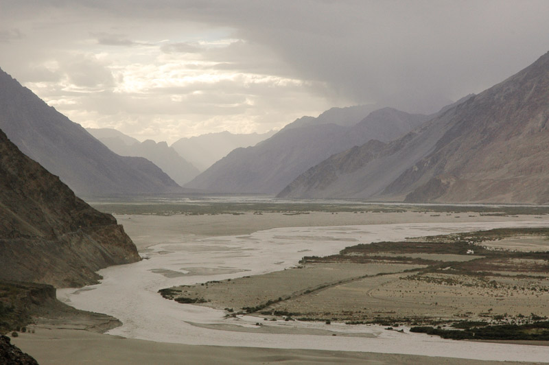
We spend two nights at Tso Kar, before pushing further east into the wilds, passing the tents of more Changpa nomads, who may very well be the strongest-smelling people I’ve encountered. We cross another pass, passing the magnificent Tazang Tso, pushing on to mirror-like Tso Moriri, where we strike another idyllic lakeside camp, watching jeep-loads of tourists who stop a few hundred metres from us for a compulsory two-minute photo stop, before heading on to the rather squalid lakeside settlement of Korzok. North of here, we descend through a purple-rock canyon to reach a river very dear to my heart: the Indus. Freshly arrived from its Tibetan headwaters, the river is small and milky from glacial inputs, and altogether different from the muddy, slow moving giant which I last saw in Sindh, five months ago.
We re-join the main Manali – Leh highway in Upshi, a squalid truckstop set among vast barracks of the Indian Army which mar the landscape for several kilometres, and move north to the Ladakhi capital of Leh. The road passes through villages of unrendered mud-brick walls, behind which are rows of elegant poplars now releasing their cotton in great blizzards, irrigation canals and clouds of tangy woodsmoke. My thoughts are immediately moved to think of Central Asia; of the backstreets of Samarkand or Kashgar and the ancient trade routes which crisscrossed high Asia. Shortly after, we pass on our right Thikse Gompa, the largest in Ladakh, which like a scaled-down Potala Palace transports the mind to Tibet. Despite its marvelous isolation, Ladakh is very much a crossroads of cultures.
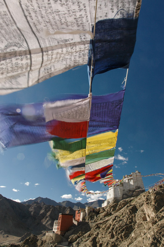
Prayer Flags, Leh, Jammu & Kashmir, India
Leh, the capital of the former Himalayan Kingdom has historically been a crossroads on trade routes which linked India, Central Asia, and Tibet. Today it remains a curious mix of these three Asian cultures, which comes as something as a surprise given its considerable isolation; a city inaccessible by any means other than air from November to June. The native Ladakhis look to be straight out of the mountains of Tibet, though they seem to be outnumbered in the city by Kashmiris from the southeast, who bring to the city a palpable Muslim presence; black beards and white topis (hats), and the sound of the azan (call to prayer), which competes with the chants which emanate from the city’s temples and monasteries. Sikhs, mostly shopkeepers and lorry drivers, wearing colourful turbans add to the kaleidoscope of humanity one sees here. Both these groups can trace their origins in Leh to the annexation of Ladakh by Kashmir in the mid 19th Century, though what draws many to the city, a city which practically shuts-down in winter, are the tourists who make up a considerable proportion of the town’s summertime inhabitants.
Leh seems to attract particular types of tourist; those that favour baggy orange trousers, though there are also plenty of middle-aged European tour groups, and Israelis, who zoom around town on hired or purchased Enfield motorcycles. Indeed, the low, single-cylinder throbbing of these archaic British motorcycles seems as much a part of the aural ambience of Leh as the sounds of Buddhist mantras wafting from tourist restaurants and the afterburners of the Indian Air Force’s MiGs and Sukhois which scream overhead from the airstrip on the town’s outskirts. Yet despite all the tourists, trekking shops, curio stalls, kerbside cobblers, German bakeries, rooftop pizza restaurants, motorcycle hire outfits, Bihari beggars, alternative medicine clinics, massage parlours, drum salesmen and bookshops, the town’s relaxed Buddhist-cum-Muslim atmosphere is decidedly hassle-free when compared to India’s other backpacker hubs. However, with the prospect of more wilderness camping, Leh is little more than a rest and refuelling stop before we alter our border permits with a pen and resume our journey north.
Shyok Valley, Jammu & Kashmir, India
Due north of Leh, a road winds across the Ladakh Mountains, over a low defile known as Khardung La, which at 5,360 metres is the highest road I have driven on (the Indians falsely advertise it as the highest road in the world), a fantastic altitude which is just twenty metres lower than the mountain I climbed in Nepal in order to view Everest. Groups of unfortunate Bihari road-workers in the employ of the Border Roads Organisation fight a losing battle against the streams of meltwater which cascade endlessly down the unsurfaced upper reaches of the pass, from where the view is rather an anticlimax. North of the pass, the road descends through dramatically eroded lunar mountains dotted with villages of brilliant green barley fields, to the Shyok Valley. On our way down, we are held up by the Indian Army, who, through astounding incompetence have managed to get two of their trucks travelling in opposite directions wedged on a sharp mountain bend, high above the Shyok Valley. As the two officers argue over who is to blame, and who should move first, one wonders how such fools could ever conduct a military campaign. It’s also a reminder that this is a highly sensitive military area, bounded by long-disputed borders with two nuclear superpowers, with both of whom India has engaged in armed conflict. Following the Shyok River downstream to the west would lead one to the Line of Control, the hotly contested cease-fire line with Pakistan, while to the north the Nubra Valley leads to the world’s highest battleground, the Siachen Glacier, and the Shyok Valley leads upstream to the disputed border with the Chinese-occupied area of Aksai Chin, where India fought a war in 1962. To date none of these borders have been ratified, with India making territorial claims in all directions.
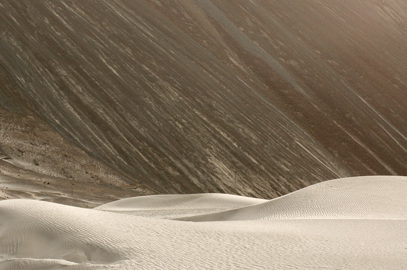
Sand Dunes, Hunder, Jammu & Kashmir, India
Having passed the blithering Indian Army, we descend to an environment quite different from the Chagtang of Ladakh. We camp overnight in an apricot orchard in the village of Diskit, before moving as far east as is possible for foreigners, the village of Hunder. Hunder is a sprawling village of apricot orchards, clear river-water running in irrigation channels, and dry stone walls topped by thorny bushes which grow in the gravely alluvial deposits, all of which make it far more reminiscent of the Wakhan Valley in Tajikistan or Pakistan’s Hunza Valley than the sere landscapes of Ladakh. Beyond the village, the broad river valley where the Nubra River joins the Shyok is filled with fluvial sand, which has been whipped into smooth, sensual dunes by strong winds which come from Tibet in the east. We camp in amongst these dunes, a strange mini-desert within the stark mountains, near a group of Czech tourists, whom we befriend. In the company of my Slovenian travel-partners, and the group of four Czechs who sit around a campfire playing music and singing, I’m reminded up here in the austerity of the high Himalaya of the great warmth of the Slavic soul, and I appreciate more than ever the sense of absolute freedom in this fantastic landscape.
Stage 10 – India & Nepal: Central Himalaya [2/2]
 The fabled mountain kingdom of Nepal is a country in transition; In 2006 the Maoists, who had led a decade-long communist insurgency were formally integrated into the Nepali Government. Less than two weeks before my arrival, King Gyanendra was constitutionally forced to abdicate thus transforming Nepal into a republic. On my third day in the country, the former king, a man accused of widespread embezzlement, makes an emotional plea to the impoverished populace of this backward Himalayan state and vacates his huge, opulent Narayanhiti Palace in the capital. None of this would impact my plans in Nepal; which were to trek up amongst the highest peaks on the planet. Here, amidst long-awaited glimpses of the lofty Himalaya beyond the broiling monsoonal clouds, I would see a country still barely touched by modernity, passing through villages disconnected from any modern infrastructure whatsoever. It would be an uplifting and eye-opening trip beyond the frantic roads and cities of the subcontinent.
Bodh Nath Stupa, Kathmandu, Bagmati Zone, Nepal
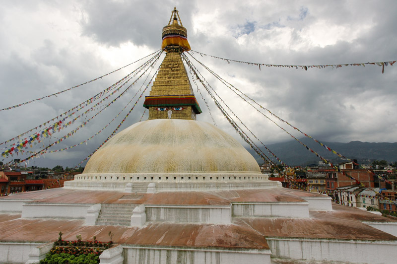
In the morning of the 28th May 2008, I cross into Nepal at its easternmost point and drive directly up into the foothills, reaching the capital well after dark. Kathmandu, as the capital of a famously beautiful and exotic country, is rather a mundane place, though not unpleasant. It’s less squalid than most of the subcontinent’s major cities, with a free-market air, and a noticeable presence of many western aid and development organisations. The city is surrounded by a backdrop of rolling green hills and distant snowpeaks, now almost permanently obscured by the haze and clouds of the monsoon. There’s a noticeable air of religious tolerance here, and indeed the country itself is a land where Hinduism and Buddhism sit easily side-by-side. The city’s most iconic building is the 8th century Boudhanath Stupa, painted with the all-seeing eyes of the Buddha and festooned with prayer flags. Across the city in Durbar Square are a collection of ancient Hindu temples dedicated to various deities, including a striking idol of the Hindu deity Kali, goddess of power and consort of Shiva. Here the air is alive with incense among distinctive Nepali architecture; red-brick temples with multi-tiered timber roofs.
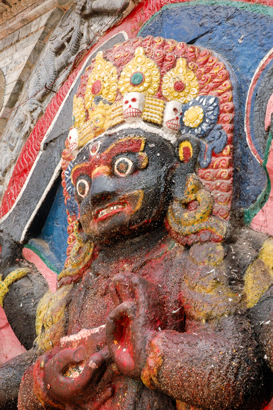
Kali Idol, Kathmandu, Bagmati Zone, Nepal
But it is the people of Kathmandu who are in my opinion, its greatest attraction. Unfalteringly friendly and welcoming, despite the concentration of tourists, and are an attractive mix of the two great swathes of humanity which meet in the Himalaya; Indo-Aryan face from the south, blending into lighter-skinned, round-faced Nepalis, to Tibetans with their high cheekbones and pink-tinged cheeks. There’s little of the usual hassle of India, no crowds of vacant starers, and even the beggars, who seem all to be dark-skinned Biharis, the archetypal beggars of the subcontinent (I never saw a Nepali or Tibetan begging) are gentler than in India.
The city draws huge numbers of tourists, and has done so since the Asian overland trails started in the 1960’s, who flock to the central district of Thamel, a veritable tourist ghetto set along ‘Freak Street’. Thankfully, I’ve found accommodation with an American volunteer, Mario, in the largely foreigner-free district of Handigaon. It’s in a shop here that by chance I meet Liam, a Welsh ex-pat who runs a UK internet cosmetics business from his Handigaon flat. Over plates of buff (buffalo) chow mien, and cans of Nepali-made San Miguel lager, he tells me a story which exemplifies the anger people feel towards their decadent former royal family, and a story which is sadly not unusual amongst the rich-and-powerful of South Asia. One of the King’s sons was in a nightclub owned by a friend of his. He noticed someone had written something on his car, and, fetching a shotgun from the car boot, shot wildly in one of the club’s bars, sped off in his car (drunk), killing a Nepali actress. He was duly arrested and detained, but the following day released without charge. Similar stories abound of Indian film stars, and Pakistani landowners.
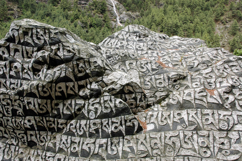
Tibetan Carvings, Phakding, Sagamartha Zone, Nepal
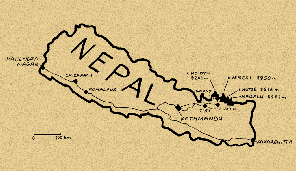
My reason for coming to Nepal however is to see more of the world’s tallest mountains, far to the north in the district of Solu Khumbu, or simply the ‘Everest Region’. One very noticeable aspect of Nepal having not been part of colonial British India is a glaring lack of infrastructure. Everest is almost two weeks’ walk from the very last town accessible by road, and so I decide to save around ten days of walking by flying from Kathmandu to the airstrip in the Sherpa village of Lukla. Kathmandu’s domestic airport has the air of a bus station, with frequent arrivals and departures of small propeller aircraft, which are the only means other than walking, of reaching many parts of the country. After an interminable wait, and thirty minutes after what was meant to be the cut-off time, my flight is called and I board the small Dornier turboprop aircraft. There are fifteen passengers aboard, of whom three are foreigners, and one very attractive stewardess who hands out small wads of cotton wool for the purpose of plugging ones ears against the drone of the propellers, and small toffees. She takes the pilot a Snickers bar and something wrapped in an air-sickness bag, presumably not vomit. We fly just above the boiling froth of monsoon clouds, only once glimpsing a distant peak to the north very briefly. Once again I hope that the clouds won’t prevent me from seeing the mountains throughout the trip. The landing at Lukla is memorable; the aircraft lands heavily at the bottom of a steeply inclined asphalt airstrip (one wonders how the asphalt was brought here), which hovers above an abyssal valley. At the top of the airstrip, it seems the aircraft will crash straight into the mountainside, but swerves at the last moment sharply to the right and comes to a stop neatly outside the stone-walled terminal building.

Gokyo Valley, Sagamartha Zone, Nepal
Nepal is in many way’s the world’s best country in which to trek. In a country where perhaps 50% of the population must walk a day or more from the nearest roadhead to reach their homes, the country’s well-worn mountain trails are lined with facilities which preclude the necessity for guides, porters, cooks, pack animals, tents, cooking facilities, and even food. This makes trekking here extremely affordable and accessible, though of course this draws vast numbers of foreign trekkers, who swarm certain routes transforming these service trails into tourist trails. By coming in the monsoon season however, one escapes the choking crowds, and can have a totally different experience of the mountains. The drawback of course, is catching only fleeting glimpses of the mountain grandeur which lies behind the banks of swirling cloud. Once again, the undertaking is a gamble; risking missing the views in return for missing the crowds. As I enter Sagamartha (the Nepali name of Everest) National Park, I notice a visitor logbook. Last October (the peak season), the gate counted 7,750 foreign visitors, whereas one year ago, in the month of June, just 284. Further to this, I’ll be heading up the less-visited Gokyo Valley rather than heading straight to Everest Base Camp (where one cannot see the summit of the mountain anyhow).

Yak, Gokyo Valley, Sagamartha Zone, Nepal
I make the ascent from Lukla to the trail-end at Gokyo in a leisurely six days, ensuring that I acclimatise sufficiently to climb the final peak, well above five thousand metres, from where I hope to see four ‘eight-thousanders’ including Everest. I have a rest-day in the damp Sherpa town of Namche, the ‘capital’ of Solu-Khumbu, and a town where, at a distance of at least seven days’ walk from the roadhead, almost everything is brought on the back of the local Sherpas who can be seen slowly ascending the steep, rocky trails carrying loads which often exceed them in terms of sheer size, and almost always in terms of weight. I meet one diminutive Sherpa whom I estimate to weigh around fifty-five to sixty kilograms, who is carrying ninety kilograms of bottled lager on his back, in a load which towers above him. The landscape is quite similar to that in Sikkim, though less attractive without the huge rhododendron forests. The area is far more heavily settled, with extensive terraced farming and occasional grazing yaks. Traditional stone-walled dwellings are mixed with more modern ‘teahouses’, which serve as hotels and restaurants to trekkers, and at present are almost all empty.

Ngozumpa Glacier and Gokyo Lakes, Sagamartha Zone, Nepal
The last, steep stage to Gokyo passes the terminal moraine of the Ngozumpa Glacier, the largest in the Himalaya, where a violent tongue of milky brown water cascades from the tongue of dirty-brown rock-strewn ice which creeps incessantly down from the bases of the world’s largest mountains. Gokyo, which lies at 4,770 metres, is one of the very highest settlements in the world and is sustained by the trekking industry. To my relief, I find an operating guesthouse, and check in. The village lies squeezed between the turquoise waters of a glacial lake, and the right-lateral moraine of the Ngozumpa Glacier. Scaling this tongue of glacial rubble on a clear morning, one can look all the way up the grey conveyor-belt of ice and rock to view a wall of glaciated rock which marks the Tibetan border and is crowned by the 8,201-metre peak of Cho Oyu, the world’s sixth highest mountain. The real aim of being in Gokyo however, is to ascend a ridge just beyond the village to a small peak known as Gokyo Ri, which at 5,383 metres provides a spectacular viewing platform towards Everest. One must start the ascent at around 02:00 in order to catch dawn from the summit, and on my first morning, I am just beaten by the clouds which swirl in front of the highest peaks, largely obscuring them. On the second morning, the sky is wrapped in cloud, and I stay in bed. The third morning, initially obscured, clears just before dawn, and I make a belated half-ascent, only to be beaten by the clouds halfway up (and meet a smarmy Frenchman who had perfect views from the summit). It is not until the fourth morning of staying in this rarefied village which lies at an altitude very close to that of the summit of Mont Blanc, that I manage to reach the summit of Gokyo Ri and observe the day begin behind three of the five highest mountains on the planet.
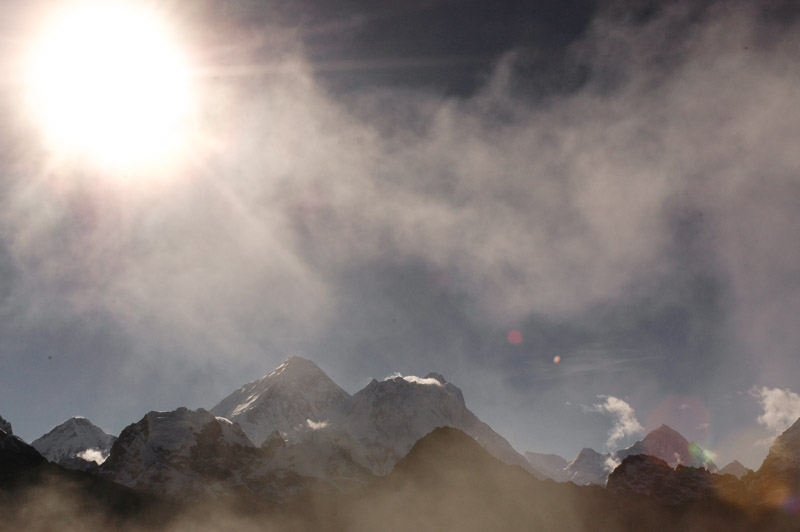
Everest (8850 m), Lhotse (8516 m), Makalu (8481 m), Sagamartha Zone, Nepal
Dominating the scene of course, is the almost pyramidal south-face of Everest (8,850 metres). Just to the right, nearly obscuring the eight-thousand metre South Col from where Everest expeditions make their final push for the summit, is the mass of Nuptse and behind that Lhotse, which at 8,516 metres is the fourth-highest, and a little beyond this another pyramidal mass, of Makalu, the fifth-highest on the planet at 8,463 metres. Just to glimpse these giants feels like a privilege, but to have such a perfectly clear view, and to sit alone on the summit of Gokyo Ri, my own personal mountain-viewing platform, makes all the trek, the rain and misery more than worthwhile. To have the whole view all to one’s self must make the experience rather different from sharing it with dozens of others in the peak season. Far below me to the south, the dirty mass of the Ngozumpa Glacier recedes into a distance where it appears to fall off the edge of the Earth into boiling clouds. Gokyo village sits far below, the multicoloured roofs of the buildings looking like mere specks next to the surreally coloured glacial lakes, and behind this are two six-and-a-half thousand metre peaks, sharp and fin-like, but dwarfed by the giants just to the north. It’s a sublimely beautiful, massively rewarding experience.

Junbesi, Sagamartha Zone, Nepal
I’d decided not to book a return air ticket, and so it will take me ten days to reach the roadhead at Jiri. The descent is long and arduous, continually cloud-wrapped and offers very few views. Passing Lukla with its airport, the villages change markedly; gone are the majority of tourist-oriented teahouses, and one feels to be more in the ‘real’ Nepal. In the eight days from here to Jiri, I would meet just one other foreigner. It’s also a beautiful area, with bucolic highlands of stream-water pouring into wooden troughs, small, subsistence crops of maize, wheat, barley, vegetables and millet and friendly, curious peasant folk. I stay in various homesteads, and the highlight of each day is the lunch and dinner of dal bhat (lentils and rice), a simple, healthy, filling dish which I never tired of. I descend through endless cloudy, terraced hillsides and simple stone-hut villages, until I enter a stunning valley dappled with dark-green patches of pine forest, at the bottom of which lies the gorgeous village of Junbesi. With a jumble of neat, whitewashed houses with colourful roofs and window frames, surrounded by wild-flower filled orchards and backed by dark green hills, Junbesi could almost be a scene from a Bavarian postcard, and is one of very, very few places in the Indian Subcontinent which has been made to look pretty, and kept so; a tiny Nepali Shangri-La. In the next village of Tragdobuk, I stay for a night with a wonderful Sherpa family. The mother of the family is away in Kathmandu, and the father, Dorjee Sherpa, is busy reaping the last of the season’s barley which is stacked into every room of the house bar mine, in light of the ever-increasing monsoon. In the evening, he cooks an especially filling dal bhat accompanied by maize chhaang, which has a pleasant, beer-like tang over a thick, filling corn base.

Sherpa Girl, Tragdobuk, Sagamartha Zone, Nepal
Despite these occasional perks, the long days of trudging up and down slippery, damp paths, avoiding leeches which may drop onto one’s body from the plants which line the paths, and with almost no rewarding views, becomes tiresome. I’m still thrilled at having had such a personal experience amongst the world’s highest peaks, but at this stage all that sustains my morale is my well-thumbed copy of Peter Hopkirk’s The Great Game, and the thought of returning to the truck and driving up into the high-altitude deserts and lakes of Ladakh with barely a monsoon cloud in sight. As I approach Jiri, I leave the Sherpa area, and enter slightly larger, predominantly Hindu settlements which are shabby and poverty-stricken, and where every child asks for pens, then money. A day from Jiri, just as the end of my long walk back from Gokyo seems in sight, I meet an American volunteer who gives me a startling piece of news; there is a bus strike in Jiri, and no transport to Kathmandu. I curse myself for not having booked a return flight from Jiri.
Arriving in the nondescript market town of Jiri, my fears are confirmed: no transport is running. The strike is due to the monopoly held on the Kathmandu route by one bus company, representatives of whom have arrived in town for negotiations which seem to be going well. By 17:00 I have a ticket for a bus the following morning; the end of this huge walk seems to be in sight. But in the morning the deal is off, and I’m still in Jiri. Further negotiations are taking place, and I find a place on a pick-up heading to the capital. The driver however, hearing that a police car has been stoned for travelling during the strike, wisely decides against making the journey. Talks don’t seem to be going well, and just after midday an angry mob forms, smashes the windows of five or six buses, guts the bus station office, smashing the wood panelled walls, ripping out furniture and scattering papers through the street. It’s a good example of how easily anger can boil over in the such impoverished communities. I curse the country and its restive population; all I want to do is get out of Nepal.

Overloaded Bus, near Jiri, Janakpur Zone, Nepal
In a mood of resignation early the following morning, I shoulder my backpack once more and begin walking on the road to Kathmandu. For a country of people who are overwhelmingly pedestrian, there are almost no others making the walk along the road. At around midday, after walking eighteen kilometres, I get a lift a short distance to the town of Tribeni, where I get an onward ride in the back of a truck carrying granite slabs and perhaps forty other people. The driver of this vehicle, like many Asian drivers, seems to be subject to a religious injunction to using first gear, or perhaps feels it is an affront to his manliness, and labours the overloaded truck in second gear up steep hills, with the almost immediate result of waves of hot clutch-smell filling the cargo area in the rear, in which we are all sat. Inevitably, after twenty minutes, the truck expires at the roadside, with a steady stream of smoke issuing from the clutch housing. I curse the country again, and the imbecility of the driver, who luckily has a spare on hand, and has one of his boys swap the clutch plate over in surprisingly little time.
It’s around 02:00 when we finally arrive in Kathmandu. I share a taxi with Kedar, a fellow passenger and native of Jiri who is returning to his teaching post in the capital. He invites me to rest for the night in his apartment, and early the next morning I move back to Mario’s place in Handigaon.
Terai Landscape, Lumbini Zone, Nepal
While my return walk was long and unexciting, it has given me a small insight into seeing the ‘real’ Nepal, as it is for much of the country’s population who live in areas devoid of any modern infrastructure. I’ve witnessed the peaceful goings-on of these small peasant communities; tending and harvesting crops, fetching water, winnowing wheat, chasing chickens out of kitchens, just as subsistence life unfolds all across Eurasia. One appreciates the peacefulness of an area devoid of modern machinery; cars, motorbikes, trucks, tractors, generators, televisions, radios and so on. From my point of view, it’s wonderful, for a short time. But at the same time, one is forced to contemplate the backwardness of it all; the poverty, the tough lives of backbreaking labour, the porters who carry loads of up to one hundred kilograms up steep tracks, day after day, the pitiful incomes of people, the lack of sanitation, the malnutrition and, of course the isolation. What does one do out here if something goes wrong? It’s a rare chance in this day and age to see a place which is truly cut-off, well away from all modern infrastructure, even so much as a phone line. It’s a life where, if one wishes to reach the nearest town with its amenities and wider range of goods, one has to walk, perhaps for more than a week. Either walk, or fly, which is a good option in Nepal so long as one can afford the ticket, can get a seat on the aircraft, the aircraft is functioning, the airline hasn’t gone bust, the weather is perfect, no essential air or ground-staff are on strike, and if one’s name doesn’t disappear from the passenger list. It’s a striking degree of backwardness, one which puts even the poverty in Bangladesh, for example, in a new light.

Nepali Man, Bheri Zone, Nepal
I stay for a while in Kathmandu, doing some car maintenance, spending evenings with Liam in a local café, then make my move back out of the mountains, down through the green Himalayan foothills and back to the country’s east-west artery, the Mahendra Highway. In this verdant southerly strip of lowland Nepal, known as the Terai, the monsoon is in full swing, bringing the temperatures down to more bearable levels with torrential deluges of monsoon rain. I stop on the first night in a hotel in the town of Kohalpur, and continue my westward journey the next day. Large, black clouds collide with the foothills, and in one place, where the road is being washed away by a flash-flood, I get chatting to a Nepali motorist who is also waiting for the floodwaters to recede. Deepak, a Hindu poultry farmer who is driving a pick-up full of eggs to Mahendranagar, the last town on the Mahendra Highway, tells me there are more than just natural problems ahead.
Although this lowland area is in comparison slightly more developed than the highlands, it is currently racked by fuel shortages (due to political disputes with India), and a number of local strikes-cum-demonstrations, known as bandhs. Motorists risk having their car destroyed, or worse, by attempting to drive through them, and they frequently bring the country’s few roads to a standstill. Most of them seem to be on the roads heading south into India, which could be problematic as I have insufficient fuel to reach Mahendranagar, but sections of our route seem to be problematic too. I ask Deepak if he knows what the strikes are about. ‘These bandhs; I don’t know what they’re about, and I don’t care. It can be anything. These people are selfish, and they are ignorant. A couple of weeks back, a man in Mahendranagar beat his wife, and there was a strike! It makes no sense, and it doesn’t help anyone.’

Karnali River, Chisapani, Seti Zone, Nepal
I make my way through the floodwaters and manage to find enough diesel to get me into India, buying ten litres in one station, five in another and so on from reluctant station-owners. At Chisapani, the traffic stops once more as there is a bandh fifteen kilometres ahead. Whilst waiting in the receding heat of the late afternoon, I go for a dip in the cool mountain waters of the Karnali River, which flows south to meet the Ganga. It’s a delightful, peaceful spot at the edge of green, hilly jungle. Just before dusk, the traffic starts to move again and it’s a beautiful drive to Mahendranagar on a good, straight and empty road in the soft evening light. As the sun sinks behind huge, bloated cumulus clouds which hover over the plains of India, a palette of magnificent colour spreads across the sky. After all the endless walking in the highlands, it’s wonderful to be back in the car and I’m reminded of how wonderful it is to drive alone on good, empty roads in such beautiful scenery. The further one drives west from capital, the more the country feels like it’s slowly regressing to a simpler pace; virtually all the other traffic on the road is non-motorised; buffalos, goats and bicycles, and some of the locals have taken to the habit of lying on the warm asphalt surface of the highway, making rather alarming obstacles on the now-dark road. It’s a wonderful ending to my stay in Nepal, though I’m glad to be leaving. The country seems deeply troubled, with the grinding poverty and backwardness erupting into anger, civil strife, and occasionally violence. Nevertheless, there is an air of hope among people, and of a hard-earned integration into the country’s political system which I’ve not felt anywhere else in the region. But whatever may lie in the future, Nepal has, for me, set a new benchmark in terms of under-development; my walk of two weeks, something I undertook for pleasure and as a one-off, has given me an insight into the everyday reality of many of the country’s citizens.
I stay a night in a damp hotel in Mahendranagar, and am the first through the border the following morning, having woken up the supine immigration officer on the Nepali side. My sights are now clearly set to the trans-Himalaya; the high, dry plains of Ladakh.
