
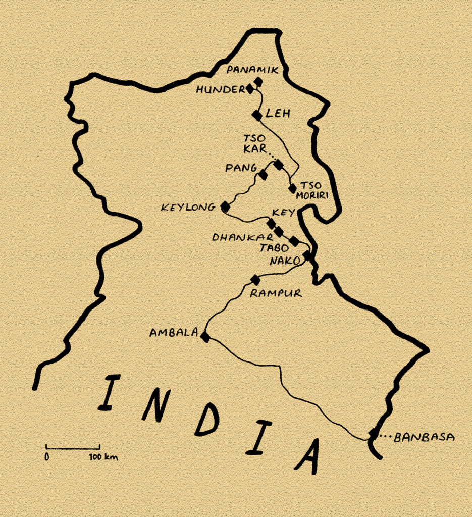
Stage 11 – India: Western Himalaya [1/2]
 The Tibetan Plateau is a huge upland area which lies in the Trans-Himalaya, that is, from a southerly perspective, the area beyond the Himalaya. As the Indian Subcontinent relentlessly ploughs into the rest of Eurasia, giving birth to the Himalaya, this vast plateau has been uniformly uplifted to altitudes of up to five thousand metres. This stark, high and dry region, lying in the rain-shadow of the world’s greatest mountain range, is a land of sublime and other-worldly landscapes; huge open vistas of rolling mountain steppe, fantastically deep-blue skies dotted with ranks of puffy cumulus clouds, and crystal clear high-altitude lakes. Sadly, much of the Tibetan Plateau lies within the boundaries of modern-day China, a country where one cannot move freely with one’s own vehicle. But a small section of it, the former Buddhist kingdom of Ladakh, lies within the boundaries of modern India, and will be the focus of this third visit to the country.

Sutlej Valley, Himachal Pradesh, India
It’s the 17th July 2008 and I’ve just left Nepal to enter India for the third and final time on this journey. I enter the southern reaches of the mountainous state of Uttarakhand during heavy monsoonal rain. Against the deep shades-of-grey sky, the brilliant landscape, shimmering with new fertility brought on by the monsoon, is green-upon-green-upon-green. As I head ever closer to the holy city of Haridwar, huge numbers of trucks occupy the road, slowing down the traffic and muscling past each other with no regard for other road users. In one town, where the traffic stops, a man stands outside my open window, staring in at me blankly like a horror-film zombie. It’s a rude welcome to India after the solitude of the Himalayan trails in Nepal. Darkness falls as I enter the industrial state of Haryana where many of the trucks are heading, and I stop for the night near the town of Ambala. In the morning, I head up once more into the foothills of the Himalaya, to the mountainous state of Himachal Pradesh, passing the hill station of Shimla, crossing the first major ridge and dropping down to the Sutlej Valley.
The road up the valley of the Sutlej, one of the five rivers of the Punjab, is quite a feat of engineering. In many places it has been blasted from a sheer rock face, and winds along the near-vertical valley walls, hundreds of metres above the raging white-water of the river. The road follows the river upstream almost all the way to the Tibetan border, with the valley becoming ever drier and more spectacular as it climbs further from the monsoon-swept plains of lowland India. A few kilometres from the frontier, in a huge brown-grey valley of yawning alluvial hills utterly devoid of vegetation, vastly complex, twisted, tortutred geological strata in the rock exposures attest to a violent recent history. This is the Himalayan suture zone where the Indian Subcontinent met Eurasia roughly fifty million years ago, and continues to do so today. At this point the road turns due north into the Trans-Himalaya, entering the Spiti Valley, through which it will climb to the edge of the Tibetan Plateau.

Dhankar Gompa, Himachal Pradesh, India
As well as marking the tectonic boundary, my entry into the Spiti Valley marks the transition from an area which is culturally Indian, to one which is culturally Tibetan. Buddhist chortens (mound-like structures containing Buddhist relics) start to dot the landscapes, standing out brilliant white in the intense sunshine, against the intrinsic dusty-grey of the bleak surrounding hillsides. In the village of Nako, which sits around a deep-blue lake on a green ledge high above the canyon of the Spiti River, I meet a number of other overlanders; Slovenians Matjaz and Ana in a 4×4, Christoph, a Swiss motorcyclist, Germans Kari and Werner in a 4×4 Unimog camper conversion (which was too large to progress any further up the road, and who I would meet again in Pakistan the following year), and a German cyclist, Christopher. The five of us travel together for a few days up the valley, which becomes ever more beautiful. We Camp together each evening, cooking communal meals, and enjoying the freedom our vehicles give us in this magnificently remote extremity of India.
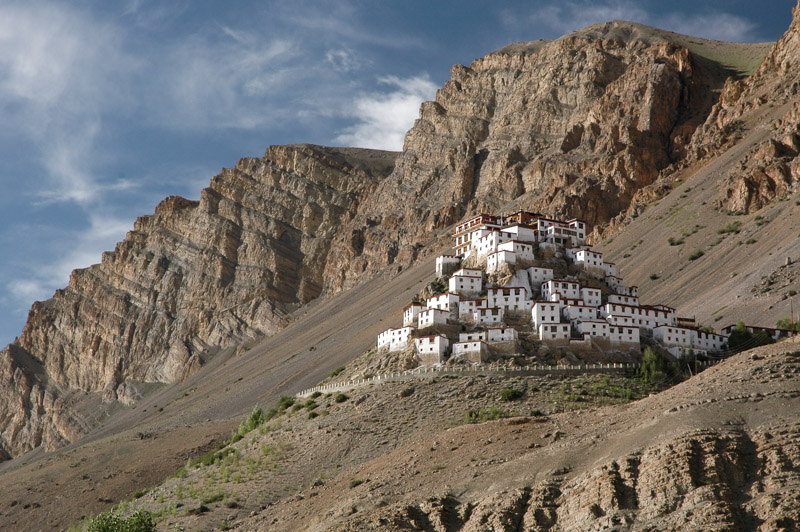
Key Gompa, Himachal Pradesh, India
Like many of the inhabited areas of the Tibetan Plateau, hidden away from the outside world throughout much of history, the immense, forbidding mountains of Spiti are dotted with gompas, Tibetan monasteries of the Mahayana School of Buddhism, which are an almost intrinsic part of the Trans-Himalayan landscape. Tabo Gompa, the largest of the Spiti Valley, will be the retirement place of the Dalai Lama, should he choose to retire from his public activities. The nearby 12th century Dhankar Gompa, the next in the valley, is a fantastic mixture of nature and architecture where the dozen or so religious buildings, brilliant white with crimson roofs and window-frames, nestle like eagles’ nests amongst bizarre finger-like protrusions of soft tuff which hover over the yawning valley. In these fantasy-like settings, generations of monks have devoted their lives to the teachings of the Buddha, renouncing the ways of the world in a hermetic life which seems to compliment the natural austerity of the region, far from the seething crowds of India.
The eleventh century gompa at Key however, is perhaps the most spectacular in Spiti. Dozens of boxy whitewashed temples and meditation cells surround a central monastery, all spread around the conical slopes of a rocky outcrop hanging at almost four thousand metres on the valley-side. Key is an incredible sight, surely one of the world’s most striking architectural complexes.

Changpa Nomad, More Plains, Jammu & Kashmir, India
Next day, Matjaz, Ana and I say goodbye to cyclist Christopher (who will not be able to match our pace), and motorcyclist Christoph (whose pace we will not be able to match), and begin our journey west and then north into Ladakh proper. Crossing the rough, 4,500-metre Kunzun La (pass), we drop down into the district of Lahaul, which is immediately greener, more populated, and less attractive. We make slow but steady progress on the ever-deteriorating roads, first over the 4,900-metre Baralocha La, then into the state of Jammu & Kashmir, winding the cars up to just over five kilometres above sea-level on the endless climb of the Lachalung La. At these altitudes, higher than the summit of any peak in the Alps, the car struggles in the airless altitude, and any significant incline reduces progress to first of second gear. This is the infamous Manali to Leh Highway, built in the 1950’s and allowing surface access to Ladakh from July to October. Although its existence is strategic; due to the need for supplies to be taken up to the frontline of India’s tense standoff with Pakistan and China in the upper reaches of Kashmir, since the 1970s it has been open to foreign travellers, and now sees a steady stream of tourists.
Shortly after the military garrison of Pang, we reach the wide open More Plains, a dusty, desolate flatland which sits between the encircling ranges of mountains. We have reached the Tibetan Plateau proper, the eastern reaches of the huge Changtang which stretches sixteen hundred kilometres, deep into Tibet. Incredibly, out here in this most desolate and rarefied environment, we meet two Changpa nomads herding a surprising number of sheep and goats on foot. One of them asks me for some water, giving me a chance to study him; a stocky Mongol with skin darkened from such high-altitude exposure, his face and lifestyle hark back to the days of Chinggis Khan and the great Mongol hordes.

Wild Ass, Tso Kar, Jammu & Kashmir, India
On these windswept More Plains, a set of dusty tracks head east from the main road to a broad basin, at the centre of which lies the turquoise lake Tso Kar, ringed by soda pans and coarse, brackish grassland on which the three of us camp. To the south are the smooth, undulating ridges of the Zanskar Mountains, whose six thousand-metre peaks look from our elevated perspective to be mere hills. Despite the thin atmosphere, blinding soda pans and fetid, brackish water, the area is far from sterile. The lush grass, though sparse, spreads in a rich green carpet to the foot of the mountains. From the dusty, desiccated earth, marmots dig their burrows, watching us carefully on their hind legs, their front paws held passive on their bellies, with faces like giant guinea pigs. From the grass, early in the morning, larks rise high and unseen into the sky, and the calls of numerous wildfowl on the lake are the only sounds to pierce the stark, deafening silence. In the far distance a kiang, a Tibetan wild ass, its body a two-tone of brown and cream and with a noticeably larger head than a domestic ass, makes his way down to the water’s edge. It’s a sublimely beautiful environment; starkly beautiful, yet benign and comfortable at the same time. These high grasslands, so quintessential of the rolling upland plateaus of inner Asia, are almost certainly my favourite environment. Camping here with friends, totally independent with our cars, is one of the greatest of life’s pleasures. The three of us camp in such a manner day after day, cooking breakfast and dinner in the lee between our cars, sitting out drinking coffee in the most magnificent of landscapes. The sense of independence and isolation is fantastic, and the outside world seems to slowly pull away from our minds.
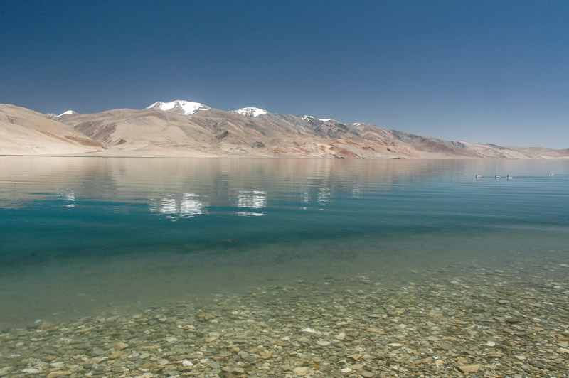
Tso Moriri, Jammu & Kashmir, India
We spend two nights at Tso Kar, before pushing further east into the wilds, passing the tents of more Changpa nomads, who may very well be the strongest-smelling people I’ve encountered. We cross another pass, passing the magnificent Tazang Tso, pushing on to mirror-like Tso Moriri, where we strike another idyllic lakeside camp, watching jeep-loads of tourists who stop a few hundred metres from us for a compulsory two-minute photo stop, before heading on to the rather squalid lakeside settlement of Korzok. North of here, we descend through a purple-rock canyon to reach a river very dear to my heart: the Indus. Freshly arrived from its Tibetan headwaters, the river is small and milky from glacial inputs, and altogether different from the muddy, slow moving giant which I last saw in Sindh, five months ago.
We re-join the main Manali – Leh highway in Upshi, a squalid truckstop set among vast barracks of the Indian Army which mar the landscape for several kilometres, and move north to the Ladakhi capital of Leh. The road passes through villages of unrendered mud-brick walls, behind which are rows of elegant poplars now releasing their cotton in great blizzards, irrigation canals and clouds of tangy woodsmoke. My thoughts are immediately moved to think of Central Asia; of the backstreets of Samarkand or Kashgar and the ancient trade routes which crisscrossed high Asia. Shortly after, we pass on our right Thikse Gompa, the largest in Ladakh, which like a scaled-down Potala Palace transports the mind to Tibet. Despite its marvelous isolation, Ladakh is very much a crossroads of cultures.
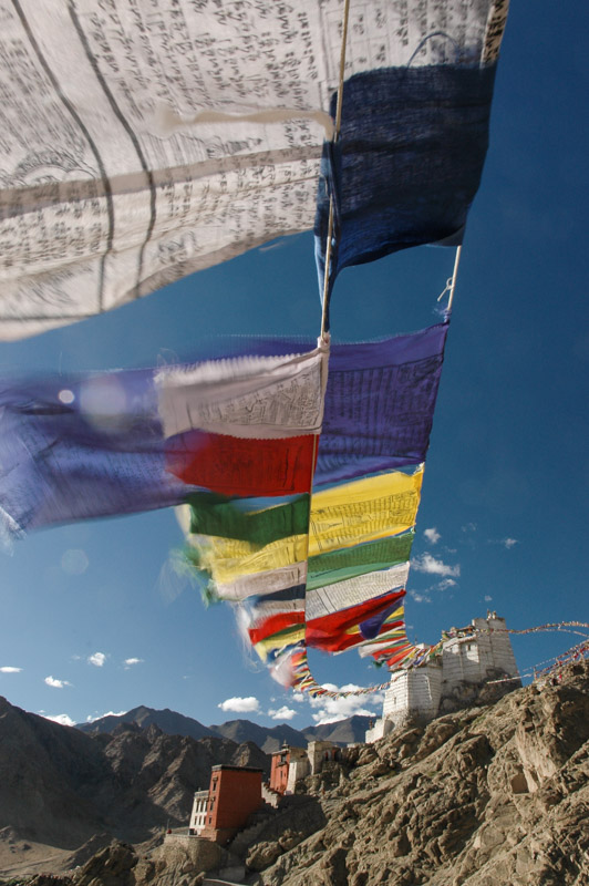
Prayer Flags, Leh, Jammu & Kashmir, India
Leh, the capital of the former Himalayan Kingdom has historically been a crossroads on trade routes which linked India, Central Asia, and Tibet. Today it remains a curious mix of these three Asian cultures, which comes as something as a surprise given its considerable isolation; a city inaccessible by any means other than air from November to June. The native Ladakhis look to be straight out of the mountains of Tibet, though they seem to be outnumbered in the city by Kashmiris from the southeast, who bring to the city a palpable Muslim presence; black beards and white topis (hats), and the sound of the azan (call to prayer), which competes with the chants which emanate from the city’s temples and monasteries. Sikhs, mostly shopkeepers and lorry drivers, wearing colourful turbans add to the kaleidoscope of humanity one sees here. Both these groups can trace their origins in Leh to the annexation of Ladakh by Kashmir in the mid 19th Century, though what draws many to the city, a city which practically shuts-down in winter, are the tourists who make up a considerable proportion of the town’s summertime inhabitants.
Leh seems to attract particular types of tourist; those that favour baggy orange trousers, though there are also plenty of middle-aged European tour groups, and Israelis, who zoom around town on hired or purchased Enfield motorcycles. Indeed, the low, single-cylinder throbbing of these archaic British motorcycles seems as much a part of the aural ambience of Leh as the sounds of Buddhist mantras wafting from tourist restaurants and the afterburners of the Indian Air Force’s MiGs and Sukhois which scream overhead from the airstrip on the town’s outskirts. Yet despite all the tourists, trekking shops, curio stalls, kerbside cobblers, German bakeries, rooftop pizza restaurants, motorcycle hire outfits, Bihari beggars, alternative medicine clinics, massage parlours, drum salesmen and bookshops, the town’s relaxed Buddhist-cum-Muslim atmosphere is decidedly hassle-free when compared to India’s other backpacker hubs. However, with the prospect of more wilderness camping, Leh is little more than a rest and refuelling stop before we alter our border permits with a pen and resume our journey north.
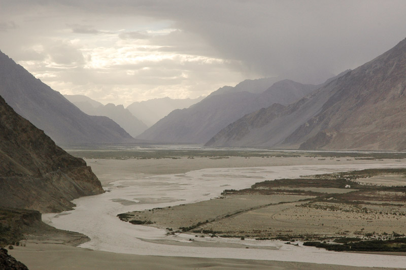
Shyok Valley, Jammu & Kashmir, India
Due north of Leh, a road winds across the Ladakh Mountains, over a low defile known as Khardung La, which at 5,360 metres is the highest road I have driven on (the Indians falsely advertise it as the highest road in the world), a fantastic altitude which is just twenty metres lower than the mountain I climbed in Nepal in order to view Everest. Groups of unfortunate Bihari road-workers in the employ of the Border Roads Organisation fight a losing battle against the streams of meltwater which cascade endlessly down the unsurfaced upper reaches of the pass, from where the view is rather an anticlimax. North of the pass, the road descends through dramatically eroded lunar mountains dotted with villages of brilliant green barley fields, to the Shyok Valley. On our way down, we are held up by the Indian Army, who, through astounding incompetence have managed to get two of their trucks travelling in opposite directions wedged on a sharp mountain bend, high above the Shyok Valley. As the two officers argue over who is to blame, and who should move first, one wonders how such fools could ever conduct a military campaign. It’s also a reminder that this is a highly sensitive military area, bounded by long-disputed borders with two nuclear superpowers, with both of whom India has engaged in armed conflict. Following the Shyok River downstream to the west would lead one to the Line of Control, the hotly contested cease-fire line with Pakistan, while to the north the Nubra Valley leads to the world’s highest battleground, the Siachen Glacier, and the Shyok Valley leads upstream to the disputed border with the Chinese-occupied area of Aksai Chin, where India fought a war in 1962. To date none of these borders have been ratified, with India making territorial claims in all directions.
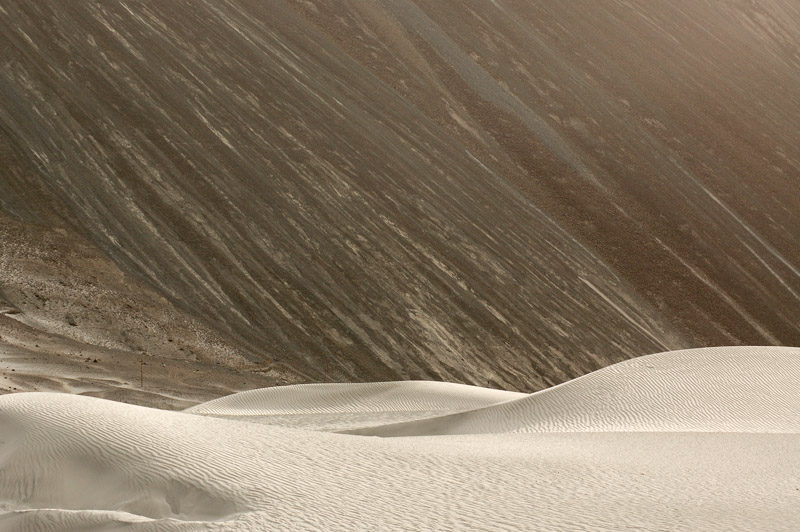
Sand Dunes, Hunder, Jammu & Kashmir, India
Having passed the blithering Indian Army, we descend to an environment quite different from the Chagtang of Ladakh. We camp overnight in an apricot orchard in the village of Diskit, before moving as far east as is possible for foreigners, the village of Hunder. Hunder is a sprawling village of apricot orchards, clear river-water running in irrigation channels, and dry stone walls topped by thorny bushes which grow in the gravely alluvial deposits, all of which make it far more reminiscent of the Wakhan Valley in Tajikistan or Pakistan’s Hunza Valley than the sere landscapes of Ladakh. Beyond the village, the broad river valley where the Nubra River joins the Shyok is filled with fluvial sand, which has been whipped into smooth, sensual dunes by strong winds which come from Tibet in the east. We camp in amongst these dunes, a strange mini-desert within the stark mountains, near a group of Czech tourists, whom we befriend. In the company of my Slovenian travel-partners, and the group of four Czechs who sit around a campfire playing music and singing, I’m reminded up here in the austerity of the high Himalaya of the great warmth of the Slavic soul, and I appreciate more than ever the sense of absolute freedom in this fantastic landscape.

nice report and brilliant pictures, buttmunch! Took me a few years to find… 🙂 I’m still glad we’ve met and spent those happy days together. Please be aware that “… Christoph, an Austrian motorcyclist…” is a real Swiss. 🙂
Mistake corrected, fartnocker.