
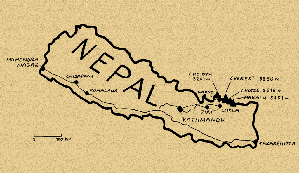
Stage 10 – India & Nepal: Central Himalaya [2/2]
 The fabled mountain kingdom of Nepal is a country in transition; In 2006 the Maoists, who had led a decade-long communist insurgency were formally integrated into the Nepali Government. Less than two weeks before my arrival, King Gyanendra was constitutionally forced to abdicate thus transforming Nepal into a republic. On my third day in the country, the former king, a man accused of widespread embezzlement, makes an emotional plea to the impoverished populace of this backward Himalayan state and vacates his huge, opulent Narayanhiti Palace in the capital. None of this would impact my plans in Nepal; which were to trek up amongst the highest peaks on the planet. Here, amidst long-awaited glimpses of the lofty Himalaya beyond the broiling monsoonal clouds, I would see a country still barely touched by modernity, passing through villages disconnected from any modern infrastructure whatsoever. It would be an uplifting and eye-opening trip beyond the frantic roads and cities of the subcontinent.
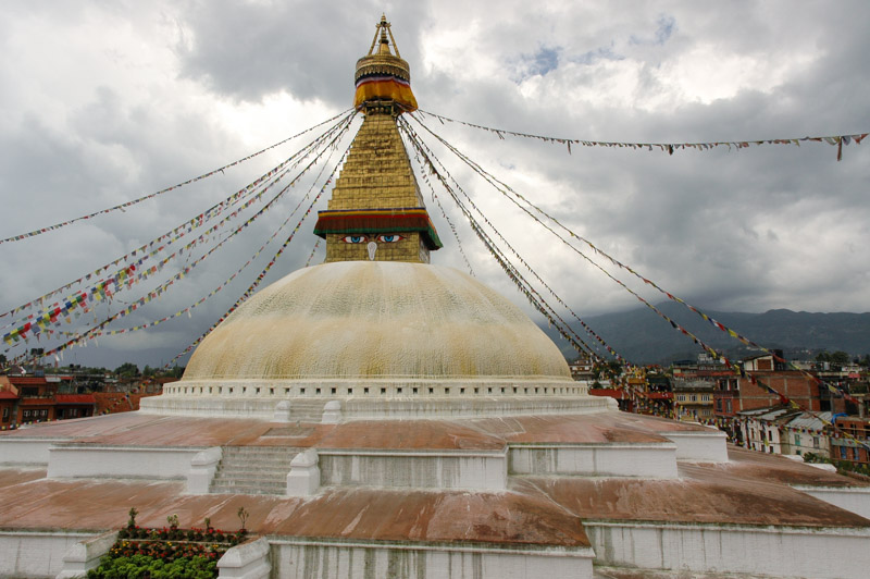
Bodh Nath Stupa, Kathmandu, Bagmati Zone, Nepal
In the morning of the 28th May 2008, I cross into Nepal at its easternmost point and drive directly up into the foothills, reaching the capital well after dark. Kathmandu, as the capital of a famously beautiful and exotic country, is rather a mundane place, though not unpleasant. It’s less squalid than most of the subcontinent’s major cities, with a free-market air, and a noticeable presence of many western aid and development organisations. The city is surrounded by a backdrop of rolling green hills and distant snowpeaks, now almost permanently obscured by the haze and clouds of the monsoon. There’s a noticeable air of religious tolerance here, and indeed the country itself is a land where Hinduism and Buddhism sit easily side-by-side. The city’s most iconic building is the 8th century Boudhanath Stupa, painted with the all-seeing eyes of the Buddha and festooned with prayer flags. Across the city in Durbar Square are a collection of ancient Hindu temples dedicated to various deities, including a striking idol of the Hindu deity Kali, goddess of power and consort of Shiva. Here the air is alive with incense among distinctive Nepali architecture; red-brick temples with multi-tiered timber roofs.
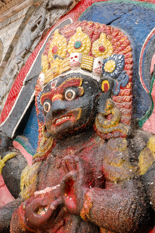
Kali Idol, Kathmandu, Bagmati Zone, Nepal
But it is the people of Kathmandu who are in my opinion, its greatest attraction. Unfalteringly friendly and welcoming, despite the concentration of tourists, and are an attractive mix of the two great swathes of humanity which meet in the Himalaya; Indo-Aryan face from the south, blending into lighter-skinned, round-faced Nepalis, to Tibetans with their high cheekbones and pink-tinged cheeks. There’s little of the usual hassle of India, no crowds of vacant starers, and even the beggars, who seem all to be dark-skinned Biharis, the archetypal beggars of the subcontinent (I never saw a Nepali or Tibetan begging) are gentler than in India.
The city draws huge numbers of tourists, and has done so since the Asian overland trails started in the 1960’s, who flock to the central district of Thamel, a veritable tourist ghetto set along ‘Freak Street’. Thankfully, I’ve found accommodation with an American volunteer, Mario, in the largely foreigner-free district of Handigaon. It’s in a shop here that by chance I meet Liam, a Welsh ex-pat who runs a UK internet cosmetics business from his Handigaon flat. Over plates of buff (buffalo) chow mien, and cans of Nepali-made San Miguel lager, he tells me a story which exemplifies the anger people feel towards their decadent former royal family, and a story which is sadly not unusual amongst the rich-and-powerful of South Asia. One of the King’s sons was in a nightclub owned by a friend of his. He noticed someone had written something on his car, and, fetching a shotgun from the car boot, shot wildly in one of the club’s bars, sped off in his car (drunk), killing a Nepali actress. He was duly arrested and detained, but the following day released without charge. Similar stories abound of Indian film stars, and Pakistani landowners.
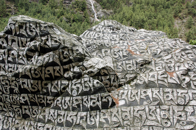
Tibetan Carvings, Phakding, Sagamartha Zone, Nepal
My reason for coming to Nepal however is to see more of the world’s tallest mountains, far to the north in the district of Solu Khumbu, or simply the ‘Everest Region’. One very noticeable aspect of Nepal having not been part of colonial British India is a glaring lack of infrastructure. Everest is almost two weeks’ walk from the very last town accessible by road, and so I decide to save around ten days of walking by flying from Kathmandu to the airstrip in the Sherpa village of Lukla. Kathmandu’s domestic airport has the air of a bus station, with frequent arrivals and departures of small propeller aircraft, which are the only means other than walking, of reaching many parts of the country. After an interminable wait, and thirty minutes after what was meant to be the cut-off time, my flight is called and I board the small Dornier turboprop aircraft. There are fifteen passengers aboard, of whom three are foreigners, and one very attractive stewardess who hands out small wads of cotton wool for the purpose of plugging ones ears against the drone of the propellers, and small toffees. She takes the pilot a Snickers bar and something wrapped in an air-sickness bag, presumably not vomit. We fly just above the boiling froth of monsoon clouds, only once glimpsing a distant peak to the north very briefly. Once again I hope that the clouds won’t prevent me from seeing the mountains throughout the trip. The landing at Lukla is memorable; the aircraft lands heavily at the bottom of a steeply inclined asphalt airstrip (one wonders how the asphalt was brought here), which hovers above an abyssal valley. At the top of the airstrip, it seems the aircraft will crash straight into the mountainside, but swerves at the last moment sharply to the right and comes to a stop neatly outside the stone-walled terminal building.

Gokyo Valley, Sagamartha Zone, Nepal
Nepal is in many way’s the world’s best country in which to trek. In a country where perhaps 50% of the population must walk a day or more from the nearest roadhead to reach their homes, the country’s well-worn mountain trails are lined with facilities which preclude the necessity for guides, porters, cooks, pack animals, tents, cooking facilities, and even food. This makes trekking here extremely affordable and accessible, though of course this draws vast numbers of foreign trekkers, who swarm certain routes transforming these service trails into tourist trails. By coming in the monsoon season however, one escapes the choking crowds, and can have a totally different experience of the mountains. The drawback of course, is catching only fleeting glimpses of the mountain grandeur which lies behind the banks of swirling cloud. Once again, the undertaking is a gamble; risking missing the views in return for missing the crowds. As I enter Sagamartha (the Nepali name of Everest) National Park, I notice a visitor logbook. Last October (the peak season), the gate counted 7,750 foreign visitors, whereas one year ago, in the month of June, just 284. Further to this, I’ll be heading up the less-visited Gokyo Valley rather than heading straight to Everest Base Camp (where one cannot see the summit of the mountain anyhow).

Yak, Gokyo Valley, Sagamartha Zone, Nepal
I make the ascent from Lukla to the trail-end at Gokyo in a leisurely six days, ensuring that I acclimatise sufficiently to climb the final peak, well above five thousand metres, from where I hope to see four ‘eight-thousanders’ including Everest. I have a rest-day in the damp Sherpa town of Namche, the ‘capital’ of Solu-Khumbu, and a town where, at a distance of at least seven days’ walk from the roadhead, almost everything is brought on the back of the local Sherpas who can be seen slowly ascending the steep, rocky trails carrying loads which often exceed them in terms of sheer size, and almost always in terms of weight. I meet one diminutive Sherpa whom I estimate to weigh around fifty-five to sixty kilograms, who is carrying ninety kilograms of bottled lager on his back, in a load which towers above him. The landscape is quite similar to that in Sikkim, though less attractive without the huge rhododendron forests. The area is far more heavily settled, with extensive terraced farming and occasional grazing yaks. Traditional stone-walled dwellings are mixed with more modern ‘teahouses’, which serve as hotels and restaurants to trekkers, and at present are almost all empty.

Ngozumpa Glacier and Gokyo Lakes, Sagamartha Zone, Nepal
The last, steep stage to Gokyo passes the terminal moraine of the Ngozumpa Glacier, the largest in the Himalaya, where a violent tongue of milky brown water cascades from the tongue of dirty-brown rock-strewn ice which creeps incessantly down from the bases of the world’s largest mountains. Gokyo, which lies at 4,770 metres, is one of the very highest settlements in the world and is sustained by the trekking industry. To my relief, I find an operating guesthouse, and check in. The village lies squeezed between the turquoise waters of a glacial lake, and the right-lateral moraine of the Ngozumpa Glacier. Scaling this tongue of glacial rubble on a clear morning, one can look all the way up the grey conveyor-belt of ice and rock to view a wall of glaciated rock which marks the Tibetan border and is crowned by the 8,201-metre peak of Cho Oyu, the world’s sixth highest mountain. The real aim of being in Gokyo however, is to ascend a ridge just beyond the village to a small peak known as Gokyo Ri, which at 5,383 metres provides a spectacular viewing platform towards Everest. One must start the ascent at around 02:00 in order to catch dawn from the summit, and on my first morning, I am just beaten by the clouds which swirl in front of the highest peaks, largely obscuring them. On the second morning, the sky is wrapped in cloud, and I stay in bed. The third morning, initially obscured, clears just before dawn, and I make a belated half-ascent, only to be beaten by the clouds halfway up (and meet a smarmy Frenchman who had perfect views from the summit). It is not until the fourth morning of staying in this rarefied village which lies at an altitude very close to that of the summit of Mont Blanc, that I manage to reach the summit of Gokyo Ri and observe the day begin behind three of the five highest mountains on the planet.
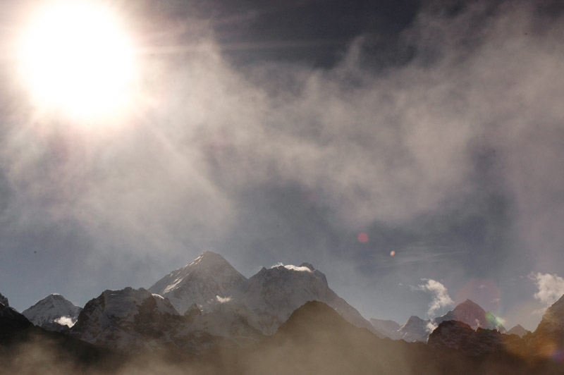
Everest (8850 m), Lhotse (8516 m), Makalu (8481 m), Sagamartha Zone, Nepal
Dominating the scene of course, is the almost pyramidal south-face of Everest (8,850 metres). Just to the right, nearly obscuring the eight-thousand metre South Col from where Everest expeditions make their final push for the summit, is the mass of Nuptse and behind that Lhotse, which at 8,516 metres is the fourth-highest, and a little beyond this another pyramidal mass, of Makalu, the fifth-highest on the planet at 8,463 metres. Just to glimpse these giants feels like a privilege, but to have such a perfectly clear view, and to sit alone on the summit of Gokyo Ri, my own personal mountain-viewing platform, makes all the trek, the rain and misery more than worthwhile. To have the whole view all to one’s self must make the experience rather different from sharing it with dozens of others in the peak season. Far below me to the south, the dirty mass of the Ngozumpa Glacier recedes into a distance where it appears to fall off the edge of the Earth into boiling clouds. Gokyo village sits far below, the multicoloured roofs of the buildings looking like mere specks next to the surreally coloured glacial lakes, and behind this are two six-and-a-half thousand metre peaks, sharp and fin-like, but dwarfed by the giants just to the north. It’s a sublimely beautiful, massively rewarding experience.

Junbesi, Sagamartha Zone, Nepal
I’d decided not to book a return air ticket, and so it will take me ten days to reach the roadhead at Jiri. The descent is long and arduous, continually cloud-wrapped and offers very few views. Passing Lukla with its airport, the villages change markedly; gone are the majority of tourist-oriented teahouses, and one feels to be more in the ‘real’ Nepal. In the eight days from here to Jiri, I would meet just one other foreigner. It’s also a beautiful area, with bucolic highlands of stream-water pouring into wooden troughs, small, subsistence crops of maize, wheat, barley, vegetables and millet and friendly, curious peasant folk. I stay in various homesteads, and the highlight of each day is the lunch and dinner of dal bhat (lentils and rice), a simple, healthy, filling dish which I never tired of. I descend through endless cloudy, terraced hillsides and simple stone-hut villages, until I enter a stunning valley dappled with dark-green patches of pine forest, at the bottom of which lies the gorgeous village of Junbesi. With a jumble of neat, whitewashed houses with colourful roofs and window frames, surrounded by wild-flower filled orchards and backed by dark green hills, Junbesi could almost be a scene from a Bavarian postcard, and is one of very, very few places in the Indian Subcontinent which has been made to look pretty, and kept so; a tiny Nepali Shangri-La. In the next village of Tragdobuk, I stay for a night with a wonderful Sherpa family. The mother of the family is away in Kathmandu, and the father, Dorjee Sherpa, is busy reaping the last of the season’s barley which is stacked into every room of the house bar mine, in light of the ever-increasing monsoon. In the evening, he cooks an especially filling dal bhat accompanied by maize chhaang, which has a pleasant, beer-like tang over a thick, filling corn base.

Sherpa Girl, Tragdobuk, Sagamartha Zone, Nepal
Despite these occasional perks, the long days of trudging up and down slippery, damp paths, avoiding leeches which may drop onto one’s body from the plants which line the paths, and with almost no rewarding views, becomes tiresome. I’m still thrilled at having had such a personal experience amongst the world’s highest peaks, but at this stage all that sustains my morale is my well-thumbed copy of Peter Hopkirk’s The Great Game, and the thought of returning to the truck and driving up into the high-altitude deserts and lakes of Ladakh with barely a monsoon cloud in sight. As I approach Jiri, I leave the Sherpa area, and enter slightly larger, predominantly Hindu settlements which are shabby and poverty-stricken, and where every child asks for pens, then money. A day from Jiri, just as the end of my long walk back from Gokyo seems in sight, I meet an American volunteer who gives me a startling piece of news; there is a bus strike in Jiri, and no transport to Kathmandu. I curse myself for not having booked a return flight from Jiri.
Arriving in the nondescript market town of Jiri, my fears are confirmed: no transport is running. The strike is due to the monopoly held on the Kathmandu route by one bus company, representatives of whom have arrived in town for negotiations which seem to be going well. By 17:00 I have a ticket for a bus the following morning; the end of this huge walk seems to be in sight. But in the morning the deal is off, and I’m still in Jiri. Further negotiations are taking place, and I find a place on a pick-up heading to the capital. The driver however, hearing that a police car has been stoned for travelling during the strike, wisely decides against making the journey. Talks don’t seem to be going well, and just after midday an angry mob forms, smashes the windows of five or six buses, guts the bus station office, smashing the wood panelled walls, ripping out furniture and scattering papers through the street. It’s a good example of how easily anger can boil over in the such impoverished communities. I curse the country and its restive population; all I want to do is get out of Nepal.

Overloaded Bus, near Jiri, Janakpur Zone, Nepal
In a mood of resignation early the following morning, I shoulder my backpack once more and begin walking on the road to Kathmandu. For a country of people who are overwhelmingly pedestrian, there are almost no others making the walk along the road. At around midday, after walking eighteen kilometres, I get a lift a short distance to the town of Tribeni, where I get an onward ride in the back of a truck carrying granite slabs and perhaps forty other people. The driver of this vehicle, like many Asian drivers, seems to be subject to a religious injunction to using first gear, or perhaps feels it is an affront to his manliness, and labours the overloaded truck in second gear up steep hills, with the almost immediate result of waves of hot clutch-smell filling the cargo area in the rear, in which we are all sat. Inevitably, after twenty minutes, the truck expires at the roadside, with a steady stream of smoke issuing from the clutch housing. I curse the country again, and the imbecility of the driver, who luckily has a spare on hand, and has one of his boys swap the clutch plate over in surprisingly little time.
It’s around 02:00 when we finally arrive in Kathmandu. I share a taxi with Kedar, a fellow passenger and native of Jiri who is returning to his teaching post in the capital. He invites me to rest for the night in his apartment, and early the next morning I move back to Mario’s place in Handigaon.
Terai Landscape, Lumbini Zone, Nepal
While my return walk was long and unexciting, it has given me a small insight into seeing the ‘real’ Nepal, as it is for much of the country’s population who live in areas devoid of any modern infrastructure. I’ve witnessed the peaceful goings-on of these small peasant communities; tending and harvesting crops, fetching water, winnowing wheat, chasing chickens out of kitchens, just as subsistence life unfolds all across Eurasia. One appreciates the peacefulness of an area devoid of modern machinery; cars, motorbikes, trucks, tractors, generators, televisions, radios and so on. From my point of view, it’s wonderful, for a short time. But at the same time, one is forced to contemplate the backwardness of it all; the poverty, the tough lives of backbreaking labour, the porters who carry loads of up to one hundred kilograms up steep tracks, day after day, the pitiful incomes of people, the lack of sanitation, the malnutrition and, of course the isolation. What does one do out here if something goes wrong? It’s a rare chance in this day and age to see a place which is truly cut-off, well away from all modern infrastructure, even so much as a phone line. It’s a life where, if one wishes to reach the nearest town with its amenities and wider range of goods, one has to walk, perhaps for more than a week. Either walk, or fly, which is a good option in Nepal so long as one can afford the ticket, can get a seat on the aircraft, the aircraft is functioning, the airline hasn’t gone bust, the weather is perfect, no essential air or ground-staff are on strike, and if one’s name doesn’t disappear from the passenger list. It’s a striking degree of backwardness, one which puts even the poverty in Bangladesh, for example, in a new light.

Nepali Man, Bheri Zone, Nepal
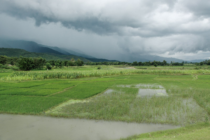
I stay for a while in Kathmandu, doing some car maintenance, spending evenings with Liam in a local café, then make my move back out of the mountains, down through the green Himalayan foothills and back to the country’s east-west artery, the Mahendra Highway. In this verdant southerly strip of lowland Nepal, known as the Terai, the monsoon is in full swing, bringing the temperatures down to more bearable levels with torrential deluges of monsoon rain. I stop on the first night in a hotel in the town of Kohalpur, and continue my westward journey the next day. Large, black clouds collide with the foothills, and in one place, where the road is being washed away by a flash-flood, I get chatting to a Nepali motorist who is also waiting for the floodwaters to recede. Deepak, a Hindu poultry farmer who is driving a pick-up full of eggs to Mahendranagar, the last town on the Mahendra Highway, tells me there are more than just natural problems ahead.
Although this lowland area is in comparison slightly more developed than the highlands, it is currently racked by fuel shortages (due to political disputes with India), and a number of local strikes-cum-demonstrations, known as bandhs. Motorists risk having their car destroyed, or worse, by attempting to drive through them, and they frequently bring the country’s few roads to a standstill. Most of them seem to be on the roads heading south into India, which could be problematic as I have insufficient fuel to reach Mahendranagar, but sections of our route seem to be problematic too. I ask Deepak if he knows what the strikes are about. ‘These bandhs; I don’t know what they’re about, and I don’t care. It can be anything. These people are selfish, and they are ignorant. A couple of weeks back, a man in Mahendranagar beat his wife, and there was a strike! It makes no sense, and it doesn’t help anyone.’

Karnali River, Chisapani, Seti Zone, Nepal
I make my way through the floodwaters and manage to find enough diesel to get me into India, buying ten litres in one station, five in another and so on from reluctant station-owners. At Chisapani, the traffic stops once more as there is a bandh fifteen kilometres ahead. Whilst waiting in the receding heat of the late afternoon, I go for a dip in the cool mountain waters of the Karnali River, which flows south to meet the Ganga. It’s a delightful, peaceful spot at the edge of green, hilly jungle. Just before dusk, the traffic starts to move again and it’s a beautiful drive to Mahendranagar on a good, straight and empty road in the soft evening light. As the sun sinks behind huge, bloated cumulus clouds which hover over the plains of India, a palette of magnificent colour spreads across the sky. After all the endless walking in the highlands, it’s wonderful to be back in the car and I’m reminded of how wonderful it is to drive alone on good, empty roads in such beautiful scenery. The further one drives west from capital, the more the country feels like it’s slowly regressing to a simpler pace; virtually all the other traffic on the road is non-motorised; buffalos, goats and bicycles, and some of the locals have taken to the habit of lying on the warm asphalt surface of the highway, making rather alarming obstacles on the now-dark road. It’s a wonderful ending to my stay in Nepal, though I’m glad to be leaving. The country seems deeply troubled, with the grinding poverty and backwardness erupting into anger, civil strife, and occasionally violence. Nevertheless, there is an air of hope among people, and of a hard-earned integration into the country’s political system which I’ve not felt anywhere else in the region. But whatever may lie in the future, Nepal has, for me, set a new benchmark in terms of under-development; my walk of two weeks, something I undertook for pleasure and as a one-off, has given me an insight into the everyday reality of many of the country’s citizens.
I stay a night in a damp hotel in Mahendranagar, and am the first through the border the following morning, having woken up the supine immigration officer on the Nepali side. My sights are now clearly set to the trans-Himalaya; the high, dry plains of Ladakh.
