
Stage 22 – Russia & Mongolia: Altai To The Gobi Desert [3/3]
It’s the evening of the 12th August 2010 when Jacob and I, driving from Kharkhorin on the only continuously paved road I have encountered since entering Mongolia more than two weeks ago, reach the outskirts of Ulaanbaatar. The suburbs are predictably rather squalid, a mass of chaotic traffic, large areas of seemingly moribund industry, mindless, aggressive drivers and a stench of raw sewage and animal muck. We stop in the pouring rain to have another late lunch, here consisting of buuz (meat-filled dumplings) rather than the dreaded tsuivan (greasy mutton lumps and noodles). The city gradually smartens as the traffic careens headlong towards the centre, and we see used Japanese cars, flashy new SUVs and beat-up Korean saloons instead of the ubiquitous Russian 4x4s of the countryside. We start to pass a succession of shopping malls and seedy karaoke bars advertising ‘VIP Rooms’, eventually finding ourselves in a tidy, smart and superficially modern and very westernised city-centre. By the time we reach our host Elena, a Russian Buryat who lives in a modern high-rise in the centre, the transition we have made today from the pre-modern countryside to the neon lights of the capital seems positively surreal.

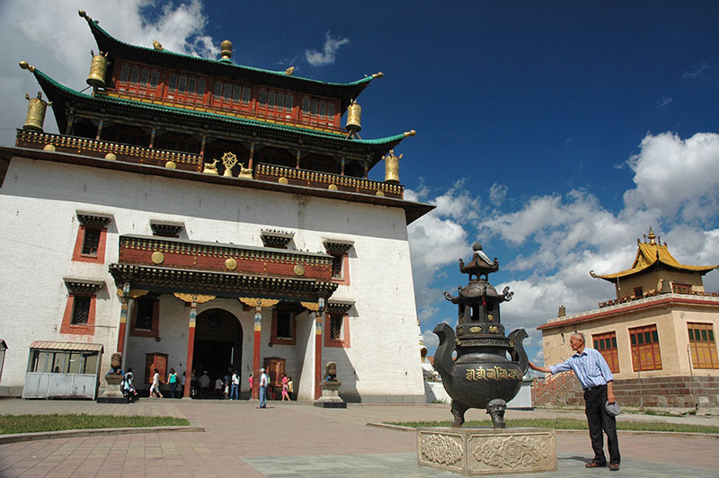
Choijin Lama Temple and Blue Sky Building, Ulaanbaatar, Mongolia
Ulaanbaatar is not an old city, the site having been chosen in 1778 to be the permanent location of a previously nomadic, roaming monastery-city. It was not until the communist era that the city was modernised, and apart from a few temples which survived Stalin’s purge, and the glut of new buildings in the flashy centre, the city is architecturally purely Soviet in style. Indeed, the city’s name, which means ‘red hero’ is clearly of Bolshevik / Soviet origins. Almost half of the Mongolian population of three million live in Ulaanbaatar, with the population ever increasing. This urban drift may have something to do with the country’s recent mining boom, but is largely the result of poverty, exacerbated by harsh winters knows as zuds where thick snow and extreme temperatures devastate livestock and can leave families totally destitute. The previous winter of 2009/10 counted as a zud. Away from the orderly centre, the city is a mess of unplanned building, broken streets and general neglect which reminds me of Kathmandu, and in the farthest western slums one can almost watch the process of urbanisation. Migrants arrive with their gers (yurts), find a patch of land at the city’s edge and set up home, erecting a simple picket fence around their claim. A latrine pit and small outhouse are made, then an electricity hook-up and ultimately a fixed house. Following the slums towards the centre, the gers, unsuited to being continually erected in one spot, slowly vanish, and thus the urbanisation is complete, with nomad turned into city-dweller. Many of these unskilled migrants live in abject poverty and the city has a noticeable underbelly of petty crime, alcoholism and domestic violence.
At the same time however, there is a truly modern, urban Mongolian society, a well-dressed, attractive, educated and sometimes well-moneyed class. While Mongolian society in the countryside is undoubtedly traditional, these are not people who are restricted by the backward mores of a medieval social system, and the urban young of Ulaanbaatar live a life not much different from their contemporaries in Almaty or Moscow, though a world away from their countryside cousins. To me this is more evidence of the great adaptability of Mongolians, and while the urban class owes much to the communist era, there are also clearly parallels with the air of religious tolerance and pragmatic secularity for which the vanished ancient Mongol capital of Karakorum was famed.
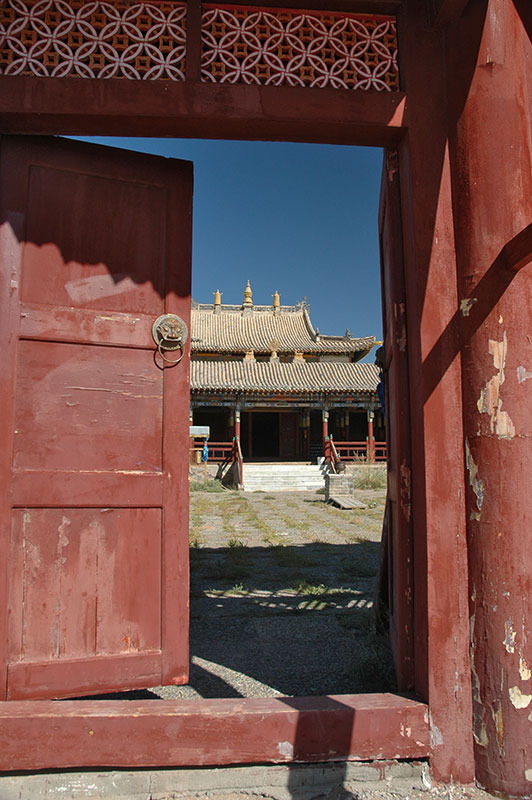
Gandantegchinlen Monastery, Ulaanbaatar, Mongolia
Jacob and I enjoy ourselves in the capital; eating good food, not constantly at the whim of the landscape and elements, and living an easy sedentary life. Ulaanbaatar’s sights are very modest; a few surviving old monasteries such as the large, whitewashed Tibetan-style Gandantegchinlen and otherwise just the Soviet and post-independence monuments and squares, though the National Museum is surprisingly good. One night we visit a rather seedy night club, dancing with very attractive young women but narrowly escaping the violent intentions of young Mongolian men; not the only example of deep-rooted xenophobia in the urban population, in stark contrast to the genuine hospitality of the people we’d encountered on the steppe. I’m also surprised by just how many tourists there are here – in stark contrast to the remote steppe we’ve driven through to get here – and from their accounts of rather superficial encounters with Mongolia on the train between Russia and China, or on contrived jeep-tours, I yearn once more to be free, out on the steppe. I wonder how many of the Mongolian urban migrants soon come to feel the same way after spending time here. After spending a slightly shocking twelve days in this uninteresting and rather unlovable city, Jacob and I depart, aiming for the Gobi Desert.

Ikh Gazriin Chuluu, Dundgovi Province, Mongolia
We leave the sprawl of Ulaanbaatar and head initially south-east, loosely following the Trans-Mongolian Railway which links the Russian city of Ulan-Ude (close to Lake Baikal), with (Chinese) Inner Mongolia and Beijing. Soon after leaving the capital, the low, green-brown hills flatten and after forty kilometres we are on empty steppe. We enjoy an asphalt road for much of the day, and in the late afternoon reach the small town of Choir. Once a Soviet military cantonment, Choir is the capital ‘city’ of its own small province, Govisümber, though is today little more than a large village and a near-deserted station on the Trans-Mongolian. We buy cold beers and ice creams and then head west a few kilometres and camp on the flat steppe. The temperature is pleasant and as the sun sets and a brilliant full moon rises against the day’s small drifting cumulus clouds, we revel once more in the wonderful feeling of freedom we have out on the steppe.
In the morning we continue westwards, aiming in the next few days to skirt the northern fringes of the Gobi Desert before plunging south to the sandy wilderness close to the Chinese border, from where we aim to move steadily eastwards to the easternmost part of Mongolia. While we have left the asphalt road and are back on more familiar dirt-tracks, the land here is flat and usually dry with very little traffic, meaning that our progress is relatively steady. Far more than the rocky west, this is the Mongolia I had imagined before coming here; rolling green plains dotted with yurts and cattle under huge, deep-blue skies with sparse ranks of clouds. Soon enough however, the land changes dramatically as we enter an area of red-basalt outcrops known as Ikh Gazriin Chuluu, a first taster of the Gobi Desert. We scramble around the dramatic, isolated piles of rock for a few hours before stopping for a meal and provisions in the provincial capital Mandalgovi on our way further west.
Gimpil Darjaalan Monastery, Erdenedalai, Dundgovi Province, Mongolia
Our destination the next day is Erdenedalai, a small, nondescript sum (district) centre which would be wholly unremarkable were it not for the beautiful late-eighteenth century Gimpil Darjaalan Monastery. The monastery consists of a single, surprisingly large Manchu-style temple which combines an outer perimeter gallery colonnaded with ornately painted wooden beams, with a large central hall, topped by a very elegant two-tier, meticulously tiled pagoda roof. The monastery somehow escaped Stalin’s purge, serving as a storage area until independence in 1990. Its presence is rather baffling on this otherwise totally featureless plain.
West of Erdenedalai, the landscape becomes drier, subtly more desolate and hostile. We pass some ancient stone-topped kurgans (burial mounds) marked out with a square of perimeter stones, lying totally anonymously in the semi-desert, traces of a long-forgotten culture. We lose the main track and, while Jacob snoozes, I drive through low, almost trackless valleys, past isolated gers and shepherds for several hours before reaching the tiny sum centre of Sant, from where we find a small track due west. Shortly after, we come upon the abandoned settlement of Dolgon, a small, communist-era agro-industrial complex now heavily looted for scrap and building materials. We wander into what must once have been an administrative building, a lone two-storey structure amongst the Mongolian wilderness investigating old office records, rather puzzled as to what the purpose of this factory might have been, and why it is situated away from any town or road.
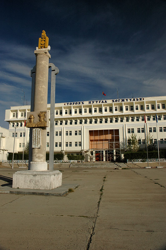
Central Square, Arvaikheer, Övörkhangai Province, Mongolia
Later we come to the Ongi River and have a very welcome bath, then fording the river to join the asphalt of the ‘Southern Route’, Mongolia’s main east-west highway. In the morning we explore Arvaikheer, the capital of Övörkhangai Province which is a little smarter than most Mongolian provincial capitals. Rather than the usual crumbling communist-era concrete, here the provincial administration building has been smartened up and is positively elegant, sat behind a concrete slab-paved square with a stele bearing the Mongolian coat of arms. There is even a patinated bronze sculpture of what I assume to be a miner, though his features are clearly, and rather patronisingly Caucasian.
West of Arvaikheer, the asphalt soon ends and the highway reverts to a heavily wash-boarded dirt track, making for rather unpleasant driving. I’m looking for a decent-sized track heading south which will take us deep into the Gobi Desert. The philosophy of driving and navigating in Mongolia is quite different from anywhere else in Eurasia. Aside from perhaps two highways worthy of the name, there is no single defined route between any two places, and certainly no signposts. Instead, one relies on bearings, finding a set of wheel tracks heading in one’s chosen direction, and following them, switching to others when necessary to maintain an approximate course. This method can be rather trying in the wetter and more mountainous areas of the country, where deep rivers, cliffs or steep mountains may put an end to one’s progress, but out here in the dry, wide-open plains, it becomes a very pleasant way to travel, almost like navigating across an ocean.

Gobi Road, Bayankhongor Province, Mongolia
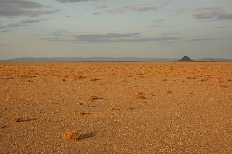
Around one-hundred kilometres from Arvaikheer we leave the Southern Route for good (I break a leaf in the truck’s front-right spring coming down a steep bank too quickly) and proceed south-west, passing Bayanteeg shortly after. Quite quickly the landscape changes again, to the Gobi proper. The Mongolian term gobi literally refers to land which is too poor to support sheep, but on which camels may be grazed. In practice however, the Gobi Desert occupies a vast tract of inner Asia, stretching from here to the Tibetan Plateau and occupying much of northern and western China, encountering a wide range of environments. Beyond Bayanteeg the vistas become huge; we can clearly see Ikh Bogd Mountain on the horizon, despite it being sixty-five kilometres away. Occasional gers can be seen next to dry, ephemeral riverbeds, and we wonder what must draw (or force) people to live in such areas. The land becomes a hard-baked undulating plain, and we course at full speed along a winding gravel track, leaving a huge dust plume in our wake.
In the late afternoon we arrive in the small sum centre of Bogd, and find a very pleasant campsite in the small valley of the Tüin River. Now being late summer, the river, one of many which runs from the north and dissipates into the desert, is more like a warm pond but we join the camels who are (downstream) taking a dip after a long, dusty day. Some local children find us and are delighted when we teach them to line up empty vodka bottles and take aim at them with stones; a hobby which Jacob and I have taken up in order to break up long, monotonous drives and break down some of the innumerable vodka bottles which are ubiquitous in the Mongolian landscape.
Progress the next day is slow as we must navigate around the boggy land adjacent to Orog Lake and then cross Ikh Bogd Mountain in an area with no vehicle tracks. After tracking a gulley to the point where it no longer becomes drivable we have to turn around, but find a local to ask and finally make it up onto the southern ridge of the mountain. Here we drive east a little to Tsagaan Agui (White Cave), whose walls are lined with sometimes very large, glistening multicoloured quartz crystals and gemstones, and which was inhabited by Stone Age humans. Late in the afternoon we make it to the sum centre of Bayanlig which sits on the edge of a vast expanse of flat, utterly featureless desert into which we will drive tomorrow. The highlight of the day however is finding that the local guanz (canteen) has the best buuz we would find in Mongolia, and it is with full stomachs that we find a campsite just outside of town.

Bayangiin Nuruu Petroglyphs, Bayankhongor Province, Mongolia
In the morning, before heading into the true desert, Jacob and I drive on a bearing south-west to a range of low, black hills of desert-varnished basalt rock. Our target is Bayangiin Nuruu, a complex of petroglyphs tucked deep in the ephemerally watered valleys which dissect these dark volcanic stands. As so often happens, we lose the track and just two kilometres from target the truck is in a plain of large stones. Jacob scouts ahead, soon finding the right track and I slowly crawl around a small cliff and over to his position, from where we are soon at the mouth of a small valley. We walk up passing boulders, some with single, crude petroglyphs, wholly unprepared for the amazing prehistoric gallery which we find after half an hour or so; a cliffside of fissured black basalt, with multiple panes of several square metres filled with bright orange petroglyphs. Dated at around 3000 BCE, they are younger than the petroglyph complexes I had earlier seen in the Altai Mountains, but here the concentration in such a small area is overwhelming. There are depictions of wild sheep, aurochs, gazelle, reindeer with elaborate, stylised horns, camels, snakes, asses, large cats and boars. Human hunters are shown with longbows, either mounted on horseback or free-standing, and it is theorised that such petroglyphs are some kind of tribute to the spirits of the animals which were the hunter’s prey. There are fantastical, mythical beasts, and depictions of hunters in congress with women, even one of a male figure in posing in tumescence, suggesting a link with early fertility cults. Such petroglyph sites, almost always found in remote outcrops of volcanic rock always raise the question of whether these places specifically were sacred in some way, or if it was simply that the art of such early cults is only preserved in places such as these.
Khatan Suudal Volcano, Bayankhongor Province, Mongolia
We return to Bayanlig in the afternoon to eat more buuz, then head east into a vast, flat, sandy plain. The sand is not deep and it makes for very pleasant driving, though there are well over one-hundred kilometres of almost trackless desert between us and our next destination, making us somewhat anxious not to lose the track we are following. Soon the tracks start to diverge off into the nothingness, but far ahead we spot the small, extinct black volcano of Khatan Suudal, and reasoning that most people will naturally be drawn to this visually striking feature, we simply drive straight over the desert, disregarding the tracks of others. Such driving gives me a sense of absolute freedom, something simply impossible within the narrow confines of Western Europe, and strikes me as being one of the essences of my endless motivation to travel. We camp at the very bottom of the volcano and are of course totally alone in this glorious desert. We climb the volcano the next morning; I half expect to find some petroglyphs on the summit, but there is only a large slate cairn. However, despite being just one-hundred metres above the desert floor, the view is nonetheless spectacular; below us the truck is but a speck, and alongside a single dusty track, is the only sign of human existence we can see in any direction.
Our next target is known as Khongoryn Els, a small sand-sea in the neighbouring province of Ömnögovi, in the driest but most spectacular region of the Mongolian Gobi. We follow tracks for several hours, crossing flat gravelly plains, sparsely-vegetated sands, red yardangs and desiccated mud-flats dotted with saxaul plants. In the early afternoon however, the track we’ve been following leads to the edge of the els (sand-sea). The truck soon bogs, and after one brief spell of digging it is clear that we need to find another way round. We must make a decision however; either to skirt the els to the north and go straight to the spot we intend to camp in, or to drive around the south, close to some nearby mountains and the small sum centre of Sevrei, then crossing the els at a point where the map indicates a track. We have enough fuel to go by either route, but we might not have enough to return and try an alternative if we find our chosen route impassable.

Bactrian Camels, near Sevrei, Ömnögovi Province, Mongolia
The northern option would be more direct, but the area is totally trackless and may therefore be impassable, making us choose the longer but safer southern route. After a few rather tense and rough kilometres tracking south amidst small dunes, we are relieved to find a track and even see another vehicle; the first since leaving Bayanlig the day before. By late afternoon we’re climbing up a rough wash towards Sevrei, but once again lose the track and end up cutting across tortuous goat paths, reaching the tiny settlement after dark.
In the morning we wish to buy some diesel but the laziness of the fuel station owner exceeds my patience and we descend back to the dunes, letting some air out of the tyres and driving over the sandy edges of the els where beautiful Bactrian camels are nonchalantly grazing in the sparse shrubbery. We find something of a cleft in the els, a narrow, silty wadi which to our amazement is filled with thick, muddy floodwater from recent rain. After walking around on the nearby dunes and confirming that there is no alternative route, we have no option but to wait for the water to recede and the ground to become firm enough to drive over. This only takes a couple of hours however, and with Jacob once again scouting ahead, I carefully drive over the riverbed, which has been eroded into deep gulleys in places, then power through a long section of deep sand until I reach a firm area clear of the far edge of the els, and wait for Jacob to walk over.
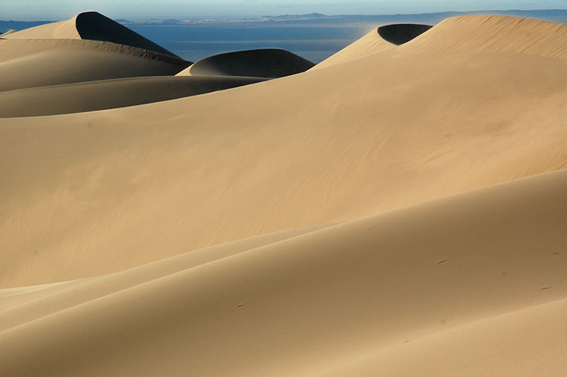
Khongoryn Els, Ömnögovi Province, Mongolia
It’s a joyous moment when we get the truck through; we’re relieved not to have got stuck or worse, and thrilled at having finally almost reached our destination after a particularly strenuous journey from Bayanlig. We’re also noticed by a van full of Mongolian men who stop and of course start drinking vodka, inviting us over to join them. They’re a rough but good-spirited and generous bunch, but after a few bowls we manage to excuse ourselves before things get too wild, and drive south to our camping spot at the foot of Mongolia’s highest dunes, hoping to be far enough from the tourist jeeps and ger camps to have the desert to ourselves. In the late afternoon we haul ourselves up to a high ridge in the els, lying on our backs against the steep slipface of a dune in a rather blissful state. We are sitting atop a beautifully sculpted sea of yellow sand which extends around fifteen kilometres to the north-west, behind which, in the very far distance are black ridges of desert mountains close to the area we passed yesterday. The temperature is perfect, and watching the sun set from here is one of my absolute favourite moments of the trip, one that I will never forget.

Khongoryn Els, Ömnögovi Province, Mongolia
The Gobi Desert is the world’s fifth largest and also one of its coldest, and it is therefore on a warm September morning particularly pleasant to walk among the dunes, in the absence of blazing sun or scorching heat. We spend the whole day at the els, though sadly a storm passes in the afternoon, covering us with wind-blown sand and ruining any chances for another beautiful sunset view of the dunes. On our second and final morning I walk east along the els, reaching a small area of lush green grassland on which happy Bactrians graze below small mountains of golden sand. On my walk back I’m so deep in thought that I overshoot our campsite by more than a kilometre, and finding myself slightly disoriented, only recognise our campsite from the profile of the large dunes which I know to be right behind it.
We continue our journey east, travelling on a good solid track past the els and on to an evening stop near the sum centre of Bayandalay, then passing the following morning close to the ‘Flaming Cliffs’ where American palaeontologist Roy Chapman Andrews famously discovered the first dinosaur eggs in the mid-1920’s alongside many other dinosaur remains, and where of course there are no bones for the casual visitor to see today. We stop in the provincial capital of Dalanzadgad and make use of the bathhouse, guanz, well-stocked shops and fuel station, then press ever further east. Here the land starts to revert to true gobi as the desolate sands and black mountains of the south start to blend into lightly vegetated plains.
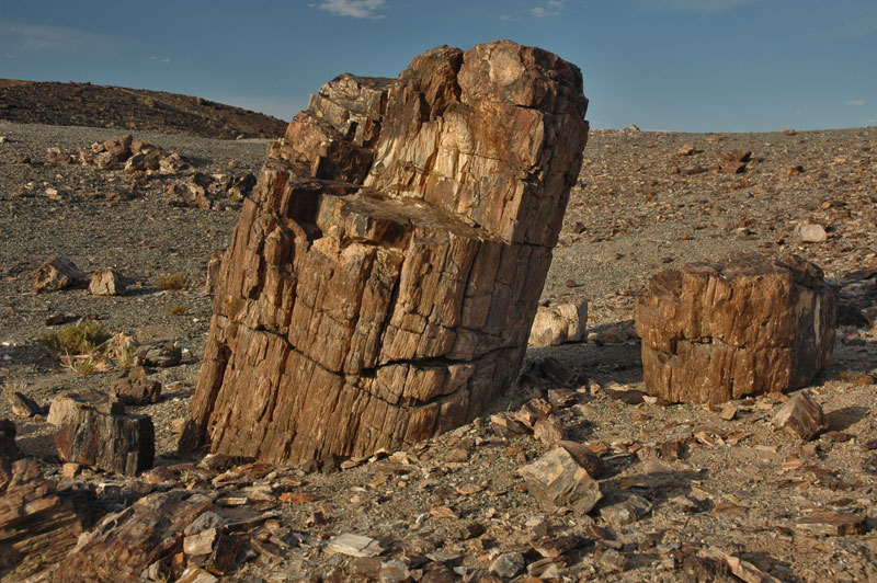
Petrified Tree, Mt Suikhent, Dornogovi Province, Mongolia
The tracks are very sparse and we are relieved to reach the coal-mining town of Tsogttsetseii in the evening, where we camp. Here we see the incredible scale of mining operations in the country; throughout the night we can hear a steady drone of mine machinery and there is an extraordinary, never-ending convoy of trucks carrying coal – at a rate of several trucks per minute – along a dusty desert track, straight to the border crossing with energy-hungry China, around two-hundred kilometres away. We have lunch in a guanz full of noisy Chinese mine engineers in the sum centre of Khanbogd, the nearest town to the huge Oyu Tolgoi Mine. This controversial mine is the largest investment ever made in Mongolia; a joint venture between Rio Tinto and the Mongolia Government, a boon to the Mongolian economy and a potential disaster for the delicate Gobi environment, it’s flora, fauna and water resources. While mining is set to potentially transform the Mongolian economy into one of Asia’s most dynamic, many Mongolians feel understandably resentful towards such projects; spelling and end to the traditional nomadic way of life and a threat to the beautiful, pristine landscape of Mongolia to which they are deeply and spiritually attached.
In the late afternoon we finally leave Ömnögovi Province and reach our target, a small black outcrop of basalt known as Suikhent Mountain. Millions of years ago the area was a boggy forest, and the trees which fell in this bog have been preserved and mineralised into petrified wood; rocks with the original form, texture and internal structure of trees. We camp in a small valley filled with intriguing petrified logs and tree stumps. It’s the warmest evening we’ve yet had and we sit out wearing only shorts, late into the evening drinking tea and savouring the setting, for there is hardly a trace of human presence in the entire area.
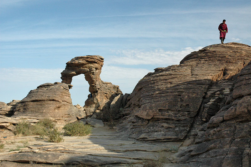
Senjit Rock, Dornogovi Province, Mongolia
It’s a long drive the next day, passing the huge, eerily ruined complex of Ölgii Monastery, then heading north-east through almost totally unpopulated, largely flat territory as we aim for the tracks of the Trans-Mongolian once again. We camp just short of the town of Sainshand and are met shortly after stopping by a pair of curious Mongols who arrive on an ancient Soviet motorcycle. After making a few gestures to each other, our visitors retreat a few steps and calmly watch us for an hour or so as we cook some pasta and make tea, before slipping away into the night. We reach the railway town of Sainshand in the morning, capital of Dornogovi Province, and by evening we are in a large area of odd volcanic outcrops. Darkness and a howling storm close in on us before we can reach our intended camping spot, and it is not until the following morning that we reach the striking and locally famous natural rock arch known as Senjit Rock.
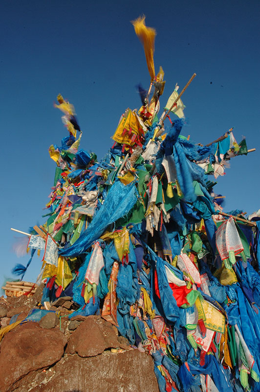
As we continue ever east into Sükhbaatar Province, the landscape changes very slowly as we leave the desert and enter the grasslands of the Mongolian East, passing sum centres such as Delgerekh, Bayandelger and Ongon; places which even by Mongolian standards feel isolated and forlorn, though the people are friendly and welcoming, if extremely surprised to see two outsiders arrive. Turning south-west towards the Chinese border we must employ some subterfuge, for we are in a restricted border zone for which permits are required. Having tried but failed to obtain them in the capital, we instead resolve to avoid settlements and be totally self-reliant in fuel, food and water for the next few days. Our first stop is in the sum of Dariganga, where the extinct volcano known as Altan Ovoo is considered a holy mountain. In a fenced enclosure near the deeply weathered volcano are three Mongol-era balbals (anthropomorphic megaliths), two of which are decapitated. All three are swaddled in long, sky-blue votive cloths, and offerings are made at their bases; sweets, vodka, trinkets such as miniature boots and most bizarrely, a tea set consisting of three porcelain pigs straddling a sugar bowl. Pilgrims leave such offerings here before climbing the mountain and circumambulating its simple white-washed ovoo (shamanistic totem or altar).

Altan Ovoo, Dariganga, Sükhbaatar Province, Mongolia
We spend the evening camping amid small trees on the very edge of Moltsog Els, a small and vegetated sand-sea just to the east of Dariganga. We’re discovered by some locals on horseback, but they soon disappear and we slip away in the morning unnoticed. East of town begins the Dariganga Volcanic Field, consisting of over two-hundred Quaternary lava and cinder cones, a flat area of grassy steppe now yellowed from the long, dry summer and dotted by sculpted volcanic mounds. Entering a very subtle, open valley known as Khurgiin Khundii, we spot an odd, basalt balbal of a gaunt and naked man sitting on a rock, his right hand holding a votive cup, his left on his genitals. Equally striking is the totally unannounced cave of Taliin Agui; rather than a conventional cave in a mountainside, this cave consists of a void-space in a lava flow and is accessed from the table-flat steppe through a small hole in the ground. Despite being late summer, temperatures in the cave remain sub-zero; the cave roof is a sea of white filigree ice crystals, while the floor is dotted with smooth ice-stalagmites.

Dariganga Volcanic Field, Sükhbaatar Province, Mongolia
Our destination for the day is the highest of the volcanic cones; Mt. Shiliin Bogd, a sensual, crescent-shaped eroded cinder cone, long-dormant and covered in long grass. The mountain is just five kilometres from the Chinese border and considered amongst the most sacred in Mongolia. The soul of a man (and only a man; women are not allowed) who walks anti-clockwise around the mountain’s summit (especially at dawn) is said to be restored. We drive part-way up the side of the mountain, where we strike camp and then set off around the crater rim. The view from the top is utterly magnificent; a true moonscape of craters and ridges extending to an indeterminate horizon, particularly beautiful in the low-light of sunset.
In the night we are rather startled by a lone pair of headlights jolting across the steppe, aiming straight for us; we kill our lights and keep a close eye on the approaching vehicle, worried that it might be the local border patrol coming to apprehend us. The vehicle stops some distance away at the foot of the mountain, and we discover in the morning that a group of Mongolian businessmen from the capital have come to on a pilgrimage to the holy mountain to restore themselves spiritually. We walk up together, the Mongolian men (one of whom speaks good English) wearing expensive traditional deels (coats) and offering us a nip from their snuff bottles. At the summit, the men circumambulate around the huge ovoo which is covered in offerings such as sweets, hard bread and alcohol and tied with long blue prayer pennants which are thrashing in the stiff morning breeze. We drink bowls of vodka together and marvel at the sublime view as the rising sun catches the profiles of the long-dead volcanoes. I’m impressed that these men, like me, seem genuinely enchanted by their surroundings, more so that despite being wealthy and urbane, they have made the long and arduous drive down from the capital just to perform this ritual. Clearly despite money and a modern life, the age-old shamanism of the steppes endures in them.
Ovoo, Mt. Shiliin Bogd, Sükhbaatar Province, Mongolia
We leave Shiliin Bogd feeling spiritually revitalised, and as we pull away from the border and leave what we imagine to be the border zone, we are rather pleased with ourselves; we’ve sneaked through and seen what we came to see, which turned out to be more beautiful and interesting than we had imagined. All this comes abruptly to end however as we reach the sum centre of Erdenetsagaan and are immediately apprehended my a man on a motorcycle who takes our passports and brings us to the local police station. Here we are ordered not to move the car, though we are not technically under arrest it seems, as we are free to move around in the small town. One man speaks some English and keeps repeating the word ‘animation’ to us. Slowly it becomes clear that we are not in trouble for being foreigners in a border zone, but rather that there is for whatever reason a total ban on travel in the region, which I suspect might be an outbreak of livestock disease.
The man who speaks some English turns out not to be a police officer, but is also in custody. Balykcha and his young assistant are eagle-hunters from the north of the country who sell the birds on to the Gulf States where eagle hunting is a popular pastime amongst the oil sheikhs. The four of us slip out of the police station on the first evening to the local bar-come-nightclub where we get blind-drunk; Balykcha has to depart the premises on all-fours, the rest of us later staggering back to the Police station rather late without even settling the bar-tab.
It’s not a bad life at the police station; Balykcha cooks good meals for us with the contents of a huge food parcel he has received from ‘his’ sheikh in Bahrain, there is a comfortable and warm place to sleep, a village bathhouse and of course the bar, but on the third day (Sunday) I manage to speak to someone in the British Foreign Office, explaining that I am being held and am not even sure for what reason. Our plans to visit the very furthest eastern reaches of the country (and sneak through another border zone) are of course scuppered, but my visa is due to expire in a few days, and it is clear that my only option is to get up to the capital and then move straight on to Russia.
On Monday morning the police officer gets a call from the British Embassy; his manner visibly changes whilst on the phone and a member of the embassy staff explains to me that there has been an outbreak of foot-and-mouth disease. Soon after this the police arrange special travel permits to allow us to escape the province-wide curfew, and by late afternoon we say farewell to Balykcha, the Policeman and Erdenetsagaan as we are escorted out by the provincial head of customs, who is driving from the customs post on the Chinese border to the provincial capital Baruun-Urt with his attractive assistant Bayarmaa. We stop at the edge of town and have several rounds of baijiu, (lethal Chinese fire-water) before heading off. The Chief soon speeds ahead and leaves us to find our own way, though we have to stop and disinfect the tyres a couple of times at make-shift decontamination points.
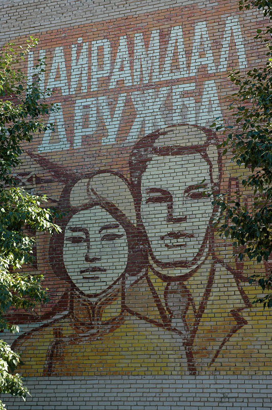
Communist Mural, Darkhan, Darkhan-Uul Province, Mongolia
We reach Baruun-Urt after midnight and camp in a patch of open ground in the centre. In the morning Bayarmaa, who is very apologetic for the predicament we have found ourselves in, helps us get our permits to drive to the capital, then even buys us lunch and introduces us to her family. The road out of town starts off as a dirt-track, but after a few hours becomes the asphalted main highway which will one day run right across the country. Jacob and I drive on into the night and have a final dinner together before stopping in the town of Öndörkhaan, capital of the province of Khentii from which Chinggis Khan is said to hail, where we part. Jacob has been a fantastic travel partner and I’m truly glad to have had him along for the seven weeks we’ve spent touring nearly the entire country. It’s a sad parting but my time in Mongolia is up (for now), while Jacob will continue to explore the north of the country before heading on to China and Pakistan.
I drive right through the night, during which I see my first frost of the year, pausing in Ulaanbaatar at dawn to refuel, then taking the road north to the Russian border. Soon after the road forks north at the westernmost edge of the capital, the landscape changes to one far more reminiscent of Siberia than anything I have yet seen in Mongolia; stands of yellowing larch trees stand on the grassy hilltops, farmers cut and gather grass from fields and birch trees, tied with colourful votive rags, line the roadsides. Occasionally a marvellous golden carpet of wheat covers the hillsides, and I see mechanised farming for the first time. The air is crisp and the sun’s rays long; autumn has begun here already. It’s a world away from the austere but magnificent plains of the Gobi, which I immediately miss.
By early afternoon I reach the small city of Darkhan, built from scratch by the USSR in 1961 as a second centre of manufacturing in Mongolia. It’s a nicer place than much of the capital though of no real interest, and after having a good meal I continue north. I camp alone near the roadside in a field; it feels rather odd without Jacob and I realise that without company, my experience in Mongolia would have been rather lonely – not a word I use very often at all.

Landscape, near Sükhbaatar, Selenge Province, Mongolia
In the morning I continue my journey north through the rolling, almost bucolic landscape of Selenge Province, named for the river which flows north into Lake Baikal. Approaching the capital, Sükhbaatar, I lose my patience behind a crawling Mongolian driver and pass him on a railway crossing right in front of a traffic cop. The fine is just a few dollars and I have no grounds to argue it, and it thus becomes the first and last traffic infraction I would pay for on the entire journey. I’m actually laughing to myself about this as I drive out of town, only for a shepherd boy who is sitting by the roadside to notice this and, perhaps feeling self-conscious for a moment, raises his middle finger; not the nicest finale to my first trip across Mongolia.
The border at Altanbulag is busy and Mongolian Customs are so slow that there is a considerable jam of traffic. I am on the last day of my visa and so make another call to the British Embassy, and am soon waved to jump the queue. I have been very pleasantly surprised by how useful the Embassy has been in the last few days and finally feel I’ve recouped some of the swingeing embassy fees I paid for my passport in Islamabad two years earlier.
And so with just an hour left, I slip out of Mongolia. Fascinatingly different from any other country I have visited, stunningly beautiful but continually challenging and frustrating, travel in Mongolia is an almost addictive experience, and my first goal when entering Russia will be to obtain another Mongolian visa, and make a second pass across the country.

Nice post thannks for sharing