
Stage 41 – Turkey, Georgia & Azerbaijan: From The Black Sea To The Caspian

Upon returning to the UK back in November 2014, I had put the truck in storage and within days was flying to start a new job, my first in almost eight years. Although this necessitated basing myself a singularly charmless part of northwestern Europe, the job as a geoscientist for a large energy company offered the possibility of relocating internationally in the future and, of course, a chance to replenish my bank balance after years of travelling. Most appealing in the short term however, were the generous holidays and so after less than six months in the position, I was able to use my annual leave to make a trip of almost nine weeks, focussing on a return to Russia to make a south-to-north journey across the country. After taking the truck out of storage, I departed from the office car park on the afternoon of the 8th May 2015, stopping with my cousin in Jena, Germany, then continuing the next evening, roughly retracing my route from November of the previous year to the Turkish border.
This first stage of my 2015 journey would take me rapidly across northern Turkey, weaving between the dramatically beautiful Black Sea coastline and the rugged interior of northern Anatolia. Then, from the striking mountains of Turkey’s north-east, once part of an ancient Georgian kingdom, I would enter Georgia, climbing from the Black Sea to drive across the country into Azerbaijan and on to the shores of the Caspian from where, after a brief trip into the eastern Caucasus, I would enter Russia.
Safranbolu, Karabük Province, Turkey
I cross the Turkish border at Kapikule on the afternoon of the 11th May 2015, driving across the rolling landscape of Thrace towards the bottleneck that is Istanbul. I’m sucked into the fast-moving traffic of the city’s sprawling western suburbs where I make good progress towards the centre but miss a critical turn which would have taken me to the ferry port in Sirkeci, and instead get lost in heavy traffic just north of the centre. I make my way into the gridlock approaching the Bosphorus Bridge, and emerging some time later on the city’s Asian side, become lost again in the back-streets of Kadıköy until I realise that the name ‘Çevreyolu’ refers to the main road I have been searching for rather than a city unmarked on my maps, and finally exit Istanbul late in the evening, heading east into Anatolia.
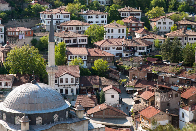
On the following day, the road takes me through beautiful forested hills, passing the turning south to the capital, then leaving the main highway to stop in the beautiful town of Safranbolu, which nestles in a small gorge and has a preserved centre of white-washed Ottoman-era houses with wooden window frames and terracotta-tiled roofs. Safranbolu is something of a tourist town, popular mostly with domestic tourists, but it’s out of season and with the pleasant warmth of early summer and cloudless deep blue skies, it makes a wonderful place to stop and rediscover one’s senses after months of appalling weather in the blandness of Western Europe.

Black Sea Coast, Cide, Kastamonu Province, Turkey
From Safranbolu I drive north, crossing the rolling slopes of the Pontic Mountains which are richly covered in dark pine forest with contrasting patches of bright lime-green from beech trees newly in leaf. Perched on some of these slopes are rustic half-timbered houses above small clearings and villages where time passes slowly; where the elderly sit under shady trees and dogs doze at the roadside. I join the D010, the coastal highway, and above the town of Amasra get my first dazzling view of the Black Sea. I stop for a moment at the Kuşkayası Monument, hewn in the first century CE from the native limestone and consisting of a now headless Roman eagle and headless Roman figure who may have been the emperor or provincial governor.
Having long been cut off from the interior by the Pontic Mountains, with access far easier by sea than by land, the Black Sea Coast has a history somewhat distinct from the rest of Anatolia. A prehistoric crossroads between the Mediterranean world, the Eurasian Steppe and the Caucasus, the earliest history comes from the Greeks, who named it the Euxine or ‘hospitable’ sea and settled what is now the north coast of Turkey starting in the early first millennium BCE. These coastal colonies of the Ionian Greeks (centred on what is now Turkey’s Aegean Coast) would become part of local kingdoms; Bithynia in the west and Pontus in the east, spreading around the coasts of what is now Georgia, Russia and Ukraine. In the first century BCE these were combined and incorporated into the Roman province of Bithynia and Pontus, and it is from this period that the Kuşkayası Monument dates.

Harbour, Sinop, Sinop Province, Turkey
Amasra is a charming small town whose harbour is surrounded by Byzantine and Genoese fortifications, but I stop only for a brief walk before continuing eastwards. The coastal highway is stunningly beautiful, at times narrow where it hugs the cliff-tops with views along indented bays, then dropping down to quiet seaside towns such as Cide, with its long, empty pebble beach at the foot of a dramatic coastline. Further east, the road climbs once more into the fragrant forest of the mountains’ lower slopes, giving magnificent views over the gleaming turquoise of the Black Sea, which here I find even more picturesque than the usually deforested coastline of the Mediterranean. After an overnight stay in the town of Ayancık, on the following morning I reach the small city of Sinop, located on a large headland forming the northern-most point of the coastline.

Yeşilırmak River, Amasya, Amasya Province, Turkey
Sinope was founded as a Greek colony in approximately the seventh century BCE and would go on to become one of the capitals of the pre-Roman Kingdom of Pontus, ruled by the Persian Mithridatic Dynasty who are thought to have descended from the Achaemenids. Somewhat larger than Amasra, I find Sinop an immediately likeable place with its compact, walled centre and beautiful harbour, gently busy with fishing boats and with a magnificent view back towards the emerald-coloured mainland as a backdrop. In the afternoon I drive inland, through a winding valley dotted with rice paddies and brush-like poplar trees, climbing to the city of Amasya. Also a capital of Pontus, and birthplace of the Greek geographer Strabo, unlike Sinop, Amasya was a place of importance well into Ottoman times. Situated on the banks of the Yeşilırmak River in a scene which reminds me somehow of Kabul, Amasya retains an elegant, if slightly over-restored river-front of Ottoman houses. Above this rise almost sheer cliffs which in the third and second centuries BCE were carved into the necropolis of the Pontic royal family, in a tradition similar (though less elaborate) to their Achaemenid forebears in central Iran.

Christ Teaching In The Temple, Hagia Sophia, Trabzon, Trabzon Province, Turkey
I drive initially east from Amasya, then turn north and cross the Pontic Mountains once more via the Eğribel Pass, where in places there is still more than a metre of snow along the road-side, dropping through a steep limestone gorge and more thickly forested mountains, down to the coast just east of Giresun. This eastern stretch of the Black Sea Coast is very much more developed than that which I have passed through so far, and the coastline less attractive, but the views eastwards towards the snow-capped mountains near the Georgian border are captivating.
By late afternoon I reach the city of Trabzon, the most famous of Turkey’s Black Sea cities. Also founded by Greek colonists in the eighth century BCE, the city’s heyday would come long after, as seat of the Empire of Trebizond, a successor state of the Byzantine Empire following the disastrous sacking of Constantinople by the Latin (Roman Catholic) Fourth Crusade in 1204. Later in the thirteenth century Trebizond would become fantastically wealthy as a result of trade routes across Anatolia being pushed northwards by the Mongols, with Venetian and Genoese merchants (such as Marco Polo) receiving goods from the Silk Road in the city’s port. Trebizond was a place of luxury and high culture; an oasis with a mainly Christian population in the Turkish heartland of Anatolia until its conquest by the Ottomans in 1461, who in overthrowing Trebizond, put an end to the Byzantine Empire and a tradition which had started with the Romans almost 1500 years earlier.
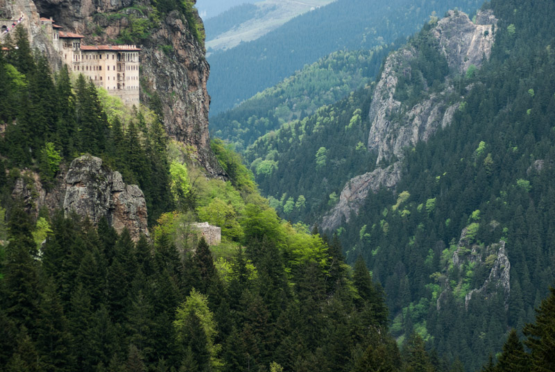
Sumela Monastery, Trabzon Province, Turkey
There are few outward signs of this historical richness in modern Trabzon, but in a park planted with palm trees at the side of the coastal highway one finds the thirteenth century Hagia Sophia Church, far more restrained than its namesake in Constantinople but nevertheless a beautiful piece of late Byzantine architecture with well restored frescoes, thankfully still on display despite the church recently being controversially reinstated as an active mosque. Following the Ottoman takeover, Trabzon’s Pontic Greek community slowly declined as a result of voluntary emigration and conversion. Imperial Russia, which had long coveted the southern coast of the Black Sea, launched numerous wars with Ottoman Turkey in the nineteenth and twentieth centuries and the region’s Christian population frequently supported the invading Russians. These actions no doubt contributed to the atrocities committed against Christians in the closing days of the Ottoman Empire, with Trabzon witnessing the deportation and genocide of Greek and Armenian populations as part of a greater tragedy which was replayed all across central and eastern Turkey.
The Pontic Mountains have been a refuge for monastic Christianity since the beginning of the Byzantine period, and I stop on my way south at the gorgeously located Sumela Monastery, said to date originally from the fourth century, which clings iconically to an almost sheer cliff in a steep, forested valley of the Pontic Mountains. To my dismay, the approach to the monastery is thronging with tourists, to the point where I consider leaving, but I persevere. Entering the inner courtyard of the monastery, behind the facade of the dormitory and refectory which are visible from the valley below, one enters a small courtyard in the shadow of the overhanging cliffs, out of which the original Rock Church has been partly carved. Both exterior and interior of the Rock Church are densely covered in frescoes, including a huge Christ Pantocrator on the cave-ceiling within, though there is plenty of evidence of vandalism and graffiti (much of it in Greek script) dating from after the monastery was abandoned in 1923 upon the deportation of the Greek population.
Yakutiye Madrasa, Erzurum, Erzurum Province, Turkey
Leaving Sumela, I continue inland, crossing the Zigana Pass and driving south-eastwards into the mountains and treeless steppe of the interior, towards the city of Erzurum. Despite years of overland travel in Eurasia, this is my first visit to a city which lies firmly on the Great Eurasian Overland, lying on the main route between Istanbul and Tabriz. I’d long imagined that Erzurum to be another bland and shambolic Kurdish city, but I soon find this to be quite wrong. I’m hosted by Ahmet, a Kurdish student who introduces me to a group of his friends, who take me out to eat the city’s famous Cağ Kebab, a horizontally rotating Döner Kebab which apparently originates from Erzurum. We then walk briefly around the city centre before retiring to a low-ceilinged tea house, where we recline on cushions for all-male conversation in an atmosphere thick with tobacco smoke.
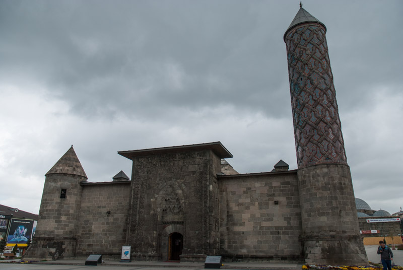
Erzurum is located on a windswept grassy plain flanked to the north and south by rows of snow-capped mountains and feels somewhat depopulated, with what appears once to have been the centre now mostly a collapsing expanse of old buildings, derelict or half-demolished, surrounded by a jumble of bland modern apartment blocks. In amongst this however are a clutch of glorious medieval monuments, such as the imposing bulk of the fourteenth century Yakutiye Madrasa dating from Ilkhanid times, which manages to juxtapose brutal, militaristic bulk with fine and intricate decorative detail. Inside the former seminary, now an art museum, the stonework is magnificent with graceful stone arches and an ocular skylight surrounded by finely carved muqarnas (corbels).

Grasslands, near Erzurum, Erzurum Province, Turkey
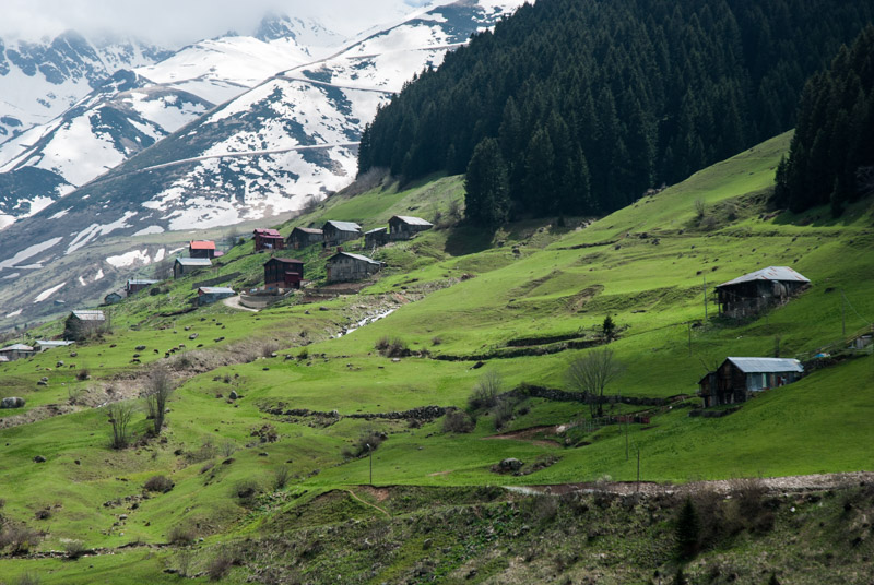
Driving north out of Erzurum, one crosses a high grassland plain grazed by cattle and backed by snow-streaked mountains, a beautiful scene which must have stirred the souls of the nomadic Turks and Mongols who arrived here from the steppes of Central Asia and made Erzurum their home. Soon after crossing a low pass the landscape changes dramatically to the steep rocky valley of the Tortum River, planted with walnuts and poplars and irrigated by milky glacial streams. This also marks what was historically a cultural boundary, into a region which is regarded as an ancestral homeland by the Georgians. These valleys of north-eastern Turkey were part of the ancient Georgian Kingdoms of Iberia and Colchis, which would become part of the Achaemenid, Roman, Byzantine, Sassanian and Arab Empires. It was in this region north of Erzurum, then the Principality of Tao-Klarjeti, that the roots of a unified Georgian state would emerge in the early ninth century CE. It was here that the Bagratid Dynasty (who also contributed leaders to the Armenian line) established a Georgian prince, the descendants of whom would oversee a cultural flourishing of Tao-Klarjeti in the late tenth century, then in 1008 under Bagrat III the establishment of the first unified Georgian state and an end to centuries of power struggles.

Otkhta Monastery, Dörtkilise, Artvin Province, Turkey
Today the remains of this cultural high period of Tao-Klarjeti, built during the reign of King David III in the tenth century lie in various states of ruin in these beautiful valleys of the southern Pontic Mountains. I start by visiting the large and well preserved church of Khakuli, now a mosque, in whose cold interior I listen to a man reciting verses from the Quran. Nearby, the even larger but ruined cathedral of Oshki stands in the middle of the village of Çamlıyamaç, its broken roof allowing in alternating rain showers and shafts of sunlight to illuminate its exquisite stonework. Further north, above the Oltu Valley is the church of Ishkhani, but its clumsy restoration by Turkish authorities has rather robbed it of both poignant dereliction and its original grace. The fourth and final church which I visit is however my favourite; situated further to the east in the Çoruh Valley, reached up a steep unpaved road beyond the village of Dörtkilise, the monastery of Otkhta sits in dignified ruin seemingly almost consumed by burgeoning spring-time vegetation like a Christian Angkor Wat, sitting alone among a few garden plots and vertical scenery. The interior of Otkhta, whose walls retain traces of frescoes, bears the definite smell of livestock and its a rather ignominious fate for such a glorious building, but such is the history of cultural decline across much of eastern Turkey. As the balance of power shifted around the borders of medieval Georgia, it would become once more fractured and a vassal of regional empires in the fifteenth century. The region of Tao-Klarjeti would be absorbed into the Ottoman Empire in 1545 and aside from a forty-year period of Russia rule, would stay under Muslim rule until the present day.
Pontic Mountains, Sivrikaya, Rize Province, Turkey
I spend the night next to Otkhta, and in the morning continue along the beautiful Çoruh Valley, dotted with ruins of ancient Georgian castles. Turning north just after İspir I climb into a winter landscape of blinding white snow, crossing the 2650 metre Ovit Pass and descending through the beautiful İkizdere Valley, where villages of wooden houses cling to the steep grassy mountainsides, then descend to the balmy warmth of the coast through striking, lime-green tea plantations near Rize, where I turn eastwards once more towards the Georgian border. This far-north-eastern region of Turkey is home to yet more minorities; the western Georgian Laz People, thought to descend from the ancient Colchians, and the Hemshins, highlanders thought to be descended from medieval Christian Armenians. It’s late afternoon by the time I reach the Georgian border crossing at Sarp and less than an hour later, I’m in Sarpi, Georgia, watching a beautiful cloudless sunset over the Black Sea.
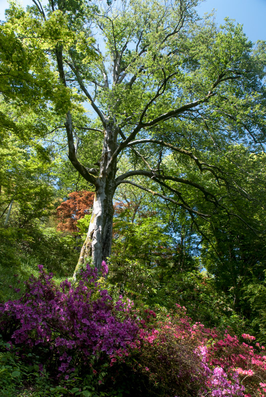
Botanical Gardens, Batumi, Adjara Autonomous Republic, Georgia
I stop in Batumi, Georgia’s second largest city, for three nights, taking a break from the rather brisk pace of travel I have kept up on the trip so far. Batumi was established as a Colchian-Greek colony but has no outward signs of age, and currently has the air of an out-of-season tourist resort with a seafront of bold, modernist buildings, an unremarkable pebble beach and a mixture of new and old architecture; a far cry from the exotic beauty of Abkhazia or some parts of Crimea, but a pleasant place to spend two relaxing days nonetheless. The Georgians here are as I remember them; driving around town flat-out in ailing European cars, but are otherwise strangely unobtrusive and the air of progress and change which I have noticed on previous visits to Georgia seems somewhat diminished here.
One real highlight is Batumi’s magnificent Botanical Garden, established in the nineteenth century by a Russian botanist and located a few kilometres north of town, which I visit on my second day in the city. The gardens consist of glowing hillsides of species from across the world, though those from East Asia and North America are the most vividly beautiful; giant magnolias and sequoias, rhododendrons, azaleas, japonicas, cedars and palms, all looking out across the limpid blueish waters of the Black Sea on a day when sea and sky merge seamlessly at the horizon and the verdant green hills of Georgia stretching off into the haze to the north look like something of an Earthly paradise.

Khulo, Adjara Autonomous Republic, Georgia
Batumi is in fact the capital of the Adjaran Autonomous Republic, commonly known as Adjaria, which spreads up into the Lesser Caucasus Mountains behind Batumi and along the Turkish border. The Adjarans were once subjects of the Ottoman Empire and were distinguishable for having adopted Sunni Islam, though nowadays the majority of Adjarans are Orthodox Christians and the environs of Batumi look no different from anywhere else in Georgia. I leave Batumi and drive west, climbing away from the Black Sea for the last time, into the Adjaran hinterland. As I climb up the Acharistskali Valley I pass attractive, sprawling villages with large stone hoses perched on steep hillsides above neat garden plots, in places almost idyllically beautiful with views over the yawning valley. In the town of Khulo I notice for the first time a large mosque with an Ottoman-style minaret (no doubt funded at least in part by Turkey), which looks somehow odd against the rural Georgian landscape, but I suspect that religion is worn lightly by the region’s inhabitants. Beyond Khulo the road climbs above the level of permanent settlements into a landscape which seems only recently relieved of its winter snow-cover, and I stop on the Goderdzi Pass at around 2000 metres elevation to watch a cow-herd trail his cattle up the steep grassy mountainside in front of me, with a stupendous backdrop of still snow-capped mountains to the north and the wooded valleys of Adjaria far below.

Goderdzi Pass, Adjara Autonomous Republic, Georgia
Once over the pass it’s a long and rather less scenic drive through central Georgia, dropping down to Akhaltsikhe and then on via Borjomi to Mtskheta where I stay for a night with Gerhard and Julia, with whom I had stayed several times last year. I continue the following day, taking the bypass around Tbilisi and crossing out of Georgia and into Azerbaijan on the main road to Baku. I’m a little disappointed at the Azerbaijani border to notice that (in contrast to my two previous experiences entering the country) it is visibly corrupt, with money and bottles of drink changing hands between passengers and the customs officers, who seem like the typical half-educated idiots of a police state. My negative impressions are furthered when, not long after driving away from the border, I’m stopped by traffic police for some farcical traffic infraction and made to hand over some cash in the back of their patrol car. Whilst neighbouring Georgia and Armenia have moved firmly on from the Soviet period and opened up to the outside world, it is Azerbaijan, by far the richest of the three countries, which remains mired in the insular mentality and shameless corruption which marked the era of the Soviet collapse.

City Administration Building, Ganja, Ganja-Qazakh Region, Azerbaijan
I reach the city of Ganja after dark, which has the slight Potemkin-esque atmosphere of a large city in a dictatorship; the statue of First President Heydar Aliyev and accompanying museum, the de-Sovietised City Administration Building set in a vast square, a limited range of shops along a paved and well-lit main street, but otherwise no real civic investments and dark back-streets of broken roads and shabby housing. As ever though, the people of Azerbaijan are extremely friendly, and curious to meet a rare foreign visitor. After eating a kebab and having a short walk around Ganja, I leave, and after some difficulty navigating the totally unsigned city streets I return to the main highway. Managing to avoid any further encounters with the police, I reach Yevlakh and turn south, stopping for the night just before reaching Barda.
Barda, formerly known as Partav, was once the capital of Caucasian Albania, a historical kingdom whose territory covered much of modern Azerbaijan and of which much remains unknown, including the kingdom’s origins and even its endonym. Like other Caucasian nations it was a vassal of larger regional empires (usually Persian), and has recently become the rather unfortunate subject of Azerbaijani historiography which falsely claims much of the region’s Armenian heritage as being ‘Caucasian Albanian’ in an attempt to refute the historic presence of Armenians in Nagorno Karabakh and Nakhchivan.

Akhmad Zocheybana Mausoleum, Barda, Aran Region, Azerbaijan
I reach Barda early the next morning and watch a sleepy provincial town come to life, with butchers cutting up carcasses on the street-sides, children fetching bread and women sweeping with hand-made brooms. Following the Arab takeover of Persia in the seventh century, Barda retained its importance as a centre of trade but was subject to raids, most curiously by the Varangians of Rus’ in 943, who occupied the city until being forced to return by an outbreak of dysentery, but more seriously by the Mongols and Timur who devastated the city. I make my way to Barda’s only surviving monuments; a fragment of ancient mud-brick wall allegedly of Albanian age, and the beautiful tomb tower of Akhmad Zocheybana which is covered in turquoise-tile Kufic faïence and undergoing a much-needed restoration. I also look into the rather plain nearby Imamzadeh (Shia shrine), built by the same architect as the now derelict mosques of Shushi and Agdam in Nagorno Karabakh which I had visited last year. I watch pilgrims process anticlockwise around the green-cloth covered tomb of an ancient holy man; an example of the public revival of Iranian-influenced culture of shrine-visiting.
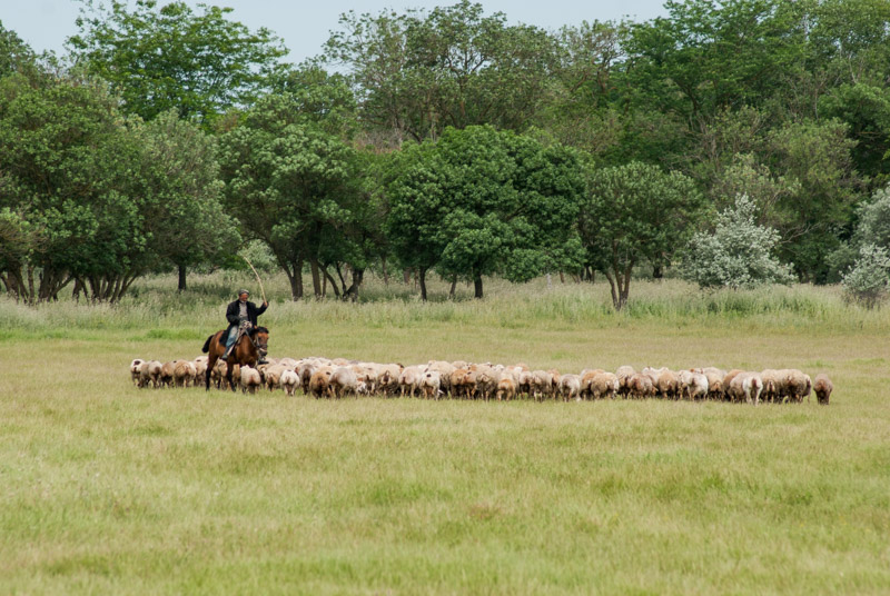
Shepherd, near Bahramtepe, Aran Region, Azerbaijan
I leave Barda heading southwards and begin to deeply enjoy rural Azerbaijan, which grinds along to an ancient routine. Men on foot or on horseback herd sheep and cattle over the flat plains made green by the water of the Aras, brought in brown torrents by a system of irrigation channels. The air has the scent of woodsmoke and the herb esfand which is burned to war off the evil eye, and this, together with the lumpy Soviet-era roads give me the strong sensation of being in Central Asia. Always off to the west are the misty, greenish mountains of Karabakh, the loss of which weigh heavy on the heart of Azerbaijanis. Road-signs are still in place for destinations such as Füzuli and Agdam which have been razed to rubble, and others such as Khojavand (Martuni) and Khankandi (Stepanakert) which are firmly settled by ethnic Armenians. Even the buses still show destinations in Nagorno Karabakh, despite them lying totally out of reach beyond a tense cease-fire line.
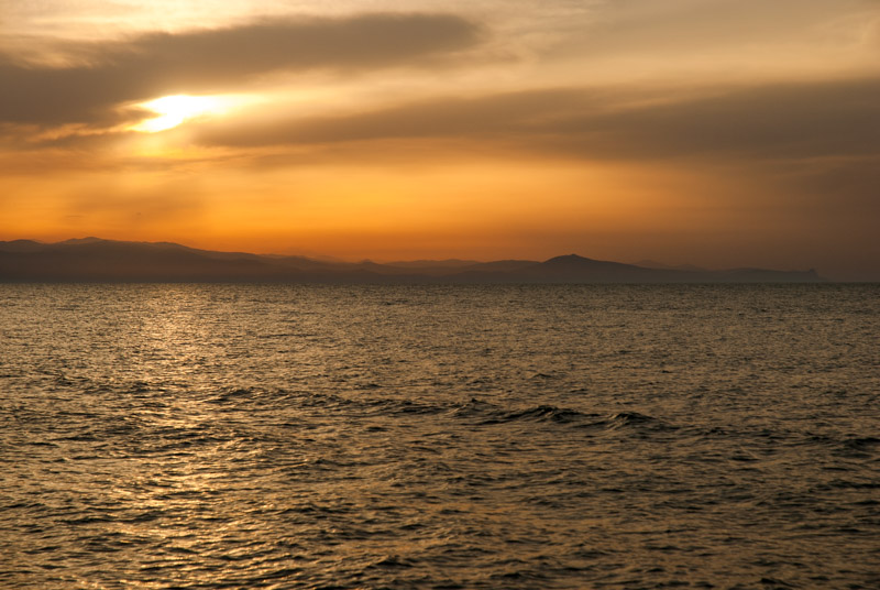
Sunset, Pirshagi, Absheron Region, Azerbaijan
The road reaches its southernmost point around the town of Bahramtepe, close to the Iranian border, then turns north-eastwards towards the capital, becoming busy with slow-moving lorries and leaving behind the irrigation canals, passing through a number of dull towns in the dry landscape. Later, a range of parched dry multicoloured hills come into view in the hot, dry air and the landscape is dotted with nodding pumpjacks. In the afternoon I re-join the main highway, here a new dual carriageway which is woefully lacking in exits, no doubt making life difficult for those who live alongside it, though in a country as corrupt as Azerbaijan these people clearly matter little; the road is for the benefit of the rich cadres and cronies of Baku. After a detour and some backtracking thanks to a total lack of signposting I reach the petroglyph site of Qobustan which has a distinctive set of humanoid figures with strange frog-like legs; interesting but somehow less spectacular than the remote rock-art sites of Central Asia and Mongolia. On my way out I stop to look at a lone stone in a barren landscape, unremarkable but for having been inscribed in Roman times; the easternmost Roman inscription ever found.
Rejoining the main highway, I bypass the centre of Baku, which I had found to be a vulgar and ostentatious city on my visit in 2010, and head instead for the chaotic roads of the Absheron Peninsula, much of which is now a sprawling extension of the capital. I drive onto the beach in the northern suburb of Pirshagi which is apparently a popular holiday spot, though the less-than-clean sand is backed by a goat-grazed wasteland of litter and sewage. The sunset view across the turquoise water of the Caspian towards the eastern edge of the Caucasus Mountains is however magnificent, and I decide to stay for the night.

Ateshgah, Surakhani, Absheron Region, Azerbaijan
The Absheron Peninsula presents a truly blighted-looking landscape; dismal parched ground with putrid salt lakes, an ever-present bitter, sulphurous stench in the air, and sprawling formless towns choked with heavy traffic on pot-holed, poorly-planned roads. Absheron is however a land rich in hydrocarbons, which spew naturally from the brackish earth. The peninsula’s oil has been exploited for well over a thousand years, was the focus of Eurasia’s first oil boom, and was one of the prizes Hitler sought when he invaded the Soviet Union in 1941. I visit a few sights relating to this natural abundance of hydrocarbons, firstly the Ateshgah or ‘fire temple’ in Surakhani which seems to have been built in the sixteenth or seventeenth centuries by Hindu immigrants from India around a (now exhausted) natural gas flare, and is recorded as having been worshipped by Sikhs and Zoroastrians as well as Hindus. I then drive northwards through a forest of oil derricks to a curiosity known as Yanar Dag, where a burning flare of natural gas escapes along a short section of exposed sandstone. Most interesting however is a particularly desolate area nearby, where oil streams from a natural seep down a hillside. I walk up to the top of the hillside and see a landscape cratered by the remains of hand-dug oil wells dating from the nineteenth century, before the invention of modern drilling techniques, when oil was exported to Persia. From this vantage point, across the wasteland of Absheron is the modern skyline of Baku, now rich from oil produced by offshore fields under the Caspian.
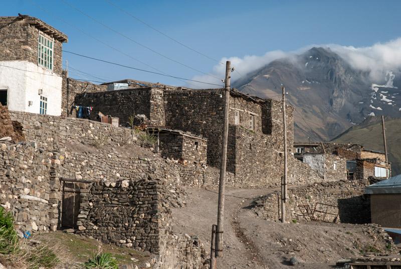
Khinaliq, Quba-Khachmaz Region, Azerbaijan
Heading north through Sumqayit and leaving the Absheron Peninsula, the land starts to green once more as I climb slowly inland, passing through the attractive town of Quba on the Gudyal River. The road out Quba steepens immediately, entering beautiful beech forests popular with domestic tourists, who ruin the tranquillity with blaring low-quality music and piles of litter. Not far beyond however, the road leaves the villages and begins to climb steeply into the highlands, a spectacular landscape of flowing, treeless emerald hillsides grazed by great herds of sheep, with distant views of the snow-capped eastern peaks of the Caucasus. I stop at the end of the road, in the village of Khinaliq, which sits at an altitude of around 2100 metres. Although some modern buildings have cropped up, much of the village consists of traditional dry-stone houses, some terraced one above another, looking very much like a Dagestani aul (fortified village). Khinaliq is a very ancient settlement and its pale-skinned people speak their own language, which may even be a language isolate. I walk around the very friendly village enjoying the fresh air and magnificent views to cloudy mountain peaks, walking on ancient trails between the stone houses against whose walls are often stacked large piles of dung patties, an essential fuel source in this totally deforested corner of the Caucasus.

Gudyal River, Quba-Khachmaz Region, Azerbaijan
The beautiful mountain atmosphere and friendly villagers make me wish I could stay some time in Khinaliq, but I’m limited by customs restrictions to seventy-two hours in the country with the truck. I camp nearby however, on the broad bed of the Gudyal River, looking up the valley towards the mountains on the Russian border. In the morning, after a few hours relaxing and admiring the scenery, I descend once more to Quba and have a quick look around. It’s a pleasant place with unfailingly friendly people, like everywhere I have encountered in Azerbaijan, but the real point of interest for me is the town of Qirmizi Qasaba, lying on the far side of the river. Qirmizi Qasaba is inhabited entirely by Mountain Jews, thought to be descendants of Persian Jews who themselves were descended from the ancient Israelites who were exiled to Babylon by the Assyrian King Nebuchadnezzar in the sixth century BCE. Escaping persecution, the Mountain Jews began to move to various isolated valleys of the Caucasus in around the fifth century CE where they have lived ever since. In the nineteenth century they escaped the rules of the rest of the Russian Empire which forbade Jews from farming and were even in some cases spared by the Nazis in the Second World War, who were unsure as to whether the Mountain Jews were ‘Racial Jews’.

Mountain Jew, Qirmizi Qasaba, Quba-Khachmaz Region, Azerbaijan
Today Qirmizi Qasaba is one of the last strongholds of the Mountain Jews and, although not populated by Yiddish-speaking Ashkenazi Jews, could be regarded as the world’s last shtetl. It’s perhaps slightly tidier and wealthier looking than the rest of Quba, but only the unassuming Grand Synagogue hint at the town’s unique demographics. The inhabitants too look and dress little different from other Caucasians, but they retain their own language, Judeo-Tat, a Semitic influenced form of Persian.
My seventy-two hours in Azerbaijan is coming to a close, and so I make the final drive north through a string of villages on the undulating plains between the mountains and the sea, to the customs post at Samur. Only recently made a multilateral border crossing, I approach the border with some trepidation; after all this is the border between one of the world’s most corrupt countries and the most corrupt region of Russia. However, after a thorough search I’m free to proceed across the Samur River on a boxcar bridge which reminds me of crossing the border between Afghanistan and Uzbekistan, somehow making the crossing seem more momentous than it really is.
I’ve greatly enjoyed my journey from the Bulgarian border to the Samur River; the astoundingly beautiful and historically interesting Black Sea Coast of Turkey; yet more beautiful landscapes in Georgia, and then a second transit across ‘mainland’ Azerbaijan, a country which though wealthy from its natural resources, is visibly held back by corruption when compared to its neighbours. I would like to spend longer in the country but am held back from doing so by restrictive bureaucracy, which shows how little interest the government has in welcoming foreign visitors. Whilst the people of Azerbaijan are perhaps the most friendly in the South Caucasus, I still cannot bring myself to like the place quite as much as I like Armenia and Georgia.
What has also been apparent to me on this trip is that my pace of travel has been slightly too rapid, and so I look forward to the next stage of the trip, moving slightly more sedately across the vast tracts of European Russia, all the way to the Barents Sea, well above the Arctic Circle.
Stage 40 – Turkey: Mesopotamia To Thrace [2/2]
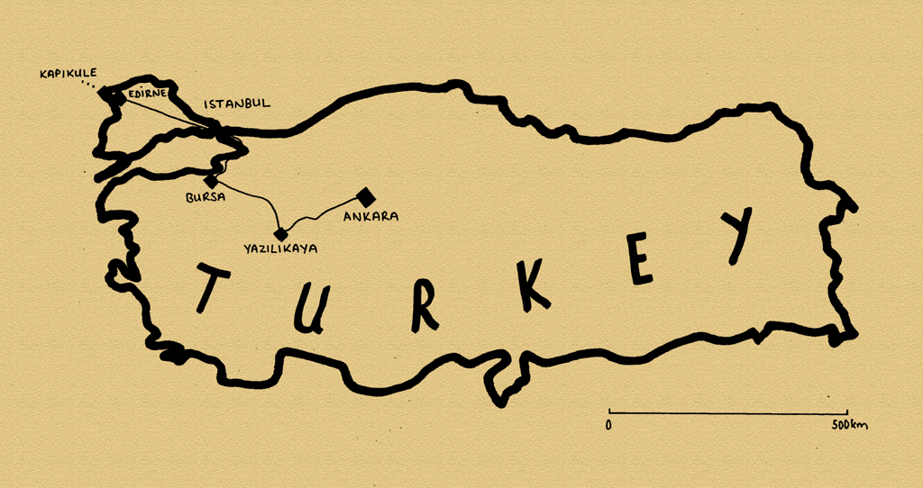
Having crossed much of Turkey on the way from the Iraqi border in the far south-west to central Anatolia, I arrive in the capital, Ankara. The last two weeks of my 2014 journey will take me from here across western Turkey, past monuments of the semi-legendary Phrygians, then through three former Ottoman capitals; attractively sited Bursa; Istanbul, one of the very finest cities in the world and Edirne on Turkey’s frontier with the EU. Whilst not as ruggedly beautiful or culturally varied as the country’s east, this short journey across Turkey’s modern, western face would reveal much of the history of the Byzantine and Ottoman Empires, which together stretched from Antiquity until the early twentieth century.

East Gate, Ankara, Ankara Province, Turkey
It’s the 2nd November 2014 as I enter Ankara from the east on a cold, clear night, driving across the city centre to the home of my friend İnanç. I first met İnanç more than seven years ago at the very beginning of the Odyssey when he hosted me for a few memorable days in Almaty, Kazakhstan where he was working as a construction engineer. Following several years working in Kazakhstan and Russia, then travelling, İnanç has recently returned to his parents’ home in Turkey and will now be my host in his native Ankara.
Ankara is an ancient settlement and was known to the Hittites and Phrygians, but it was during Roman times that the city flourished, lying in the heart of Anatolia at the junction of north-south and east-west trade routes. In Ottoman times it languished as something as a backwater, but it would be made the base of an interim Turkish government by Mustafa Kemal during the Turkish War of Independence, when the Allied Powers sought to partition the Ottoman Empire among themselves. Following his victory, in which he retained the Ottoman territory in Anatolia to form the new Turkish Republic, Mustafa Kemal made Ankara its capital in 1923.

Rooftops, Old City, Ankara, Ankara Province, Turkey
We start late the following morning and head for the centre of the city, which is filled with government buildings, company headquarters and bustling streets of commuters. It’s an attractive and well-organised place but is very clearly a modern, purpose-built capital, without the romance or beauty of Istanbul. Overlooking the centre of town is ancient Ankara Castle, and we walk up steep steps through vivid yellow horse-chestnut trees and pass through a gate in the castle walls which seem to have been repaired at some point with what look to be recycled Roman gravestones. From the top one has a wonderful view over the winding streets of Ankara’s old centre, a sea of terracotta-roofed houses rather like an up-scaled Anatolian village.
In the afternoon, we walk across the centre to visit the mausoleum complex of Turkey’s founder, which is known as Anıtkabir (Memorial Tomb). When the victorious Mustafa Kemal set up the modern Turkish republic from the ashes of the Ottoman Empire, he introduced stringent political, economic and cultural reforms, forging a republic based on secularism and nationalism rather than religion. In 1934 he was given the name Atatürk (Father of Turks) by the Grand National Assembly and was central to the progress and identity of this young nation state. It was mostly after his early death in 1938 however that his name and portrait, with high hairline, piercing blue eyes and upswept eyebrows, was turned into something of a cult of personality which very much persists to the current day, even with the country currently seeming to fall back towards religious conservatism.

Anıtkabir, Ankara, Ankara Province, Turkey
One approaches Anıtkabir through a large manicured park along the Road of Lions with replicas of Hittite Lions representing power and peace, from a pre-Islamic, Anatolian civilisation whose borders were similar to those of modern Turkey. One then reaches the huge Ceremonial Plaza whose perimeter is lined with long, colonnaded galleries and whose floor is an expanse of polished stone drawing the eye to the imposing Hall of Honour, the actual mausoleum of Atatürk which sits on a stepped pedestal like a modernist temple. In the plaza mill tourists, groups of schoolchildren and troops of guards but the human form is dwarfed by its size and the vertical pillars of the mausoleum behind which is draped a huge Turkish flag. Inside are exhibits from Atatürk’s remarkable political career but his tomb, in a forty ton sarcophagus, is not on public display. In the evening, I am invited by İnanç and his parents to a large family gathering and end a great day in the company of his extended family eating excellent food and wishing I could speak some Turkish.

Sihhiye Square, Ankara, Ankara Province, Turkey
In the morning we head back into the city centre to visit the Museum of Anatolian Civilisations. Here, in one of the best museums I can remember visiting, one finds a plethora of artefacts from archaeological sites and ancient buildings across Anatolia. Most impressive are a collection of Hittite bronzes, particularly the distinctive ‘sun discs’ from nearby Alacahöyük. There are also Bronze Age female fertility idols, Hittite pottery, Phrygian earthenware, reliefs from the Neo-Hittite and Assyrian Empires, a carving of Assyrian King Mutallu and Urartian ivories, among many others, which keep me rapt in the museum until closing time. One sees touches of these ancient civilisations across modern Ankara, such as the large Hittite Sun Course Monument in Sihhiye Square, depicting a stag with stylised horns seen in Bronze Age petroglyphs as far away as Mongolia. Before leaving Ankara, I pay a visit to another friend, Ezgi, a course-mate from my Masters degree in London who now works for the state oil company. A native of Istanbul, she tells me she finds Ankara rather dull and provincial, a far cry from vibrant Istanbul.

Midas Monument, Yazılı, Eskişehir Province, Turkey
İnanç and I leave Ankara together, heading south-west out into the beautiful Anatolian countryside on a mild and cloudless day. We pass Polatlı, close to the ancient Phrygian capital of Gordion, home of the legendary Gordian Knot. Tied by farmer-come-king Gordias, an oracle had foreseen that the knot would be undone by a man destined to become king of all Asia and it was supposedly sliced open by Alexander the Great on his march east towards Persia. We turn off the highway and onto small provincial roads, stopping in the town of Çifteler for lunch at a lokanta (canteen) and continuing to the village of Yazılı. Set amongst soft outcrops of yellow limestone, overlooking a small wooded gorge, Yazılı lies just below the Midas Monument, perhaps the best preserved of all Phrygian sites. The Phrygians had a kingdom here in south-central Anatolia during Antiquity, but their origins go beyond the limits of history and into legend, such as that of the Knot, or of King Midas, son of Gordias, who turned to gold anything which he touched. The Midas Monument is in fact attributed to a historical, eight century BCE King Midas and is a rock-hewn sanctuary, thought to have been dedicated to the Phrygian Mother Goddess Cybele, who would later be adopted into the Greek and Roman pantheons. The sanctuary is imposing in size and beautifully carved with geometric patterns and an inscriptions in the striking Phrygian script, but nothing remains of any goddess. Around the beautifully located site are several other carved sanctuaries and altars, though they are heavily weathered; but it’s a nice day to walk around the beautiful hillsides in peace. On our way back to the main road we pass two further Phrygian sites: Areyastis, a similar rock-hewn sanctuary with very clear inscriptions, and the rock-cut tomb of Gerdek Kaya, with two Doric columns, reminding me that I am edging closer to Hellenic World and Europe.

Grand Mosque, Bursa, Bursa Province, Turkey
We stop after dark in the city of Eskişehir, which İnanç tells me has one of the highest standards of living in Turkey and a large student population. It is also where İnanç wishes to settle and start up a business with a friend. There’s certainly a degree of European order and calm, but I don’t intend to stay, so after a drink in a café, we say goodbye once more. I continue west, passing close to the town of Söğüt where in 1299, Osman, leader of a tribe of nomadic Turks, founded in somewhat unclear circumstances what would become the Ottoman Empire. The road then crosses a mountain range and I descend into a broad valley in which lies Turkey’s fourth-largest city, Bursa.
I am hosted in Bursa by Füsun, a research assistant who lives in the city’s western suburbs. On top of the experience of being hosted by a young (and very attractive), single woman living alone, I find myself experiencing considerable culture-shock as I wait at a metro station in this modern suburb, in the middle of a frantically busy six lane highway. I am now truly in Turkey’s modern west and the contrast with the small, chaotic and conservative cities of the east is quite breathtaking. However, after taking the metro to the city’s ancient centre, I am reassured that beyond the modernity, Bursa, the first true capital city of the Ottoman Empire, retains its centuries-old character, a juxtaposition which for me is amongst Turkey’s greatest draws.
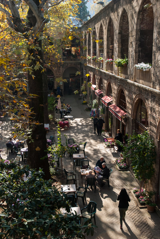
Silk Caravanserai, Bursa, Bursa Province, Turkey
I start my exploration of the city in the busy central bazaar area, centred around the late fourteenth century Grand Mosque, an example of early, Seljuk-influenced Ottoman architecture. Inside the mosque is a central ablutions fountain illuminated by a large ocular skylight; a pleasant change from the usual artificial lighting. The mosque is however more than just a place of worship, forming part of a külliye, a typically Ottoman institution which includes school, hospital, kitchen and communal baths into a single religious and charitable complex. One might at first imagine that the nomadic Turkish tribes raiding and laying siege to the fringes of Byzantium would have been a group of half-savage horsemen, but this is clearly completely at odds with the glorious works of civil architecture which they soon erected in their capital and the speed with which they synthesised elements of civilised Byzantine culture. Not far from the mosque are several arcaded shopping centres and khans (caravanserais), my favourite being the Koza (silk) Khan whose open courtyard, once a medieval marketplace is now a wonderful café where one can sit amidst tall çinar (plane) trees and take respite from the busy streets of the bazaar. On the upper floor, in small, cell-like chambers which would once have housed travelling merchants, real businesses remain; traders and insurance agents; small, smoke-filled offices with suited men, sipping tea from tulip glasses and thumbing tespih (rosary beads) under yellowing portraits of Atatürk.
Away from the immediate bazaar area are several more mosques, tombs and külliye which seem popular with visitors from across the Islamic World, though nowhere does Bursa fell like a tourist trap. Walking up steep streets in the southern part of the city centre, I see the beautiful, green mountains on whose flanks the city has been established and finish the day by walking through the district of Tophane, which has many pleasant corners and a clutch of preserved nineteenth century, wood-framed Ottoman town-houses amid the usual twentieth century concrete.

Bosphorus, Istanbul, Istanbul Province, Turkey
I leave Bursa in the morning, driving down to the Sea of Marmara and around the shores of a long inlet, through the city of İzmit which was devastated by an earthquake in 1999 and onto the D100, Turkey’s main east-west highway. As the road widens and the traffic thickens, I am drawn through concrete satellite towns into the outskirts of Istanbul, one of the world’s largest and in my opinion also finest cities. I park the car beneath an apartment complex belonging to a friend-of-a-friend and continue by metro, crossing first the Bosphorus into Europe (back for the first time since crossing the Ural River in Kazakhstan five months ago), then the Golden Horn, into the district of Fatih, the historic heart of the city where I have hired a hotel room for five nights. In the evening, I am joined by Lia with whom I had spent two weeks in Georgia, back in August.
We are based in the neighbourhood of Sultanahmet, in the very heart of the historical Istanbul where in around 660 BCE Greek settlers from Megara founded the city, then known as Byzantion (Byzantium). It’s just a hundred metres from the hotel to the sea shore and here one starts to appreciate the city’s location; astride the narrow strait which separates Europe from Asia and is the only access route to the Black Sea. No matter the man-made wonders of Istanbul, one is always drawn to the gleaming waters of the Bosphorus which, even in this age of cheap aviation and private cars, still teems with passenger ferries as well as container ships, tankers and fishing boats. This strategic location is the basis of the city’s success, controlling the flow of people and goods between Europe and Asia; a location which made it the continuous capital of an empire for very nearly sixteen centuries.
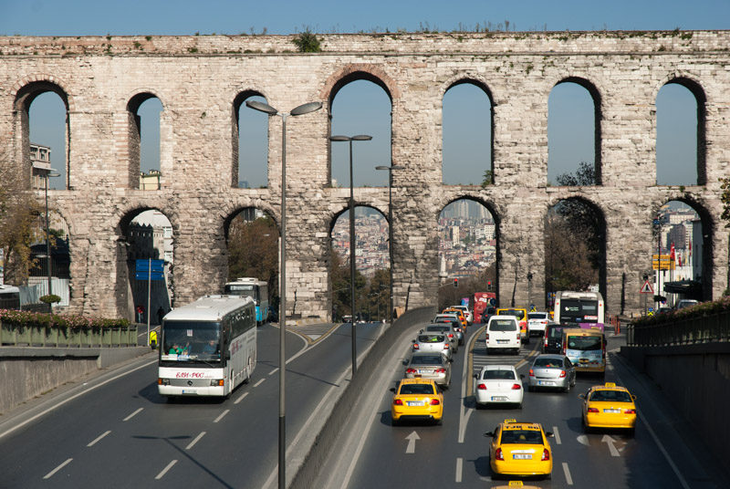
Valens Aqueduct, Istanbul, Istanbul Province, Turkey
As the Roman Empire went into terminal instability and decline across Europe, the Emperor Constantine emerged as its sole ruler in 324 CE and moved the capital to Byzantium in 330, which became known as Constantinople. Thus started the shift from Rome (where the Western Roman Empire would collapse in the fifth century) to the east. Constantine legalised Christianity and built up Constantinople into the great city which it continues to be. This old heart of Istanbul, now known as the district of Fatih, corresponds to the old walled city and we begin by walking a route following the ancient Sea Wall along the Propontis (Sea of Marmara), rounding the promontory which separates the Bosphorus from the Golden Horn, below the ancient hill of Sarayburnu (Seraglio Point) where the first Greek settlers founded the city and where the Topkapı Palace now stands, for centuries home of the Ottoman Sultans. Around here the walls give out, lost below centuries of construction and reconstruction and we reach the waterfront neighbourhood of Eminönü, the city’s most important ferry dock. Turning inland up Atatürk Avenue, we climb and pass one of the city’s greatest secular Byzantine landmarks, the Valens Aqueduct, built in the fourth century to supply Constantinople with water and through whose arches the endless traffic of modern Istanbul still passes.

Skyline, Istanbul, Istanbul Province, Turkey
Heading roughly north, we pass the beautiful Ottoman-era Fatih Mosque, with its türbe (mausoleum) of Sultan Mehmed II, founder of Ottoman Istanbul. We wander through the adjacent bazaar and descend steeply downhill through the traditionally Jewish neighbourhood of Balat, where there is far less traffic and where children kick footballs in the narrow, cobblestone streets which seem to be in the perpetual shade of overhanging pastel-coloured buildings. We’re soon back at the Golden Horn and pick up the city walls once more; this time the Wall of Blachernae which still carry the Byzantine name of this district. Today it’s a rather run-down area which still has the occasional wooden Ottoman-era house, often derelict with boarded windows, remnants of the twentieth century decay of the great empire. We emerge from the walls at Eğri Gate and find ourselves on the edge of ancient Constantinople, walking through a quiet park at the base of the Theodosian Walls. These defensive walls were built in the late fourth century in the time of Emperor Theodosius who made Christianity the state religion of the Byzantine Empire and Constantinople the most important city in Christendom. We climb the walls for a fantastic view across the city; over the roofs of the streets we have just walked through, across the Golden Horn to the district of Beyoğlu and up the Bosphorus to the skyscrapers of Levent, Istanbul’s modern business district. Finally we re-enter Constantinople through Edirne Gate and make our way back to the hotel.

Eminönü, Istanbul, Istanbul Province, Turkey
The next day, we set out to look at Istanbul’s Ottoman endowments which, after the Bosphorus, are surely the city’s most distinctive feature. After the Byzantine Empire reached its zenith in around the sixth century, when it controlled much of southern Europe, the Levant and North Africa, it experienced cycles of decline and recovery; weakened by war with Sassanid Persia, invasions by the Arabs and the loss of much of Anatolia to the Seljuk Turks. After a recovery in the twelfth century, Constantinople was plundered and temporarily occupied by Venetian-led Catholic crusaders from Western Europe, which led to terminal fragmentation and decline. As the newly emerged Ottomans established themselves in the fourteenth century, they conquered Byzantine territory in Anatolia and the Balkans, surrounding the by now ailing and depopulated capital. Finally, in 1453, under Sultan Mehmed II, ‘The Conqueror’, the Ottomans took the city, bringing to an end the Byzantine Empire, and swiftly began to build Constantinople up into a magnificent imperial capital once again; a new centre of the Islamic world.

Dolmabahçe Mosque, Istanbul, Istanbul Province, Turkey
We walk up through the old streets of Sultanahmet to one of Constantinople’s oldest thoroughfares, now the tram line running down to the Golden Horn, where the rather battered remains of the Column of Constantine mark the site where the city was founded almost 1700 years ago. Nearby is the mosque of Gazi Atik Ali Pasha, dating from the reign of Sultan Beyazid II, son of Mehmed the Conqueror and behind that, the entrance to Istanbul’s ancient bazaar. We walk past ancient khans on streets worn smooth by the passage of feet but almost empty on a Sunday, up to the Third Hill on which is located Istanbul’s largest and most impressive Ottoman Mosque. Built by the legendary architect Mimar Sinan, a Janissary (Christian slave conscript) of most likely Armenian descent, the Süleymaniye Mosque is a külliye built for Sultan Suleiman, a stunningly intricate structure with four piercing minarets, distinct from, but clearly owing many architectural elements to the Byzantine Hagia Sophia. Known as ‘The Magnificent’ or ‘The Law-Giver’, Suleiman oversaw the expansion of the Ottoman Empire to its greatest extent; from Hungary to Persia and south to Egypt and the Hejaz, and forged a truly multicultural empire, welcoming Christians and Jews as well as Muslims to settle in his illustrious capital.
We walk back towards Sultanahmet in order to make a comparison with the Sultan Ahmed Mosque, which is of very similar design, having been built by a pupil of Sinan; slightly smaller, but with a more decorative interior. Facing the Hagia Sophia, the Sultan Ahmed Mosque was built for Sultan Ahmed II, who oversaw an Ottoman Empire which struggled to keep its new dominions and had reduced in size since the time of Suleiman. He is also notable for having eliminated the repugnant practice of fratricide within the royal family, though this reform would open the doors to shorter, more contested reigns of future sultans, which ultimately compromised the strength of the empire.

Istiklal Avenue, Istanbul, Istanbul Province, Turkey
Crossing the Golden Horn, we leave old Constantinople, coming to the more modern district of Beşiktaş. Walking along Chamber of Deputies Avenue, planted with beautiful mature plane trees between which are strung large Turkish flags, which flutter above relentless traffic, one comes across the Dolmabahçe Palace and Mosque. The seventeenth and early eighteenth century seem to have been a time of relative stability for the Ottomans, but by the end of the eighteenth century, cracks were starting to appear. The empire, once made strong by expansionism and an unbeatable military, was falling behind more modern European empires. A time of reforms was ushered in, known as Tanzimat and the Dolmabahçe Palace was a move away from the old ways. Built by an Armenian architect, the style is recognisably Ottoman but with clear contemporary European touches of Baroque and Rococo. The project was however ruinously expensive and contributed to the near bankruptcy of an empire which by the late nineteenth century had become riddled with corruption. Siding with the losing powers in World War I, the Ottoman Empire came to an end with the indignity of division between European powers, the disgrace of widespread ethnic cleansing and the total dissolution of the dynasty by Atatürk upon the founding of the Turkish Republic.
Walking inland from the palace, we enter some of Istanbul’s most upmarket areas in Beşiktaş and Şişli, with streets of boutique shops and expensive imported cars. The streets narrow and steepen as one moves westwards, back into Beyoğlu where we eventually reach the huge expanse of Taksim Square, the heart of modern Istanbul. We turn onto İstiklal Avenue which runs back down towards the Golden Horn and is thronging with strolling families, couples and groups of youths. These are the generations enjoying Turkey’s twenty-first century prosperity, removed from the decay and humiliation of the fallen Ottoman Empire, the turmoil of the twentieth century and, perhaps, the hüzün (melancholy) which Orhan Pamuk describes as being innate to the city’s population in his seductively melancholic, semi-autobiographical novel, Istanbul: Memories and the city.
Fatih Sultan Mehmet Bridge, Istanbul, Istanbul Province, Turkey
On our third day in Istanbul, we take a tour of the Bosphorus, a trip peddled by almost every tout in the city, but which is genuinely enjoyable and gives an impression of Istanbul’s setting which one cannot get from walking around the disjointed districts. We set off in the morning from Eminönü onto a Bosphorus buzzing with ferries packed with Monday-morning commuters; only in Bangladesh have I seen busier ferry traffic. It’s a real pleasure to sit back and watch Istanbul pass; the waterfront of Beyoğlu, crowned with the conical-roofed Genoese Galata Tower; the ferry port of Karaköy; the late-Ottoman style Cihangir Mosque; the Dolmabahçe Mosque and waterfront Palace, a tremendously elegant building which can only really be appreciated from the water. Then comes the Neo-Baroque and Ottoman fusion of the small but very fine Ortaköy Mosque, whose white stone exterior gleams in the morning sun which has come out, now that we’ve left the pall of smog hanging over the city centre. The mosque is however now dwarfed by the nearby Bosphorus Bridge, the first bridge to link the European and Asian sides of Istanbul, which opened in 1973.

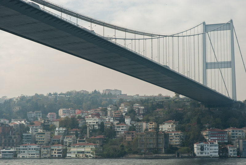
New Mosque, Istanbul, Istanbul Province, Turkey
Beyond the first bridge the European shore becomes less densely populated but is dotted with beautiful yalıs; waterfront mansions dating to the Ottoman-era, owned by rich families as a getaway from their urban konak homes. Next is the fortress of Rumelihisarı, the ‘Strait Cutter’ castle built by Mehmed The Conqueror at great speed in 1452. Together with the older Anadoluhisarı on the opposite, Asian shore of the Bosphorus, the fortress created a vital pinch-point to cut-off all supplies to helpless Constantinople, which had long been surrounded by Ottoman territory. We pass under the Fatih Sultan Mehmet Bridge, the second to cross the Bosphorus, which opened in 1988, then cruise along the shore to the dock at Sarıyer, which looks as if it were a quiet village until relatively recently. Crossing towards the Asian shore, we leave metropolitan Istanbul and are deposited in the fishing village of Anadolu Kavağı; an attractive clutch of waterfront homes set under a promontory. Walking up to the head of the promontory, one finds the Ottoman Yoros Castle, long fought over by the Byzantines, Ottomans and Genoese and which commands a fantastic view towards the entrance to the Black Sea where a steady stream of container ships and tankers are heading towards the ports of Bulgaria, Romania, Ukraine, Russia, Georgia and northern Turkey. Back on the ferry, the return journey takes the same route, this time in the lengthening late afternoon sun, and as we near the Golden Horn we are treated to a heart-stopping view of Istanbul’s unmistakable skyline; low-rise buildings spread across the soft European hills, dotted with the needle-like minarets of the imperial Ottoman mosques. As the sun lowers itself behind the New Mosque in Eminönü, conceived by the scheming wife of Sultan Murad III with the intention of diluting the predominantly Jewish population of the surrounding neighbourhood, we are presented with an almost impossibly romantic view, and I am left with little doubt that Istanbul has the finest skyline of any city.

Haydarpaşa Station, Istanbul, Istanbul Province, Turkey
Each time I am in Istanbul I feel drawn to the Bosphorus and find myself taking ferries across it with no specific destination in mind. Thus in the evening, despite having spent most of the day on ferries, we take another across to the dock at Kadıköy on the Asian shore. We decide to walk north to the beautiful imperial railway station at Haydarpaşa which was built by German architects at the start of the twentieth century as terminus of the Hejaz and later Baghdad Railways, at a time when both were part of the Ottoman Empire. With echoes of a German schloss, the station is a distinctive landmark on the city’s Asian shore, but alas all train services to Haydarpaşa were suspended last year as part of the modernisation of Istanbul’s transport system. Here, I find myself feeling my own sense of Istanbulite hüzün; for the now silent platforms of the station, with its fallen imperial grandeur; for the cessation of long overland rail services; for the fact that both Mecca and Baghdad are practically inaccessible these days, but most of all for the intense nostalgia which overcomes me at revisiting the place where, as an inexperienced youth, I set off on the sweaty evening of the 26th June 2003 aboard the Fatih Expressi to Ankara, thus beginning a life-changing journey across Asia.
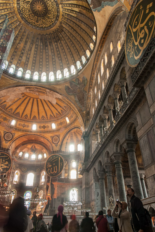
Hagia Sophia, Istanbul, Istanbul Province, Turkey
On our fourth and final day, we focus on the attractions in the very heart of old Constantinople, which is dominated of course by the Hagia Sophia. Built in 537 CE, it was the showpiece of the Byzantine Empire and an unprecedented architectural achievement, remaining the world’s largest cathedral for very nearly a thousand years. The Hagia Sophia, or ‘Wisdom of God’ was the standard-setter of Byzantine architecture and has influenced thousands of churches which have come after it. From the exterior, the numerous reinforcements made over the years following damage by earthquakes and the addition of four incongruous Ottoman-era minarets rob the structure of some of its grace, and the building, now a secular museum, crawls with tourists, but the interior remains breathtaking. One enters from the old Imperial Gate, which in the past only the Byzantine Emperors, God’s representatives on Earth, could have used. In the tympanum of the entrance is one of many beautiful mosaics, showing Christ Pantocrator, the eternal, omnipotent judge of humanity, with a prostrating emperor at his feet. Other figurative mosaics inside, restored from their cover of plaster from Muslim Ottomans, represent some of the finest examples of Byzantine post-iconoclastic art. The internal space has been added to many times over the years, including conversion to a mosque, which gives it an unintended eclecticism, but one cannot fail to imagine the awestruck visitors entering the church in Byzantine times, when Hagia Sophia was the eye of the world, the very heart of Christendom. One such group would have been the envoys of Prince Vladimir in Kyiv, who were dumbstruck by the Hagia Sophia’s grandeur and brought back the Byzantine rite which led to the conversion of Pagan Rus’ in 989. When, in 1453 Mehmed The Conqueror entered the Hagia Sophia (after defeating and beheading the childless last emperor of Byzantium, Constantine XI), he ordered its immediate conversion to a mosque, thus ensuring that the building remained an active centre of worship.

Comnenus Mosaic, Hagia Sophia, Istanbul, Istanbul Province, Turkey
Next, we walk to Istanbul’s famed bazaar, which must have been the focus of activity for even longer than the Hagia Sophia. Here however, I reach my saturation-point of the herds of dawdling tourists; it is clear that the beautiful covered bazaar is no longer part of living Istanbul but an emporium only for the selling of trinkets to tourists and I leave quickly. There is nothing of the real civic ambiance of the great bazaars of Iran. Similarly, walking through the gardens of the Topkapı Palace, famed for the imperial Harem designed to produce many dynastic offspring in the fratricidal society of the sultans, I balk at the tourist hordes waiting to shuffle through the palace. In the evening we stroll in what once was the Hippodrome and is now a square of the same name, marked by two obelisks; one of Ancient Egyptian origin and the other, slightly cruder, Byzantine. The view here, looking across a small park to a side view of the Sultan Ahmed Mosque was among my first, and lasting view of Istanbul in 2003. I feel that on this trip, I’ve seen far more of the city’s great depth of history, but in such a multifaceted metropolis I am very aware that this is a somewhat superficial view, and fully expect to make further journeys in future to this amazing, enchanting, timeless city.

Edirne, Edirne Province, Turkey
Lia flies out in the morning and in the afternoon I cross back to the Asian side to retrieve the truck and drive to the car ferry at Harem in the Asian district of Üsküdar. As I cross the Bosphorus one final time, the sun dips behind grey clouds, reflecting my mood with the upcoming return to dismal Western Europe. Landing at Sirkeci at the foot of the Topkapı Palace is one final romantic vision before I join the frantic traffic. Istanbul’s ugly modern suburbs sprawl for many kilometres, but by late afternoon I’m driving through the undulating fields of Thrace, towards the second Ottoman capital, Edirne. Known to the Byzantines as Adrianople, Edirne was in Ottoman hands long before Constantinople, as the empire moved west from Bursa across the Dardanelles and into Balkan Europe. I’m hosted in Edirne by Gökhan, an ebullient, charismatic student and ardent womaniser who seems to spend far more time luring his female classmates to his apartment than any form of studying, but is a very entertaining host in this grey corner of Europe. I would saddened to hear, eighteen months later, that Gökhan died of a heart attack, aged just 26.
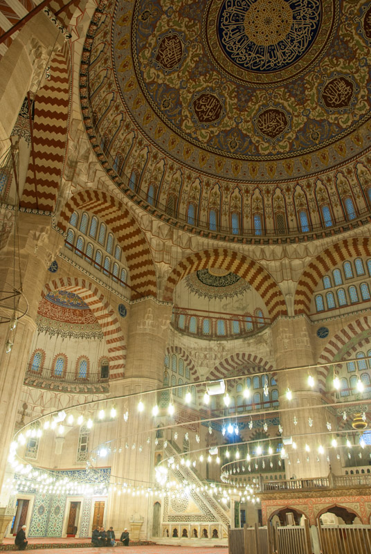
Selimiye Mosque, Edirne, Edirne Province, Turkey
Edirne would have been a multicultural city in Ottoman times and today it remains somewhat so, though it now suffers as a border city, choked with lorry traffic and visited more by Bulgarian and Greek shoppers than tourists. Edirne’s centre reminds me already of Eastern Europe with pastel-painted houses, the Grand Synagogue of a mostly departed Jewish population and a general air of fallen empire; a backwater compared to Istanbul. To the west of the centre is the beautiful Gazi Mihail Bridge and külliye but instead of being at the heart of civic life as elsewhere, here the fine mosque is surrounded by a few village houses and muddy, bare fields.
All this however pales in comparison to Edirne’s centrepiece; the Selimiye Mosque, built in the time of the rather inglorious Sultan Selim II. This mosque was Mimar Sinan’s masterpiece, from the ‘Master Stage’ of his long career; larger and more graceful even than the Süleymaniye Mosque of Istanbul. Without a prominent hill-top setting, the mosque’s size is deceptive from the exterior, but the interior is truly staggering. With no tourists around, I sit on the carpet of the mosque and am humbled by the huge, pillar-less internal space, which reduces a human figure to insignificance. The Selimiye Mosque is one of the great achievements of Islamic architecture and I spend quite some time silently admiring it, filled with a touch of the awe that I first felt in the beautiful mosques of Iran, on that first trip across Asia which started just down the road in Istanbul.
I have a rest day in Edirne before saying farewell to Gökhan and driving the last twenty kilometres to the Bulgarian border, where I make an unceremonious exit from Turkey.
I return via Bulgaria, a country which surprises me with its beauty and which looks far more like parts of the Former USSR than any other of the Eastern Bloc countries, and where I stay for a night in Sofia with Ivailo, a Bulgarian I had met two months earlier in Yerevan. Then it’s north across the Danube to the quite shocking desolation of western Romania and into Hungary where the bland, over-regulation of the EU starts to show. I break the journey home with stops in Munich, Homburg and Leuven, finally crossing the Channel and returning to my childhood home in Kent on the 23rd November 2014, more than five-and-a-half months after departing, having covered 33,371 kilometres.
Stage 40 – Turkey: Mesopotamia To Thrace [1/2]
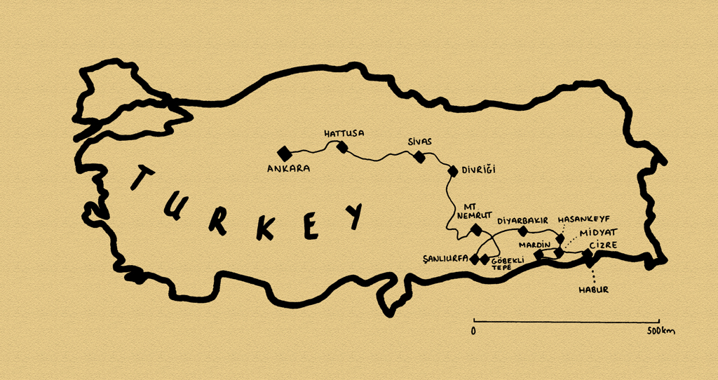
The final stage of my five-and-a-half month 2014 journey would take me diagonally across Turkey on a journey of more than three thousand kilometres, from the Iraqi border to the edge of the EU. Having only previously explored the predominantly Kurdish Armenian Highlands of the country’s east, I would now embark across several distinct regions of the country. The first part of this stage would take me from the hazy plains of Upper Mesopotamia, with their remnant population of Assyrians and Arabs through the tense, unofficial Kurdish capital of Diyarbakır then turn north into the rolling mountain landscape of Anatolia. Here I would see what strikes me as the Turkish heartland and glimpse layers of history from the most ancient Anatolians; the Hittites who centred their empire in Hattusa; the Eastern Roman buffer state of Commagene and the glorious architecture of the Seljuks, ancestors of modern-day Turks, before stopping in the Turkish capital, Ankara.

Grand Mosque, Cizre, Şırnak Province, Turkey
It’s well after dark on the 23rd October 2014 as I cross the Habur River into Turkey, quickly passing through customs and arriving in the city of Cizre, located on the Tigris alongside the Syrian border, a little more than an hour later. Cizre is an ancient city, historically the gateway between the mountains of Armenia and the plains of Upper Mesopotamia. It is regarded in the Islamic tradition as the city founded by Noah at the foot of Mount Juda, where the Ark came to rest. Until the twentieth century Cizre would have been a polyglot city, located in the Assyrian Heartland with populations of Assyrians and Armenians. However, the Armenian and Assyrian Genocides of 1915 decimated these populations and has left the population predominantly Kurdish. The Kurds also have their grievances with the repressive Turkish State and there is a palpable air of tension in Cizre. Earlier in the month, riots broke out which saw at least thirty-five Kurds killed by Turkish security forces and as I stop in the city’s main street, I notice an abundance of Cobra infantry carriers belonging to the Jendarma, the Turkish paramilitary security and law enforcement force.
I’m hosted in Cizre by Şeyhmus, a local English teacher. We meet in the city centre and have some tea in a university chaikhana (tea house) before retiring to the family home, which sits away from the street in a gated courtyard, away from the eyes of the Jendarma. Early next morning, Şeyhmus and I visit Cizre’s twelfth century Grand Mosque, a rather squat building made of ancient stones but topped by a distinctive, tapering and slightly crooked brick minaret, reminiscent of a Mesopotamian ziggurat. We then proceed to Şeyhmus’ school where, after meeting numerous classes of excitable Kurdish children, and breakfast with his fellow teachers, I say goodbye and begin my journey westwards.
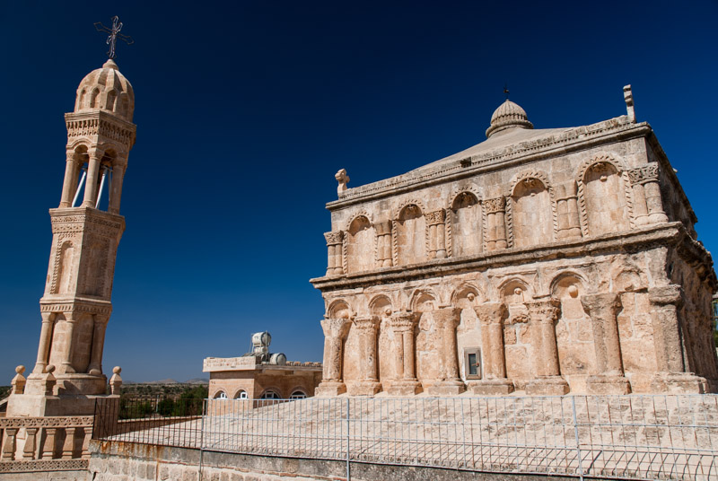
Mother Of God Church, Anıtlı, Mardin Province, Turkey
The road climbs briefly out of Cizre, tracking the edge of the Mesopotamian Plain onto an upland area known in the local Syriac language as Tur Abdin; a rocky, scrubby landscape dotted by Assyrian villages of attractive yellow limestone houses. Although the Assyrian population was decimated by the genocide of 1915, it was in Tur Abdin that the Assyrians put up a successful resistance to the bands of Kurdish irregulars armed by the Ottomans and sent to murder and expel Christians from Ottoman territory. This is therefore the only region of Turkey where Assyrians continue to live in their ancestral homeland, though they remain the subject of government harassment. I stop at the Mor Gabriel Monastery, established in the late fourth century BCE making it the oldest Syriac Orthodox Monastery in the world. Still active, Mor Gabriel has weathered the Mongols, Tamerlane and Ottomans and remains a delightfully tranquil sanctuary in this troubled region.
Old City, Midyat, Mardin Province, Turkey
It’s a perfect autumn day and a real pleasure to drive through the quiet villages of Tur Abdin. I stop first in Anıtlı (known as Hah in Syriac), a village of fortified stone houses with the gorgeously carved, fifth century Mother of God Church. Nearby İzbırak (Zaz in Syriac) presents an imposing view over the plains of ancient-looking yellow stone buildings etched against the piercing, cloudless blue sky. Sadly though, on closer inspection, one can see that much of the village is abandoned, its population having withered during the course of the twentieth century.
The city of Midyat marks roughly the western extent of the Assyrian villages of Tur Abdin and I spend the afternoon exploring the winding back-streets of the Old City, elegantly built from local yellow limestone and dotted with old churches and fine houses, though some show signs of neglect, most likely due to their owners having emigrated. It is nevertheless a clear change from the Kurdish east of the country where settlements are almost invariably shabby, charmless and sometimes rather squalid.

Şehidiye Madrasa, Mardin, Mardin Province, Turkey
My destination for the day is the city of Mardin which I reach in the evening. Famed for its beautiful yellow limestone houses which spread picturesquely up a steep hillside, Mardin attracts domestic and international tourists and has something of a modern, dynamic air. I’m hosted here by Erbil, a Turk from the west who works as an engineer for the Turkish Army and lives in a small, cavernous house in the heart of the Old City. Mardin in some respects looks a little like Midyat and has a number of churches, but it is the Islamic architecture of the city which is most striking. As the final capital of the Artukid Dynasty, one of a number of Turkic dynasties who arrived from Central Asia and began the Turkification of Byzantine Anatolia, Mardin was richly endowed with fine medieval architecture. I spend an entire day walking through the narrow and atmospheric alleyways and back-streets, encountering several of these magnificent edifices such as the fourteenth century Şehidiye Madrasa (seminary), whose minaret soars above the city’s rooftops, overlooking the hazy fields of the Mesopotamian Plains. Others include the imposing Zinçiriye Madrasa, another fourteenth century Islamic seminary with a magnificently carved portal and fluted, segmented dome. The twelfth century Grand Mosque, one of the oldest in Anatolia, is marked by its square-based minaret of finely carved local yellow stone, which overlooks the narrow lanes of the bazaar, beautifully scented by the fragrances of Mardin’s famous hand-made soaps. Mardin quickly becomes perhaps my favourite small city in Turkey.

El Rizk Mosque, Hasankeyf, Batman Province, Turkey
I leave Mardin the following morning, heading south onto the plains of Mesopotamia, passing the fifth-century Mor Hananyo Monastery, seat of the Syriac Orthodox Church from the twelfth century until 1933. The view back to Mardin’s steep streets soon recedes as I head towards the Syrian border, stopping at the ruins of Dara. Dara was a fortress of the Byzantine Empire situated on its eastern border with Sassanid Persia and site of the Battle of Dara in 530. Today the site is in ruins, but an intriguing cave-necropolis remains, as do several water cisterns, though the tranquillity of the site is rather ruined by persistent begging of a pack of Kurdish urchins from the nearby village.
Joining the highway from Dara, I am driving exactly along the Syrian border; in places the barbed wire fence is just metres from the road. Beyond is a country of which I have very fond memories of visiting in 2006, though which is presently embroiled in a brutal civil war. In Nusaybin I head north, climbing back onto the Tur Abdin Plateau, passing through Midyat once more and descending to the Tigris River in the poignantly beautiful town of Hasankeyf. The legendary Tigris, which flows down to the fertile plains of Iraq and nurtured the origins of human civilisation, has carved steep cliffs in which caves were carved by Hasankeyf’s earliest inhabitants. Today the archaeological site is off-limits for ‘safety’ reasons, but amongst the scruffy buildings of the modern town are more endowments from the Artukids, who made Hasankeyf their first capital, such as the El Rizk Mosque with its ornately carved minaret, now topped by a stork’s nest. The valley below is very picturesque, with the turquoise Tigris watering stands of green trees in a powdery-grey, dry landscape; a scene which reminds me of the valleys of northern Pakistan or Afghanistan but one which sadly will soon disappear, to be flooded by the Ilısu Dam sometime in the next few years.

Kurdish Man, Diyarbakır, Diyarbakır Province, Turkey
From Hasankeyf I roughly follow the Tigris west through Batman, passing working pumpjacks and fields of ripe cotton to Diyarbakır. Considered the unofficial Kurdish capital of Turkey, I first passed through Diyarbakır in 2003 on my first overland journey across Asia and remember being driven around a hot, shambolic city by an Air Force pilot whom I had met at the bus station. Today, I arrive in the western suburbs of a vibrant, buzzing city very different from that which I remember. I meet my host Ferhat, a Kurdish logistics manager recently returned from working in Istanbul and Antalya in the west of the country, who proceeds to show me his home city. We eat the best lahmacun (a ubiquitous Turkish type of pizza) I would ever taste in Turkey, then move on to have coffee in a café filled with a young, intellectual-looking crowd. After this, we move into the Old City, which is heavily policed by the Jendarma in infantry carriers, water cannons and assault vehicles. There’s a palpable sense of tension in the air and as we walk through the bazaar; trade has wound down for the day, but we watch a mob starting to form around a thief, filling the streets with shouts and crowds of onlookers. Ferhat takes me to the beautifully restored, black basalt Deliller Khan (caravanserai), an ancient traders’ inn now converted into an allegedly Armenian-owned hotel and restaurant, where we sip a good red wine made by local Assyrians; a pleasing sign of latent cosmopolitanism in this ethnically cleansed land. Inside is a well heeled crowd, many couples and groups of women who Ferhat tells me are most likely students from the west of Turkey. On our way back to the truck, we pass through the Old City walls and my eyes start to sting slightly. Ferhat soon sniffs and tells me there is tear-gas in the air: something is going on, and two youths coming from the opposite direction confirm there is some trouble, and that police have barricaded the streets. By the time we reach Ferhat’s Mother’s smart new apartment on the western edge of the city, I’m deeply impressed by the contrasts I have seen in just one evening in Diyarbakır.

City Walls, Diyarbakır, Diyarbakır Province, Turkey
I spend the whole of the following day with Ferhat exploring Diyarbakır, which feels slightly calmer in daylight. I’m drawn to the Old City, which is surrounded by imposing black basalt walls several kilometres in length and largely intact, making Diyarbakır a rare example of a preserved, walled medieval city. In a central street, lined by khans and ancient shopping arcades, is a central square where men sit at small tables drinking tea and playing backgammon. Much of the central city architecture consists of black-white banded architecture reminiscent of Umayyad architecture of the Middle East. The eleventh century Grand Mosque, which sits behind the square, is an eleventh century Seljuk structure executed in black basalt, but incorporates two tiers of arcaded Corinthian columns taken from an earlier Roman theatre during a twelfth century reconstruction, which reminds me somewhat of the Grand Mosque of Damascus.
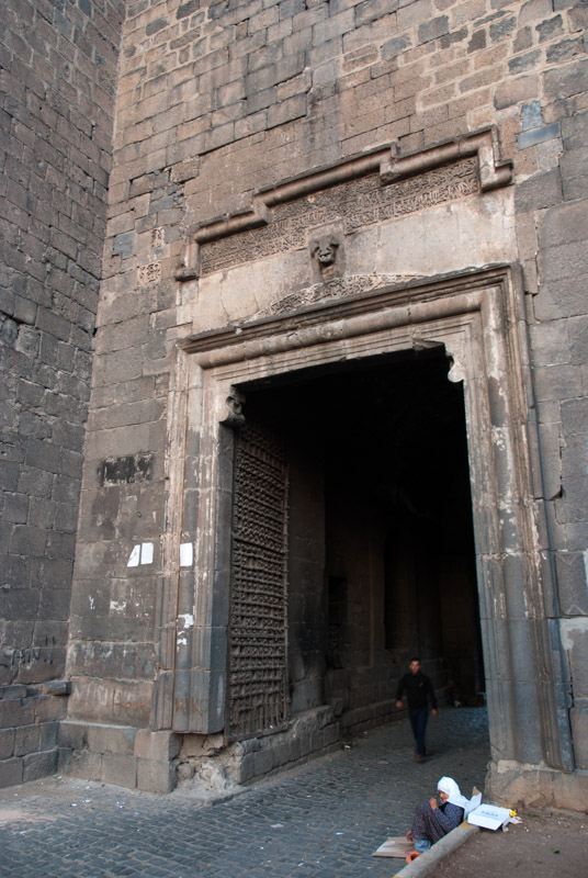
Urfa Gate, Diyarbakır, Diyarbakır Province, Turkey
In the east of the Old City is a small Christian Quarter, and we visit the Assyrian Mor Petyun Church and Armenian St Giragos Church; both made from local black basalt and both having an ever decreasing congregation. In the afternoon we scale the city walls for views across the city and surrounding countryside, but as we walk towards the western edge of the walls we enter a slum area; there are signs of drug use around and when walking in the narrow streets below the walls, I get a sense of not being absolutely safe; something which happens so rarely in Asia I can only remember one similar instance, in Osh, Kyrgyzstan. Diyarbakır is indeed in some ways the centre of the Kurdish insurgency and was off-limits for security reasons during the 1980s. Operations and land expropriations by the Turkish government continue to target these areas in order to counter ‘terrorism’. In the evening, Ferhat and I sit out on his mother’s balcony, watching the light fade over the city. Like all Turkish Kurds, Ferhat is distressed by the treatment of his fellows in Turkey, though like most whom I have met, he does not desire a separate Kurdish state, simply recognition and equality in his home country where, until 1991, Kurds were described officially (and erroneously) as ‘Mountain Turks’ and where it remains illegal to teach Kurdish in any school. Unlike Assyrians and Armenians however, the position of the Kurds must inevitable improve, if for no other reason than force of numbers. Kurds currently make up around a fifth of the Turkish population and have a far higher fertility rate than Turks; as is perhaps well demonstrated by the sea of new apartment buildings in this affluent suburb of Diyarbakır.

Megaliths, Göbekli Tepe, Şanlıurfa Province, Turkey
Leaving the Tigris Valley, I continue my westward journey to the junction town of Siverek and south, back to the fringes of Mesopotamia, towards the city of Şanlıurfa. I stop short however to visit one of the world’s most intriguing archaeological sites: Göbekli Tepe. Located on a prominent hill, Göbekli Tepe dates back to the Pre-Pottery Neolithic period, from which time there are numerous sites across the Levant and Upper Mesopotamia. What makes Göbekli Tepe special however is the unearthing of what appears some kind of temple, used for social and ritual activities, dating to the tenth or ninth century BCE, greatly predating the cities of Lower Mesopotamia. Göbekli Tepe therefore challenges the dogma that the construction of monumental complexes would only be possible by civilised, settled societies and not the presumably hunter-gatherers who must have constructed the site. The main excavations consist of five circular pits, seemingly randomly arranged, each with T-shaped megaliths set radially around the pit edge. Many of the megaliths bear reliefs of animals, more finely carved than the rock art which typifies the period and the largest, which stand around five metres tall, show what looks to be a highly stylised human figure. The arrangement of stone circles reminds me of other megalithic temples but the carvings are unprecedented and fascinating. The meaning of the carvings, the precise function of the site and the means by which an apparently unsettled society made such a complex are a mystery. There are numerous un-excavated sites nearby which appear to have similar T-shaped megaliths, which makes one wonder how many more, potentially older, Göbekli Tepes there might be.

Bazaar, Şanlıurfa, Şanlıurfa Province, Turkey
I find Göbekli Tepe a deeply thought-provoking, even moving experience. To look back more than ten thousand years to what is perhaps one of humanity’s earliest complex constructions makes one think how young human civilisation really is, and that despite the gruesome recent history and troubled present seemingly driven by barbaric nationalism, humanity has progressed hugely in what is, relatively, a very short period of time.
I make my way into Şanlıurfa, known simply as Urfa, later in the afternoon and join my hosts, brothers Emin and Mustafa, two Arab Turks who hail from very close to the Syrian border. Urfa is an ancient city, officially founded by the Seleucids, who named it Edessa, but perhaps far older. Emin and Mustafa take me on a tour of Urfa in the evening, around the busy streets and to the holy shrine known as Abraham’s Pool. Urfa is one (somewhat unlikely) candidate for the Biblical city of Ur of the Chaldees, birthplace of Abraham, and local tradition has it that King Nimrod immolated Abraham here on a funeral pyre, only for it to be turned by God into water, with the coals becoming fish in what is now known as Abraham’s Pool. On the way back home we pick up a künefe, an originally Arabian, rich cheese pastry soaked in syrup and served hot, which makes a nice end to a great day.
I spend the whole of the following day walking around Urfa. The city has a strong Middle Eastern flavour, with many Turkish Arabs and Arab visitors, but it is undoubtedly Turkish. I particularly enjoy the rich bazaars which remind me further of the Levant, narrow, labyrinthine streets and attractive urban architecture of arcaded shops and two-storey caravanserais built from white stone.
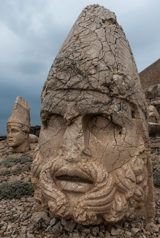
Heads of Hercules and Apollo, Mount Nemrut, Adıyaman Province, Turkey
Urfa is my last stop in Mesopotamia and I leave the city on a rainy morning, heading north and closing a loop back to Siverek, then quickly west to catch a ferry across the Euphrates, passing by a new bridge which is just a few metres short of completion. On the right bank of the Euphrates I am immediately in the Taurus Mountains, under the slopes of Mount Nemrut, on the summit of which one finds one of Turkey’s most iconic sites. This region was once part of the Kingdom of Commagene, a small state which emerged from the disintegrating Seleucid Empire and lay on the border of Hellenistic and Persian civilisations, itself a mixture of Greek, Armenian and Persian influences. The most famous king of Commagene, Antiochus I Theos, built a mountain-top sanctuary here in 62 BCE consisting of a pantheon of huge, seated gods (including himself) from the syncretic religion of Commagene.
Back in 2003 I had wanted to visit Mount Nemrut, but being without my own transport and failing to find any other travellers in the fly-blown town of Kâhta with which to split the cost of a tour to the summit, I left disappointed. Today the weather is bad, but I fulfil this frustrated ambition from eleven years ago, driving myself up a paved road to a large car park at around two thousand metres elevation. It’s out of season and I have the site almost to myself, which certainly makes up for the overcast weather. After a short walk, one reaches the ruins of King Antiochus’ sanctuary, surrounding a scree-covered summit which is thought to cover his tomb. The statues must have been a stunning sight when complete, but at some point in history unknown iconoclastic zealots have systematically beheaded them, leaving the heads surreally detached on the stony mountain slopes. Nevertheless, the carved features of the heads remain well preserved and show figures representing Greek, Armenian and Persian mythology; Heracles (Hercules), Apollo, Zeus-Oromasdes (a Greek-Armenian hybrid); Persian-style eagles and lions, Tyche, the goddess of Commagene and of course Antiochus I Theos himself.
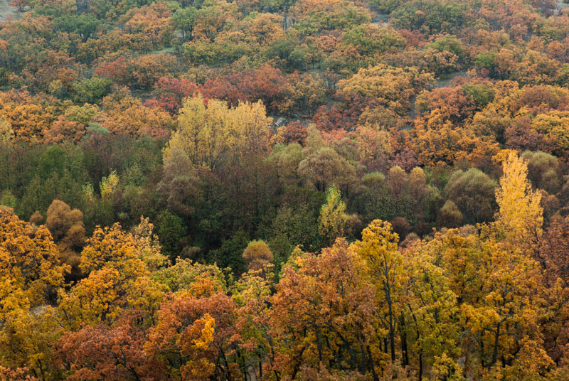
Landscape, Malatya Province, Turkey
I descend the mountain on small roads to the west, stopping at Arsameia, site of a funerary monument to King Mithridates I Callinicus, son of Antiochus I Theos, which contains a stunning relief of Antiochus shaking hands with the god Hercules. I stop again at the Karakuş Tumulus, burial site of female members of the Commagene royal family, from where I get a final glimpse of the Euphrates as darkness falls. I then drive south through Kâhta, which seems far less squalid than I remember it; west, through Adıyaman and round, climbing northwards into the Taurus Mountains on a traffic-choked road, crossing a low pass and driving into the night through persistent rain. I stop finally and sleep in an apricot orchard near the city of Malatya, where I had spent a night in 2003. Continuing north, I spend the morning driving in a ruggedly beautiful, autumnal landscape of mountain valleys on good, quiet roads and at around lunchtime stop in the charming town of Divriği.

Grand Mosque, Divriği, Sivas Province, Turkey
Since leaving the surroundings of Malatya this morning, I have realised that I am seeing yet another side of Turkey; not the Kurdish east or the plains of Mesopotamia, but Anatolia proper, the Turkish heartland. All around are poplar and apricot trees in vivid autumnal yellow and orange. Instead of the squalid villages of the east with their mostly style-less concrete hovels, here are villages of individually-built houses with attractive terracotta tiled roofs. Divriği seems to embody all these changes in character, and I find myself instantly liking the place.
Although founded by heretic Armenians in the ninth century, Divriği is famous for its UNESCO World Heritage-listed Grand Mosque and Darüşşifa (hospital), a thirteenth century complex constructed by the local Mengüjek House of the Seljuk Dynasty, and is among the most beautiful buildings in Anatolia. The portals of both mosque and hospital are densely covered in highly elaborate carvings, an unrestrained riot of artistry which combines geometric designs with huge flowers and even a two-headed bird; certainly the most expressive Islamic sculpture I have seen, though I suspect the mason would have been of Armenian origin. In contrast to the extravagant portals, the rest of the building has the solid, militaristic bulk typical of Seljuk architecture, but somehow the two styles offset each other to great overall effect.

Bazaar, Divriği, Sivas Province, Turkey
As I arrive at the complex, a loud and poetic azan (call to prayer) fills the valley in which the town sits and men, mostly wearing dark blazers, begin to congregate to hear the Friday noon sermon, despite the unrelenting rain. As the men begin to pray, I enter the Darüşşifa which is just as impressive inside as out, with a beautifully vaulted ceiling, carved pillars, a central fountain and cantilevered staircase leading to an upper level separated from the main hall. Despite being relatively newly arrived from the nomadic steppes of Central Asia, it is clear from buildings such as this that the Seljuks were no barbarians and quickly established the infrastructure of civil society. Once the sermon has ended, I move next door into the mosque which has a large open prayer area between huge pillars supporting a finely moulded dome. As the last of the locals file out, I am left in the cool, calming mosque with only the mullah in the corner, kneeling and reading a Quran, deeply in thought.

Seljuk Park, Sivas, Sivas Province, Turkey
Down in the town centre I am further delighted by a compact bazaar with cobblestone streets strung with vines. Despite the pouring rain there is plenty of activity in town, with men standing in doorways and under roof eaves chatting and smoking. Women are also far more prominent than in the towns of the east, usually uncovered, out having tea together in restaurants, driving cars and shopping. Divriği feels to me like my first real Turkish town, here in the mountains of Anatolia.
By mid-afternoon, with the rain still coming down, I leave Divriği and drive north on more beautiful, winding roads to meet one of the country’s main west-east roads and turn west to the regional capital of Sivas. Known to the Romans as Sebasteia, Sivas was a regional capital of the Byzantine Empire, was the first major city to be taken by Turkic tribes arriving from the east and was later incorporated into the Seljuk Sultanate of Rum in 1174, periodically serving as its capital. Later, under the Ottomans, Sivas would lose its historically important position but remains today as a pleasant and unpretentious provincial city well endowed with some of the finest examples of Seljuk architecture. I spend a morning walking around the centre of Sivas in the cold, incessant rain admiring the beautiful medieval madrasas. Particularly pleasing is the city’s central Seljuk Park containing the Çifte Minareli Madrasa with its twin, needle-like minarets; facing this, the extremely fine carvings on the facade of the Şifaiye Madrasa which now operates as a restaurant, and beyond this, the stubby but imposing Buruciye Madrasa with a beautifully carved portal, now a chaikhana. Whilst none of these is quite as fine as Divriği’s Grand Mosque and Hospital, their location in the centre of a modern-day city gives them a wonderful sense of continuity of the original Seljuk civic designs.
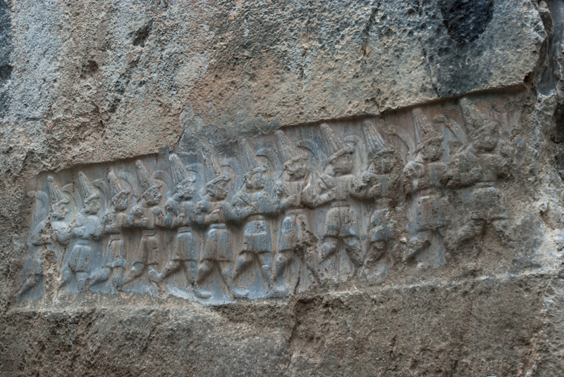
Relief, Yazılıkaya, Çorum Province, Turkey
I leave Sivas in the afternoon, heading west. With now more than thirty six hours of continuous rain and temperatures in single figures at night, the balmy warmth of Mesopotamia seems a long way off. I drive into the night, leaving the main highway in Yozgat and stopping for the night in a field just outside of the village of Boğazkale. Long before the Seljuks or Byzantines, in the second millennium BCE, the Hittites rose from somewhat obscure origins to build the first Anatolian empire; contemporaries (and rivals) of the empires of Assyria and Egypt. The Hittites, speakers of the earliest identifiable Indo-European language, controlled an empire which at its zenith in the mid fourteenth century BCE controlled much of Anatolia, Upper Mesopotamia and the Levant, but rather mysteriously disappeared in approximately 1200 BCE. Boğazkale lies alongside the ruins of Hattusa, the capital of the Hittites, surrounded by a rolling Anatolian landscape of fields, hills and oak forests.
I start the day in the Hittite sanctuary known in Turkish as Yazılıkaya, where in a small rocky canyon at knee-height, two thirteenth century BCE friezes depict processions of deities in distinctive Hittite dress; males deities on one side in short skirts, pointed shoes and tall, horned hats and females on the other in long skirts, wearing crowns. Beyond the friezes are further, better preserved carvings showing twelve gods of the Underworld; an odd, armless representation of the god Nergal from the Babylonian pantheon who is mentioned in the Old Testament, and a carving of the god Sharruma (borrowed from the Hurrian pantheon) and Hittite King Tudhaliya IV who may have been be buried here.

Lion Gate, Hattusa, Çorum Province, Turkey
Down on the valley floor lie the remains of the city of Hattusa itself, with Cyclopean walls enclosing an area of almost two square kilometres, which would have contained numerous temples and a central citadel with the royal residence. There is however little to see beyond foundations, although the city walls, dating from the fourteenth century BCE still retain a number of gates named after the carved figures which guard them. Most impressive however is the thought that with a population of perhaps forty or fifty thousand, Hattusa would once have been one of the world’s largest cities.
Leaving for Ankara, I take a detour through the small town of Alacahöyük, which sits next to an excavated höyük (settlement mound) and has been continually inhabited since the Bronze Age. Besides an impressive Hittite gate very similar to those of Hattusa, the site is notable for a collection of graves of the Hatti, the oldest recorded Anatolian civilisation, cultural forebears of the Hittites who lent their name to Hattusa and left fantastic bronze and gold artefacts with the dead which they buried.
As I drive the final stretch of highway towards Ankara in the evening, I realise that Anatolia is something of a new region of Eurasia to me; one that is very different from the eastern region of Turkey with which I am more familiar, and with its soft, rolling landscape, rich history and attractive villages, is an area I look forward to further exploring.
