
Stage 6 – Iran: Great Iranian Empires [1/2]

Iran is a country of staggering historic depth and a cultural keystone of Western and Central Asia. Lying at a crossroads between historical empires in Europe, Arabia and Central Asia, Iran has been invaded innumerable times but the Iranian nation, today a mix of Persians, Turks and many other minorities has endured, absorbing the bloodlines and ideas of these invaders and exporting their advanced culture through three historical, regional empires.
The fortunes of Iran have waxed and waned over the millennia and since the Iranian Revolution of 1979, when hardline ayatollahs (clerics) overthrew the last shah, finally ending the ancient Iranian dynasties, the country has found itself a pariah state, maligned and subject to punitive sanctions from the American-led international community. In addition to this external pressure, the Iranian people currently endure an authoritarian, regressively theocratic regime whose leaders chase romantic ideals of medieval Islamic piety.
Through ignorance and propaganda, many Westerners have very skewed or plainly incorrect notions of Iranian society and this is perhaps the greatest pain of the deeply troubled Iranian soul. It gives Iranians great joy and reassurance to see foreigners’ stereotypes dissolve as they encounter a modern, sophisticated and overwhelmingly friendly nation with a rich culture, both ancient and (despite the efforts of the ayatollahs) modern. But the Iranian character is a deeply puzzling one and is not easily understood. I would spend nearly one year in the country during the Odyssey over several visits; time I used not just to cover the country’s considerable size, but to gain a little understanding of the complex, often contradictory, or even bipolar persona of the Iranians.
On this first, ten-week long journey around Iran, I would delve deeply into Iranian history, starting with the Islamic period then heading for the south where Iran’s earliest civilisations came to bear. Through the famed Iranian hospitality, I would also find myself invited into various homes, often staying with families for a week or more, in order to start understanding the culture of a people who can trace their customs back more than two-and-a-half millennia.

Khomeini Mural, Mashhad, Razavi Khorasan Province, Iran
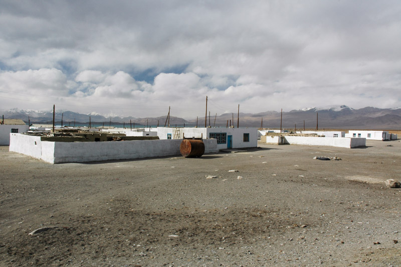
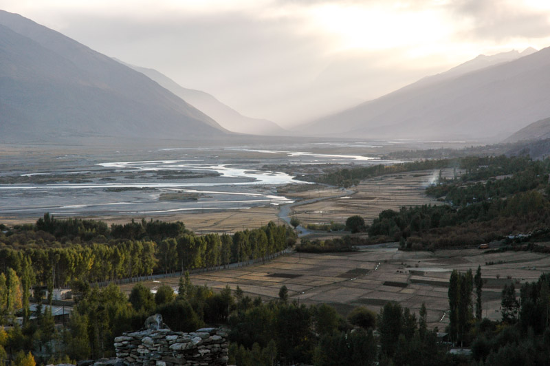
On the 8th November 2007, I cross the Kopet Dag mountains from Turkmenistan and, after exasperating Iranian customs procedures, drive down in the afternoon to the city of Quchan and onto Highway 22, heading east towards Iran’s second largest city, Mashhad. This is my second visit to Iran (the first was in 2003), but my first time driving here and after the generally quiet roads of Central Asia, the level of traffic and standard of driving are shocking. Iran has a horrific road accident death toll and almost every Iranian I have ever asked knows somebody who has been killed in a road traffic accident. The total disregard for road safety would be a continuing source of frustration on every visit to Iran.
I stop well after dark in the teeming city of Mashhad, location of the country’s holiest site, the Holy Shrine of Imam Reza. Islam was brought to Iran by the invading Arabs of the Rashidun Caliphate (immediate successors of the Prophet Muhammad), who took advantage of a Sassanian Empire severely weakened by wars with the Byzantines. Already the schism in Islam had divided the Muslims into majority Sunnis, who believed in hereditary succession of the caliphs and the Shi’ite sect, followers of Muhammad’s cousin Ali, the first of the twelve imams who most Shias believe to be just, exemplary, perfect human beings and rightful leaders of Islam. By the late eighth century CE, the Baghdad-based Abbasid Caliphate was facing Shia uprisings in its large empire and the Sunni caliph Al-Ma’mun hoped to quell rebellion by appointing the Shia Imam Ali al-Ridha, known as Reza to Iranians, as his successor. This however merely encouraged the Shias and on the return journey to Baghdad from Khorasan, Reza was apparently poisoned by Al-Ma’mun and his body laid to rest near the city of Tus, in a spot which would be come known as Mashhad, the place of martyrdom.

Mashhad, Razavi Khorasan Province, Iran
Modern Mashhad radiates from the ever-growing shrine complex and views down the city’s main streets end in the gleaming golden dome and minaret of the shrine. The streets and bazaars around the shrine buzz with pilgrims from across the Islamic world; Iraqis and Syrians; immaculately dressed Gulf Arabs; darked-skinned Indians and Pakistanis; Mongol-featured Hazaras from Afghanistan and of course many Iranians. Pilgrims come to visit the grave of the revered man, housed in a glass cabinet covered by brass trellis-work in a large room lit with fluorescent green and white lights white lights which reflect in the thousands of mirror-tiles covering the walls and domed ceiling. The atmosphere is charged with emotion; even a non-believer such as myself can pick up on a feeling in the shrine; of reverence, of hope, of piety, of despair. Pilgrims queue, push and shove to file past the tomb, rubbing and kissing the brass, weeping, shouting the name of Ali and hoisting children to kiss it; sometimes those further back from the shrine pass their children through a sea of arms above the crowd to have them kiss the tomb. Others are simply absorbed in thought or prayer. Most people come here to ask for something and often this can be very specific: that a relative might recover from a grave illness or conceive a child, that they may find a spouse, get a good job, or pass their exams.
There is a strong culture of shrine visiting in the more spiritual and mystical sects of Islam (which is looked down upon most pointedly by more fundamental Sunni Muslims) and the Shias, with a love of grief, mourning and martyrdom, are fervent shrine visitors. It has become part of the Persian culture, even among some secular-minded Iranians who otherwise shun the orthodox religious lifestyle which the Iranian state imposes upon them. In times of difficulty or need, families will travel from across the country to Mashhad to have a few moments in the shrine, asking for their needs to be fulfilled by the long-dead Imam.

Private Party, Mashhad, Razavi Khorasan Province, Iran
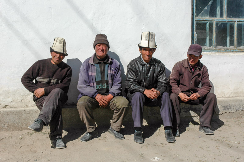
I am mostly hosted in Mashhad by Pouria, a student my own age originally from Tehran, son of a general of the Iranian Air Force. Pouria is an intelligent and sensitive young man, presently questioning his faith, and through him I get a cherished insight into the lives of the young, liberal, educated Iranian middle class. Pouria introduces me to a number of his friends; Alireza, a chubby, ebullient manic-depressive; Hamid, a handsome womaniser and rather poor student of architecture; Mohammad, impeccably well spoken but self-destructive, and brothers Ali and Mehdi who run a small restaurant White Food where we often congregate in the evenings. We sit in Hamid’s apartment around a traditional Iranian korsi, a charcoal brazier under a large blanket into which we all tuck our legs, whilst drinking sweet tea and smoking a qelyan (water pipe), whilst Hamid tells us of his back-seat trysts with various women in the hills outside town. We meet strikingly beautiful young women who rip-off their concealing exterior garments (required of women in public by law), the moment they come indoors, to reveal far skimpier attire. We go to private parties attended by both sexes (illegal), where young men and women dance freely together. We drink home-made alcohol which the Iranians call arak saagi or ‘dog liquor’. I spend roughly ten days with Pouria and his cohorts and am treated at every moment like an old friend, immediately welcomed into his inner circle. These young students will go on to become highly qualified engineers, doctors and academics but sadly almost all will leave Iran over the coming years, driven out by social and economic realities; a great loss for the country and its future.

Mausoleum of Ferdowsi, Tus, Razavi Khorasan Province, Iran
Aside from the joys of Mashhad’s underground night-life, Pouria and his friends demonstrate a side to their culture beyond the hedonism which they share with the youth of the West. In the nearby village of Tus, now almost part of the sprawling suburbs of Mashhad, they take me to a place which they hold in some reverence; the tomb of the poet Ferdowsi. By the ninth century, Abbasid control of eastern Iran had given way to the Samanid Empire, ruled from Samarkand and Bukhara. This was a time of transformation of the Persian language, with much Arabic having crept in as a means of spreading Islam across the empire. Ferdowsi was commissioned by the Samanids (who claimed descent from the pre-Islamic Sassanians) to write a Persian epic poem in order for the Persians not to forget their language and identity, and escape the Arabisation which befell, for example, Egypt. Ferdowsi’s epic Shahnameh, which he completed in 1010, is something like a Persian mix of Shakespeare and Homer, in which real historical figures such as Alexander the Great and the Achaemenid shah Darius play part-real, part-mythical roles, along with the wholly mythical brothers of the heroic legend Rustam and Sohrab.
Today, Iranians still hold their classical poets in great esteem; every Iranian household has copies of beloved laureates such as Hafez or Saadi on their shelves and the shrines of these figures are visited by both religious and secular-leaning Iranians. Ferdowsi’s mausoleum was restored by the secular- minded Reza Shah Pahlavi (father of the last Shah, Mohammad Reza Pahlavi) who also launched an ultimately unsuccessful campaign to rid the Persian language of Arabic loanwords. For many young, educated Iranians, driven away from Islam by the dour, politicised theology of the ruling ayatollahs, visiting the shrine of, for example, Ferdowsi is a chance to connect with their non-Islamic, Iranian identity.

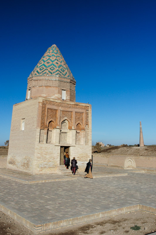
Mausoleum of Arslan Jadhib, Sang Bast, Razavi Khorasan Province, Iran
I leave Pouria and Mashhad having glimpsed a very interesting side of Iranian society and having made a life-long friend. I drive south out of the city, embarking upon a nine-hundred kilometre journey to the modern capital, Tehran. Today, the contrast between Iran and the newly-independent Central Asian republics of the Former USSR, struggling to assert their identity after having unexpectedly become nation states for the first time in history, is rather clear. Before the Russian conquest of Central Asia in the eighteenth and nineteenth centuries however, Iran was often a far larger entity and this north-easterly region, still known today as Khorasan and my favourite part of the country, was home to successive arrivals from the interior of Asia, each of whom shaped Iranian history but would ultimately assimilate into the Persian-dominated civilisation. Very soon after leaving Mashhad, I am out into barren desert and I make my first stop near the village of Sang Bast, less than thirty kilometres out of Mashhad. Here, lying unguarded in the desert is a beautiful mausoleum of a regional official of the Ghaznavid Empire named Arslan Jadhib.

Khosrogerd Minaret, Sabzevar, Razavi Khorasan Province, Iran
The Ghaznavids were a Turkic dynasty who came from Ghazni in present-day Afghanistan and established an empire covering much of what is now eastern Iran, Afghanistan, Pakistan and even parts of north-western India, where they are widely credited with introducing Islam. The Ghaznavids would become Persianised in their culture and their architecture, where it has survived the wrath of the Mongols, is some of the earliest extant Islamic architecture in Iran. Jadhib’s lonely mausoleum which dates from the early eleventh century is a simple, square-based, domed structure and has a fine, free-standing brick minaret which I ascend by its narrow internal spiral staircase. From the top of the minaret I have an enchanting view of the khaki desert plains of Khorasan undulating towards a low, distant mountain range sweeping towards the tantalising border of Afghanistan to the south-east; a view which stirs something deep inside me.
From Sang Bast I join Highway 44 and begin the long eastward journey, stopping at a sacred spring in a beautiful garden oasis known as Qadamgah, where pilgrims heading towards Mashhad stop in droves to collect water from a spring said to have been used by Imam Reza, then continue to the ancient city of Nishapur. Nishapur was once a city of great cultural importance, famed for its turquoise and pottery, but rather like the other great cities of Khorasan; Merv and Balkh, it was utterly razed by the Mongols in the thirteenth century and never recovered. It’s also famous worldwide as the birthplace in 1048 of Omar Khayyam, a Persian polymath renowned for his contribution to mathematics and poetry in what became known as the Islamic Golden Age. Khayyam and other contemporary intellectuals such as physicians Razi and Avicenna, fellow mathematician Khwarizmi and the geographer Biruni were all of Iranian origin and made a huge contribution not just to the Islamic world, but to the twelfth century Renaissance in medieval Europe.

Mausoleum of Bayazid Bastami, Bastam, Semnan Province, Iran
Despite its illustrious history and contributions to the world, present-day Nishapur is nothing more than a provincial town and I’m soon back on the road. Highway 44 follows an ancient trade route which would have connected Constantinople and Baghdad with the cities of Khorasan and Transoxiana. It’s still an important modern transport artery and between cities, old fortified caravanserais and mud-brick settlements slowly crumble away and fill with wind-blown dust and sand. On the one hand they appear dejected remnants of the pre-modern age but as I pass these silent monuments I get the feeling of being on a living, historic trade route. Nowhere in Central Asia, with all its over-restored monuments have I felt so much to be travelling on the Silk Road itself. One of the most beautiful of these monuments lies just outside the city of Sabzevar; the Khosrogerd Minaret, built in the early twelfth century by the Seljuks, another Persianised Turkic dynasty which grew up in Khorasan conquering territory from the Ghaznavids. The minaret is almost thirty metres high and covered in bands of beautiful brick strapwork, and is all that remains of a settlement destroyed by the Mongols in the thirteenth century. It is free-standing, in the pre-Mongol style, and is thought to have been a marker post for travellers on the Silk Road; giving me visions of weary camel caravans sighting the distant needle and looking forward to resting in one of the long-gone caravanserais.

Pir-e Alamdar Tomb, Damghan, Semnan Province, Iran
I spend a cold night at the roadside and in the morning explore the tranquil small town of Bastam, home to the shrine of Bayazid Bastami. The Silk Road was a conduit not just for the transfer of goods, but also of ideas and individuals. Bayazid Bastami was a mystic Sufi wanderer who developed the doctrine of sukr or religious ecstasy in Islam; bodily annihilation in the presence of the divine, not dissimilar from certain ascetic Hindus of the Indian Subcontinent. In fact, later Sufi mystics such as Bastami were instrumental in spreading Islam in India where it gelled and hybridised with existing Hindu beliefs.
As Seljuk control in Khorasan weakened in the mid twelfth century, their vassals the Khwarazmians, another Persianised Turkic dynasty based in the Khwarezm Oasis took control of Khorasan. It was this fateful dynasty however who provoked the ire of Chinggis Khan, leading to his Mongol hordes sweeping across civilised Asia, killing and destroying very nearly all before them between 1219 and 1221. Chinggis Khan’s grandson Hulagu came to inherit a subdued Iran and his Ilkhanate, part of the Greater Mongol Empire would like so many other invaders before, become Persianised and oversee a period of religious tolerance, a flowering of the arts and a facilitation of communication along the Silk Road which would foster the first contact between China and Europe, through figures such as Marco Polo.

Dasht-e Kavir, Semnan Province, Iran
The Ilkhans converted to Islam in 1295 and in 1300 Öljaitü, great-grandson of Hulagu was initiated as a Sufi here in Bastam. Öljaitü later became leader of the Ilkhanid Empire and rebuilt the shrine of Bayazid into a beautiful architectural complex which survives to this day, distinctive for its conical tiled minarets and richly decorated portals with gorgeous turquoise-glazed brick strapwork.
I spend the afternoon in the ancient, pistachio-growing town of Damghan which has several finely banded Seljuk-era brick minarets and the rather plain Tarikhaneh Mosque, one of the oldest mosques in the country. The scenery west of Damghan is particularly beautiful in the late afternoon light with plains dotted by saxauls rolling towards distant desert hills to the south and the bulk of the Alborz Mountains off to the north. After another cold night I stop briefly the following morning in Semnan, the largest town I have passed through since leaving Mashhad, then push on west. Slowly, the settlements become more frequent; more of the caravanserais have been restored, and the road loses some of its Silk Road atmosphere until it reaches the ugly industrial satellite towns and sprawl of the capital.

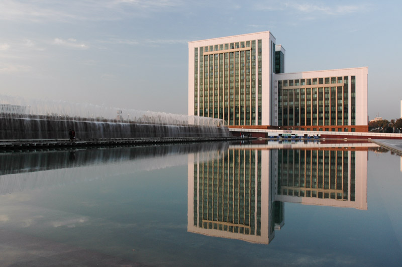
North Tehran, Tehran Province, Iran
Tehran is a deceptive and on first sight rather unlovable city; fittingly contradictory, like so much in modern Iran. Located at the foot of the Alborz Mountains, the site which Tehran occupies was once ancient Rhages, capital of the Medes (predecessors of the Achaemenids) and in medieval times was known as Rey, one of the capitals of the Seljuks. Rey was razed by the Mongols and was of no importance until, bearing the name Tehran, it was made the Iranian capital in the late eighteenth century by the Qajar king Agha Mohammad Khan. Visually, the city looks like little more than a modern sprawl of hastily built, buff-coloured city blocks and for a country with such a rich history of architecture, Tehran comes as a surprise for having barely a single architectural landmark. Yet it plays a vital part in recent Iranian history; it was here that the Pahlavis came to power in the early twentieth century, largely rebuilding Qajar Tehran and ushering in uncontrolled urban expansion following the Second World War. This was the seat of the last shah of Iran, who commissioned the huge Shahyad Tower (later to be called the Azadi Tower) to commemorate the 2500th year of the Imperial State of Iran. And it was here that furious masses, angered by the corruption, ‘Westoxification’ and religious repression of the last Shah rose up in 1979, ending that imperial state, only for it to be replaced by a (some would say equally corrupt) regime of hardline clerics. The one time Embassy of the United States is now something of a monument in central Tehran, standing in testimony to the 444-day hostage crisis which has soured relations between the present regime and the US.

Former US Embassy, Tehran, Tehran Province, Iran
Today’s Tehran continues to grow endlessly but is very roughly divided between north and south with the wealthy living in the steep streets of the north, in districts which edge ever further up the flanks of the Alborz, overlooking the centre; and the working class south, a sprawling sea of housing which sits for many months of the year under a pall of photochemical smog. Through my host Reza, a forty year-old bachelor who lives in a smart suburb of North Tehran and runs his own software business, I am introduced to the underground, secular private life of Tehran. A large number of similar, moneyed North Tehranis live private lives little different from those of urban Westerners and at the house-parties to which I am taken I see Western clothes, Western music and smuggled Western alcohol, though the strikingly beautiful women are of course fully Iranian. Tens of thousands of such Tehranis are happily westoxified in the privacy of their own homes. But as is always the case in Iran, one is never far from seeing another, totally opposite side to the country and its people.

Bazaaris, Tehran, Tehran Province, Iran
Throughout Western Asia, the bazaar, or market, is usually the centre of public city life. In contrast to Western supermarkets or shopping malls, the bazaar is more than a place simply to purchase goods. In Iran, it is a particularly tight-knit mix of the marketplace, mosque and the state. Tehran’s bazaar is vast; the commercial heart of the city and a district in itself. Though most bazaaris (traders) appear piously conservative, modest and humble, many are very wealthy and, more importantly, politically influential. So from a visit to the bazaar one may equally judge the price of basic commodities or the political and economic mood of the entire country. Kilometres of timeworn passageways are lined with every conceivable commodity, and one must push through crowds and avoid trolleys, piled high with goods and being pushed and pulled by boys who shout to part the seething crowds. In a rueful corner I stop to look at some Iranian pistachios, probably the finest in the world, and am immediately invited to pause for a cup of tea and a chat.

Martyrs Cemetery, Qom, Qom Province, Iran
I make a side-trip to nearby Qom, Iran’s most conservative city, built around the shrine of Fatima Masumeh, sister of Imam Reza, which seems rather less busy with pilgrims than the shrine in Mashhad. Qom is the world’s largest centre of Shia scholarship and it was here that Ruholla Khomeini studied theology and later led resistance against the reforms of the last Shah, until his exile in 1964.
I stay a few more days in Tehran but leave failing to have warmed to the city very much, beyond the generous, intellectual and entertaining company of Reza. On my way out of Tehran, I make a brief stop in the country’s largest cemetery, Behesht-e Zahra (Paradise of Zahra, a daughter of the Prophet Muhammad) on the city’s southern outskirts. Together with the strangely shabby yet unfinished nearby mausoleum of Khomeini, this seems to constitute something of a day out for South Tehranis; plainly-dressed families with unruly children pace around the grounds with no particular aim and I’m left wondering if they are here simply to enjoy the tranquil surroundings (a rare treat in Tehran), or whether there is really some deeper fondness of grief, mourning and martyrdom. A small souvenir booth sells postcards; not of the manicured rosebushes and pine trees, or of the impressive polished stone monuments, but of hideously mutilated bodies on battlefields of the Iran-Iraq War; headless cadavers slumped over wrecked vehicles, severed limbs and broken skulls.

Imam Mosque, Isfahan, Isfahan Province, Iran
I continue south crossing barren plains and passing salt lakes towards the beautiful former capital city of Isfahan. The Ilkhanate was ravaged by the Black Plague in the early fourteenth century and, after a time of rival Mongol factions, was conquered by Tamerlane at the end of the same century. When Timurid power weakened, Iran splintered into multiple regional dynasties until, in 1501 Shah Ismail I, a descendent of the Kurdish mystic Sheikh Safi-ad Din of the Safaviyya Sufi order, seized power and rapidly established the Safavid Empire. The Safavids marked a turning point in Iranian history; a native dynasty who forged a unified Iranian empire, the first since the Sassanians. The Safavids also promoted Shia Islam from a minority sect into the official religion in the state, a landmark event in Muslim history. The Safavid Empire may indeed be seen as the start of Iran’s modern history; progenitors of the culture landscape of modern Iran.
The Safavids were great patrons of architecture and art and it is little surprise that Isfahan, their longest-serving capital, is almost certainly modern Iran’s finest and most celebrated city. The city’s centrepiece is the seventeenth century Naqsh-e Jahan (Image of the World) Square, with a huge manicured central park of grass and fountains, surrounded by a perimeter of countless arches in two tiers; the lower giving access to shops and workshops of the city’s merchants and artisans and the upper, neat white portals leading to simple dormitory cells.

Naqsh-e Jahan Square, Isfahan, Isfahan Province, Iran
At the southern end of the square is the stunning Imam Mosque, one of the greatest achievements in architecture of the Islamic World, which the Safavids designed drawing on the rich architectural legacy of Iran; a four iwan (portal) open courtyard design taken from early Seljuk mosques and stunning, multicoloured tiles in the style of Timurid Samarkand. Unlike modern Samarkand however, the courtyard of the Imam Mosque is still very much in use, part of the fabric of Isfahani life. At the square’s western edge is the small Sheikh Lotfollah Mosque, a private mosque for the Safavid court, unusual for having no courtyard and no minarets but, in my opinion, one of the most beautiful mosques in the world for its neat dome of mostly beige and turquoise faïence. Through an outer portal one enters a vaulted passageway covered entirely in turquoise and lapis mosaic tiles, curving to the right and leading into the domed, windowless main chamber of the mosque where one is left in awe of the dazzling magnificence and intricacy of geometric designs which climb the walls onto the interior of the dome.

Dome of Sheikh Lotfollah Mosque, Isfahan, Isfahan Province, Iran
Overlooking the square from its eastern side is the Ali Qapu Palace, an open-fronted pavilion with carved wooden columns in the style of a Bukharan Mosque, where the Safavid shahs would entertain guests with the magnificent view of the imperial capital as a backdrop. At the square’s northern edge is the entrance to Isfahan’s, warren-like network of bazaars which, in the typical Iranian style incorporate not just shop-stalls, but also caravanserais, mosques and shrines. While some of the bazaar is bland and modern, in other parts its an evocative walk through beautiful vaulted passageways deeply pleasing to the senses; bright colours of cloth and confectionery, the murmur of business transactions and, most evocatively, the smell of spice stalls. Here, sacks of spices, dried seeds and pods, leaves and flowers create an unmistakable melange of aromas; a smell one could never encounter in a western shopping mall or supermarket, indescribably complex with hints of clove, dried lime, saffron and nutmeg. To me it is the smell of Iran.

Painting of Chaharshanbe Suri, Chehel Sotoun Palace, Isfahan, Isfahan Province, Iran
Off to the east of the square is the Chehel Sotoun, a pleasure palace set in a tranquil Persian garden, notable for its fine interior artwork with epic paintings of Safavid battles such the 1510 Battle of Taher Abad where Shah Ismail I defeated the Shaybanid Uzbeks or Nader Shah engaging the Moghuls (complete with elephants) in the 1739 Battle of Karnal. Other paintings in the miniature style depict fanciful scenes of comely dancing girls, scantily clad or even half-nude, thankfully preserved from the hands of zealous vandals during the Islamic Revolution in 1979. It’s a good example of how the world seems to be returning to conservatism, something which has its roots in no small part in the 1979 Iranian Revolution and almost simultaneous Soviet invasion of Afghanistan in the same year.
In a country consisting almost entirely of arid high plains, mountains and deserts, water is particularly pleasing to the Iranian eye and the thrashing blue waters of the Zeyandeh River, which flows through the heart of the city, south of the square and palaces, gives Isfahan a second focus. Here too the Safavids indulged their love of architecture with long, graceful footbridges across the river. The finest of these are the seventeenth century, two-tiered Si-o Se (Thirty Three) Bridge, which has the tables of a tea house set out just above the water level under its thirty-three arches, and the Khaju Bridge under whose lower arches locals congregate in the evening to sit and chat, smoke a qelyan, or in a peculiarly Isfahani tradition, sing together, using the acoustic properties of the arches to great effect.

Khaju Bridge, Isfahan, Isfahan Province, Iran
On Friday afternoon I return to the square and listen to a cleric giving an anti-American sermon at the Imam Mosque, then watch as hundreds of women in chadors (black, unsewn capes), men in plain clothes and a few junior clerics in flowing beige robes move out of the mosque and disperse into the bazaar and the snarling mass of small motorcycles which pervade every single thoroughfare in every single city in Iran. I wonder at the divisions in a country where in one week I can dance and drink vodka with model-beautiful, professional women in salubrious North Tehran and see crowds of hundreds in medieval costume leaving a polished seventeenth century mosque having taken in a sermon demonising Western influences. I am beginning to realise however that Iranian society is deeply contradictory.
After the sermon, I meet Rae, a pretty thirty year-old Singaporean who is struggling with her chador. I immediately hit it off with Rae; she has a genuinely impressive set of travel tales; living in forbidden parts of Burma, sleeping out alone in freezing Tibetan villages where locals were afraid she was Chinese, and making an illegal trip by donkey from Egypt into Libya.

Amin od-Dowleh Caravanserai, Kashan, Isfahan Province, Iran
Rae and I drive to Kashan the following day, stopping in beautiful Abyaneh, a village of mud-walled houses made from local red clay, set in a dramatic valley of now-leafless poplars. We reach Kashan in the evening and decide to stay in a mosaferkhaneh (basic hostel), a place I would usually take pains to avoid staying at. The place is run by a scruffy and bad tempered man who tells me there is an additional charge to use a locked shower in a bathroom which reeks of urine. More spurious charges appear in the morning, which I refuse to pay, causing the screaming owner to nearly chase us down the street. This echoes experiences I’d had as a backpacker in Iran in 2003 and still leaves me wondering why, in a nation of friendly and welcoming people, hotel owners are often the most unpleasant individuals.
Kashan, nestled between the eastern ridges of the Zagros Mountains and the deserts of central Iran, was a retreat for the Safavid shahs, but the city was largely destroyed by an earthquake in the late eighteenth century. Today it has a fine bazaar whose highlight is the beautiful nineteenth century Amin od-Dowleh Caravanserai, with an ocular skylight which reflects light from a central pool to illuminate the portals of various shops, a beautiful piece of civic architecture. Kashan is however most famous for its fine merchants’ houses which date from the late eighteenth and nineteenth centuries, the time of the Qajar Dynasty.

Tabatabaei House, Kashan, Isfahan Province, Iran
The Safavids were succeeded by the short-lived Zand Dynasty, who in turn were succeeded by the Qajars; yet another Persianised Turkic dynasty who would rule Iran from the late eighteenth century until 1925. The Qajars however are often not remembered very fondly in modern Iran; it was under the Qajars that Iran lost territory to the Russian Empire, losing the Caucasus and Transoxiana. The scheming Qajar old-guard also assassinated Amir Kabir, the nineteenth century reformist prime minister of Iran, after sending him into exile here in Kashan. The Qajars would eventually descend into the very picture of decadent, pompous, wastrel kings, squandering state funds on private adventures to the point of bankruptcy and opening the country to malign foreign intervention and occupation, not least of all by the British, and it is in the nineteenth century Qajar-era that the deeply-held Iranian mistrust of the British begins.
We visit two separate houses in the city; both fine pieces of architecture with opulent courtyards containing pools and trees, but one feels the vanity of the Qajars in them; heavy on external plasterwork ornamentation but lacking the genius of so many earlier Iranian architects.
Rae and I are unfortunately travelling in separate directions across the country and so after dropping her off at the bus station in the evening, I continue alone, missing her company, climbing up into the freezing Zagros Mountains of western Iran to continue a journey even deeper into the history of this fascinating country.
Stage 5 – Uzbekistan & Turkmenistan: The Great Deserts

The two great deserts of Central Asia; the Kyzyl Kum (Red Sands) in Uzbekistan, and the Kara Kum (Black Sands) in Turkmenistan, for a long time served to isolate the interior of Asia, both by the physical difficulty of traversing such an unforgiving, waterless waste and by the barbaric Turkmen tribes who would rob and either kill or kidnap outsiders caught in the region. When the first European explorers penetrated these sandy frontiers of the known-world, to the Khorezm Oasis, they were shocked to see white slaves; Russians kidnapped from the frontier of then Tsarist Russia. My route would now take me through these deserts in order to reach the Iranian frontier. On leaving Uzbekistan in August, I’d had more than my fill of over-restored and museum-like relics of the old Central Asian khanates (kingdoms), but on this second visit the country would reveal a few new and more subtle attractions. In contrast, my crossing of Turkmenistan, which I had not planned to visit until recently deciding to avoid Afghanistan, would offer a fascinating glimpse of one of the world’s most reclusive countries.

Uzbek Family, near Denau, Surxondaryo Region, Uzbekistan
It’s the 10th October 2007. I’ve just left Tajikistan and after a typically arduous entry into Uzbekistan, I’m on the final stretch of the M41 heading south to the city of Termez which lies on the Amu Darya facing Afghanistan. After all the rough roads and basic conditions of Tajikistan’s mountains, it’s refreshing to be in the balmy late-summer heat of Uzbekistan’s southern plains, driving on roads which are asphalted and in pretty good shape. So high are my spirits in fact (boosted by the fact that in no-man’s land the car had stopped, and what in my auto-hypochondria had been a terminal engine problem had in fact been a battery terminal problem: the cable just needed tightening), that I decide to try my hand at a little ‘induced-hospitality’. I stop at a random point on the road where some farmers are returning from the day’s work and ask a loaded question; ‘Is there a hotel here?’ Of course, there isn’t, we’re surrounded by fields and farmsteads, but one of the farmers immediately invites me to stay at his home.

Kugitang Range, near Termez, Surxondaryo Region, Uzbekistan
The family home, a simple but spacious single-storey house typical of the region is set in a courtyard strung with vines and walnut trees, and sparsely furnished though comfortable in the interior. The family are Uzbek cotton farmers, living in a region which is populated fairly equally by both Uzbeks and Tajiks. In the course of the evening a parade of people come through and with my few words of Russian, conversation is extremely limited. I soon begin to realise, as neighbours and distant relatives come through to meet me, that I’m probably the first foreigner most of them have ever had any contact with. It’s something of a privilege, though also quite hard work. The men recline, cracking walnuts and drinking cups of light green tea one after another, heated on a simple electric hob, while the women generally attend to household chores though occasionally come to join the conversation. Dinner is shorpa, a tasty meat and vegetable broth with the ubiquitous nan, thick round loaves of heavy bread made in a wood-fired oven. In the morning, I’m given a bowl of delicious fresh yoghurt for breakfast into which my host throws three huge lumps of crystallised sugar, whilst the local children who have caught wind of my presence cup their faces onto the windows from outside to get a look. Before leaving, I wish to give the family a gift of some kind and find a box of Iranian dates which I had picked up in the barren bazaar of Murghab in the Pamirs. This causes a worried look on the faces of the women who soon produce a football-sized bag of walnuts as a reciprocal gift. As interesting and life-affirming as it is, such encounters are quite tiring as one is a constant source of attention and interest. There are people who travel using such spontaneous hospitality routinely, though personally, a quiet night alone in the car suits me better on most occasions.

White Palace, Shahrisabz, Qashqadaryo Region, Uzbekistan
Termez is a pleasant enough place and the regional museum has an interesting array of neolithic artefacts found in the nearby mountains, but I press on in the afternoon, winding up a pass in the Kugitang Mountains which are thrust out of the ground in great jagged ridges like huge rows of teeth. Beyond the pass the road slowly descends and crosses the plains to the small city of Shahrisabz. It was in the vicinity of Shahrisabz, known at the time as Kesh, that Amir Timur (Tamerlane in the West), was born in 1336. A controversial figure who saw himself a descendent of Chinggis Khan and sought to restore the great man’s empire, Timur was both a patron of the arts (seen in all the Timurid buildings scattered throughout the region), and a vicious destroyer and butcher of the civilisations he encountered when expanding his short-lived empire beyond its Central Asian heartland. Although born in modern-day Uzbekistan, Timur was of Turko-Mongol stock and his credentials as anything other than a distant ancestor of modern-day Uzbeks is highly questionable. Nevertheless, he has been rigorously promoted as the national hero of independent Uzbekistan and in most of the cities where an old statue or bust of Lenin was taken down and disposed of, a statue of Timur on horseback has appeared. Young schoolchildren will obediently tell how they love the great Amir Timur.

Zerafshan Range, Qashqadaryo Region, Uzbekistan
One of Timur’s greatest constructions was his own summer palace, the Ak Saray (White Palace), in Shahrisabz. Unlike his other masterpieces in the country, the Ak Saray remains very much a ruin; only stumps of its sixty-five metre archway, the largest in the world at the time, remain and the outer tiles are only patchily present on the building’s vast exterior. This however immediately gives the place a more authentic historical patina without the hasty restoration found elsewhere. What remains of the tilework is noticeably finer than that recently created and used to restore Samarkand’s Registan, for instance. The town also houses the surprisingly restrained building that was intended to be Timur’s mausoleum, though following his death in Otrar (in present-day Kazakhstan) after an unsuccessful campaign in China in 1405, his body was only brought back as far as Samarkand where it remains today.
I’m happy to reach the Bahodir’s guesthouse in Samarkand where I run into Miguel again, who is finally planning, after five years away, to return home to see his ageing mother. I then head back to Tashkent to collect a visa for Turkmenistan. During this ten-day sojourn in the capital, I have a random but highly significant meeting with a Swiss traveller named Fabian. I’d spoken to him briefly in the guesthouse in Samarkand but when I chance upon him in a metro carriage he tells me that the Pakistan Embassy is issuing visas with minimal fuss, and as a result I accompany him to the embassy, ultimately deciding to go to Pakistan after my upcoming visit to Iran, rather than crossing the Persian Gulf to Arabia.

Monument of Courage, Tashkent, Uzbekistan
Tashkent is one of my favourite cities. It was almost entirely destroyed in 1966 by an earthquake and as a result most of modern-day Tashkent was built as a giant, monumentalist city of the Soviet Union during the heady days of the 1960s and ’70s. Most visitors spend as little time as necessary here (as I did on my first visit), but with free-use of the Grachev’s flat, and plenty of time waiting for visas, I being to fall in love with the place. It’s absolutely different from the rest of the country; cosmopolitan, down-to-earth, and free of tourists. It’s something of a multicultural city (within Soviet limits) with large Russian, Korean and Tatar communities. In a county where all traces of the Russian and Soviet periods are being systematically erased; monuments dismantled, names changed, histories re-written, Russians have tended either to leave (like the Grachev’s), or at least to flock to the capital. Those few Russians that I saw in the countryside and provincial towns, who had ‘gone native’, were few and far between. Without the support of the extended families which the native Uzbeks and Tajiks usually have, such Russians often looked pretty desperate. Government policies and national pride have marginalised the Russian language (though almost everyone over the age of twenty-five can speak the language); a major impetus, along with economic chaos and rampant corruption, for Russians to leave. However in many parts of Tashkent, such as the area in which I’m living, Russian is the language on the street.
Independence Square, Tashkent, Uzbekistan
Nail, the son of the Suleimanov’s who live in the flat next-door to the Grachev’s, is an interesting example of post-Soviet identity. Born and brought-up in Tashkent, Nail is Tatar on his father’s side, and half-Bashkir (a Turkic nation from the Urals close to Tatars), half-Russian on his mother’s. He is what Kapuściński would call Homo sovieticus, that is, a product of Soviet multiculturalism. Yet despite never having lived in Russia and being just one-quarter Russian, he considers himself more Russian than anything else. Nail would refer to Uzbeks as ‘national people’ and clearly distanced himself from their traditions and culture. He embodied the sentiment of many Russians I met in Central Asia; people whose forebears had been of the hegemonic Russian state, had brought the unifying language, and who often held the belief that they had come as a civilising force to ‘uplift’ the backward Asian nations, now saw themselves in the opposite field, marginalised ethnically, linguistically and economically. It was a surprise at first to see that most of the beggars in Tashkent, and Bishkek for instance, were ethnic Russians, very often the elderly, and it’s an unfortunate social phenomenon which can be seen across many of the newly independent states of the Former USSR (including the Baltic countries which have joined the EU). Nail, predictably, has since moved to Russia and is currently seeking Russian citizenship.

Yunusobod District, Tashkent, Uzbekistan
Whilst in the Metro one day I get to know Akbar, an Uzbek student of languages. Eighteen year-old Akbar seems extremely glad to meet a native speaker of English and insists that I visit his Lyceum. Slightly daunted, I enrol Fabian as a companion, though not being a native English speaker, he is of somewhat lesser interest to Akbar and his friends. We are taken along the corridors of the old Soviet building to briefly partake in various classes, and are expected to be experts in each discipline; I have to recall some mathematics and Fabian some IT skills, though neither of us get far in the Uzbek-language class. Most of the teaching seems to be by rote and repetition. The visit culminates with an assembly where we’re wheeled in front of the entire student body of eleven to eighteen year olds and asked questions. Here we get an insight into what education is in a totalitarian state. The questions we get are exactly the same each time; ‘What is your favourite [Uzbek] national dish?, ‘Do you know any words of Uzbek?’ and ‘Do you like Uzbekistan’ are common examples. The only slightly intelligent question comes from a teacher: ‘What do people in your country think of Uzbekistan?’ This is a difficult question; firstly, what proportion of British adults I wonder, could point at Uzbekistan on a map, or are even aware that the country exists? I try to think what might be carried in the news; a president that boils his enemies alive, one of the most corrupt countries on Earth, child labour, the Aral Sea disaster, remnant Soviet bio-weapons… A few moments’ quick thinking and I tell them: Samarkand, cotton and the delicious national dish, plov. This goes down very well.
The Soviet Union’s educational system may not have been free from Marxist-Leninist rhetoric, but the country had very nearly 100% literacy, the highest in the world. In Central Asia standards of education at all levels, have plummeted since 1991 thanks to poor teachers’ salaries (in 2007 a teacher might earn $100 per month in Uzbekistan), a lack of quality materials in the newly adopted national languages, endemic corruption and general neglect of the educational sector.

Amu Darya, near Lebap, Bukhara Region, Uzbekistan
From Tashkent I return to Samarkand, bid Miguel a final goodbye and set off, passing Bukhara and then entering the Kyzyl Kum Desert. After leaving the city the road heads for around three-hundred kilometres roughly parallel to the Amu Darya through barren land until reaching the Khorezm Oasis. Driving alone in the benign autumn temperatures, on this quiet desert road, is something close to bliss. Sand dunes appear in stretches, often spilling onto the highway and on the horizon distant rock formations float like islands in the desert haze. Nearing the oasis, a narrow band of fertile greenery skirts the river, beyond which I enter the barren autonomous republic of Karakalpakstan where the irrigated land suddenly gives out to parched desert. Here lie a number of crumbling, neglected earthen castles, part of the outer defences of the ancient Persian satrapy (province) of Margiana whose capital was at Merv, in modern-day Turkmenistan. As I sit in the lengthening afternoon light in the ruins of Ayaz Kala, one of such castles, it’s easy to imagine this being the edge of an empire; the forbidding wastes beyond being terra incognita, the lands of the Scythians whose defence against the armies of the Persian Emperor Cyrus I was chronicled by Herodotus. What an intriguing concept it must have been for there to have been a part of the world about which nothing whatsoever was known.

Ayaz Kala, Karakalpakstan Republic, Uzbekistan
Happy at seeing something in Uzbekistan which doesn’t look like it was built yesterday, in the most delightfully remote and evocative location imaginable, I push on to the republic’s capital Nukus for a couple of beers in a hotel bar I’d taken a liking to in August. I’m immediately struck, now that I’ve spent considerably more time in Uzbekistan, that the Karakalpaks, whilst physically isolated in this bleak and blighted corner of the country, seem rather more open and worldly than their down-country fellows. Out here, away from the watchful eye of the Tashkent regime I begin to notice that there is individuality to buck the authoritarian uniformity which seems to stifle not only freedom of speech, but freedom of thought, in other parts of Uzbekistan. People here seem to have some notion of the world around them. As Karakalpak is linguistically very close to Kazakh, the television is showing Kazakh channels. People look to Almaty, not Tashkent, as their cultural and economic hub.
Very early in the morning I drive out of the city, finally crossing the slow and muddy remnants of the Amu Darya which last month in the Wakhan Valley in Tajikistan had been a brilliant blue mountain river, and head towards the Turkmenistani border. This second visit to Uzbekistan has given me a far clearer view of the country and an insight into today’s Central Asia, for, whatever its problems, economic, social and political. Uzbekistan is very much the heart of Central Asia.

Torebeg Khanum Mausoleum, Konye Urgench, Daşoguz Region, Turkmenistan
While Karimov’s government has chosen Timur as Uzbekistan’s national hero, Sapamurat Niyazov, the recently deceased president-for-life of Turkmenistan, had a slightly different strategy; he chose himself. The elaborate, eccentric and rather tragic personality cult of Niyazov, who styled himself as Turkmenbashi, or ‘leader of all Turkmen’ seemed to be all that graced the western media about the country. That and its deep isolation and insularity; perhaps no other nation besides North Korea does more to deter the flow of information into and out of its borders. To get into the country with a tourist visa requires a pre-arranged tour and constant supervision by a state tour-guide. However, with a transit visa, which I am using on this crossing of Turkmenistan to Iran, one can move with relative freedom in the country, though only on the pre-determined routing, which is stated on a document given to me upon entry. Taking one’s own vehicle into Turkmenistan incurs considerable costs; over $100 on this occasion, though with diesel heavily subsidised at just over US$0.01 per litre at the pumps, the cost is somewhat offset.
Il Arslan Mausoleum and Qutlugh Temir Minaret, Konye Urgench, Daşoguz Region, Turkmenistan
After all the paperwork at the border is completed by surprisingly friendly and helpful staff, I’m on my way through a familiar landscape of irrigated cotton fields to the rather isolated town of Konye-Urgench. Konye, which in Turkic, means ‘old’, refers to this being the once important city of Urgench, capital of the Khorezm Oasis whose fortunes were destroyed once by the Mongols in the early-13th Century (in one of their bloodiest episodes, quite an accolade), then definitively in the late-14th Century by Timur and a shift in the course of the Amu Darya. The sense of destruction and dereliction here is palpable, though a number of impressive pieces of architecture remain. In some ways it’s my favourite of the old caravan cities of ex-Soviet Central Asia, with far, far more to see than Otrar in Kazakhstan for instance, and far more atmosphere than Khiva or Bukhara. The finest monument is the (Timurid) 14th Century Törebeg Khanum Mausoleum. The interior of its exquisite roof consists of twelve blind arches about the inside circumference of the squinched dome, representing the months of the year, and a hugely intricate faïence ceiling incorporating 365 geometric designs to represent the days of the year. It’s a masterpiece of mathematical art. The nearby 11th Century Gutluk Temir Minaret which has a considerable lean, reaches a height of sixty metres and is the third-highest brick minaret in the world. Finally there is the 12th Century tomb of Khorezmshah Il Arslan, (from a dynasty directly responsible for unleashing the fury of Chinggis Khan on civilised Asia just fifty years after his death), which with a neat conical dome has echoes of an Armenian church. I stay the night at some sort of homestay at a small farm building just outside of town. The Turkmen family are very friendly but slightly aloof; a trait I would find in many Turkmen. Perhaps it’s a trait of Turkmen people, or perhaps in this reclusive country, people feel uncomfortable having too many interactions with a foreigner.
Darvaza Gas Crater, Konye Urgench, Daşoguz Region, Turkmenistan
In the morning I set off to make some real progress across the country. The road runs almost due south across the heart of the country, spanning the wastes of the Kara Kum Desert from north to south. Judging by the road surface, it too was sacked by the Mongols. The vegetation becomes poorer and sparser with distance from the city until suddenly stopping at what must be the last irrigation channel, giving way to the desert. There is no trace of human activity here, but once or twice in the distance I spot some tempting old ruins, much like those I’d seen a few days earlier in the vicinity of Ayaz Kala. To this day, I long to have the time to fully explore this most recalcitrant of countries.
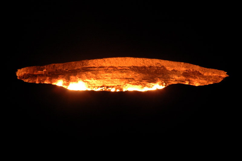
Roughly halfway along the road, near where the village of Darvaza once stood (before the president took a disliking to it and had it levelled), lies one of Central Asia’s most unusual sights. The flaming Darvaza Gas Crater is the result of the collapse of a cavern during gas prospecting in 1971; the natural gas emissions were ignited in an attempt to burn them off but the crater has been ablaze ever since.

Camels, Ahal Region, Turkmenistan
It’s close to sunset when I pull off the road, into the desert around the crater, but I take the wrong route into the dunes and my progress is eventually stopped by the only railway line in the entire desert, with the crater on the far side. However darkness soon falls and I can see the rough position of the crater, given away by a glowing in the sky to the south, and I take off on foot, heading straight for it. My first glimpse of the crater, after cresting a low hill, is breathtaking; it looks almost like a pit of molten lava or perhaps, as the locals call it, a door to hell. I spend a few hours on the crater rim, the wind occasionally bringing gusts of scalding air up from the fiery depths, singeing my hair and frying black desert beetles which charge suicidally towards the light. I marvel at being alone, at night, in the now otherwise freezing desert, at this most bizarre of places. Luckily, I have marked the location of the car on my GPS (or I’d never have found it until morning), and make a direct line back to it in the absolute darkness, tripping over small shrubs and falling down sand dunes.

Presidential Palace Square, Ashgabat, Turkmenistan
Just after the crater, the road to the capital becomes perfect asphalt and I pass numerous dromedary camels slowly plodding along the roadside, before arriving in the capital Ashgabat in the afternoon. This small desert outpost of a city was almost completely destroyed in 1948 in an earthquake which killed roughly two-thirds of the population (I would meet a survivor in north-eastern Ukraine in 2011). As capital of the Turkmen SSR, Ashgabat was of relatively minor importance during Soviet times, but since independence in 1991 has been built up into an exceedingly unusual city.
After from hoarding it for himself (a figure of perhaps $3 billion was held in banks abroad), Turkmenbashi enjoyed nothing more than squandering the income from Turkmenistan’s vast gas and oil reserves on building up his capital (in stark contrast to the neglect in almost all other parts of the country) into a city somewhere between Las Vegas and Pyongyang. Perhaps the most famous of the startling structures which Turkmenbashi had erected in the city is the Arch of Neutrality, a white tapering tower set upon a large tripod, on top of which stands a golden statue of the despot which turns throughout the day in order that the sun is continually shining on his face. There’s also the Independence Monument which has the form of a giant lavatory plunger, and a giant representation of his book the Ruhnama, a mix of history, imagination and rambling poetry and philosophical platitudes.

Arch of Neutrality, Ashgabat, Turkmenistan
This Ruhnama would eventually be promoted by Turkmenbashi to equal status with the Qur’an in the country’s mosques, and the two would be recommended as the only books Turkmen should read. A copy of the Ruhnama even orbits the Earth in its own satellite along with the Turkmen flag. However, Turkmenbashi didn’t limit himself to strange buildings; the most bizarre facets of his reign were some of his decrees, which included changing the names of the months of the year, and of the days of the week (names included that of his mother, and of course himself), inventing holidays (including ‘Melon Day’), closing all hospitals in the country outside of the capital, banning long hair and beards, banning dogs from the capital, banning opera, ballet and circus, and even banning gold teeth (a favourite throughout Central Asia), encouraging citizens instead to gnaw on bones to strengthen their own natural teeth. Alongside these absurdities there was of course also a darker side of repression, incarceration and disappearances of ‘dissidents’ to the reign of one of the most totalitarian dictators of modern times.
With all these diversions, I almost forget about trying to find the ‘real’ side to a city where many central streets are deserted, with almost no normal, everyday activities to be seen. Central Ashgabat feels sterile, cold and distant, with no discernible soul whatsoever.

Carpets, Tolkuchka Bazaar, Ashgabat, Turkmenistan
The one place where I do find some activity, on my last morning in the country, shortly before leaving for the Iranian border, is the Tolkuchka Bazaar, located a few kilometres north of the city, well away from the ghostly streets and lunatic monuments. In stark contrast to the city centre, this huge and sprawling market is perhaps the most colourful and interesting bazaar I’ve ever seen in Central Asia. It seems that the local population (and in Central Asia, city life always revolves around the bazaar) flocks here to get away from the surreality of the city centre, patrolled by police and devoid of amenities. Here one feels far less controlled,and in the narrow, bustling lanes of the bazaar where colourfully dressed Turkmen women go about their shopping, I am back in storybook Central Asia. The bazaar sells everything imaginable, but the most interesting stalls are those selling carpets. In a region where nowadays most people buy and sell only the large, bland machine-made carpets from China, here there are still plenty of real Turkmen rugs. In deep reds, crimsons and blacks with their dazzling hexagonal teke designs, each different style representing a different Teke tribe. These are in my opinion the most beautiful of carpets, but as exporting a rug of any substantial size is troublesome, I settle upon a very small piece, still emblematic and hand-made, which costs just two US Dollars.
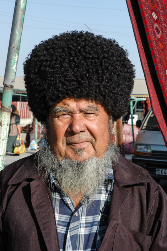
Turkmen Man, Ashgabat, Turkmenistan
But what of the Turkmen people, who had to suffer the erratic decrees of the president which titillated international audiences reading the odd despatch from Turkmenistan? What of the Turkmen, who were once the scourge of the Central Asian deserts; fierce, barbaric, marauding tribesmen; murderers, rapists and plunderers? The Turkmen were the last people to be added to the Tsarist Russian Empire (after two stunning victories over the Russians in the 18th and 19th centuries) in 1878 following the Russian siege of Geok Teppe which could fairly be described as genocide; every last Turkmen was butchered, men women and children. It was about the Turkmen that the Russian general Komaroff famously said: “The harder you hit them, the longer they stay down”. Perhaps that’s what’s happened. In my five days I have met few Turkmen, but in those I have met I see no resemblance in behaviour to the Turkmen described in history. I’ve found Turkmen people friendly and mild almost to the point of timidity, reserved, and totally apolitical. They seem to live in a vacuum, utterly removed and unaware of the outside world, perhaps as they always have been, preferring to tend to their immediate needs and little else, and to not get involved with anything that doesn’t concern them. They are amongst the most culturally isolated people I have encountered. I would meet further Turkmen in Iran and Afghanistan over the coming years, and revisit the country in 2009, but nothing has ever really changed this opinion of mine; that Komaroff gave them such a blow, then the Soviets, then Turkmenbashi, that the Turkmen have no perception of any modicum of political self-empowerment. From the bazaar, I cross Ashgabat one final time, through more soulless, spotless, empty streets, and climb up into the Kopet Dag Mountains towards Iran and another world altogether.

Tolkuchka Bazaar, Ashgabat, Turkmenistan
So concluded my 2007 journey through Central Asia and through the Former USSR. I’ve greatly enjoyed the region with its rich, interwoven history and all the monuments which testify to this, and the vast, open landscapes so different from anything in my native western Europe. I’d also had an insight into perhaps the most interesting facet of the region; five brand-new countries which have never before existed as independent entities, which are struggling to extricate themselves from the economic chaos of the collapsed USSR, to organise themselves and establish and assert a national identity in this geopolitical region nestled between Russia, China, Iran, Pakistan, Afghanistan and India. I’m thankful for being one of the first generations in history to have freely explored the region, and have developed a deep interest in, and affection for it. 2007 would not be the last of my Central Asian journeys.
Stage 4 – Tajikistan: The Pamirs
 Tajikistan is a small, largely mountainous republic in an isolated corner of Central Asia, nestled between Uzbekistan, Kyrgyzstan, China and Afghanistan, and covering much of the Pamir Mountain region. Emerging from the ruins of the Soviet Union in 1991, the country soon plunged into several years of civil war, something which alongside an almost total lack of resources, and very limited infrastructure makes it one of Asia’s poorest nations, and the poorest in the Former USSR. In spite of these rather negative statistics the country is rich in extraordinary scenery, and welcoming mountain communities maintaining a more traditional existence than anywhere else in Soviet Central Asia. Driving the spectacular Pamir Highway would be the realisation of a long-held dream, and one of the highlights of my journey in Central Asia, leaving behind the more touristy areas I had recently visited and glimpsing an area almost untouched by the modern world. In all my future travels in the Former USSR, I would remember the Pamirs of Tajikistan as being one of very few areas which seemed almost untouched by the 20th Century rigours of Bolshevism.

Lake Karakul, Gorno-Badakhshan Autonomous Region, Tajikistan
On the 27th September 2007 I climb away on a frigid autumn morning from the Kyrgyzstani customs post, up the rough track to the top of the 4280 metre Kyzyl Art Pass which overlooks a spectacularly rugged landscape of vast, utterly empty red and grey valleys, now flecked with the first wind-blown snow of the impending winter. Up here three Tajikistani border guards work in virtual exile, awaiting the trickle of international traffic in their customs post which consists of two converted railway oil tankers. Procedures are pretty smooth and I’m soon gliding gently south, down towards the tiny settlement of Karakul which is named for the striking turquoise lake nearby which has formed in an ancient meteorite crater. The elevation is just under four thousand metres, the air is thin and cold and the views other-worldly; an almost flat plain of sand and evenly-scattered pebbles a little like an unraked Zen garden, devoid of life but for a few hardy clumps of grass and sitting below a backdrop of the smoothed peaks of the Pamirs. These peaks of five and six-thousand metres, with their glaciated upper faces, look like mere rolling hills from this altitude.
Karakul, Gorno-Badakhshan Autonomous Region, Tajikistan
The road I am driving on, known as the Pamir Highway, has been a trade route for centuries, following one of the few viable routes to cross from Western and Central Asia into China. The largely asphalted modern-day highway itself is an astounding piece of Soviet engineering; built purely as a military supply route for this most remote and sensitive of the Soviet Union’s borders. Today the road serves no real purpose other than in linking the clutch of tiny settlements between Sary Tash in Kyrgyzstan and Khorog in Tajikistan with the outside world. During Tajikistan’s protracted and bloody civil war in the 1990s, the local Pamiri Tajiks were pitched against the forces of the current government and harboured and supplied many of the rebels thanks to the porous border with Afghanistan and this single road. Though the area is now peaceful, this recent animosity combined with the natural isolation and lack of resources or agriculture means that the Pamirs, known administratively as Gorno-Badakhshan Autonomous Region, are severely undeveloped and politically ostracised by the Dushanbe government. These political and ethnic divisions between Pamiri Tajiks and those of the western lowlands mean the region is virtually unconnected to the rest of Tajikistan, desperately poor and economically propped-up by foreign aid, much of it coming from the Aga Khan foundation which supports the Pamiri communities, many of whom are Ismaili Muslims.
Kyrgyz Men, Karakul, Gorno-Badakhshan Autonomous Region, Tajikistan
The village of Karakul is one of the most forlorn and far-flung settlement I’ve ever seen, one of those places which forces one to ask oneself what people could possibly do here for survival. In a place where winters regularly hit -40°C with bitter winds, hours by road from the nearest town, and days away from a city with any measure of amenities, where there is no public transport and perhaps three cars per day passing on the road, it’s difficult to imagine what force originally attracted, or more likely necessitated people to move here. The town’s population is in fact Kyrgyz, incredibly tough people who mostly move far out into the desolate valleys in summer to graze their flocks on the sparse vegetation. Poverty is most likely what keeps people here. It’s only late September, but already it’s -18°C at night and I am very thankful to be sleeping in a cosy chaikhana (teahouse).
From Karakul, the Pamir Highway continues south and reaches its highest point, the barren 4655-metre Ak Baital Pass. This is by far the highest point I’ve yet visited with the car and even a hundred metres higher than the mountain I had climbed in Kyrgyzstan earlier in the month. Although I’m feeling fine, the truck’s naturally aspirated diesel engine is definitely feeling the altitude; on any kind of incline it only manages first or perhaps second gear.

Ak Baital Pass (4665 m), Gorno-Badakhshan Autonomous Region, Tajikistan
On the southern side of the pass lies the town of Murghab, ‘capital’ of the Pamirs and location of the late-19th Century ‘Pamirsky Post’, the most advanced permanent Russian presence into Central Asia. Although Murghab is visibly a backwater and little more than two empty streets and a collection of crumbling Soviet administrative buildings, when compared to Karakul it feels positively urban and lively. A recently opened border with China means there’s a trickle of traffic bringing in low-quality Chinese products for the markets of western Tajikistan, returning with animal skins and scrap metal to resource-hungry China. However Murghab still lacks a telephone connection (fixed or mobile), and electricity is erratic. It is in Murghab that I pick up Ray, an Australian backpacker whom I’d run into in Bishkek and again in Karakol a few weeks ago. Fifty year-old Ray, a divorcee, spends the Antipodean winter travelling in the northern hemisphere, returning for the summer where he works grading mining tracks and spending time with his ‘summertime girlfriend’. I greatly enjoy Ray’s company, envying his lifestyle somewhat and we would come to travel together for the next ten days, myself calling him ‘Old Fella’ and he referring to me as ‘The Blouse’ for my careful driving style on the dirt tracks of the Pamirs.

Pamir Highway, near Alichur, Gorno-Badakhshan Autonomous Region, Tajikistan
The road descends very gradually from Murghab and the scenery becomes very slightly less austere, the peaks lower, and isolated Kyrgyz yurts begin to dot the empty landscape. By late afternoon we reach the settlement of Alichur where we meet our first Tajiks. The Tajiks are something of an ethnic anomaly in post-Soviet Central Asia; Aryan people of distant Iranian lineage, remnants of the ancient Persian satrapies (provinces) of Bactria and Sogdia, while their neighbours are all Turkic. The Tajiks are however by no means a homogeneous race, having had centuries of localised isolation and intermarriage with their various neighbours.
We find lodging with a Pamiri Tajik family; extremely kind people with strikingly European-looking faces. As is common due to the pressures of poverty, many of the men of the family work in Moscow or other major Russian cities, a situation so widespread that the word tajik has come to denote a migrant worker in contemporary Russian slang. The Pamiri Tajiks, whose religion is highly secretive and private, are Ismaili Muslims, a sect broken away from the Shiites of Iraq and Persia who believe the Aga Khan is the present-day descendant of the Prophet Mohammad, and a vision of God. Ismaili women are noticeably more empowered than their Sunni or Shia counterparts, for most of whom the idea of hosting two foreign, male strangers would be an unthinkable scandal.
Tajik And Kyrgyz Children, Alichur, Gorno-Badakhshan Autonomous Region, Tajikistan
Alichur is in fact half-Tajik and half-Kyrgyz. While the village kids seem to play freely together, skating on frozen puddles with crude toboggans and scrap-metal ski-poles, there is some animosity between the adults of the two communities and their respective dwellings lie on opposite sides of the village. The Tajiks, seen as arrogant and soft by the Kyrgyz, live in furnished and cosy homes year-round, and have a private place of worship, not a mosque but a Jamatkhana, something akin to a community centre. The Kyrgyz, seen as wild and uncivilised by the Tajiks, live in cruder, unadorned homes in winter, moving out onto the surrounding plains in summer to graze their herds. Ostensibly Sunni Muslims, they maintain a simple mosque in the village.
On our second day in the village, Ray and I go for a walk to some enticing dark mountains to the north, underestimating just how far away they are in this huge landscape of long vistas in rarefied air. We do however twice encounter some Kyrgyz yurts and are invited in for tea and yoghurt on both occasions. Both communities are extremely warm and naturally hospitable people, but it seems a sad fact of the world that even in a place as tough to live in as Alichur, there is inter-ethnic mistrust.

Camel Caravan in Afghanistan, Gorno-Badakhshan Autonomous Region, Tajikistan
After three very pleasant days of home-cooked food and warm, comfortable beds, Ray and I leave our Tajik hosts and drive west, turning off the main Pamir Highway just after Alichur, where we take a seldom-used dirt track south, up and over the Wakhan Mountains and down to the Pamir River, which marks the border with Afghanistan. Beyond the river is the Afghan Pamir, part of the Wakhan Corridor; a long, thin salient of Afghanistan created as a buffer zone between British and Russian Empires in the 19th Century. Just beyond this corridor lie the mountains of the Karakoram and Hindukush of northern Pakistan; a distance of only a few kilometres, but in practical terms it might as well be on the other shore of an ocean, so impenetrable and isolated are these mountains. As we descend alongside the river I finally glimpse one of my cherished, preconceived images of Central Asia; a lone man is driving a caravan of seven dark-brown Bactrian camels along a dusty trail traversing a steep ledge, oblivious of the modern world. I’m overjoyed at finally glimpsing Central Asia as it must have been before European occupation.

Shepherds, Langar, Gorno-Badakhshan Autonomous Region, Tajikistan
As we progress, the river starts to carve ever more deeply into the mountains, with the road running high above it on a rocky ledge. After seventy kilometres of dirt-track along the river, we start to encounter the first real vegetation then very quickly drop down to the scenic town of Langar which sits at 2700 metres. This marks our transition out of the stark, barren Pamirs and into a more fertile and more populated region; ledges above the river are tilled by ox-plough and support far more numerous and prosperous-looking villages. The temperature is also milder, and Langar is an exceptionally likeable place. There is not a single trace of the Soviet past here that I can discern; it looks very much like Pakistan’s Hunza Valley with barely a trace of Russification. Indeed the local Wakhi Tajiks have ethnically and culturally far more in common with fellow Gojali Tajiks in northern Pakistan than with their countrymen around the capital to the west. The only traces of the modern world are the odd car, generator and the telephone lines. There is no plastic litter, and no mobile phones. It feels like a modern-day Shangri-La.
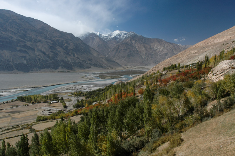
Wakhan Valley, Zong, Gorno-Badakhshan Autonomous Region, Tajikistan
A little beyond Langar the Wakhan River emerges from a steep valley within the Wakhan Corridor and joins the Pamir River to mark the start of the Panj River, which becomes the Amu Darya downstream in the far south-east of Tajikistan. I’ll be roughly following this river for the next month as it makes its way towards the Aral Sea, a journey it will never complete, doomed to be dissipated in the desert wastes of Karakalpakistan due to massive over-use of water by Soviet-era agricultural projects. The colours of the Wakhan Valley are in full autumnal splendour; strands of green, gold and fiery-red streak down the huge valley-sides to the sparkling blue water of the river, which meanders around fluvial islands in the now very broad valley. We pass villages whose inhabitants are busying themselves with the autumn harvest, reaping grain and threshing it in timeless fashion by leading tethered donkeys to walk over great piles of wheat in never-ending circles, then throwing it into the wind with pitchforks to separate the chaff.
The villages here have wonderful names such as Zong, Vrang and Yamg, and the valley is dotted with relics of a bygone age where instead of being forgotten and irrelevant to the outside world, the valley was a bustling trade route. An impressive array of petroglyphs above Langar demonstrate that the region has been inhabited since pre-historic times. There are impressive dry-stone forts, and remains of religious structures which hint at a Buddhist or Zoroastrian history which historically spread along these trade routes, and it is in fact highly possible that Marco Polo passed along this very valley.
Wakhan Valley, Vrang, Gorno-Badakhshan Autonomous Region, Tajikistan
After stopping to cook lunch on a riverbank we have a soak in a local bath-house fed by a warm spring which although murky and just short of being a comfortable temperature, is our first wash in almost two weeks and tremendously welcome. Later we reach Vrang, where crude, pyramidal stone structures sit on the valley-side above the village. Their exact origins are unclear, thought either to be Zoroastrian fire-worshipping platforms or the plinths of long-gone Buddhist stupas. Looking west down the valley as the sun drops behind the mountains is a beautiful scene; a bucolic patchwork of green and golden fields dotted with slender poplar trees running along the Panj as it twists around successive fingers of mountains, all fading away into the distant haze. We spend the night in the nearby village of Yamg in a small Pamiri-style guesthouse run by the head teacher at the village school. A veritable feast of a meal washed down with vodka ends a very pleasant day.
After Yamg, the magic of the upper valley fades as it becomes totally barren; the riotous colours and quaint mud-brick houses of the villages disappear and the unsurfaced road deteriorates. We pass dunes of wind-blown sand in the river valley and it is only after a long and rather dull stretch of road that we start to see trees once again, though the nature of the landscape is never as pleasant as before. We pass another military checkpost, and soon find ourselves in the grim administrative town of Ishkashim where we spend a night before continuing to the small city of Khorog, capital of Gorno-Badakhshan Autonomous Region.
Panj River, near Khorog, Gorno-Badakhshan Autonomous Region, Tajikistan
Khorog is pleasant and lively stop where we re-provision, enjoy genuinely warm weather for the first time in weeks and register with the local police, but after two days we rejoin the road along the Panj, heading for the capital. The scenery here becomes less spectacular, though at times is made pleasant by shady stretches of mulberry or polar trees and small villages. Looking across the now narrow river to roadless villages in Afghanistan where there is not even glass in the windows of the dry-stone dwellings, one gets the impression more of looking across time than across space, and I am filled once more with a longing to visit the neighbouring country. Despite having returned to relative civilisation compared with the Pamirs, the road surface is gradually degenerating, lashed by rivers and pounded by lorry traffic and the journey along the Panj becomes dull and monotonous, enlivened only by the indicated presence of land mines at the roadside and the odd wrecked military vehicle, both legacies of the civil war.

Kulob Road, near Kalaikum, Gorno-Badakhshan Autonomous Region, Tajikistan
We arrive at the junction town of Kalaikum after dark and find lodging in a simple but comfortable guesthouse run by the local museum curator, where we have a light supper of dried figs and mulberries with green tea before turning in for a well-earned rest. In the morning we choose to continue following the Panj, rather than the even rougher direct route to the capital. Apart from a rather sureal forty-kilometre stretch of new Turkish asphalt around Zigar, the road is truly apalling, a jarring, painfully slow ordeal. By late morning we cross the Obinisu River and enter the region of Khatlon, marking an ethnic transition into a region which the Pamiri Tajiks fought against during the civil war. Khatlon Region in fact saw the heaviest fighting in the civil war, though perhaps in part due to being the homeland of the president, Emomali Rahmon, the region has seen far more development than the mountains to the east of here.
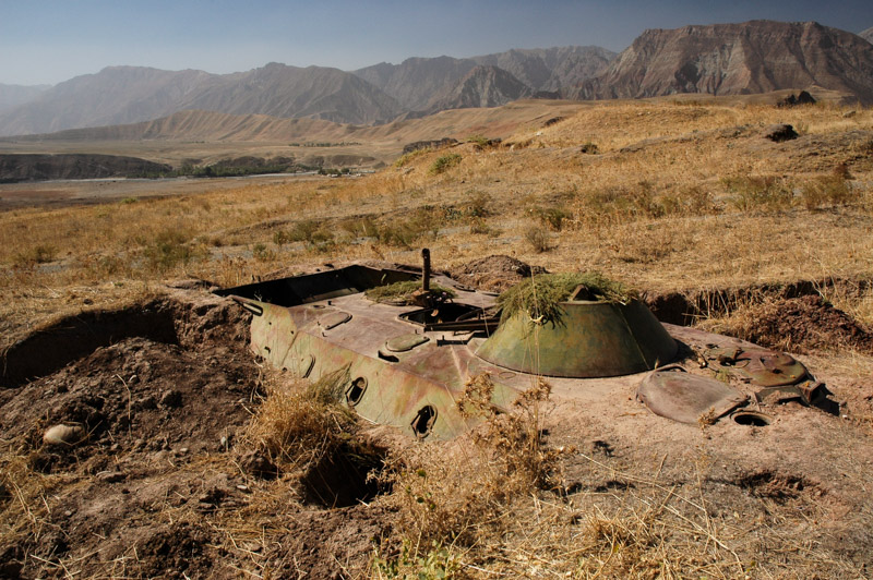
Wrecked Personnel Carrier, near Shurobod, Khatlon Region, Tajikistan
By early afternoon, after a day and a half of torturous and mostly unpleasant driving we finally leave the Panj and begin to climb north, soon passing the town of Shurobod where we see Tajik men dressed in traditional Central Asian padded velvet tunics; a clear sign of greater Turkic cultural influence than was present in the Pamirs. We enter the farmed lowlands which typify south-eastern Tajikistan, the centre of the country’s cotton, wheat and fruit productuion, forcibly collectised by the Soviets in the 20th Century. Mercifully, the asphalt starts here again and we descend quickly to Kulob, where we stop and admire a bazaar crammed full of the widest range of goods that we’ve seen since Kyrgyzstan, including for the very first time fresh fruit and vegetables. Along with these spoils of modernity also come drawbacks however, here in the form of the bribe-hungry traffic police who attempt (unsuccessfully) to elicit a bribe upon seeing a foreign vehicle.
From Kulob we cross the undulating fields amid collective farms, passing villages with no trace of progression since 1991, then wind up into the hills passing the deep blue water of the dam at Nurek, which supplies power to the capital. We make the final descent to Vahdat where a four-lane motorway leads swiftly to the capital, Dushanbe, which is where Ray and I must go our separate ways. I’m quite sad to see Ray walk off into the dark to find a hostel, though I don’t join him as I’m kindly being hosted for a night by Anna, a British human rights lawyer whom I had met last in August in Kyrgyzstan.

Haji Yakub Mosque, Dushanbe, Tajikistan
The following day is the last on my visa but before departing I have a quick look around the capital. Dushanbe, which was little more a provincial backwater before suddenly being made the national capital in 1991, revolves around Rudaki Avenue, a single thoroughfare of spruced-up Stalinist-era buildings. Between the gaps in the smart, pastel-coloured ministries and offices one can already see the outskirts and even the fields beyond the city, but aside from the traffic police it is a pleasant, if slightly dull place. The centrepiece of the city is a large square paved in red sandstone containing a triumphal arch, under which is a statue of Ismail Samani, the 9th-10th Century amir (commander) of the Samanid Dynasty, the first native Persian dynasty to arise following the Arab conquest of the Sassanians. Regarded as the founder of the first Tajik State, Samani has become the government’s chosen national hero in this new and rather fractious country. The cultural link with Persia has endured to the modern-era however, with the city’s large and beautifully-tiled 19th Century Haji Yaub Mosque showing a clearly Persian design. After independence from the USSR in 1991, Tajikistan was quick to re-establish links with Iran, a country which remains a major benefactor.
Early in the afternoon I leave the city, heading west on the final leg in the counry, past the smoke-belching aluminium plant in Tursunzade to the border complex at Druzhbi. After one last unsuccessful attempt by a member of the Tajikistani law enforcement to extract a bribe, I am allowed past the checkpoint and leave Tajikistan, ready to begin my second trip into Uzbekistan.

Ismoil Somoni Monument, Dushanbe, Tajikistan
I leave Tajikistan having thoroughly enjoyed the country, the sublime beauty of the Pamirs and the timeless villages of the Wakhan Valley. At the same time the country feels to have no unity whatsoever; the areas I have visited seem to have no contact, nothing in common with each other and to be almost wholly decentralised from any single authority. In hindsight this was correct, and the civil war was proof of this cohesive fragility, but only for the areas I visited. I was limited to fifteen days in the country due to stringent vehicle import regulations and so chose to spend it in the most beautiful parts. In 2011 I would re-visit the country and in its northern and western areas I would find some kind of central, national identity of Tajikistan. An opinion of mine which has never changed however, is how genuinely warm and hospitable the people: Tajiks, Kyrgyz, and Uzbeks, of Tajikistan are.
