
Stage 4 – Tajikistan: The Pamirs
 Tajikistan is a small, largely mountainous republic in an isolated corner of Central Asia, nestled between Uzbekistan, Kyrgyzstan, China and Afghanistan, and covering much of the Pamir Mountain region. Emerging from the ruins of the Soviet Union in 1991, the country soon plunged into several years of civil war, something which alongside an almost total lack of resources, and very limited infrastructure makes it one of Asia’s poorest nations, and the poorest in the Former USSR. In spite of these rather negative statistics the country is rich in extraordinary scenery, and welcoming mountain communities maintaining a more traditional existence than anywhere else in Soviet Central Asia. Driving the spectacular Pamir Highway would be the realisation of a long-held dream, and one of the highlights of my journey in Central Asia, leaving behind the more touristy areas I had recently visited and glimpsing an area almost untouched by the modern world. In all my future travels in the Former USSR, I would remember the Pamirs of Tajikistan as being one of very few areas which seemed almost untouched by the 20th Century rigours of Bolshevism.

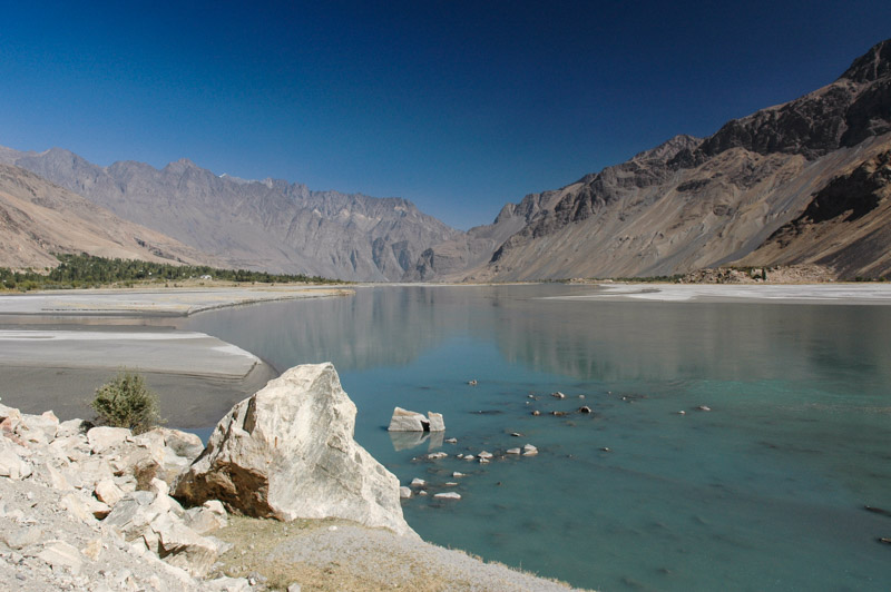
Lake Karakul, Gorno-Badakhshan Autonomous Region, Tajikistan
On the 27th September 2007 I climb away on a frigid autumn morning from the Kyrgyzstani customs post, up the rough track to the top of the 4280 metre Kyzyl Art Pass which overlooks a spectacularly rugged landscape of vast, utterly empty red and grey valleys, now flecked with the first wind-blown snow of the impending winter. Up here three Tajikistani border guards work in virtual exile, awaiting the trickle of international traffic in their customs post which consists of two converted railway oil tankers. Procedures are pretty smooth and I’m soon gliding gently south, down towards the tiny settlement of Karakul which is named for the striking turquoise lake nearby which has formed in an ancient meteorite crater. The elevation is just under four thousand metres, the air is thin and cold and the views other-worldly; an almost flat plain of sand and evenly-scattered pebbles a little like an unraked Zen garden, devoid of life but for a few hardy clumps of grass and sitting below a backdrop of the smoothed peaks of the Pamirs. These peaks of five and six-thousand metres, with their glaciated upper faces, look like mere rolling hills from this altitude.
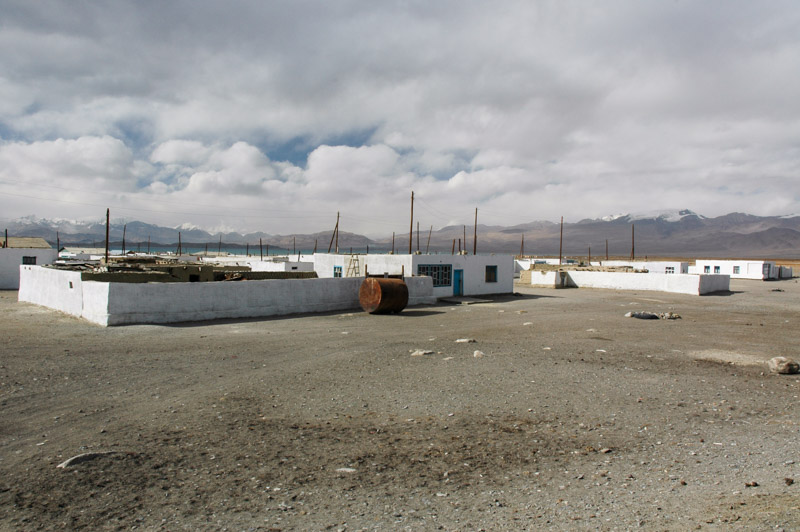
Karakul, Gorno-Badakhshan Autonomous Region, Tajikistan
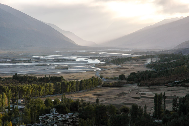
The road I am driving on, known as the Pamir Highway, has been a trade route for centuries, following one of the few viable routes to cross from Western and Central Asia into China. The largely asphalted modern-day highway itself is an astounding piece of Soviet engineering; built purely as a military supply route for this most remote and sensitive of the Soviet Union’s borders. Today the road serves no real purpose other than in linking the clutch of tiny settlements between Sary Tash in Kyrgyzstan and Khorog in Tajikistan with the outside world. During Tajikistan’s protracted and bloody civil war in the 1990s, the local Pamiri Tajiks were pitched against the forces of the current government and harboured and supplied many of the rebels thanks to the porous border with Afghanistan and this single road. Though the area is now peaceful, this recent animosity combined with the natural isolation and lack of resources or agriculture means that the Pamirs, known administratively as Gorno-Badakhshan Autonomous Region, are severely undeveloped and politically ostracised by the Dushanbe government. These political and ethnic divisions between Pamiri Tajiks and those of the western lowlands mean the region is virtually unconnected to the rest of Tajikistan, desperately poor and economically propped-up by foreign aid, much of it coming from the Aga Khan foundation which supports the Pamiri communities, many of whom are Ismaili Muslims.
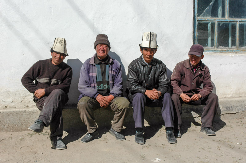
Kyrgyz Men, Karakul, Gorno-Badakhshan Autonomous Region, Tajikistan
The village of Karakul is one of the most forlorn and far-flung settlement I’ve ever seen, one of those places which forces one to ask oneself what people could possibly do here for survival. In a place where winters regularly hit -40°C with bitter winds, hours by road from the nearest town, and days away from a city with any measure of amenities, where there is no public transport and perhaps three cars per day passing on the road, it’s difficult to imagine what force originally attracted, or more likely necessitated people to move here. The town’s population is in fact Kyrgyz, incredibly tough people who mostly move far out into the desolate valleys in summer to graze their flocks on the sparse vegetation. Poverty is most likely what keeps people here. It’s only late September, but already it’s -18°C at night and I am very thankful to be sleeping in a cosy chaikhana (teahouse).
From Karakul, the Pamir Highway continues south and reaches its highest point, the barren 4655-metre Ak Baital Pass. This is by far the highest point I’ve yet visited with the car and even a hundred metres higher than the mountain I had climbed in Kyrgyzstan earlier in the month. Although I’m feeling fine, the truck’s naturally aspirated diesel engine is definitely feeling the altitude; on any kind of incline it only manages first or perhaps second gear.

Ak Baital Pass (4665 m), Gorno-Badakhshan Autonomous Region, Tajikistan
On the southern side of the pass lies the town of Murghab, ‘capital’ of the Pamirs and location of the late-19th Century ‘Pamirsky Post’, the most advanced permanent Russian presence into Central Asia. Although Murghab is visibly a backwater and little more than two empty streets and a collection of crumbling Soviet administrative buildings, when compared to Karakul it feels positively urban and lively. A recently opened border with China means there’s a trickle of traffic bringing in low-quality Chinese products for the markets of western Tajikistan, returning with animal skins and scrap metal to resource-hungry China. However Murghab still lacks a telephone connection (fixed or mobile), and electricity is erratic. It is in Murghab that I pick up Ray, an Australian backpacker whom I’d run into in Bishkek and again in Karakol a few weeks ago. Fifty year-old Ray, a divorcee, spends the Antipodean winter travelling in the northern hemisphere, returning for the summer where he works grading mining tracks and spending time with his ‘summertime girlfriend’. I greatly enjoy Ray’s company, envying his lifestyle somewhat and we would come to travel together for the next ten days, myself calling him ‘Old Fella’ and he referring to me as ‘The Blouse’ for my careful driving style on the dirt tracks of the Pamirs.

Pamir Highway, near Alichur, Gorno-Badakhshan Autonomous Region, Tajikistan
The road descends very gradually from Murghab and the scenery becomes very slightly less austere, the peaks lower, and isolated Kyrgyz yurts begin to dot the empty landscape. By late afternoon we reach the settlement of Alichur where we meet our first Tajiks. The Tajiks are something of an ethnic anomaly in post-Soviet Central Asia; Aryan people of distant Iranian lineage, remnants of the ancient Persian satrapies (provinces) of Bactria and Sogdia, while their neighbours are all Turkic. The Tajiks are however by no means a homogeneous race, having had centuries of localised isolation and intermarriage with their various neighbours.
We find lodging with a Pamiri Tajik family; extremely kind people with strikingly European-looking faces. As is common due to the pressures of poverty, many of the men of the family work in Moscow or other major Russian cities, a situation so widespread that the word tajik has come to denote a migrant worker in contemporary Russian slang. The Pamiri Tajiks, whose religion is highly secretive and private, are Ismaili Muslims, a sect broken away from the Shiites of Iraq and Persia who believe the Aga Khan is the present-day descendant of the Prophet Mohammad, and a vision of God. Ismaili women are noticeably more empowered than their Sunni or Shia counterparts, for most of whom the idea of hosting two foreign, male strangers would be an unthinkable scandal.
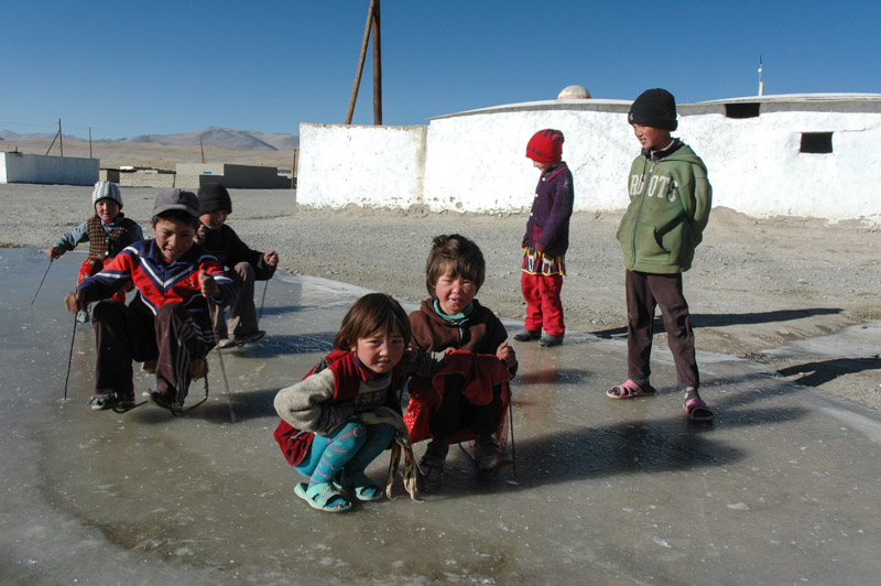
Tajik And Kyrgyz Children, Alichur, Gorno-Badakhshan Autonomous Region, Tajikistan
Alichur is in fact half-Tajik and half-Kyrgyz. While the village kids seem to play freely together, skating on frozen puddles with crude toboggans and scrap-metal ski-poles, there is some animosity between the adults of the two communities and their respective dwellings lie on opposite sides of the village. The Tajiks, seen as arrogant and soft by the Kyrgyz, live in furnished and cosy homes year-round, and have a private place of worship, not a mosque but a Jamatkhana, something akin to a community centre. The Kyrgyz, seen as wild and uncivilised by the Tajiks, live in cruder, unadorned homes in winter, moving out onto the surrounding plains in summer to graze their herds. Ostensibly Sunni Muslims, they maintain a simple mosque in the village.
On our second day in the village, Ray and I go for a walk to some enticing dark mountains to the north, underestimating just how far away they are in this huge landscape of long vistas in rarefied air. We do however twice encounter some Kyrgyz yurts and are invited in for tea and yoghurt on both occasions. Both communities are extremely warm and naturally hospitable people, but it seems a sad fact of the world that even in a place as tough to live in as Alichur, there is inter-ethnic mistrust.

Camel Caravan in Afghanistan, Gorno-Badakhshan Autonomous Region, Tajikistan
After three very pleasant days of home-cooked food and warm, comfortable beds, Ray and I leave our Tajik hosts and drive west, turning off the main Pamir Highway just after Alichur, where we take a seldom-used dirt track south, up and over the Wakhan Mountains and down to the Pamir River, which marks the border with Afghanistan. Beyond the river is the Afghan Pamir, part of the Wakhan Corridor; a long, thin salient of Afghanistan created as a buffer zone between British and Russian Empires in the 19th Century. Just beyond this corridor lie the mountains of the Karakoram and Hindukush of northern Pakistan; a distance of only a few kilometres, but in practical terms it might as well be on the other shore of an ocean, so impenetrable and isolated are these mountains. As we descend alongside the river I finally glimpse one of my cherished, preconceived images of Central Asia; a lone man is driving a caravan of seven dark-brown Bactrian camels along a dusty trail traversing a steep ledge, oblivious of the modern world. I’m overjoyed at finally glimpsing Central Asia as it must have been before European occupation.

Shepherds, Langar, Gorno-Badakhshan Autonomous Region, Tajikistan
As we progress, the river starts to carve ever more deeply into the mountains, with the road running high above it on a rocky ledge. After seventy kilometres of dirt-track along the river, we start to encounter the first real vegetation then very quickly drop down to the scenic town of Langar which sits at 2700 metres. This marks our transition out of the stark, barren Pamirs and into a more fertile and more populated region; ledges above the river are tilled by ox-plough and support far more numerous and prosperous-looking villages. The temperature is also milder, and Langar is an exceptionally likeable place. There is not a single trace of the Soviet past here that I can discern; it looks very much like Pakistan’s Hunza Valley with barely a trace of Russification. Indeed the local Wakhi Tajiks have ethnically and culturally far more in common with fellow Gojali Tajiks in northern Pakistan than with their countrymen around the capital to the west. The only traces of the modern world are the odd car, generator and the telephone lines. There is no plastic litter, and no mobile phones. It feels like a modern-day Shangri-La.
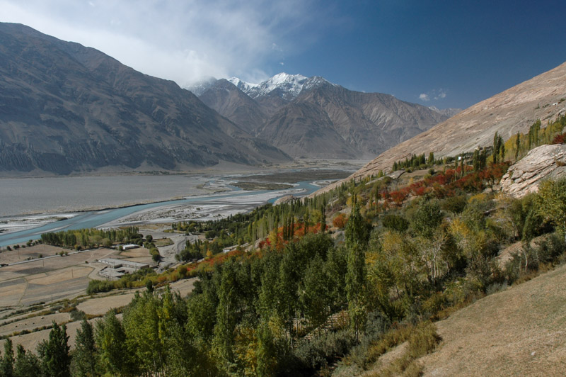
Wakhan Valley, Zong, Gorno-Badakhshan Autonomous Region, Tajikistan
A little beyond Langar the Wakhan River emerges from a steep valley within the Wakhan Corridor and joins the Pamir River to mark the start of the Panj River, which becomes the Amu Darya downstream in the far south-east of Tajikistan. I’ll be roughly following this river for the next month as it makes its way towards the Aral Sea, a journey it will never complete, doomed to be dissipated in the desert wastes of Karakalpakistan due to massive over-use of water by Soviet-era agricultural projects. The colours of the Wakhan Valley are in full autumnal splendour; strands of green, gold and fiery-red streak down the huge valley-sides to the sparkling blue water of the river, which meanders around fluvial islands in the now very broad valley. We pass villages whose inhabitants are busying themselves with the autumn harvest, reaping grain and threshing it in timeless fashion by leading tethered donkeys to walk over great piles of wheat in never-ending circles, then throwing it into the wind with pitchforks to separate the chaff.
The villages here have wonderful names such as Zong, Vrang and Yamg, and the valley is dotted with relics of a bygone age where instead of being forgotten and irrelevant to the outside world, the valley was a bustling trade route. An impressive array of petroglyphs above Langar demonstrate that the region has been inhabited since pre-historic times. There are impressive dry-stone forts, and remains of religious structures which hint at a Buddhist or Zoroastrian history which historically spread along these trade routes, and it is in fact highly possible that Marco Polo passed along this very valley.
Wakhan Valley, Vrang, Gorno-Badakhshan Autonomous Region, Tajikistan
After stopping to cook lunch on a riverbank we have a soak in a local bath-house fed by a warm spring which although murky and just short of being a comfortable temperature, is our first wash in almost two weeks and tremendously welcome. Later we reach Vrang, where crude, pyramidal stone structures sit on the valley-side above the village. Their exact origins are unclear, thought either to be Zoroastrian fire-worshipping platforms or the plinths of long-gone Buddhist stupas. Looking west down the valley as the sun drops behind the mountains is a beautiful scene; a bucolic patchwork of green and golden fields dotted with slender poplar trees running along the Panj as it twists around successive fingers of mountains, all fading away into the distant haze. We spend the night in the nearby village of Yamg in a small Pamiri-style guesthouse run by the head teacher at the village school. A veritable feast of a meal washed down with vodka ends a very pleasant day.
After Yamg, the magic of the upper valley fades as it becomes totally barren; the riotous colours and quaint mud-brick houses of the villages disappear and the unsurfaced road deteriorates. We pass dunes of wind-blown sand in the river valley and it is only after a long and rather dull stretch of road that we start to see trees once again, though the nature of the landscape is never as pleasant as before. We pass another military checkpost, and soon find ourselves in the grim administrative town of Ishkashim where we spend a night before continuing to the small city of Khorog, capital of Gorno-Badakhshan Autonomous Region.
Panj River, near Khorog, Gorno-Badakhshan Autonomous Region, Tajikistan
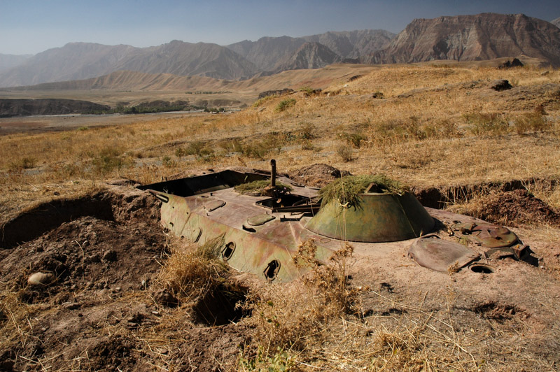
Khorog is pleasant and lively stop where we re-provision, enjoy genuinely warm weather for the first time in weeks and register with the local police, but after two days we rejoin the road along the Panj, heading for the capital. The scenery here becomes less spectacular, though at times is made pleasant by shady stretches of mulberry or polar trees and small villages. Looking across the now narrow river to roadless villages in Afghanistan where there is not even glass in the windows of the dry-stone dwellings, one gets the impression more of looking across time than across space, and I am filled once more with a longing to visit the neighbouring country. Despite having returned to relative civilisation compared with the Pamirs, the road surface is gradually degenerating, lashed by rivers and pounded by lorry traffic and the journey along the Panj becomes dull and monotonous, enlivened only by the indicated presence of land mines at the roadside and the odd wrecked military vehicle, both legacies of the civil war.

Kulob Road, near Kalaikum, Gorno-Badakhshan Autonomous Region, Tajikistan
We arrive at the junction town of Kalaikum after dark and find lodging in a simple but comfortable guesthouse run by the local museum curator, where we have a light supper of dried figs and mulberries with green tea before turning in for a well-earned rest. In the morning we choose to continue following the Panj, rather than the even rougher direct route to the capital. Apart from a rather sureal forty-kilometre stretch of new Turkish asphalt around Zigar, the road is truly apalling, a jarring, painfully slow ordeal. By late morning we cross the Obinisu River and enter the region of Khatlon, marking an ethnic transition into a region which the Pamiri Tajiks fought against during the civil war. Khatlon Region in fact saw the heaviest fighting in the civil war, though perhaps in part due to being the homeland of the president, Emomali Rahmon, the region has seen far more development than the mountains to the east of here.
Wrecked Personnel Carrier, near Shurobod, Khatlon Region, Tajikistan
By early afternoon, after a day and a half of torturous and mostly unpleasant driving we finally leave the Panj and begin to climb north, soon passing the town of Shurobod where we see Tajik men dressed in traditional Central Asian padded velvet tunics; a clear sign of greater Turkic cultural influence than was present in the Pamirs. We enter the farmed lowlands which typify south-eastern Tajikistan, the centre of the country’s cotton, wheat and fruit productuion, forcibly collectised by the Soviets in the 20th Century. Mercifully, the asphalt starts here again and we descend quickly to Kulob, where we stop and admire a bazaar crammed full of the widest range of goods that we’ve seen since Kyrgyzstan, including for the very first time fresh fruit and vegetables. Along with these spoils of modernity also come drawbacks however, here in the form of the bribe-hungry traffic police who attempt (unsuccessfully) to elicit a bribe upon seeing a foreign vehicle.
From Kulob we cross the undulating fields amid collective farms, passing villages with no trace of progression since 1991, then wind up into the hills passing the deep blue water of the dam at Nurek, which supplies power to the capital. We make the final descent to Vahdat where a four-lane motorway leads swiftly to the capital, Dushanbe, which is where Ray and I must go our separate ways. I’m quite sad to see Ray walk off into the dark to find a hostel, though I don’t join him as I’m kindly being hosted for a night by Anna, a British human rights lawyer whom I had met last in August in Kyrgyzstan.

Haji Yakub Mosque, Dushanbe, Tajikistan
The following day is the last on my visa but before departing I have a quick look around the capital. Dushanbe, which was little more a provincial backwater before suddenly being made the national capital in 1991, revolves around Rudaki Avenue, a single thoroughfare of spruced-up Stalinist-era buildings. Between the gaps in the smart, pastel-coloured ministries and offices one can already see the outskirts and even the fields beyond the city, but aside from the traffic police it is a pleasant, if slightly dull place. The centrepiece of the city is a large square paved in red sandstone containing a triumphal arch, under which is a statue of Ismail Samani, the 9th-10th Century amir (commander) of the Samanid Dynasty, the first native Persian dynasty to arise following the Arab conquest of the Sassanians. Regarded as the founder of the first Tajik State, Samani has become the government’s chosen national hero in this new and rather fractious country. The cultural link with Persia has endured to the modern-era however, with the city’s large and beautifully-tiled 19th Century Haji Yaub Mosque showing a clearly Persian design. After independence from the USSR in 1991, Tajikistan was quick to re-establish links with Iran, a country which remains a major benefactor.
Early in the afternoon I leave the city, heading west on the final leg in the counry, past the smoke-belching aluminium plant in Tursunzade to the border complex at Druzhbi. After one last unsuccessful attempt by a member of the Tajikistani law enforcement to extract a bribe, I am allowed past the checkpoint and leave Tajikistan, ready to begin my second trip into Uzbekistan.

Ismoil Somoni Monument, Dushanbe, Tajikistan
I leave Tajikistan having thoroughly enjoyed the country, the sublime beauty of the Pamirs and the timeless villages of the Wakhan Valley. At the same time the country feels to have no unity whatsoever; the areas I have visited seem to have no contact, nothing in common with each other and to be almost wholly decentralised from any single authority. In hindsight this was correct, and the civil war was proof of this cohesive fragility, but only for the areas I visited. I was limited to fifteen days in the country due to stringent vehicle import regulations and so chose to spend it in the most beautiful parts. In 2011 I would re-visit the country and in its northern and western areas I would find some kind of central, national identity of Tajikistan. An opinion of mine which has never changed however, is how genuinely warm and hospitable the people: Tajiks, Kyrgyz, and Uzbeks, of Tajikistan are.
