
Stage 13 – Pakistan & Iran: Thar Desert And The Makran Coast [1/2]

Having spent much of the last six months slowly traversing the arc of mountains from the foothills of Burma to the Afghan frontier, I’m looking forward to the balmy winter warmth of Pakistan’s lowlands and the arid coastline of the Arabian Sea. This stage of my journey will take me from the desert of Sindh to the Persian Gulf port of Bandar Abbas, from where I intend to cross to Arabia and return to Europe on an as-yet unidentified path through Africa. On the way, I will explore one of the region’s least-visited areas, the long, infamous coastline of waterless Balochistan known as the Makran Coast.

Talpur Fort, Naukot, Sindh, Pakistan
I arrive in Hyderabad on the 3rd December 2008, very happy to return to the family home of Aly and Shahana, where I had been so warmly welcomed and invited to spend a month at the beginning of the year. It’s great to meet old friends once again and feel at home in Civil Lines, just beyond the edge of the city’s frenetic centre. The fierce summer heat has abated and with the mild winter temperatures comes the perfect opportunity to travel comfortably in the lowlands of Sindh. On my first weekend I’m excited to hear that Aly plans to make an overnight journey into the Thar Desert and I’m invited to join. The region, known locally simply as Thar, reaches to Pakistan’s tense border with India, making it off-limits to foreigners without special permission. Knowing that such permission will not be forthcoming, we elect to travel in one car; Aly’s venerable and seemingly indestructible Nissan Sunny, Rajkumari, which should help us keep a low profile and hopefully avoid trouble with the army.

Hindu Temple, Sant Nenuram Ashram, Islamkot, Sindh, Pakistan
Taking the wheel of Rajkumari myself, we drive south-east through watered agricultural land which spreads roughly one hundred kilometres from the Indus, through the muddy chaos of small Sindhi towns such as Tando Ghulam Ali, Digri and Jhudo; places where men gather from the villages of the interior to lie and chat on charpais (rope beds) in the bazaar drinking sweet, milky tea and chewing paan (betel nut). In Naukot we cross the last of the irrigation canals and, where their influence ends, the desert begins abruptly. Just beyond the town, a deserted nineteenth century Talpur fort stands sentinel on the desert’s edge, overlooking a low landscape of sand and acacia scrub. This is the Thar Desert, which stretches east across the Indian border and up to the Deccan in the state of Madhya Pradesh. We enter this landscape with a sense of excitement, pleased to find a good, paved road devoid of traffic which undulates over the sandy ridges. Passing through Mithi, we reach the sandy streets of the small desert town of Islamkot which, despite its name, has a population which is approximately ninety percent Hindu.
Islamkot feels very much like India, with winding streets of pastel walls and open sewers, temples and colourfully clad women adorned with bangles and floral nose-studs. It feels to me so similar to India (albeit far more tranquil and friendly) that I at first suspect that Cyril Radcliffe, the English lawyer who had never set eyes upon the Indian Subcontinent yet was responsible for drawing the India – Pakistan border, may have made a slight error in setting it east of Islamkot. On further thought however, I realise that the pluralistic communities of Thar are more of an island; a glimpse of pre-1947 Sindh. That so many Hindus remain in Sindh is testament to the intrinsic tolerance and gentleness of the Sindhis, in stark contrast to Punjab where hundreds of thousands were butchered during the ugly process of partition, and where very few remain today.
Hindu Tribal Women, near Islamkot, Sindh, Pakistan
We spend the night at the ashram (sanctuary) of Sant Nenuram, a Hindu philanthropist who built the ashram in the early twentieth century as a haven for local life, feeding the poor, and even the local desert wildlife. The guardian of the ashram, a grey and bearded, smiling gentleman who radiates good-naturedness, invites us to join the twice-daily bhandhara or communal serving of food in an arcaded room open to the desert. Shahana as ever leads conversation with the old guardian, and I remember other journeys I have made with her meeting the various sages of Sindh, for me a fascinating insight into the syncretic local Sufi culture. In the dark after dinner I wander the grounds of the ashram enjoying the dry desert air in which I get small wafts of incense, further adding to the to the flavour of being in India.
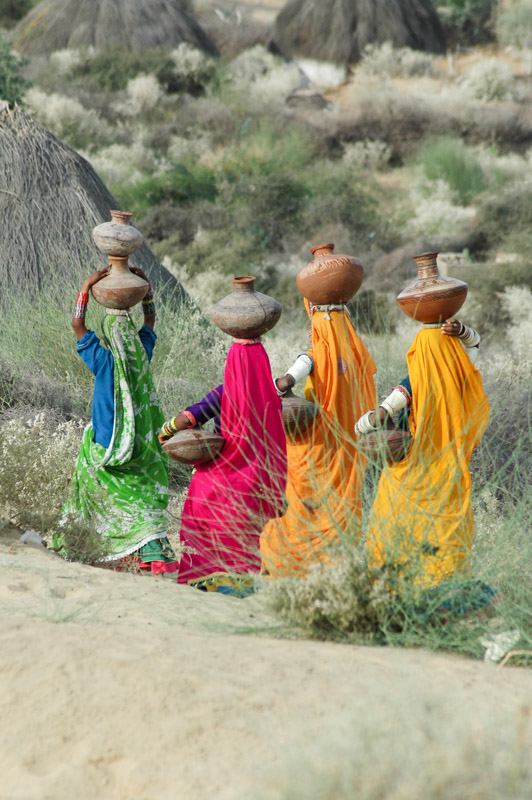
Beyond Islamkot the road continues eastwards, deeper into the desert. Out among the sandy hills, in the shade of spiny acacias are tiny villages of simple thatch-roofed rondavels, unlike anything I’ve yet encountered in South Asia. These villages are home to Hindu tribes whose women, arms wrapped in white bangles, wear vividly coloured saris. We spot a group tribal women carrying decorated jugs of water on their heads, their elegant, coloured forms a striking sight against the greys and browns of the desert.
We turn off the paved road to the village of Gori, on whose northern edge we are surprised to find a large, multi-domed temple built on a raised platform from finely-carved white limestone, far more sophisticated than anything in the surrounding villages and towns. More intriguing is the fact that the temple is wholly abandoned; for it was constructed not by local Hindus, but by a now-vanished community of Jains.

Jain Temple Frescoes, Gori, Sindh, Pakistan
Jainism is an ancient Indian religion whose origins are mythical, but whose recorded history begins with the figure Mahavira, the twenty-forth (and final) tirthankara, or spiritual teacher, of the faith. Mahavira was born to a noble family in the Gangetic Plain of India in around the sixth century BCE and, in a story similar to that of the Buddha, renounced all worldly temptations for an ascetic life of meditation, until he reached kevala janan, or omniscience. Like Buddhism, Jainism rejects the Vedic (Hindu) caste system, but emphasises ahimsa, non-violence, as its central tenet. Unlike Buddhism, Jainism has survived in modern India, though following partition very few Jains elected to remain in Pakistan. What is intriguing (and indeed speculative) are links between Jain iconography and seals found in sites of the Indus Valley Civilisation, which grew along the Indus and later a long-vanished river which once flowed through Thar, which some link to the mythical Sarasvati River. If true, this would link Jains to the earliest, pre-Vedic civilisation of the subcontinent, based here in what is now southern Pakistan.
Gori’s temple is dedicated to the twenty-third tirthankara, the semi-mythical Lord Parshwanath, and is said to have been constructed in the fourteenth century. Though a ruin, it remains largely intact with decoratively carved pillars and some vandalised carved figures. Most unusual however are the frescoes on the interior of the temple’s main dome depicting legends from Jain scripture, which are amongst the oldest Jain paintings still in existence. It’s rather sad to see this beautiful building sitting forlornly out in the desert, visited it seems, by nothing more than an occasional tourist or shade-seeking goat.
Jain Temple, Bhodisar, Sindh, Pakistan
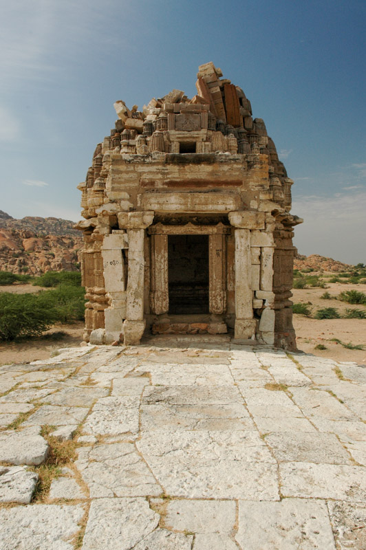
Continuing along the highway, as we near the last town of Nagarparkar we expect an army checkpoint and so Aly takes over driving while I sit in the back hoping not to be spotted. We pass the checkpoint without a problem and the road curves southward towards the ancient yellow granite of the Karunjar Hills, which look very much like India’s Western Ghats. Indeed, behind the hills, out of sight, lies the Indian frontier and the salt flats and marshes of the Rann of Kutch. We stop at the foot of the hills in the village of Bhodisar, where the region’s oldest Jain Temple can be found; a dry-stone structure sitting on a stepped plinth said to date from the ninth century. Part of the shikhara, a tower roof elaborately built up from small, carved subsidiary towers, remains, though neglect and theft are clearly taking their toll.
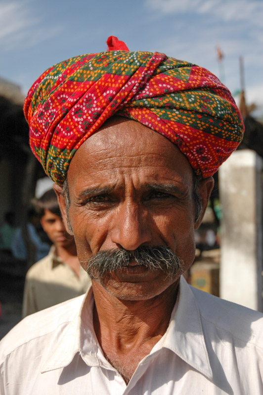
The paved road ends in Nagarparkar, a sensitive south-eastern salient of Pakistan surrounded on three sides by India. It’s a town of colourful sights; Hindu men wearing beautifully wound scarlet turbans remind me of Rajasthan, and large, exuberantly decorated kekras; ancient Diamond six-wheel-drive trucks built by the Americans during the Second World War, which carry goods and people out into the roadless desert. We drive on a track up into the Karunjar Hills, hoping for a glimpse of Kutch, but elect not to push our luck too far and return to town. Here, the so-called Bazaar Temple is the most intact of the Jain temples we see in Thar, complete with a finely carved stone gateway and decorative blind windows, crowned by an intact shikhara. The temple is thought to have been in use up until the time of partition, but is now derelict.
After having something to eat in the bazaar, we are approached by a man who is obviously an army informant who suggests to us that we should leave. We do so with little argument, thankful to have had a glimpse of this remote desert outpost, but when the Punjabi soldier at the checkpoint on the edge of town who failed to notice us driving in stops us and starts shouting, Shahana can no longer hold her tongue: “Don’t you tell me where I can go in my own country!” she bellows, referring to him as an outsider. The soldier has no idea what to say or do, and so we drive off. We enjoy our return drive through the desert, then pick up a terrible, potholed road along which Aly drives furiously, stopping to spend a calm evening with Saloma, a Canadian Mennonite friend of Aly’s in the town of Kunri.
Hindu Man, Nagarparkar, Sindh, Pakistan
I spend the following week in Hyderabad enjoying the warm days and cool nights at the family home. I also put the first new set of tyres on the truck; the used set which have been on since leaving the UK are almost ruined, with one having in fact exploded three weeks earlier on the Grand Trunk Road driving to Taxila. I begin to ponder my next move over which I have long been procrastinating; is it really feasible to head through Arabia into Africa? I am extremely fond of Pakistan, and don’t feel particularly inclined to leave. There’s also the matter of not having visited Afghanistan, which has been technically off limits since the Khyber Pass was closed to foreigners in March this year. I’m certainly in no rush to return to the UK, the mere thought is in fact highly repellent, but I’m not sure if the time is right to go to Africa. Regardless, my Pakistani visa is due to expire, and I must go west for now, into Iran.
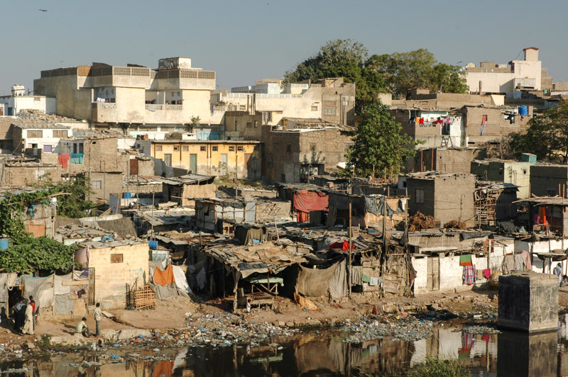
The weekend after our trip into the Thar, we leave Hyderabad in two cars to visit a friend of the family, Abdul Rehman, a fisherman who lives on the coast south-west of Karachi, very close to the border with Balochistan. We take the Super Highway south-west towards Karachi, whose shabby outer suburbs sprawl tens of kilometres from the city centre. The city authorities have very conveniently just completed the Lyari Expressway, a perfectly sealed, elevated road which literally cuts a swathe through the foetid slums. Homes lie half demolished, literally left with rooms open to the elements – where the bulldozers have cleared a path for the road, which hovers mostly just above the rooftops, a most unusual driving experience. Wretched lives unfold in the ripped-open slum below; people living in filth and squalor next to the stinking Lyari River; a toxic greeny-black body of sewage and garbage. Children pick around in the muck, whilst dhobi wallahs (laundry men) pound the city’s dirty washing in the filthy water, leaving it out to dry in the acrid morning air.
Lyari Slums, Karachi, Sindh, Pakistan
Aside from these shocking glimpses of grinding poverty immediately below, the Lyari Expressway is a magnificent road, though it is strangely completely empty. It seems that either nobody has a need for it, or nobody has informed the general public of its existence. Eventually we are deposited out in the scrubby south-western fringes of the city and drive through the industrial sprawl towards the Hub River, where we turn south. Here, the very final ridge of the Kirthar Range comes down to the Arabian Sea, a knife’s edge of eroded limestone which marks the western extreme of the plains of the Indian Subcontinent, and delineates both a cultural and physical boundary. Beyond the Kirthars the rich lowland agriculture gives way to low, scrubby mountains and dry riverbeds of Balochistan, which merge after hundreds of kilometres with the Iranian Plateau.
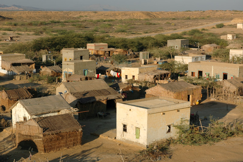
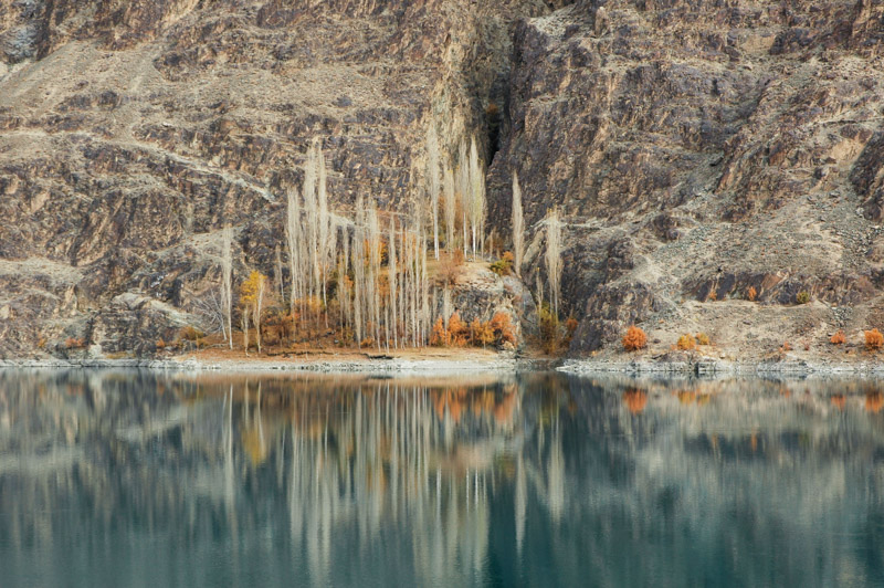
Mubarak Goth, Sindh, Pakistan
We follow a road between this low ridgeline and the Hub River, emerging at the village of Mubarak Goth on Soneri Bay, where we are welcomed by Abdul Rehman into his simple wooden home built a few hundred metres from a wide, magnificent sandy beach. In the afternoon we are taken out on-board his small fishing boat, a former lifeboat which he has purchased from the nearby ship-breaking yards at Gaddani and converted for fishing with an old diesel engine. We motor around the barren rocky mass of Charna Island, whose brilliant buttermilk-coloured rock contrasts vividly with the azure water of the Arabian Sea. Just thirty kilometres from the squalor of central Karachi, the area seems almost pristine. Way off to the west the Makran Range disappears into the haze of infinity, marking the beginning of a wild and barren coastline which spreads as far as Iraq.

Charna Island, Balochistan, Pakistan
We enjoy the evening in Abdul Rehman’s home, whose wooden plank walls allow a wonderful cool, fresh ocean breeze to permeate. He cooks for us at least four varieties of fish, fried in oil and sprinkled with salt and ground chilli, and I’ve never tasted better; delicious meaty white fish, straight out of the sea. Abdul Rehman is indeed one of the most disarmingly kind people I can ever remember meeting; despite being economically poor, he is unfalteringly generous, accommodating five of us, taking us out for the day, and feeding us a fantastic meal. He does this out of pure decency and hospitality, a kindness which touches us all.
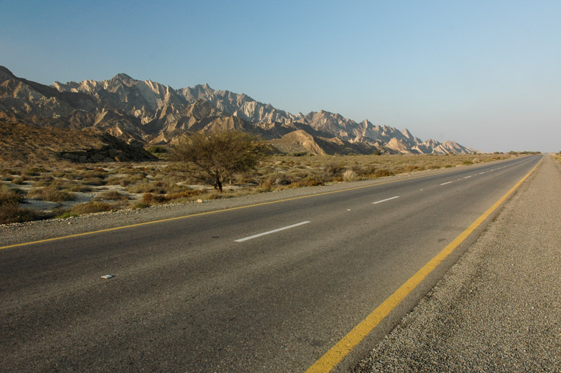
Makran Coastal Highway, Balochistan, Pakistan
The following day, we all drive together to a junction on the Karachi – Quetta Highway where I part ways with Aly, Shahana and Noé. They turn back eastwards to return to Hyderabad whilst I turn west, hoping to drive the length of Balochistan’s Makran Coast and possibly find an alternative border crossing into Iran from the usual point at Taftan, much further to the north. Despite the lure of more wild places to explore in a far corner of Pakistan, I’m sad to say goodbye to the family, having glimpsed yet more of the fascinating culture of Sindh; a place I am reluctant to leave.
The Makran coast is an intriguing area; officially off-limits to foreigners due to a perceived security risk, there is rumoured to be a brand-new Chinese-funded road running most of the way to the Iranian border. The area is almost complete wilderness, save for a few small fishing towns and an ancient Hindu pilgrimage site tucked away in the mountains. It is also historically notorious; for the loss of Cyrus the Great’s army in the sixth century BCE, when the area was known as the Persian satrapy of Maka (from which the name Makran derives), and then again in 325 BCE when Alexander the Great, who knew the place by the Greek name Gedrosia lost tens of thousands of men attempting to succeed where Cyrus had failed.

Hingol Valley, Balochistan, Pakistan
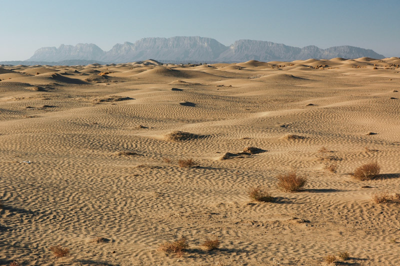
After a brief and unsuccessful attempt at obtaining a permit to visit the Makran, I decide to simply try and enter unannounced, hoping to take by surprise any police waiting at roadblocks. Crossing the Hub River into Balochistan, I pass through the chaotic industrial centre of Hub, home to much of the industry attached to Karachi, but soon enter the scrubby desert beyond, heading north towards the interior. The land is far poorer than the irrigated fields of Sindh; nothing but the occasional pomegranate farm and impoverished-looking Baloch herding camels and goats. With some trepidation, I take the turning onto the Makran Coastal Highway, encounter no problems with the police at the roadblock, and find myself on an arrow straight, perfect asphalt road. The landscape is utterly barren; a table-flat wasteland of thorny bushes, with the occasional camel’s footprint constituting the only signs of life. The sun is lowering in the sky, the road empty but for the occasional truck, and I have made my way into one of Pakistan’s more enigmatic destinations; conditions really couldn’t be better.

Beach, near Aghor, Balochistan, Pakistan
Soon, out of the hazy distance, the razor-sharp profile of the coastal range comes into focus a magnificent sight of twisted and gnarled rock, sliced into sharp erosional forms by freak rainstorms, and then preserved by the general aridity of the local climate. I turn off the road into the Hingol Valley, aiming to reach the cave sanctuary of Hinglaj, an ancient Hindu pilgrimage site, but sadly the road has been washed away by a recent flash-flood and the river remains a raging torrent of muddy water, making Hinglaj inaccessible. It’s easy to see however why the site has been revered for so long; set in a sanctuary of wall-like hills, with a freshwater source which creates a haven for wildlife such as urial and crocodiles. It’s fascinating to think that this is the most westerly holy site of Hinduism, the spiritual backbone of so many millions in the subcontinent.
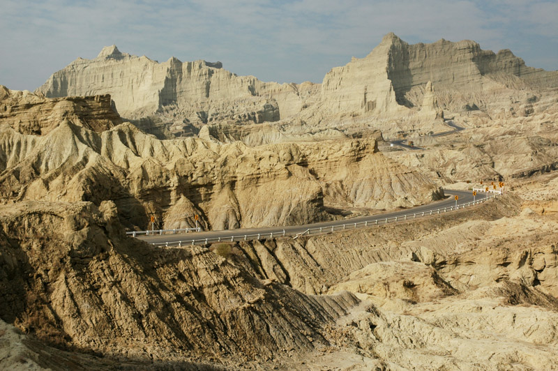
Buzi Pass, Balochistan, Pakistan
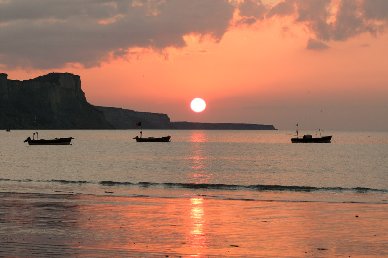
I spend the night in the tent on the back of the truck at a small roadside restaurant in the town of Aghor, pushing on early the next morning. The road soon starts to climb through a knot of dry mountains, truly other-worldly in their sharp, tortured forms. At one point the road draws level to the beach, and I stop to take a look. The beach is probably the best I’ve ever seen; kilometre after kilometre of perfect, clean golden sand dotted with the occasional piece of driftwood, and not a soul in sight. It’s mid December but the temperature is balmy and the water warm. It’s hard to believe one can find such perfection and have it all to one’s self. The road then enters more spectacularly eroded valleys, crossing the lunar landscape of the Buzi Pass then dropping down onto barren plains once more. I stop for lunch in the small coastal town of Ormara, a hideaway for the Pakistani Navy, and a number of Zikris; a maligned Baloch Islamic sect who have adapted their Islam to encompass and additional – Baloch – holy site of pilgrimage, and in doing so encounter the ire of some Sunnis. Ormara is a delightfully slow-paced place, but there’s little aside from the glorious beaches to detain a traveller, and I continue east towards Iran.
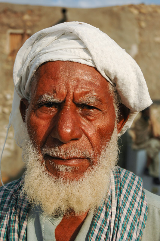
Baloch Man, Gwadar, Balochistan, Pakistan
Later in the afternoon I reach the town of Pasni, and just as I start to investigate the bazaar, I’m intercepted by two uniformed police on a motorcycle, who escort me to the tana (police station). Initially brusque, the police soon become friendly once they are satisfied that I am nothing more than an interested traveller, and offer me accommodation for the night. The faces here are an amazing mix of genes from all the nearby coastlines; some have typical Baloch features, but more common are those which are mixed, and there are clearly plenty of African and Semitic genes present; many look Yemeni or Eritrean and wear flowing white gowns perfumed with frankincense. In the evening I get speaking to the gentleman in the prison cell who tells me proudly that he is a gunman who fired at a government official, but missed. I tell him I’m heading to Iran, a country he is very keen to extol the virtues of. “Iran zabardast!” he shouts, and asks me jokingly if he can join me. He’s hardly the stereotype of a terrorist. The policemen staffing the tana turn out to be extremely friendly and hospitable; I’m given a bed for the night, and spend the evening drinking their contraband whisky.
Reluctantly, I have to take a police gunman along with me the following day for the drive to Gwadar, but it’s a better alternative than being sent back to Karachi. It rains heavily for the duration of the journey, stopping just before Gwadar, whose streets are nevertheless ankle-deep in water when I arrive. Once again, I stay at the tana and am escorted by two gunmen throughout the town. Gwadar was an overseas possession of Oman until 1958 and has a clear Omani influence, with the Sultan of Oman still retaining a large residence not far from the tana. Though little more than a large, fly-blown fishing village, Gwadar has a quite exotic air, with spices and fragrances giving the bazaar a more Middle Eastern flavour than others in the country, and faces which show a wide mixture of ancestry from South Asia, the Middle East and the east coast of Africa.
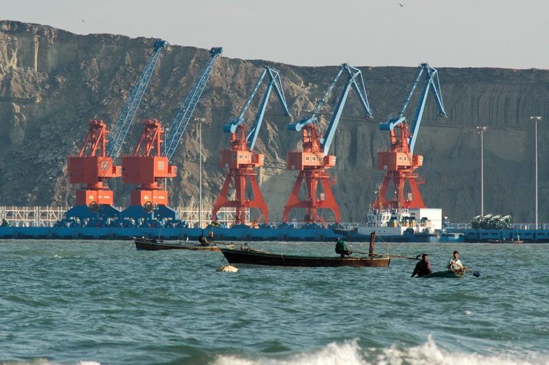
Deep Sea Port, Gwadar, Balochistan, Pakistan
Gwadar lies on a hammerhead promontory which pokes into the Arabian Sea, creating two long, pristine curving sandy coves which shelter a fleet of bobbing wooden fishing boats. On the west side of the headland comes the surprising sight of a deep-sea cargo port, fully constructed at an initial price of a quarter of a billion dollars by the Pakistani and Chinese government, freshly painted and ready to go, but starting to rust before the first ship has called in. The port was heavily funded by the Chinese government (and will be run by a Chinese corporation) as a warm-weather deep water port for receiving oil from the Persian Gulf, from where it can be driven the length of Pakistan and over the Karakoram Highway into China to meet the country’s ever-growing energy demand. Despite the massive revenue-potential for Pakistan, due to some political machinations, objections perhaps from the UAE or India, or just local administrative corruption and incompetence, Gwadar remains nothing more than a fishing village and economic backwater.
The only person back at the tana who speaks English is once again the gentleman in jail, who the police chief tells me is there for reasons of a family dispute; the man has fallen out with his father, who refuses to disclose the reason he left his biological mother. The chief of police then tells me he is also the man’s brother. The station master casually unlocks the inmate, who is perhaps in custody more for his own protection. Later, I am escorted by my gunmen out into the city, to a barber shop where I am able to take a much-needed shower (there are no facilities in the tana, even the drinking water comes from a rather unsavoury looking rainwater cistern). On the way back we stop for an impromptu smoke at a tyre repair shop where the owner burns a lump of opium stuck to a teacup with a hot metal rod, inhaling the vapours through a rolled up paper tube.
East Beach, Gwadar, Balochistan, Pakistan
Back at the tana I am approached by a member of the Inter-Services Intelligence (ISI), the murky and powerful national intelligence services who have various very murky dealings in surrounding countries, not least of all Afghanistan. The agent is a sincere and pleasant guy however, and for the first fifteen minutes persuades me that I should carry a gun, and seems thoroughly bemused by my assertion that it would be highly illegal (It is not unknown for the ISI to ‘lend’ foreign drivers automatic weapons for the crossing of Balochistan, where another agent collects them at the Iranian border). Steering the conversation away from firearms, I enquire about the border crossing into Iran at Mand, 250 kilometres away up desolate desert tracks. My suspicions are confirmed; there are no customs facilities at Mand and the border is closed to everyone except local residents. The only alternative is a 1750 kilometre round-trip via Quetta to the border crossing at Taftan, which is evidently the only Pakistan – Iran border crossing which foreigners may use.

Ras Koh Mountains, Balochistan, Pakistan
I set off on the long journey the next morning, managing to persuade my gunman to be dropped off at the edge of town, so that I may enjoy the return journey in solitude. Ordinarily I would be disgruntled at back-tracking hundreds of kilometres, but it’s such a meditative, restorative joy to drive on smooth, empty desert roads that I am frankly glad of it. I stop for lunch at a road-side restaurant near Ormara, and happen to say ‘asalaam aleikum‘ to a Pashtun lorry driver on my way in, only to find upon leaving that he had paid for my meal, without even saying a word to me. The kindness of people in Pakistan never ceases to amaze me.
I spend the night again at the restaurant in Aghor, then push on north in the morning, climbing away from the warmth of the coastal plain into the heavy cold of the desolate Balochistan mountains around Kalat. I arrive at night in friendly Quetta, which I decide is probably my favourite city in Pakistan with its incredibly friendly people; from the Pashtuns; big, ebullient, handsome people whom it’s hard to dislike, to the more reserved Hazara, the oriental-looking Uzbeks from northern Afghanistan, and some wiry Baloch, heavily outnumbered by Afghans in their own capital city.
Chagai Hills, Balochistan, Pakistan
I spend a day in Quetta buying spare parts for the truck from the city’s vast car-parts market, and head off along the long, empty road to Taftan. This is now the third time I’ve been along this frontier road to the Iranian border, the first being in fearful summer heat and the second under leaden skies which lashed down rain almost continuously. This time the skies are a perfect ultramarine, and the drive is very pleasant, passing the jagged contours of the Ras Koh Range, where Pakistan conducts its nuclear tests, and the soft, sculpted dunes which run north to the Chagai Hills, beyond which lie the wildest parts of Afghanistan, tantalisingly out of reach.
I spend the night in a surprisingly comfortable hotel in the wild Baloch town of Dalbandin, completing the final few hundred kilometres of asphalt to Iran. Close to the border the enormous snowcapped bulk of Mt. Taftan shimmers in Iranian Balochistan. The mountain gives its name to the squalid Pakistani border town, but it’s the first time the skies have been clear enough to see it from the road. I leave Pakistan with a nagging feeling of not having seen all I want, but it’s time to enter Iran and consider the future of my Odyssey.
Stage 12 – Pakistan: The Karakoram And Hindukush [2/2]
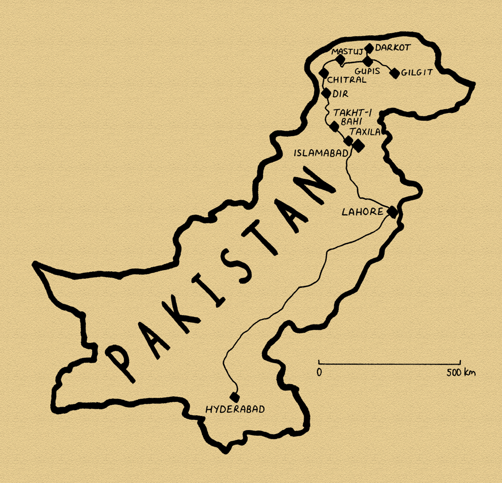 Having toured the very northern reaches of Pakistan, re-visiting places I regard the most beautiful in the world, I would now leave Pakistan’s Northern Areas, again retracing my steps from 2003 into the rugged northern reaches of the Hindukush on the romantically wild Northwest Frontier. Crossing the snow-covered Lowari Pass, I would drop down along the Afghan border, finally leaving behind the swath of mountains in which I had been travelling for the last six months, stopping at two-thousand year old sites which bear the traces of both the Buddha and Alexander the Great, before heading down into the balmy lowlands of the south, back to the gentle and alluring province of Sindh.

Polo Player, Gilgit, Northern Areas, Pakistan
On the 27th October I return to a deeply autumnal Gilgit, with dark blue skies casting yellowed trees in golden sunlight, picking out details of the grey-brown mountains and the sentinel minarets which puncture the skyline. Wafts of Turkestan greet the nose in Gilgit; a hint of the powdery smoke of burning poplar wood drifts down, as if it were carried by a breeze off the Pamirs from Kokand or Kashgar, and mixes with the smell of the spices and squalor of the Subcontinent, into a town which is a fusion of both South- and Central Asia, and is one of my favourite. It’s a retreat in the mountains, respite from the searing, dusty banks of the Indus, green with water coursing down from the Hindukush. I spend almost two weeks relaxing in the Madina Guesthouse, enjoying the company of other travellers and cooking meals for myself after rather tiring of the greasy and bland fare of northern Pakistan. As the leaves begin to fall from the trees I finally make the push to return to Islamabad, not on the Karakoran Highway, but via Chitral, deep in the Hindukush of the Northwest Frontier.

Burusho Woman, Darkot, Yasin Valley, Northern Areas, Pakistan
I leave Gilgit with Knut, a Norweigan NGO worker who has lived in Afghanistan and Somalia, and head east up the Ghizer Valley, passing the 1900 year-old Buddha carving on the cliffs at Karga Nala. The deep, metallic blue waters of the Gilgit River are complemented by the autumnal poplar and walnut trees, whose leaves are being grazed by cows. We pass the village of Gakuch, where the Ishkoman Valley marks the boundary between the Karakoram and Hindukush ranges, to the town of Gupis where we head north into the former princely state of Yasin. The valley is heading into winter; the trees are bare, the fields barren, and smoke climbs slowly into the thick, cold air. At the end of the valley lies the rambling village of Darkot, set within an amphitheatre of dunn, red-grey mountains and bare potato fields. A glacier tumbles down to the village edge from the west, a reminder that the surrounding peaks are deceptively high. The people of Yasin are Burushashki speakers (as in Hunza, the only other place where the language is spoken), and are friendly and welcoming. Many of the children have distinctly European features, striking red hair and green eyes. Older women here wear either the standard topi, similar to that work by Tajiks in the Chapursan Valley, or an unusual tall, tapering skullcap which I’ve not seen anywhere else. We are accommodated in the house of the local schoolteacher, Murat, who produces a hearty meal of dal with bread and carrots, and salty, goaty tea, which we eat whilst his father sniffs our water bottles hopefully for alcohol. Murat bemoans the state of the tourism industry in Pakistan; fewer than forty tourists per year visit the valley by his reckoning.
Khaltsi Lake, Northern Areas, Pakistan
We leave Darkot the following afternoon, overnighting in a hotel in Gupis which I had stayed in five years earlier, then continue west, past the mirror-like Khalti Lake. The Ghizer Valley then widens and becomes increasingly barren, opening up into dormant sepia landscapes at Phander, then winds up the broad but rough Shandur Pass, passing donkeys laden with wood to heat homes through the long winter; a sure sign of impending snows. The broad and open Shandur Pass, renowned as the world’s highest polo ground, is thankfully for the moment totally free from snow and yaks still graze on yellowing grass on the far shore of a lake, giving the scene a Central Asian, Pamiri feel.
Beyond the pass we descend into the wilds of the Northwest Frontier Province (NWFP), where bushy beards and Chitrali caps mark our entrance into the Sunni Khowar-speaking area. Passing the enticing entrance to the Yarkhun Valley, which runs up to the Afghanistan border (somewhere I have to save for a future visit) we spend the night in the village of Mastuj, then descend the following morning through Bunji on rough roads to the town of Chitral, which is engulfed in low clouds bringing rain and causing the whole town to be covered in mud. A gap in the clouds one evening gives a glimpse of the distant snowcapped peaks of 7709 m Tirich Mir, but otherwise the weather precludes any great views of the Hindukush.

Lowari Pass (3125 m), North West Frontier Province, Pakistan
All the rain means snow up in the mountains, which poses a problem as there is one final mountain pass to cross before descending to the lowlands. We wait in Chitral for two, and then three days, getting mixed information on the state of the pass. On the fourth morning it is rumoured that the pass has been cleared by bulldozer, which triggers a mass exodus of 4x4s. The pass has indeed been cleared, and the snow compacted into a few centimetres of ice so slippery it is difficult to walk on. We slowly creep up the pass in four-wheel-drive, passing numerous stranded vehicles and waiting for lorries to negotiate the switchbacks on their way down to Chitral. Finally, after more than twenty treacherous, icy switchbacks we reach the pass at 3100 m, where we are delayed until after sunset by broken down lorries and incompetent drivers.
It is dark by the time we reach the first town of Dir, which is considered unsafe due to a strong local Taliban element. Knut wanders out to speak to the police, who are holed-up in the police station with an impressive array of weaponry. We are directed to a nearby hotel, though the police are unwilling to leave the station after dark. I park the car and the two of us are taken to the top floor of the local hotel, where we are advised to stay away from the windows, and have our evening meal brought to our room. I spent an afternoon in Dir in 2003, and remember for no particular reason feeling rather uneasy, something which is now more easily explained.

Buddha Statue, Takht-i Bahi Monastery, North West Frontier Province, Pakistan
We leave Dir the next morning through terraces fields, following the Panjkora Valley down through Malakand down towards Peshawar, making a detour at Mardan to visit the spectacular ruins of Takht-i Bahi, a 1st Century BC Parthian Buddhist monastery complex, which lies spread across a number of low hills amidst the sugar-cane fields north of the Indus. One doesn’t usually associate Pakistan with Buddhism, but it in fact has some of the world’s earliest Buddhist remains, dating to a period where Buddhism was spreading west from the north of the subcontinent, into the Hindukush and into Central Asia (and subsequently Tibet, Mongolia and as far as Japan as the Mahayana, or Tantric school of Buddhism). The area known as Gandhara, in the current day area of north-western Pakistan and eastern Afghanistan, was where Buddhism met the Hellenic-influenced cultures which had emerged from the fragments of Alexander the Great’s Seleucid Empire. The result was the unique cultural syncretism now know as Greco-Buddhism, which produced some of the earliest surviving representations of the Buddha whose Asian features have a distinctly Mediterranean look about them. The well-preserved 1900 year-old remains of the monastery complex are a UNESCO World Heritage Site, yet we are the first foreign visitors since June – five months earlier.
In the nearby village of Shahbaz Gahri is a rock which bears one of the famous edicts of the Mauryan king Ashoka. Carved in the 3rd Century BCE, the Brahmi inscriptions preach the social and moral precepts of a king whom, appalled by his own violence early in his life, went on to foster the peaceful spread of Buddhism across the subcontinent.

Ashokan Inscription, Shahbazgahri, North West Frontier Province, Pakistan
Following a spate of deadly recent bombings, and the murder of a US aid worker just days earlier, Knut and I decide to avoid Peshawar (I will visit it next year) and head straight for the capital Islamabad. We join the M1 motorway, which after the rough mountain tracks of the north, is a paradise of smooth asphalt. With strict rules keeping out pedestrians, donkey carts and motorcycles, and keeping out encroaching traders, and with some semblance of orderly traffic rules, the motorways of Pakistan are a remarkable achievement; one of the few things in the country which really ‘work’. Only the Pashtuns pulled up at sunset prostrating themselves on prayer mats on the hard shoulder remind me that I’m in Pakistan and not the UK.
I spend a number of days in the Tourist Campsite in Islamabad, meeting other overland drivers and travellers and obtaining an Iranian visa for the onward journey to the Persian Gulf, from where I plan either to cross to the UAE on a ferry, heading west through Oman and Yemen to Africa, or to cross southern Iraq to Kuwait and on through Saudi Arabia.
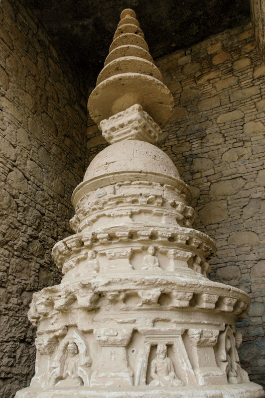
Stupa, Mohra Muradu, Punjab, Pakistan
A few kilometres west of Islamabad lies another World Heritage Site, the archaeological complex of Taxila, which encompasses numerous stupa mounds, temples and monastery complexes from the early centuries of Buddhism, excavated by the British in the early 20th Century. Various sites are scattered around the surrounding villages, over a considerable area which speaks of once being a great meeting place of west and east more than 2000 years ago. In the village of Mohra Moradu, in a vast, paved mound lies a distinctive multi-tiered stupa surrounded by delicately carved figures of the Buddha in meditation, while at the temple of Jandial lie the bases of a number of Ionic Greek columns, a poignant reminder of the exploits and influence of a single young man, more than 2300 years ago. Though like so many of the country’s attraction, Taxila today is a backwater little known to the outside world, it must have been around here that Alexander’s war-weary troops finally set eyes on the bountiful plains of India eight years after crossing the Hellespont.
Islamabad, Pakistan’s capital since 1962 can sometimes seem a little bland and characterless, with regular, planned streets of modern architecture. But in amongst the city’s order lie mess and chaos, aromas of food and filth, and a kaleidoscope of people from swarthy Pashtuns to strolling Chinese expatriates, which give the city some charm, especially in the frenetic marketplaces at the centre of each city block. Islamabad is never an unpleasant place to stroll; one moment I’m in suburban America on streets of large, comfortable houses behind well-tended hedges (and with a shotgun-toting guard sat on a plastic chair), the next I’m walking down a leafy tree-lined Tashkent boulevard with huge, slab-sided buildings and uneven pavements.
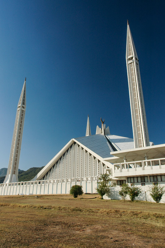
Shah Faisal Mosque, Islamabad, Islamabad Capital Territory, Pakistan
The city indeed has whiffs of gigantism, from Soviet-style federal offices to the neo-Mughal Supreme Court and presidential residence, to the pure 1970’s Gulf oil-boom architecture of the vast and imposing Shah Faisal Mosque. For all the squalor, noise and filth of most Pakistani cities, Islamabad, with the tumbling greenery of the Margalla Hills as a backdrop, is a surprisingly likeable place to spend some time. Once I have my Iranian visa however, I move south, stopping first in Lahore and then driving the 1100 km overnight down to Hyderabad.
Leaving Lahore around midnight, dawn breaks somewhere in rural Punjab. Dawn in the Punjab is quite spectacular. From the darkness, the first light brings silhouettes of the timeless agricultural landscape; mango trees in grassy fields of corn, rice and sugar cane. Shapes appear out of the thick morning mist, which mixes with the dust in the air. Brick-kiln chimneys issue a steady stream of black smoke, which sits in a flat stratum and hangs immobile until gently streaming off in the early air currents. The landscape burgeons – every square metre is devoted to a carpet of crops – this is truly the agricultural heartland of Pakistan. Near Bahawalpur, I cross the Sutlej, a small, stagnant slick of murky water, a reminder of the pressure which such vast agriculture puts on water resources, and a depressing sight when compared to the raging torrent which cuts a near-vertical gorge through the lower Himalaya, forming the Kinnaur Valley.
Once across the provincial boundary into Sindh, the atmosphere changes immediately; gone are the noxious industrial cities of Punjab, replaced with endless towns and villages set amidst vast farmlands. The edgy atmosphere of religious posturing in Punjab is replaced by the more spiritual and easy-going Sindhis. Exquisitely tiled shrines appear amongst the palm trees, giving an exotic, mystical atmosphere, and there is a pervading, almost African sloth. I’m reminded of how taken I was with the gentle, unhurried people of this charming backwater, and look forward to arriving at Aly and Shahana’s place in Hyderabad.
Stage 12 – Pakistan: The Karakoram And Hindukush [1/2]
 In the summer of 2003 during my first visit to Pakistan, I was mesmerised by the beauty of the mountainous north, where the Himalaya, Karakoram and Hindukush ranges meet around the tributaries of the Indus river as it flows out of India. Despite having spent already several months in the mountains, tracing the Himalaya west from Sikkim to the very edge of Ladakh, it was with eager anticipation that I returned to Pakistan with the thought of seeing places that five years earlier, I had regarded as being the most beautiful I’d ever seen. I hoped to recapture some of the magic I’d felt that summer when I had first encountered Asia.

Fakir, Lahore, Punjab, Pakistan
On the afternoon of the 5th September 2008 I leave India for the last time on this trip, and plunge back into the shambolic Punjabi city of Lahore which I’d left six months earlier. My spirits lift with a sense of relief and homecoming as I re-enter Pakistan after months in India. A great rainstorm gathers above the city as I leave the border crossing, plunging the day into twilight, whipping up dust and litter, and finally unleashing a deluge of rain which quickly floods the overcrowded streets and cools the air pleasantly. It’s the end of the monsoon season, which after a few weeks should bring clear skies and stunning vistas in the northern mountains.
I spend three weeks in Lahore, during which time I rebuild the front axle of the truck which has taken quite a pounding off-roading in Ladakh, and replace my now completely full passport for an outrageous price at the British High Commission in Islamabad. I also spend some time exploring the city, which has become distinctly less pleasant than I remember from my first visit in 2003. Traffic has reached saturation point and beyond; so thick and out of control that one may often wait several minutes at the roadside in order to flee across the lanes when the smallest space permits. Some palms have been greased to allow the Qingqi, a horrendous bastard hybrid of a cheap motorcycle and metal bench which is the noisiest, most uncomfortable and unsafe mode of transport I have come across, one which many see as another sign of regression into deeper economic backwardness. Only occasionally in the city may one get a whiff of Jasmine or a hint of cardamom wafting in the narrow lanes, above the near continuous stink of raw sewage, rotting chicken entrails, human excrement, horse shit, burning garbage, oily two-stroke exhaust fumes and human sweat. While the cities of Indian Punjab, among the richest of the Subcontinent, become slowly cleaner, more orderly places, Lahore is gently slipping into chaos and breakdown. The great architecture of the old city; the rambling Fort, the crumbling formerly Hindu traders’ mansions, the narrow bazaar streets and the opulent colonial-era buildings of The Mall all remain, but these days are the exception rather than the rule.
One place however stands out in Lahore as an oasis of calm; the magnificent red-brick Badshahi Mosque. Built by the sixth Moghul emperor Aurangzeb, it was the world’s largest mosque from its completion in 1673 until 1986. Its eight crimson minarets with delicately carved canopies, and its three vast, spiked white marble onion-domes pick out a silhouette against the warm evening whichevokes all the lost grandeur of the subcontinent from the pages of Kipling’s novel Kim.
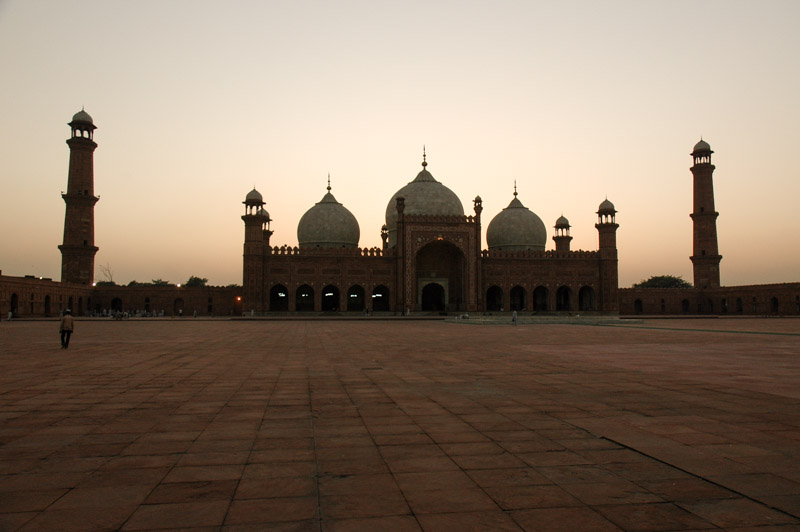
Badshahi Mosque, Lahore, Punjab, Pakistan
Nao joins me once more from India towards the end of the three weeks, and together with a British motorcyclist Andy, whom we meet in the infamous Regale Internet Inn, we head north by way of Islamabad towards the cool air and clear skies of the mountains. We take a slightly convoluted route through an area of hill stations known as the Galis, an area famous among Pakistani’s for resort towns such as Muree and Nathia Gali which, although set amongst pleasant rolling green hills, are but the very outliers of the sublime mountain ranges to the north. We are refused entry to Azad Jammu & Kashmir, the Pakistani-administered section of the Vale of Kashmir, and instead find ourselves for the night in the uninteresting and unpleasant junction town of Mansehra.
From Mansehra the following day we begin our ascent into the mountainous Kaghan valley, the lower reaches of which were heavily damaged by an earthquake in 2005. As we climb above two thousand metres the scenery becomes pleasantly alpine and highly reminiscent of the Swat Valley, with pine-clad mountainsides flanking the fast, blue Kunhar River. We camp overnight at the edge of the town of Kaghan, in meadows of budding marijuana plants, and the following day make a side trip from the town of Naran up an extraordinarily bumpy track to the magnificent Saiful Muluk Lake at 3220m, whose still, blue surface perfectly reflects the surrounding amphitheatre of mountains.
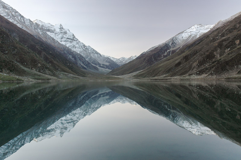
Lake Saif-ul Muluk, North West Frontier Province, Pakistan
Above Naran the valley begins to opens up, but becomes more sparsely populated. In the village of Burawai however, our progress ends. A speeding lorry has destroyed the bridge, which is still sticking out of the water alongside a half submerged bulldozer which has failed to cross the river. The Army have been deployed (for this is a sensitive region close to the disputed Indian border), but it is clear that it will be a long time before anything is fixed.
Locals suggest that an alternative, small wooden bridge a few kilometres down the road would be suitable for my car, and which after passing through a small village, would rejoin the main highway just beyond the collapsed bridge. Not wishing to undertake a backtracking detour of almost 400 km, I opt to take the bridge, which very nearly ends in disaster. The bridge is constructed from nothing more than tree trunks, which are not in any way held together. As I tentatively make my way onto the bridge, the rear wheels spin, bunching up the logs until the wheels dangle freely above the two main supports and the thrashing water just below. Trying to extricate the car using four-wheel-drive makes the situation worse, and ends with the front right-hand wheel dangling on the edge of the bridge. The river is not far below, but is full of large boulders and running extremely quickly.

Hinko Man, Naran, North West Frontier Province, Pakistan
I start to unpack the car to reduce its weight, and locals, held up by my stranded car, come to assist. Over the next hour or two, with their eager help, I jack the truck up in each corner and reassemble the bridge under its wheels. The ‘best driver in the valley’ is called to try to move the truck, but after seeing its precarious position refuses to get in. Finally, with a crowd of perhaps twenty, a line is attached to the front of the truck and very carefully, in four-wheel-drive, and staying clear of the brakes, I tractor the car across the log bridge and, elated, make it to the far side. The locals then tell me that the same thing happened last week, and that the rescue operation took the entire day.
The track through the village is tiny, and designed for smaller Jeeps, but I make it through with only a couple of scrapes, come down a steep and rough track which overlooks the bend in the river with the stricken bridge, and I am finally back on the road, shaken, but thrilled. It is by now getting late and cold, and we ask a nearby Army captain about finding a place to stay. Ali is a mild-mannered and well-spoken Sindhi from Karachi, a refreshing oddity in an organisation which is almost exclusively Punjabi. He immediately offers us a place in the captain’s mess in the nearby town of Battakundi. Andy and I leave our vehicles with some of his officers who will be staying in tents at the roadside, and set about crossing the river again. This involves clambering over the rubble and wreckage which is lying in the river, and climbing onto the stranded bulldozer. One of Ali’s officers on the far side of the river then drives an enormous earth-mover half into the river as far as he dares, and we jump into its enormous steel bucket. He then lifts the bucket and deposits us carefully on the far side of the river like a lioness setting down her cubs by the scruffs of their necks.
The captain’s mess is extremely comfortable, and we are waited on by his officers like esteemed visitors. Ali appreciates the beauty of his surroundings, but misses his native Sindh (as do I). The local Kohistanis who live above Burawai and beyond the the pass at the head of the valley are hostile to outsiders, and their children are renowned for stone throwing which Ali warns us about. Having a crew of officer’s at his disposal, Ali is able to have the children rounded up and given a good thrashing as a deterrent to stoning the Army.

Babusar Pass (4100 m), North West Frontier Province, Pakistan
After an unexpected night of comfort and good company, we cross the river one final time in the morning, and wishing Ali well with his work here, continue our journey north. As we make our way up the valley, the scenery becomes starker, passing the glacial water of Lulusar Lake and finally reaching the 4100 m Babusar Pass, with monochrome views over a huge, uninhabited upland area strewn with glacial moraines. The pass marks the border of Pakistan’s Northern Areas, a region not formally incorporated into the state of Pakistan, claimed by India but administered by Pakistan since 1947. We descend on the north side of the pass, attracting the inevitable hail of stones from the native Kohistani boys (I remind myself to bring a slingshot on the next trip), to the town of Chilas which lies in an impressively barren bend in the Indus river valley, on the famous Karakoram Highway.
The Karakoram Highway, or KKH was completed in 1979 and was an audacious engineering mega-project to cross the India subcontinent – Eurasia collision zone and link China and Pakistan by means of the 4700 m Khunjerab Pass, opening-up some extremely isolated mountain valleys which had previously only been seen by explorers and mountaineers. It follows the Indus River north to Nanga Parbat, then the Hunza River still further north through the Karakoram, passing the Tajik-speaking valleys of Gojal all the way up to the Chinese border where it skirts the Pamirs down to the historic Silk-Road oasis of Kashgar. Owing to the restrictions and expense of driving one’s own vehicle into China, my north-bound journey will end at the border.

Pakistan – China Border, Khunjerab Pass (4700 m), Northern Areas, Pakistan
Passing the 8,126 m high mass of Nanga Parbat, the ninth highest mountain in the world, we (Andy and I; Nao has gone ahead to the Hunza Valley) reach the friendly Shina town of Gilgit, located just off the KKH. At the police checkpost on the edge of town, I befriend two Belarussian telecoms engineers who invite me for Belarussian vodka in the town’s best hotel, where I am joined by Englishman Karl, a part-time chef and perennial long-term traveller. We drink vodka out of clear water glasses, and talk of Belarus and the former USSR – a rather culturally disorienting conversation in this remote and conservative mountain town.
I meet Nao again in Karimabad further up the KKH, and we travel for a few days together via Passu to Sost, the last town in Pakistan. Here she leaves on a minibus to China where I cannot follow; it is the last time we see each other.
Although I have crossed the pass five years ago, I decide to drive up to see it once again. The road twists through harsh and rocky terrain, climbing past the yawning Koksil Valley, high, desolate and uninhabited but for a few Marco Polo sheep. Clouds start to roll down as I approach the pass, the wind is fierce and the temperature freezing. After a cup of tea with the friendly border guards who live a pretty grim life up on this windswept pass, I return to Sost and regroup with Andy and Karl.

Wakhi Tajik Woman, Yarzrich, Chapursan Valley, Northern Areas, Pakistan
The magic of northern Pakistan and the KKH is partly the stupendous scenery, but also the diversity of people who live in the myriad isolated valleys which the KKH connects. The following day the three of us venture into the Chapursan Valley, nestled in the very north of Pakistan, which runs into the Wakhan Corridor of Afghanistan. The pastel grey-brown valley consists of scattered villages where yellowing poplar trees mark potato fields and polo grounds, surrounded by high and impenetrable mountains on three sides. The local Wakhi people are extremely welcoming despite the simple conditions of their existence, and invite us in for tea in the village of Yazrich. Strikingly fair-skinned and European-looking, they are believed to have migrated from northern Afghanistan into the region several centuries ago. The houses are similar in style to those of the Pamir region of Tajikistan, with four separate living quarters surrounding a central seating area, and roofed with wooden beams in a distinctive concentric octagonal pattern. Rather than being chronically timid or simply absent, the local women would engage in conversation, however limited by language, a refreshing change after a month of speaking only to men. We finally reach the last village in the valley, Zuud Khun and the charming guesthouse of the ebuillient Alum Jan, a gentle giant of a man who more resembles an Amerindian than a Pakistani. The village is fantastically tranquil and bucolic, and I spend three pleasant autumn days walking here and unwinding.
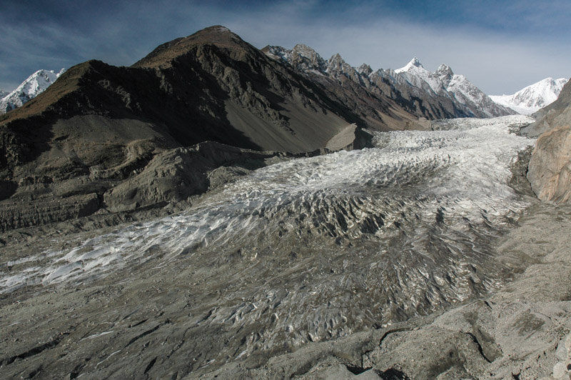
Passu Glacier, Northern Areas, Pakistan
My next stop is the roadside village of Passu, consisting of just a few shops and hotels, located on the east side of a vast 7500 m Karakoram massif, the most impressive stop on my 2003 trans-Asia journey, and possibly my favourite spot on Earth. Walking a little way south of Passu village, one climbs the terminal moraine of the Passu Glacier, walks up its left-lateral moraine, then further up a treacherous scree-slope into the Yunz Valley, which is inhabited seasonally by shepherds who live in rudimentary stone huts with their flocks. From the edge of the Yunz Valley one has an unobstructed vista of the calving white seracs of the cascading Passu Glacier, which winds down in an impressive swathe from the huge, glaciated massif. Climbing still further from the Yunz Valley to a ridge named Golden Top, which sits at 3400 m, one thousand metres almost directly above the village and the KKH, one gets a 360º panorama of some of the world’s most impressive mountain scenery. At one’s feet unfolds over 20 km of the 57 km long Batura Glacier, a vast tongue of ice which is one of the world’s longest non-polar glaciers, and in its lower reaches is a carpet of grey ice and moraine, only revealing a core of clean white ice further up in the centre of the glacier.
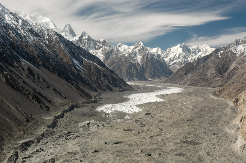
Batura Glacier, Northern Areas, Pakistan
The day is warm and pleasant, and sharp, delicate cirrus clouds spin an ethereal blanket in the turbulent air currents above the massif, mirroring the glacial forms below. The Hunza River flows alongside the KKH far below me, where occasional vehicles pass silently, unknowingly along the terminal moraine of the glacier. Not a soul moves in the valley at my feet, and there is silence but for the occasional groaning of calving ice. On the opposite bank of the Hunza river from the village are barley fields punctuated with yellowing polars, reached by precarious-looking wire bridges which sag just above the frothing glacial water. Beyond this thin strip of agriculture lies an impressive wall of rock; the Cathederal Peaks, a jagged, sharp wall of five to six thousand metres which looks not unlike whipped peaks of meringue. It’s hard to imagine anywhere more beautiful.

Cathedral Peaks, Passu, Northern Areas, Pakistan
Seeing such sublime scenery, under the crisp, cerulean-blue autumn skies is an experience which far transcends words or description. One could spend hours, days, months perhaps just admiring the view, contemplating the scale, beauty, silence and power of such an awesome view. It is an experience which will stay with me my entire life, one with which all others may be put into perspective, one which defines and fulfils the basic urge to travel, and see, and know.
Passu is a paradise for hikers and trekkers, though like everywhere in northern Pakistan, it sees virtually no tourists. Pakistan’s fledgling tourist industry was killed by the events of September 11th 2001, and is dealt further blows with heightened turmoil in the country. This leaves just a small clique of travellers who visit the country, male members of which generally agreeing that it’s their favourite.

Rakaposhi (7788 m), Karimabad, Hunza Valley, Northern Areas, Pakistan
Fifty kilometres down the KKH on the south side of the massif in Hunza proper, lies the charming hillside town of Karimabad. Not quite as spectacular as Passu, Karimabad has a eagle’s eye view of the stupendous Hunza Valley, and is arguably even more picturesque, with its swathes of greenery either side of the Hunza River. To the north, a huge cleft in the massif reveals a glimpse of the Ultar icefall; a tumbling glacier which looks like a colossal frozen waterfall. Sitting at the base of this defile is the impressive Baltit Fort, where the Mirs of Hunza lived until 1945, and whose architecture has elements of the Moghuls and Tibet. Rakaposhi, at 7788 m sits to the south-east and completes the magnificent surroundings of the town. As in Passu the autumn light is magnificent; the world seems to be caught in freeze-frame between the frenzy of summer and the bleakness of winter, a sea of riotous colour etched in gorgeous cool light.

Shyok River, Khapalu, Northern Areas, Pakistan
Sadly the town itself is not in such a splendid state; a hotel boom which was killed by the events of September 11th 2001 has left dozens of half-finished buildings, bristling steel reinforcement rods and dangerous, sagging wiring. The steep main street is a muddy mess of concrete rubble and broken asphalt up which labouring minibuses and Jeeps grind in clouds of smoke. The local Burusho people – who speak an intriguing language isolate unrelated to any known language – are extremely pleasant and tolerant, but the practice of marrying first cousins in such a small community has a clear effect on the demographic; at times it seems like half the population on the streets are lunatics, shouting at the sky, walking with a sleepwalker’s trudge,, wheedling for food at the village’s eating stalls. Nevertheless, the squalor does little to detract from the overall setting.
In Gilgit once again, Andy, Karl and I regroup and head off east, passing the northern flanks of Nanga Parbat on the KKH, then joining the Indus once more and driving upstream into Baltistan, the Indian-controlled side of which I had driven through with Nao two months earlier. The road teeters high above the river, winding through tight mountain valleys until reaching a large, open area along the riverside close to the town of Skardu. Beyond the town the valley is wide and filled with alluvium, and the Indus a deep turquoise, looking very much as it did in Ladakh. Beyond the pleasant Balti town of Khapalu, we reach the furthest point on the road towards the disputed Indian border that foreigners are permitted to travel on, and then head north into the Hushe Valley.

Machulu, Hushe Valley, Northern Areas, Pakistan
Deep in Baltistan, the Hushe Valley is one of two approaches into the highest reaches of the Karakoram, where K2, the world’s second highest peak sits at the head of the Concordia Glacier in an area known as the ‘Throne-room of the Gods’. Sadly it is too late in the season to go trekking, but the valley is still open and accessible. The rough road up the valley passes in its lower reaches through neat and even elegant settlements such as Machulu, which consists of a central mosque surrounded by squat one and two-storey whitewashed houses of strikingly Tibetan form, amidst yellowing poplar and apricot trees.
When we arrive at the head of the valley however, in the village of Hushe, the impression is very much less elegant. Hushe is the most hopeless and squalid place I’ve seen for a long time, a muddy slum of collapsing stone hovels, like a medieval European forest camp. The people are filthy and stand slightly menacingly, staring at us coming into the village. A pack of the most wretched-looking feral children appear, with grubby brown snot-smeared faces, a multitude of skin conditions, all adorned in filthy rags, their genetically anonymous faces suggesting a particular dedication to inbreeding. Andy, who arrives before Karl and myself maintains that he saw a man getting out of bed with a sheep’s head; there are children with bloated heads, three ears and growths around their mouths. We take a grubby room in the village’s only guesthouse, but opt to cook our own food after seeing the ‘kitchen’; a filthy, greasy black hole. With Karl along (a professional chef), and the full kitchen dragged out of the back of the truck, this is by no means a hardship.

Shigar Valley, Northern Areas, Pakistan
Despite the squalor of the village, the surroundings are magnificent; 7821 m Masherbrum sits at the head of the valley, and the nearby Humbrok Valley is just beginning to freeze over for the winter. The snow however restricts our options for trekking, meaning we leave the Hushe without even a view of K2. On the way back to Skardu, we pass the magnificent and yawning entrance to the Shigar Valley, where the Indus River becomes wonderfully braided, flowing across a plain of fine alluvium which the wind has whipped in places into towering sand dunes, somewhat incongruous in this rarefied mountain setting.
From Skardu Andy and I say farewell to Karl (I will meet him again in the UK in 2012), and drive south, climbing onto the Deosai Plains, a huge Himalayan wilderness of rolling grassland at 4000 m, which stretch west as far as the Babusar Pass and Kaghan Valley, and east as far as the disputed Indian border close to the town of Drass. The views are immense, of endless yellowing grass, framed by distant peaks in troubled Kashmir. Streams criss-cross the plains, requiring river crossings and at one point driving over a rickety suspension bridge, before descending north-west towards Nanga Parbat, the westernmost outlier of the Himalaya.

Nanga Parbat (8126 m), Northern Areas, Pakistan
Andy and I reach the village of Tarashing late one evening, and the following morning I trek up through Shina and Kohistani villages to the moraine of the Tarashing Glacier, beyond which, just a few hundred metres away is the Rupal Face of Nanga Parbat; a four thousand metre vertical wall of rock which is almost incalculably vast-looking at this proximity. Nanga Parbat is the western anchor of the Himalaya; to the north of the Indus lies the Karakoram Range, while to the west, beyond the Indus and Hunza Rivers, lies the Hindukush.
The mountain marks the end of a six-month traverse of the Himalayas, starting back in Sikkim at Kanchenjunga in May, and moving gradually west through Nepal, Ladakh and Kashir. Had I found the same magic this time as that which so impressed me in 2003? Well, surprisingly yes. But I never found anything to beat that spot high above the village of Passu. Now winter is fast approaching, and thoughts begin to return to the warmth of the lowlands.
