
Stage 12 – Pakistan: The Karakoram And Hindukush [1/2]
 In the summer of 2003 during my first visit to Pakistan, I was mesmerised by the beauty of the mountainous north, where the Himalaya, Karakoram and Hindukush ranges meet around the tributaries of the Indus river as it flows out of India. Despite having spent already several months in the mountains, tracing the Himalaya west from Sikkim to the very edge of Ladakh, it was with eager anticipation that I returned to Pakistan with the thought of seeing places that five years earlier, I had regarded as being the most beautiful I’d ever seen. I hoped to recapture some of the magic I’d felt that summer when I had first encountered Asia.

Fakir, Lahore, Punjab, Pakistan
On the afternoon of the 5th September 2008 I leave India for the last time on this trip, and plunge back into the shambolic Punjabi city of Lahore which I’d left six months earlier. My spirits lift with a sense of relief and homecoming as I re-enter Pakistan after months in India. A great rainstorm gathers above the city as I leave the border crossing, plunging the day into twilight, whipping up dust and litter, and finally unleashing a deluge of rain which quickly floods the overcrowded streets and cools the air pleasantly. It’s the end of the monsoon season, which after a few weeks should bring clear skies and stunning vistas in the northern mountains.
I spend three weeks in Lahore, during which time I rebuild the front axle of the truck which has taken quite a pounding off-roading in Ladakh, and replace my now completely full passport for an outrageous price at the British High Commission in Islamabad. I also spend some time exploring the city, which has become distinctly less pleasant than I remember from my first visit in 2003. Traffic has reached saturation point and beyond; so thick and out of control that one may often wait several minutes at the roadside in order to flee across the lanes when the smallest space permits. Some palms have been greased to allow the Qingqi, a horrendous bastard hybrid of a cheap motorcycle and metal bench which is the noisiest, most uncomfortable and unsafe mode of transport I have come across, one which many see as another sign of regression into deeper economic backwardness. Only occasionally in the city may one get a whiff of Jasmine or a hint of cardamom wafting in the narrow lanes, above the near continuous stink of raw sewage, rotting chicken entrails, human excrement, horse shit, burning garbage, oily two-stroke exhaust fumes and human sweat. While the cities of Indian Punjab, among the richest of the Subcontinent, become slowly cleaner, more orderly places, Lahore is gently slipping into chaos and breakdown. The great architecture of the old city; the rambling Fort, the crumbling formerly Hindu traders’ mansions, the narrow bazaar streets and the opulent colonial-era buildings of The Mall all remain, but these days are the exception rather than the rule.
One place however stands out in Lahore as an oasis of calm; the magnificent red-brick Badshahi Mosque. Built by the sixth Moghul emperor Aurangzeb, it was the world’s largest mosque from its completion in 1673 until 1986. Its eight crimson minarets with delicately carved canopies, and its three vast, spiked white marble onion-domes pick out a silhouette against the warm evening whichevokes all the lost grandeur of the subcontinent from the pages of Kipling’s novel Kim.
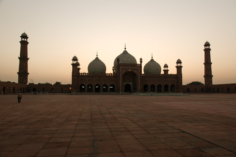
Badshahi Mosque, Lahore, Punjab, Pakistan
Nao joins me once more from India towards the end of the three weeks, and together with a British motorcyclist Andy, whom we meet in the infamous Regale Internet Inn, we head north by way of Islamabad towards the cool air and clear skies of the mountains. We take a slightly convoluted route through an area of hill stations known as the Galis, an area famous among Pakistani’s for resort towns such as Muree and Nathia Gali which, although set amongst pleasant rolling green hills, are but the very outliers of the sublime mountain ranges to the north. We are refused entry to Azad Jammu & Kashmir, the Pakistani-administered section of the Vale of Kashmir, and instead find ourselves for the night in the uninteresting and unpleasant junction town of Mansehra.
From Mansehra the following day we begin our ascent into the mountainous Kaghan valley, the lower reaches of which were heavily damaged by an earthquake in 2005. As we climb above two thousand metres the scenery becomes pleasantly alpine and highly reminiscent of the Swat Valley, with pine-clad mountainsides flanking the fast, blue Kunhar River. We camp overnight at the edge of the town of Kaghan, in meadows of budding marijuana plants, and the following day make a side trip from the town of Naran up an extraordinarily bumpy track to the magnificent Saiful Muluk Lake at 3220m, whose still, blue surface perfectly reflects the surrounding amphitheatre of mountains.
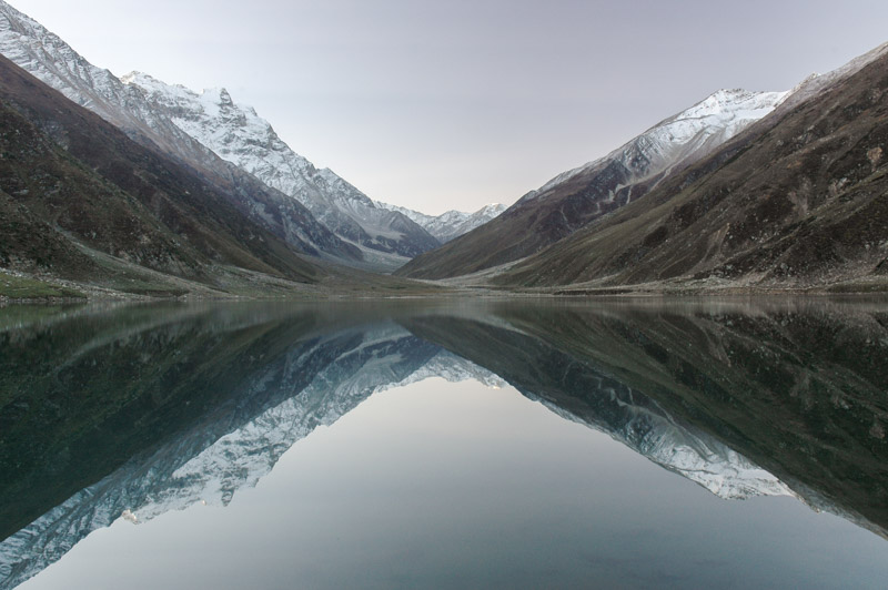
Lake Saif-ul Muluk, North West Frontier Province, Pakistan
Above Naran the valley begins to opens up, but becomes more sparsely populated. In the village of Burawai however, our progress ends. A speeding lorry has destroyed the bridge, which is still sticking out of the water alongside a half submerged bulldozer which has failed to cross the river. The Army have been deployed (for this is a sensitive region close to the disputed Indian border), but it is clear that it will be a long time before anything is fixed.
Locals suggest that an alternative, small wooden bridge a few kilometres down the road would be suitable for my car, and which after passing through a small village, would rejoin the main highway just beyond the collapsed bridge. Not wishing to undertake a backtracking detour of almost 400 km, I opt to take the bridge, which very nearly ends in disaster. The bridge is constructed from nothing more than tree trunks, which are not in any way held together. As I tentatively make my way onto the bridge, the rear wheels spin, bunching up the logs until the wheels dangle freely above the two main supports and the thrashing water just below. Trying to extricate the car using four-wheel-drive makes the situation worse, and ends with the front right-hand wheel dangling on the edge of the bridge. The river is not far below, but is full of large boulders and running extremely quickly.

Hinko Man, Naran, North West Frontier Province, Pakistan
I start to unpack the car to reduce its weight, and locals, held up by my stranded car, come to assist. Over the next hour or two, with their eager help, I jack the truck up in each corner and reassemble the bridge under its wheels. The ‘best driver in the valley’ is called to try to move the truck, but after seeing its precarious position refuses to get in. Finally, with a crowd of perhaps twenty, a line is attached to the front of the truck and very carefully, in four-wheel-drive, and staying clear of the brakes, I tractor the car across the log bridge and, elated, make it to the far side. The locals then tell me that the same thing happened last week, and that the rescue operation took the entire day.
The track through the village is tiny, and designed for smaller Jeeps, but I make it through with only a couple of scrapes, come down a steep and rough track which overlooks the bend in the river with the stricken bridge, and I am finally back on the road, shaken, but thrilled. It is by now getting late and cold, and we ask a nearby Army captain about finding a place to stay. Ali is a mild-mannered and well-spoken Sindhi from Karachi, a refreshing oddity in an organisation which is almost exclusively Punjabi. He immediately offers us a place in the captain’s mess in the nearby town of Battakundi. Andy and I leave our vehicles with some of his officers who will be staying in tents at the roadside, and set about crossing the river again. This involves clambering over the rubble and wreckage which is lying in the river, and climbing onto the stranded bulldozer. One of Ali’s officers on the far side of the river then drives an enormous earth-mover half into the river as far as he dares, and we jump into its enormous steel bucket. He then lifts the bucket and deposits us carefully on the far side of the river like a lioness setting down her cubs by the scruffs of their necks.
The captain’s mess is extremely comfortable, and we are waited on by his officers like esteemed visitors. Ali appreciates the beauty of his surroundings, but misses his native Sindh (as do I). The local Kohistanis who live above Burawai and beyond the the pass at the head of the valley are hostile to outsiders, and their children are renowned for stone throwing which Ali warns us about. Having a crew of officer’s at his disposal, Ali is able to have the children rounded up and given a good thrashing as a deterrent to stoning the Army.

Babusar Pass (4100 m), North West Frontier Province, Pakistan
After an unexpected night of comfort and good company, we cross the river one final time in the morning, and wishing Ali well with his work here, continue our journey north. As we make our way up the valley, the scenery becomes starker, passing the glacial water of Lulusar Lake and finally reaching the 4100 m Babusar Pass, with monochrome views over a huge, uninhabited upland area strewn with glacial moraines. The pass marks the border of Pakistan’s Northern Areas, a region not formally incorporated into the state of Pakistan, claimed by India but administered by Pakistan since 1947. We descend on the north side of the pass, attracting the inevitable hail of stones from the native Kohistani boys (I remind myself to bring a slingshot on the next trip), to the town of Chilas which lies in an impressively barren bend in the Indus river valley, on the famous Karakoram Highway.
The Karakoram Highway, or KKH was completed in 1979 and was an audacious engineering mega-project to cross the India subcontinent – Eurasia collision zone and link China and Pakistan by means of the 4700 m Khunjerab Pass, opening-up some extremely isolated mountain valleys which had previously only been seen by explorers and mountaineers. It follows the Indus River north to Nanga Parbat, then the Hunza River still further north through the Karakoram, passing the Tajik-speaking valleys of Gojal all the way up to the Chinese border where it skirts the Pamirs down to the historic Silk-Road oasis of Kashgar. Owing to the restrictions and expense of driving one’s own vehicle into China, my north-bound journey will end at the border.

Pakistan – China Border, Khunjerab Pass (4700 m), Northern Areas, Pakistan
Passing the 8,126 m high mass of Nanga Parbat, the ninth highest mountain in the world, we (Andy and I; Nao has gone ahead to the Hunza Valley) reach the friendly Shina town of Gilgit, located just off the KKH. At the police checkpost on the edge of town, I befriend two Belarussian telecoms engineers who invite me for Belarussian vodka in the town’s best hotel, where I am joined by Englishman Karl, a part-time chef and perennial long-term traveller. We drink vodka out of clear water glasses, and talk of Belarus and the former USSR – a rather culturally disorienting conversation in this remote and conservative mountain town.
I meet Nao again in Karimabad further up the KKH, and we travel for a few days together via Passu to Sost, the last town in Pakistan. Here she leaves on a minibus to China where I cannot follow; it is the last time we see each other.
Although I have crossed the pass five years ago, I decide to drive up to see it once again. The road twists through harsh and rocky terrain, climbing past the yawning Koksil Valley, high, desolate and uninhabited but for a few Marco Polo sheep. Clouds start to roll down as I approach the pass, the wind is fierce and the temperature freezing. After a cup of tea with the friendly border guards who live a pretty grim life up on this windswept pass, I return to Sost and regroup with Andy and Karl.

Wakhi Tajik Woman, Yarzrich, Chapursan Valley, Northern Areas, Pakistan
The magic of northern Pakistan and the KKH is partly the stupendous scenery, but also the diversity of people who live in the myriad isolated valleys which the KKH connects. The following day the three of us venture into the Chapursan Valley, nestled in the very north of Pakistan, which runs into the Wakhan Corridor of Afghanistan. The pastel grey-brown valley consists of scattered villages where yellowing poplar trees mark potato fields and polo grounds, surrounded by high and impenetrable mountains on three sides. The local Wakhi people are extremely welcoming despite the simple conditions of their existence, and invite us in for tea in the village of Yazrich. Strikingly fair-skinned and European-looking, they are believed to have migrated from northern Afghanistan into the region several centuries ago. The houses are similar in style to those of the Pamir region of Tajikistan, with four separate living quarters surrounding a central seating area, and roofed with wooden beams in a distinctive concentric octagonal pattern. Rather than being chronically timid or simply absent, the local women would engage in conversation, however limited by language, a refreshing change after a month of speaking only to men. We finally reach the last village in the valley, Zuud Khun and the charming guesthouse of the ebuillient Alum Jan, a gentle giant of a man who more resembles an Amerindian than a Pakistani. The village is fantastically tranquil and bucolic, and I spend three pleasant autumn days walking here and unwinding.
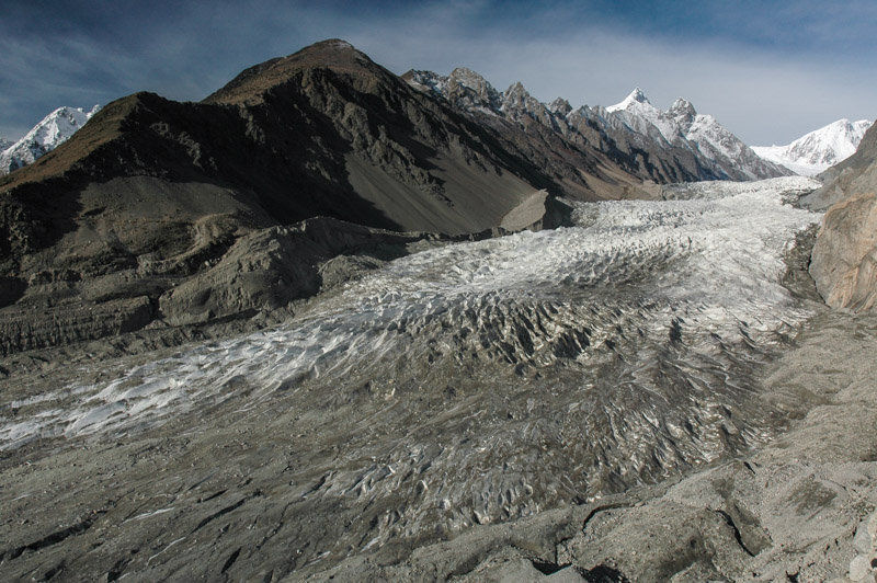
Passu Glacier, Northern Areas, Pakistan
My next stop is the roadside village of Passu, consisting of just a few shops and hotels, located on the east side of a vast 7500 m Karakoram massif, the most impressive stop on my 2003 trans-Asia journey, and possibly my favourite spot on Earth. Walking a little way south of Passu village, one climbs the terminal moraine of the Passu Glacier, walks up its left-lateral moraine, then further up a treacherous scree-slope into the Yunz Valley, which is inhabited seasonally by shepherds who live in rudimentary stone huts with their flocks. From the edge of the Yunz Valley one has an unobstructed vista of the calving white seracs of the cascading Passu Glacier, which winds down in an impressive swathe from the huge, glaciated massif. Climbing still further from the Yunz Valley to a ridge named Golden Top, which sits at 3400 m, one thousand metres almost directly above the village and the KKH, one gets a 360º panorama of some of the world’s most impressive mountain scenery. At one’s feet unfolds over 20 km of the 57 km long Batura Glacier, a vast tongue of ice which is one of the world’s longest non-polar glaciers, and in its lower reaches is a carpet of grey ice and moraine, only revealing a core of clean white ice further up in the centre of the glacier.
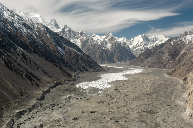
Batura Glacier, Northern Areas, Pakistan
The day is warm and pleasant, and sharp, delicate cirrus clouds spin an ethereal blanket in the turbulent air currents above the massif, mirroring the glacial forms below. The Hunza River flows alongside the KKH far below me, where occasional vehicles pass silently, unknowingly along the terminal moraine of the glacier. Not a soul moves in the valley at my feet, and there is silence but for the occasional groaning of calving ice. On the opposite bank of the Hunza river from the village are barley fields punctuated with yellowing polars, reached by precarious-looking wire bridges which sag just above the frothing glacial water. Beyond this thin strip of agriculture lies an impressive wall of rock; the Cathederal Peaks, a jagged, sharp wall of five to six thousand metres which looks not unlike whipped peaks of meringue. It’s hard to imagine anywhere more beautiful.

Cathedral Peaks, Passu, Northern Areas, Pakistan
Seeing such sublime scenery, under the crisp, cerulean-blue autumn skies is an experience which far transcends words or description. One could spend hours, days, months perhaps just admiring the view, contemplating the scale, beauty, silence and power of such an awesome view. It is an experience which will stay with me my entire life, one with which all others may be put into perspective, one which defines and fulfils the basic urge to travel, and see, and know.
Passu is a paradise for hikers and trekkers, though like everywhere in northern Pakistan, it sees virtually no tourists. Pakistan’s fledgling tourist industry was killed by the events of September 11th 2001, and is dealt further blows with heightened turmoil in the country. This leaves just a small clique of travellers who visit the country, male members of which generally agreeing that it’s their favourite.

Rakaposhi (7788 m), Karimabad, Hunza Valley, Northern Areas, Pakistan
Fifty kilometres down the KKH on the south side of the massif in Hunza proper, lies the charming hillside town of Karimabad. Not quite as spectacular as Passu, Karimabad has a eagle’s eye view of the stupendous Hunza Valley, and is arguably even more picturesque, with its swathes of greenery either side of the Hunza River. To the north, a huge cleft in the massif reveals a glimpse of the Ultar icefall; a tumbling glacier which looks like a colossal frozen waterfall. Sitting at the base of this defile is the impressive Baltit Fort, where the Mirs of Hunza lived until 1945, and whose architecture has elements of the Moghuls and Tibet. Rakaposhi, at 7788 m sits to the south-east and completes the magnificent surroundings of the town. As in Passu the autumn light is magnificent; the world seems to be caught in freeze-frame between the frenzy of summer and the bleakness of winter, a sea of riotous colour etched in gorgeous cool light.

Shyok River, Khapalu, Northern Areas, Pakistan
Sadly the town itself is not in such a splendid state; a hotel boom which was killed by the events of September 11th 2001 has left dozens of half-finished buildings, bristling steel reinforcement rods and dangerous, sagging wiring. The steep main street is a muddy mess of concrete rubble and broken asphalt up which labouring minibuses and Jeeps grind in clouds of smoke. The local Burusho people – who speak an intriguing language isolate unrelated to any known language – are extremely pleasant and tolerant, but the practice of marrying first cousins in such a small community has a clear effect on the demographic; at times it seems like half the population on the streets are lunatics, shouting at the sky, walking with a sleepwalker’s trudge,, wheedling for food at the village’s eating stalls. Nevertheless, the squalor does little to detract from the overall setting.
In Gilgit once again, Andy, Karl and I regroup and head off east, passing the northern flanks of Nanga Parbat on the KKH, then joining the Indus once more and driving upstream into Baltistan, the Indian-controlled side of which I had driven through with Nao two months earlier. The road teeters high above the river, winding through tight mountain valleys until reaching a large, open area along the riverside close to the town of Skardu. Beyond the town the valley is wide and filled with alluvium, and the Indus a deep turquoise, looking very much as it did in Ladakh. Beyond the pleasant Balti town of Khapalu, we reach the furthest point on the road towards the disputed Indian border that foreigners are permitted to travel on, and then head north into the Hushe Valley.

Machulu, Hushe Valley, Northern Areas, Pakistan
Deep in Baltistan, the Hushe Valley is one of two approaches into the highest reaches of the Karakoram, where K2, the world’s second highest peak sits at the head of the Concordia Glacier in an area known as the ‘Throne-room of the Gods’. Sadly it is too late in the season to go trekking, but the valley is still open and accessible. The rough road up the valley passes in its lower reaches through neat and even elegant settlements such as Machulu, which consists of a central mosque surrounded by squat one and two-storey whitewashed houses of strikingly Tibetan form, amidst yellowing poplar and apricot trees.
When we arrive at the head of the valley however, in the village of Hushe, the impression is very much less elegant. Hushe is the most hopeless and squalid place I’ve seen for a long time, a muddy slum of collapsing stone hovels, like a medieval European forest camp. The people are filthy and stand slightly menacingly, staring at us coming into the village. A pack of the most wretched-looking feral children appear, with grubby brown snot-smeared faces, a multitude of skin conditions, all adorned in filthy rags, their genetically anonymous faces suggesting a particular dedication to inbreeding. Andy, who arrives before Karl and myself maintains that he saw a man getting out of bed with a sheep’s head; there are children with bloated heads, three ears and growths around their mouths. We take a grubby room in the village’s only guesthouse, but opt to cook our own food after seeing the ‘kitchen’; a filthy, greasy black hole. With Karl along (a professional chef), and the full kitchen dragged out of the back of the truck, this is by no means a hardship.

Shigar Valley, Northern Areas, Pakistan
Despite the squalor of the village, the surroundings are magnificent; 7821 m Masherbrum sits at the head of the valley, and the nearby Humbrok Valley is just beginning to freeze over for the winter. The snow however restricts our options for trekking, meaning we leave the Hushe without even a view of K2. On the way back to Skardu, we pass the magnificent and yawning entrance to the Shigar Valley, where the Indus River becomes wonderfully braided, flowing across a plain of fine alluvium which the wind has whipped in places into towering sand dunes, somewhat incongruous in this rarefied mountain setting.
From Skardu Andy and I say farewell to Karl (I will meet him again in the UK in 2012), and drive south, climbing onto the Deosai Plains, a huge Himalayan wilderness of rolling grassland at 4000 m, which stretch west as far as the Babusar Pass and Kaghan Valley, and east as far as the disputed Indian border close to the town of Drass. The views are immense, of endless yellowing grass, framed by distant peaks in troubled Kashmir. Streams criss-cross the plains, requiring river crossings and at one point driving over a rickety suspension bridge, before descending north-west towards Nanga Parbat, the westernmost outlier of the Himalaya.

Nanga Parbat (8126 m), Northern Areas, Pakistan
Andy and I reach the village of Tarashing late one evening, and the following morning I trek up through Shina and Kohistani villages to the moraine of the Tarashing Glacier, beyond which, just a few hundred metres away is the Rupal Face of Nanga Parbat; a four thousand metre vertical wall of rock which is almost incalculably vast-looking at this proximity. Nanga Parbat is the western anchor of the Himalaya; to the north of the Indus lies the Karakoram Range, while to the west, beyond the Indus and Hunza Rivers, lies the Hindukush.
The mountain marks the end of a six-month traverse of the Himalayas, starting back in Sikkim at Kanchenjunga in May, and moving gradually west through Nepal, Ladakh and Kashir. Had I found the same magic this time as that which so impressed me in 2003? Well, surprisingly yes. But I never found anything to beat that spot high above the village of Passu. Now winter is fast approaching, and thoughts begin to return to the warmth of the lowlands.
