
Stage 44 – Russia: The Siberian Winter [2/3]

With the deep cold of the Kolyma Highway and the remoteness of the Lena River Ice Road behind me, I felt I had completed what were likely to be the toughest and most dangerous parts of my winter journey. Buoyed by the success of driving as far up the Lena as possible and with no hint of any issue with the Hilux Surf, I was confident of making the next section of the journey. This would take me onto the Tas-Yuryakh to Verkhnemarkovo zimnik (seasonal winter road), then across the ice of Lake Baikal, onto the regular road network to the city of Tomsk, and on to the end of the road on the Ob River. However, I still had to find a way through a private road to reach the zimnik and had no idea of the ice conditions or feasibility of driving on Lake Baikal. Once again, I was heading out into the unknown.

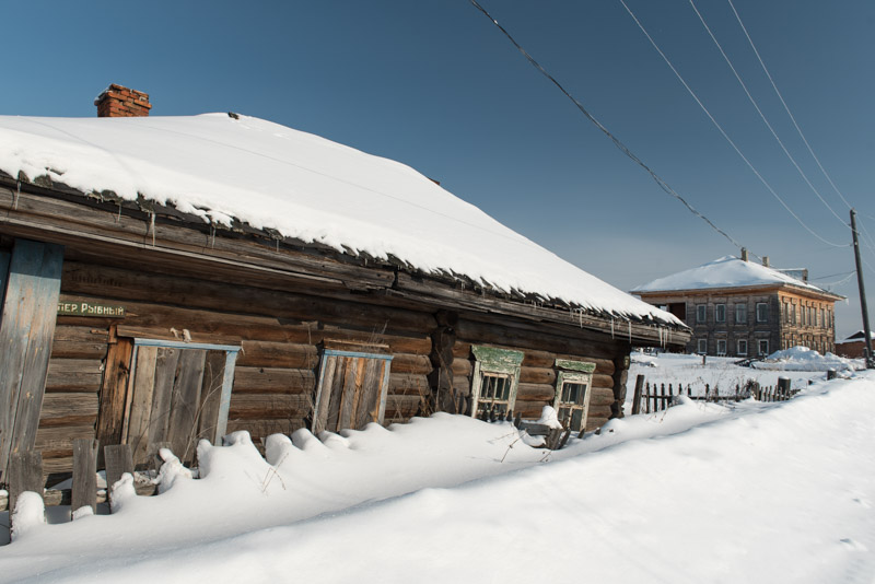
Lena River Dock, Vitim, Sakha Republic, Russia
On the morning of the 13th February 2018 I wish Lyuba and Gleb, my hosts in Peleduy, farewell, thanking them for their warm hospitality in this friendly town in the heart of the Siberian wilderness, and drive to the neighbouring town of Vitim to fill up with fuel. Vitim is as far up the Lena River as one may travel by road from Yakutsk; from here it will be around eight hundred kilometres through the vast taiga of eastern Siberia before I reconnect with the river near the city of Ust-Kut. I pass the dormant, ice-bound river docks on my way out of town, then a large blue highway sign with the memorable information ‘Moscow 5796 km’; by far the largest distance I have ever seen recorded on a such a sign. Beyond the turn for Peleduy I am on a private road owned by Surgutneftegaz, a Russian oil company which operates the nearby Talakan Fields, to which the road leads. I am using the road in some trepidation as I should have secured a permit, though on the advice of Lyuba I am trying my luck without one. To be sent back to Peleduy to apply for a permit would be a minor inconvenience. To be refused outright and have to return to the highway in Lensk, via the most brutal section of the Lena River Ice Road, would be deeply frustrating and disappointing.

Lower Tunguska River, Nepa, Irkutsk Region, Russia
It’s almost seventy kilometres before I reach the first checkpoint on the road where I stop and hope not to have to backtrack at all. I am asked for a permit by a guard, but on inquiring how I should obtain one, am told to wait while he takes my passport and summons his boss. After an hour or so I fill in some brief paperwork, then am told to follow two gentlemen in a company pick-up truck, who escort me through the huge Talakan Oil Base, effectively a private town complete with airport, surrounded by dozens of well pads and oil-extraction infrastructure. We pass a second checkpoint, then stop at a third where my documents are checked, my escort bids me farewell and I pass through a barrier at which a long queue of lorries waits, with a sense of huge relief. This marks the end of all the uncertainty along the Lena River; from here I am certain that it is possible to reach Ust-Kut and the formal Russian road network. This last section of the private road runs northwards to the Verkhnechonsk Oil Field and soon after leaving the third checkpoint a sign announces the border between the Sakha Republic and Irkutsk Region. It has taken me two weeks to cross the republic, which is not only the largest in Russia but the world’s largest sub-national territorial entity. My mind boggles at the vast northern reaches of the republic which stretch well above the Arctic Circle. About an hour after passing the border sign, I encounter a crossroads in the utter middle of nowhere and turn left onto the infamous Tas-Yuryakh to Verkhnemarkovo Zimnik.
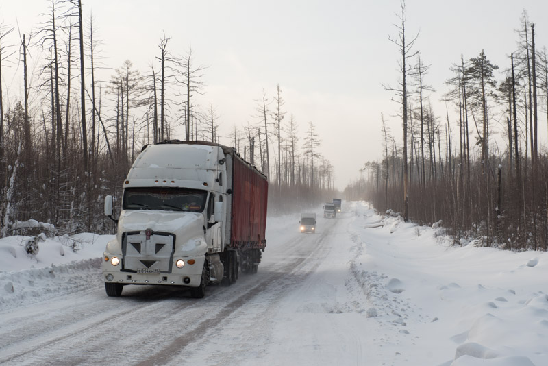
Tas-Yuryakh to Verkhnemarkovo Winter Road, Irkutsk Region, Russia
The zimnik is winter-only road consisting of solid-frozen swamp which runs for 850 kilometres through the thick taiga of eastern Siberia, passing only one village and no fuel stations on its route to the roadhead at Verkhnemarkovo. I join the zimnik 470 kilometres out from Verkhnemarkovo and see immediately that it is a very different proposition from the Lena River Ice Road. I am surprised by just how much traffic there is, much of it large, articulated lorries carrying supplies up to the oil fields and mines of the Siberian north, servicing the industries which fuel the Russian economy. With the traffic comes a reassurance that this seasonal road is in passable condition and that I will not get stranded for days on a lonely frozen river. But the heavy lorries compress deep ruts into the frozen swamp with a wheel-track far wider than mine, causing the car to tram-line dangerously and sometimes spin. Extreme caution is required when passing oncoming lorries, who take the best line and may pass me on the right rather than left according to conditions. Especially dangerous is overtaking, as any spin would most likely cause a collision. I see several accidents along the route, though the low speeds mean that none look particularly serious. It is nevertheless a good feeling to be on this busy winter road, despite it being a far from relaxing drive. As the day wears on, the sunshine smooths the very top of the road surface of compacted snow, making it extremely slippery with my stud-less winter tyres. I spin frequently and so keep my speed very low, eventually finding an area to pull in for the night overlooking the Lower Tunguska River with the village of Nepa, the only permanent settlement on the zimnik, on the far bank. I heat up more Russian Army rations on my butane stove then settle down for a night with the heater running and engine off.
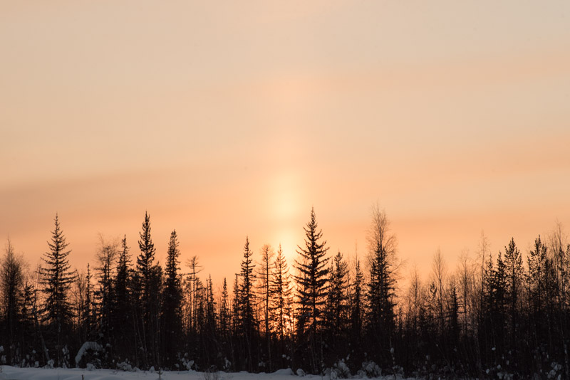
Sunset, near Verkhnemarkovo, Irkutsk Region, Russia
In the morning the temperature has dropped to -29º C from last night’s -18º C but the car’s engine fires to life from dead cold immediately and with no alarming noises, further boosting my confidence in the Hilux Surf as a remarkably dependable vehicle. I drive for the entire day on the zimnik, mostly passing through dense taiga but sometimes patches of frozen, leafless birch forest whose trees lean over into the cleared roadway. In other places the forest is bare and open, a victim of summer wild-fires in recent years, or marked by grids of narrow, cleared corridors for past geophysical surveys. As I progress further southwards, the road occasionally twists and turns for reasons which aren’t obvious to me on the ground and there are temporary wooden shacks serving food to passing lorry drivers. In a cleared area adjoining one such establishment I stop to pour forty litres of petrol into the car and get chatting to one lorry driver, who tells me I am the first tourist he has ever seen on the zimnik. I ask him how long the road is open, out of curiosity. “Only in the winter. If you bring your truck up here in March, or early April when things start to melt, you can get stuck. Then you can forget about your truck”. As the day wears on the road gradually improves and passes the flare stacks of the Yaraktinskoye Oil Field. I take in a spectacular, slow sunset which seems to be amplified by a lensing effect of winter ice clouds, pass the turning to Verkhnemarkovo and for the first time since Ulakhan-An, near Yakutsk, join the Russian public road network.

Baikal-Amur Mainline Monument, near Kunerma, Irkutsk Region, Russia
It’s -30º C the next morning and after another effortless cold-start I soon meet the Lena River which here is merely an average-looking river rather than the vast waterway I had earlier encountered. Ust-Kut is busy with morning traffic and feels very ordinary after all the wilderness I have been driving through since Yakutsk, but here I find a bridge across the Lena; the furthest downstream on the river, despite being around 3500 kilometres from its mouth on the Laptev Sea. On the far side of the bridge, I catch my last glimpse of the river; this mighty Siberian giant along which Russian explorers and traders conquered the easternmost reaches of the country, and along which unfolded a personally unforgettable road journey. A junction takes me onto the ‘Avto BAM‘, an access road for the purpose-built settlements of the BAM, or Baikal-Amur Mainline, a communist white elephant project which runs all the way to the Pacific Ocean and which has never quite sparked the local development which was originally intended as its purpose.

Ice Fisherman, Severobaikalsk, Buryatia Republic, Russia
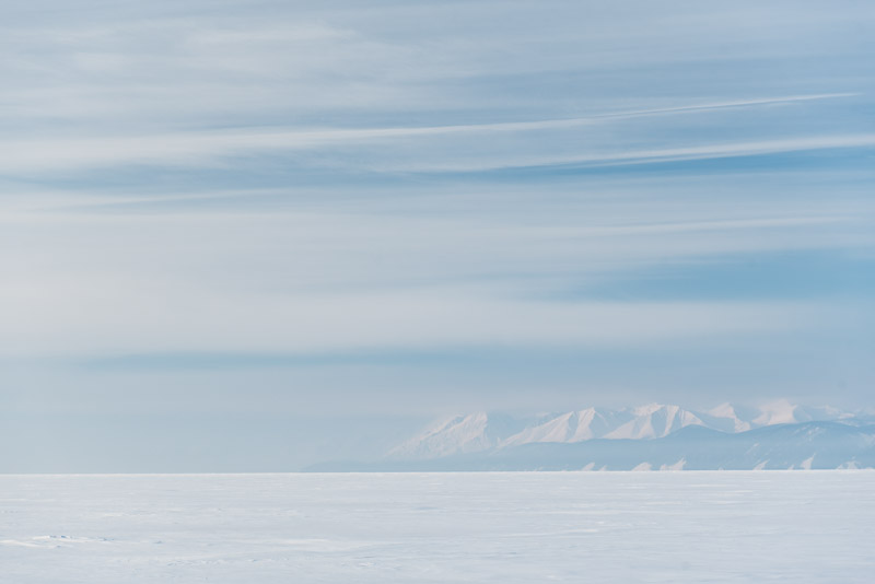
The road winds through a series of hills and valleys, a nice change from the dense taiga, and is well graded and cleared. Traffic is light and the weather crisp and clear, making it a pleasure to drive. The BAM passes through a number of settlements built in the 1970s and 80s though today they are clearly smaller than intended, sometimes heavily depopulated. Many of the buildings are however smart, distinctive and well constructed with touches of the national designs of the BAM construction teams from different parts of the Soviet Union who built them; Zvezdny has a striking station building finished in the pink tuff characteristic of Armenia, and nearby Nebel has pastel-coloured clapboard building which look to be Baltic in style. The overall impression however is of a number of ill-conceived settlements where few people find a reason to remain. Beyond Kunerma the road narrows and dramatic, steep peaks of the Baikal Range rear up, the first real mountains I have seen since leaving the Verkhoyansk Range on the Kolyma Highway. I cross the Davan Pass surrounded by snow-covered peaks and descend on a jarringly rough road, stopping at a lookout point above the city of Severobaikalsk. Out beyond the rooftops is the huge, white expanse of Lake Baikal, frozen solid and tinted soft pink in the evening light, which also picks out the gorgeous contours of the mountains on the lake’s eastern shore.
Lake Baikal, Severobaikalsk, Buryatia Republic, Russia
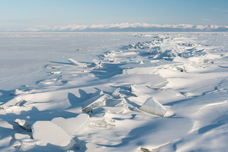
Lake Baikal is a magnificent sight, and I walk out onto it the next day, thrilled by the blinding white expanse of ice on which locals walk, cross-country ski and fish through small holes. My intention is to drive across the ice to the town of Ust-Barguzin on the lake’s eastern shore, and possibly on to Olkhon Island from there. Once again, the feasibility of this plan is uncertain; my host Aleksey thinks it’s still a little early in the season, with the ice optimally thick and static in mid-March, still a few weeks off. The ice fishermen I speak to, many of whom have cars parked out on the ice, tell me it is technically possible, however none of them have done it this year. The only marked track on the ice runs directly across the lake to the Khakusy Hot Springs on the eastern shore. I begin to worry that my ambitious plans may be unrealistic. Aside from this, it is also technically illegal to drive on the ice, though like the local fishermen, I intend to ignore this inconvenient regulation.
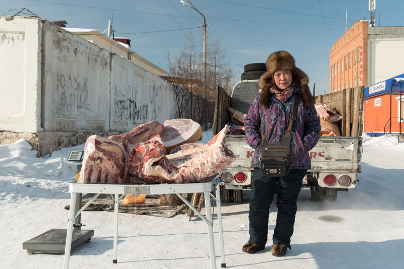
Buryat Meat Seller, Severobaikalsk, Buryatia Republic, Russia
Away from the beauty of the lake and its jagged mountainous backdrop, Severobaikalsk is a very pleasant town; much of it pre-fabricated 1980s concrete of little aesthetic appeal, but it is neither overcrowded nor underpopulated, and very friendly. All the time however, I feel myself being drawn back across the footbridge of the busy BAM station to the embankment of the lake, from where the views are stirringly invigorating. On my second morning in Severobaikalsk, I take another walk around town wondering if I should risk venturing out onto this ice alone, if necessary following a bearing on my GPS receiver, though I have no local knowledge of where the ice is likely to be drivable. I meet a Buryat lady selling large chunks of meat on a table in the open air, the Siberian winter providing a natural deep-freeze better than that in any supermarket. Customers order by weight and the meat is carved with a chainsaw. I happen to mention my plans to her and am very excited to hear that she and her husband, who is keeping warm in the cab of their pickup truck, drove up from Ust-Barguzin yesterday on tracks across the lake. They tell me that there is snow on the ice, but not too much to drive through. Relieved to hear this, I conclude my time in Severobaikalsk with a visit to the BAM Museum and lunch in a typically Soviet stolovaya (canteen). Later in the afternoon I say goodbye to Aleksey and drive in the dark down to the village of Baikalskoye, around forty kilometres to the south, where the road ends and the tracks should set off across the lake.

Baikalskoye, Buryatia Republic, Russia
I awake to a cold morning of thin cloud and a beautiful view of the snow-dusted wooden houses of the village, each streaming a small plume of smoke which sits in the heavy, still air. I drive down to a beach with a small jetty where a number of boats have been scuppered for the winter. Beyond, a huge, barren expanse of ice extends to the southern horizon. After making use of a latrine with one of the finest views I can remember, I drive out onto the ice. I’ve seen two other cars drive out onto the ice this morning but was not in a position to stop the drivers to ask directions. There are numerous vehicle tracks on the ice, but I suspect the great majority have been made by local fisherman or hunters driving to their favourite nearby spots. One track heads arrow-straight out onto the lake, so I chose this track. I once again have the slightly nervous feeling of heading into the unknown. This is an illegal, unofficial track. If something happens out on the lake, I will most likely be totally alone.

Tracks Across Lake Baikal, Buryatia Republic, Russia
Driving is initially excellent as I get used to being on the surface of a huge, deep lake, getting increasingly far from land. Several vehicles have recently used these tracks and whilst the snow is thick enough to obscure the ice at all times, it is currently thin enough not to worry about getting stuck. The ice surface feels smooth in places, though it is clear that the ice is not static, forming pressure ridges and occasional cracks a few centimetres wide, though the open water rapidly re-freezes. I am initially only concerned that the track appears to be heading towards the lake’s eastern shore, though after around thirty kilometres it turns southwards towards Ust-Barguzin. I suppose it’s human nature that the individuals who first made these tracks wished to be reasonably close to the reassuring mountains which rise up straight from the shoreline. A little further along, I start to worry when I notice the tracks diverging and thinning, and the snow getting thicker. Mounds and ridges of broken ice dot the surface causing the tracks to twist chaotically around these obstacles and I eventually find myself following a single set of tracks through increasingly deep snow. I recall travelling in remote parts of Mongolia, following little-used tracks which would suddenly thin out, usually signalling an obstacle or bad patch of road lay ahead. Sure enough, I come across a large crack perhaps sixty centimetres wide. Brashly, I drive across the re-frozen water and make it to the far side without a problem. I then make a very foolish decision to reverse back over it, in order to take a photograph of the car crossing the crack. Reversing more slowly across, I feel the wheels punch through the ice, but clamber out to the far side. I am then left in the alarming situation of having the car straddling the crack which is now partially open, with nothing but eight hundred metres of cold water below me as I open my door and look down in anguish. I consider my options, then brashly gun the accelerator with the transfer box in low-range to maximise the torque to the wheels. I make it across without an issue but am left rather shaken; along with my crash into a snow-bank on the first day out of Magadan, this is my closest brush with disaster. The crack is far too narrow to swallow the car, but an axle stuck in the crack and resting on the chassis would make for a very difficult recovery.
Baikal Mountains, Buryatia Republic, Russia
Amazingly, just as I am preparing to leave, a local car approaches; an overloaded Toyota Corolla estate car with the panels of a garden shed stacked on its roof. I stop the driver to warn him of the wide crack. In typical Russian style he picks a spot where the crack is somewhat narrower and nonchalantly guns the low-slung car across. Now on the far side of the crack, I am doubly relieved to see that the track is again more heavily used, and continue calmly southwards. I start to spot people with cars closer to the shore, fishing from small wooden sheds. It’s still more than one hundred kilometres to Ust-Barguzin, so I imagine that the fishing is particularly good – or illegal – here. As the day wears on, the weather worsens and visibility becomes poor, at times a white-out when I am simply driving into a white void, with lake and sky merging into one white mass. Thankfully, there are occasional markers stuck in the ice, delineating the boundary of a nature reserve into which entry is strictly forbidden. Early in the afternoon I reach the entrance to Chivyrkuysky Bay and although an ice road of sorts has been cleared recently, the ice has a nasty, wet sheen to it, and I feel more drag from the wheels, as if the ice were becoming slushy. I decide to put my foot down rather like gunning a tender against the tide into a difficult landing. Eventually, 223 kilometres after leaving Baikalskoye, I make landfall as I drive onto the ice-covered beach in the tiny village of Kurbulik, with a sense of achievement and relief, having completed another uncertain and potentially dangerous section of the trip.

Lake Baikal, Slyudyanka, Irkutsk Region, Russia
I’ve actually landed on the Svyaty Nos Peninsula and it’s a bumpy fifty kilometre drive on a washboard track – something I have come to expect in Buryatia – to the town of Ust-Barguzin, a place I have very fond memories of as it was here that I met Finns Toni and Marjo back in 2010, the start of six weeks of travelling together through stunning autumnal landscapes of Siberia and Mongolia. Afternoon clouds now hide the gorgeous scenery, but this does little to dampen my spirits after successfully crossing the lake. A bridge now spans the Barguzin River, replacing the old ferry service which I used on my previous visit, and once in town I make my way to the lake shore where we camped for one glorious, warm autumn evening, this time to see if there are any tracks heading across the ice towards Olkhon Island. On reaching the lake shore I see nothing, and a local fisherwoman shrugs her shoulders when I inquire about a track across to Olkhon. The ice looks sweaty and unsound to me so I decide to abandon the idea, having already pushed my luck enough. It’s a joy to drive into the darkness on the newly paved road to the junction town of Irkilik where I spend the night, pushing on in the morning. I decide to avoid a long highway detour through the regional capital Ulan Ude and instead drive on a small road on the right bank of the Selenga River where I soon find an ice road across the river. On the river’s left bank I reach the small town of Tataurovo and join the Trans-Siberian Highway for the first time on this trip. Here I’m suddenly reacquainted with poor driving and dirty brown road slush; two things I have not missed while driving on the icy tracks of the north. In the industrial lakeside city of Slyudyanka I climb into the very eastern edges of the Sayan Mountains, catch my last glimpse of this beautiful lake and by mid-afternoon reach my next stop; the city of Irkutsk.

Lenin Street, Irkutsk, Irkutsk Region, Russia
Irkutsk lies astride the Angara River just downstream of where it emerges from Lake Baikal. Like many Siberian cities, its origin lies in a fortress from which early Russian pioneers extracted yasak (tribute) from indigenous Siberian tribes and began to exploit local gold deposits. When the popular Decembrist Revolt against Tsar Nicholas I took place in Saint Petersburg in 1825, Irkutsk soon received a number of Decembrists; nobles and officers, often accompanied voluntarily by their wives, whom the Tsar banished to distant Siberian outposts. With the influx of such exiles, Irkutsk saw a great intellectual, educational and cultural flourishing which later with the advent of the Trans-Siberian Railway in the last years of the nineteenth century, saw the city gain an epithet as the ‘Paris of Siberia’. My pretty Buryat host Julia takes me out in Irkutsk to see a number of surviving wooden buildings from this era, often beautifully adorned with nalichniki (decorative window frames). These buildings are either run-down tenements or meticulously preserved museums, in both cases sticking out rather incongruously from the city’s often haphazard streets of Soviet concrete and modern blandness.

Angara River, Irkutsk, Irkutsk Region, Russia
The twentieth century favoured Irkutsk rather less; brutal fighting during the Russian Civil War was followed by heavy industrialisation in Soviet times, though the city has remained a centre for education with Irkutsk State University an integral part of the city’s elegant Stalinist centre. Striking out on my own for a full day’s exploration, I see a variety of sides of the city; the colourful Baroque of the Epiphany Cathedral above the steaming water of the Angara; the slightly gritty embankment where men fish from desolate banks; the wooden houses slowly being edged out by ugly, modern construction and the grimly industrial suburbs around the large dam and hydro-electric power station which I walk across in the waning afternoon light, looking across the frozen Angara Reservoir feeling a little uneasy at how close this industrial squalor is to Baikal’s drinkably pure water. Though not what I would term a beautiful city, I like Irkutsk’s raffishness and am glad to spend a couple of days here after rushing through last summer. But with the temperature a mere -12º C and the roads filthy with slush, I yearn to return to the clean, cold wilderness to the north.
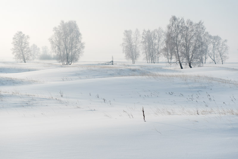
Birch Trees, near Kansk, Krasnoyarsk Territory, Russia
In order to return to the invigorating north, I judge it necessary to move west now for around seventeen hundred kilometres on a route using conventional roads, much of it on the Trans-Siberian Highway, back-tracking my outward journey last year. My route so far has generally followed major rivers, the reverse of the old pioneer trail into Siberia. Ideally, I would now follow the Angara to the Yenisei and make a portage of sorts by zimnik to the Ob, but to my knowledge there is no such road of any sort. Therefore, after leaving Irkutsk I make a solid two-day drive on the modern road, sleeping for the first night among parked lorries in a road-side village, then pushing on, crossing the steaming, strangely ice-free Yenisei on a bypass road north of Krasnoyarsk. From here I am retracing a route I last drove in 2007, on my first visit to Russia and Siberia which made such a deep and lasting impression upon me. Reaching the city of Marinsk as darkness falls, I turn off the Trans-Siberian Highway and join a rather rough road as the weather deteriorates, with heavy snowfall making the last section of the journey to Tomsk rather arduous.

Wooden Houses, Tomsk, Tomsk Region, Russia
Tomsk is one of Siberia’s oldest cities and until the nineteenth century was one of its most important. Two key points in the city’s history have however made it quite distinctive; the decision of its administration to make it a centre of education (many Russian expatriates whom I work with in Europe have studied here), and the fact that the city was bypassed by the Trans-Siberian Railway. This is my first visit to Tomsk and as I start to explore the city I notice that these two factors play off against each other nicely; its (albeit fairly minor) dislocation from the region’s main transport conduit means that modernisation has been rather less brash than in, for example, Irkutsk, yet the city’s youthful, intellectual population means the city feels modern and progressive rather than a somnolent backwater. Tomsk is built along the right bank of the Tom River, a major tributary of the Ob, and sits on the edge of the vast lowland of West Siberia which stretches up to the Urals and the Arctic Ocean. It’s a cold, clear day and the view across the snow-covered Tom towards to a ruler-flat landscape of marshes and patchy birch forest give the city a slight edge-of-the-world feel. In contrast to the riverbank views, the main Lenin Avenue, though not devoid of Soviet concrete, is still a modestly proportioned thoroughfare, much of which is lined by quaint, two-storey, pastel-coloured Tsarist-era buildings and even the occasional wooden structure. I visit the Regional Museum and then cross the road to a former police jail, which is now the Memorial Museum of the History of Political Repression, though the real highlight is simply to walk along a major thoroughfare in a Russian city which has ridden the wild transition to a market economy so beautifully unscathed.

Tatar Sloboda, Tomsk, Tomsk Region, Russia
On my second full day in the city, I start by walking through quieter streets a little east of the centre and find many beautiful wooden houses which, whilst often rather shabby or hemmed-in by modern, red-brick mansions and apartments, are still present in sufficient numbers to constitute perhaps Russia’s best-preserved, living urban landscape of wooden architecture. Some wooden structures are lavishly built with ornate turrets and spires, having once belonged to wealthy merchant families. I however find my highlight of the city close to the riverbank, behind Lenin Avenue in the slightly down-at-heel Tatar Sloboda, an ancient settlement said to date from the seventeenth century, having been founded by ‘Tatar’ traders from Kazan, Tobolsk and Central Asia. Here I stroll along the aptly the named Tatar Street where an almost unbroken line of lived-in wooden houses is overlooked by the tall, green-tipped spire of the early twentieth century Red Mosque; a particularly fine view. In the afternoon my rather excitable host Natasha, a photographer, persuades me to engage in – of all unlikely things one might do during a winter expedition – a spot of menswear modelling for her friend (also Natasha). Resuming my wandering of Tomsk’s backstreets, I amble up Oktyabrsky Vzvoz (ascent) and as the sun lowers behind yet more period architecture and watch locals skating on a large pond in a scene which could be a classical Russian painting.
Siberian Home, Prokop, Tomsk Region, Russia
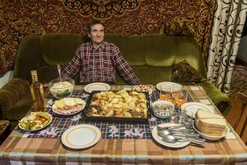
I leave Tomsk on a bright, cold morning feeling I have found Siberia’s most attractive city and one of the nicest in Russia. I cross the Tom which I last crossed with Maciej on a pontoon bridge far upstream in the foothills of the Abakan Range, then shortly after meet the Ob River for the first time on this trip; the westernmost of the three great Siberian rivers. I spend the day driving roughly along the Ob on an excellent asphalt road into what feels like an ever-widening landscape, to the tiny Siberian village of Prokop. Here I have arranged to stay with Slava, who lives with his family in a traditional Russian village house with a kitchen garden, banya and outhouse. I am the first foreigner that the family has hosted and am treated to famously generous Siberian hospitality; a table is soon laid with baked meat and potatoes, sausage, potato salad, pickled wild mushrooms, pickled vegetables, fresh bread and a bottle of rather fierce peppered vodka. The family have also invited a former neighbour, Alex, a Volga German and English teacher from the small nearby town of Parabel to relieve us from having to rely for communication on my Tarzan-Russian. What unfolds is a really lovely evening; the type of inter-cultural communication which makes travel so enjoyable. I go to bed in a warm Siberian home a full stomach and in high spirits, though with the clear, star-filled sky keeping the temperature at a brisk -25º C, the inevitable nocturnal trip through the garden to the outhouse is more than a little bracing.
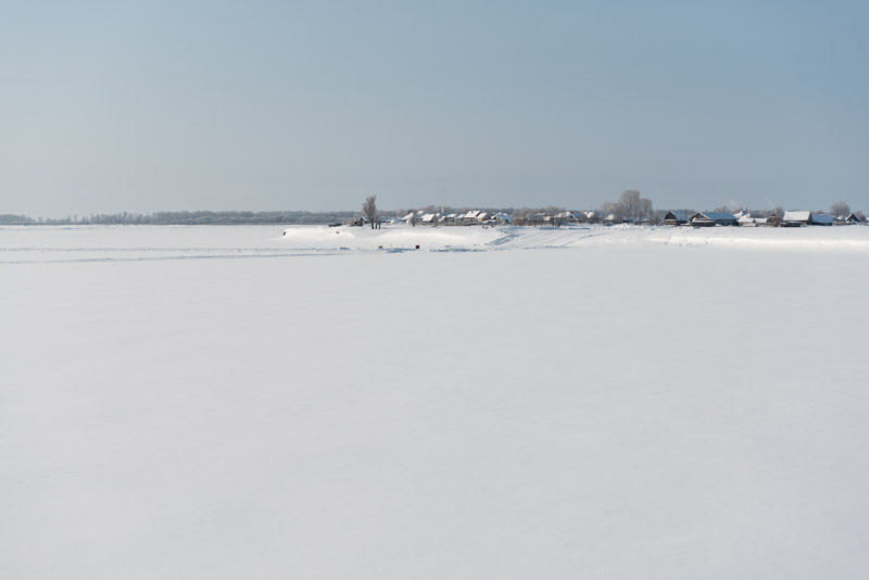
Ob River, Shpalozavod, Tomsk Region, Russia
Though the heart-warming kindness of Slava’s family and experience of Siberian village life would be reasons enough to come out to this distant village, it is the nearby village of Narym which has brought me here. Slava and I drive out on a sunny morning, passing Parabel and joining a winter road which leads for thirty kilometres across lumpy, frozen swamp to the Ob, which we cross on an ice road to reach the isolated village. Narym is the oldest settlement in Tomsk Region, having been founded in 1596 to extract yasak from the indigenous Selkup by pioneers coming several hundred kilometres down the Ob from Surgut. Once a prosperous, if tiny, trade outpost, Narym’s position on a riverbank surrounded by nothing but swamps and vulnerable to flooding meant it never really grew, and was soon permanently eclipsed by Tomsk. Perhaps unsurprisingly it became a lasting destination for exile, first in Tsarist times, when the relocated included Decembrists and Bolsheviks such as Kuybyshev, Sverdlov and most famously, Stalin. In Soviet times, under Stalin himself, thousands were sent here and either summarily executed (gruesome images in one of Tomsk’s museums show the result of the Ob eroding into a bank filled with the bones of an NKVD mass grave) or sent to labour camps. Locals say that “God created Crimea; the Devil, Narym”.

Stalin Bust, Museum of Political Exile, Narym, Tomsk Region, Russia
Driving through the empty streets of the village, the size and quality of the wooden houses suggests early exiles lived in reasonably comfortable conditions, though many of the structures are slowly disappearing into the swamp. Slava and I stop at the bright yellow Museum of Political Exile which is thankfully open and are taken around the museum by one of the lady curators. The museum was once a shrine to Stalin and there is still a plaster bust of the tyrant, fine oil paintings of a young Joseph and old photos of the huge Stalin statue which used to stand in the village. Following his denunciation, the museum was de-Stalinised into a museum of exiled Bolsheviks (ignoring the irony that the Soviet regime continued to exile dissidents here) which later became the current incarnation of the museum. Out in the museum’s grounds is Stalin’s old lair; a very comfortable cottage more holiday-home than prison, from which he chose to escape after just two months of internment. Though lovingly maintained, the place inspires a sense of increased loathing for the man, in view of the truly horrific conditions to which he deported and condemned many millions of Soviet citizens.
Abandoned Houses, Narym, Tomsk Region, Russia
Nonetheless, I can’t help but like Narym, which is looking its best on a crisp, sunny winter morning, though I can only imagine the hordes of pestilent summer mosquitoes rising from the endless swamps all around. I make a stupid decision to ignore a no-entry sign onto what looks to be a short ice road across a channel to the village of Shpalozavod, which turns out to be deep, soft snow in which I bog the car. Slava borrows a shovel from a local home and a passing local, drunk and driving an old snowmobile with one of its tracks missing, directs us on how to rock and power the car out, turning a worrying stranding into a bit of light-hearted fun. We stop on the way back at Chisty Yar, a natural sulphurous hot-spring where we sit in steaming hot water overlooking the deep-frozen swamps along the Ob, then drive into Parabel where we meet Alex at the local school. Here I sit as a very unusual Anglophone visitor, quizzed by the town’s pupils, many of whom have never before met a foreigner. We finish the evening in Alex’s apartment with his wife and friends who ply me with food and drink, rounding off a truly enjoyable day.
Returning with Slava to his home in Prokop, I can’t help but see the irony that in this remote and maligned swamp, I have one of the nicest experiences of the entire trip. It is with very fond memories of Tomsk Region then that I look to the next, and final stage of my journey through the Siberian Winter; back onto winter roads up along the Ob and on to the Arctic.
