
Stage 20 – Russia & South Ossetia: The North Caucasus [2/2]

This final leg of my 2010 journey through the Caucasus would take me through the republics of North Ossetia-Alania, Ingushetia, Chechnya and Dagestan; places almost unknown to the outside world, and places where most Russian citizens would fear to visit, being synonymous with terrorism, war, lawlessness and corruption. While I would witness first hand these negative aspects of the region, they would be minor frustrations in comparison to the fascinating cultural richness of this seldom-visited corner of Russia.
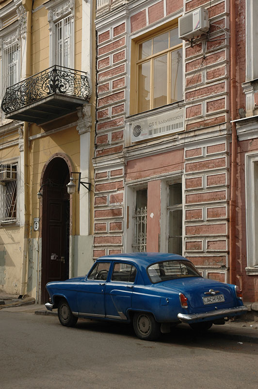
It’s the 19th May 2010 as I emerge from the Roka Tunnel, re-entering Russia and plunging headlong into an ordeal which would recur throughout the republics I am passing through on my way to the Caspian Sea, namely suspicion from the authorities. After winding down ten kilometres past stationary artillery pieces left at the road side, I enter the border compound of Nizhny Zarmag. Instead of passing through with minimal fuss, as I had done four days earlier when I had left Russia, I am the focus of intense suspicion and repeated questioning regarding being a journalist, spy or terrorist. The truck is searched in great detail; a business card in Dari from a Kabul motor factor arouses suspicions, as do my large collection of photos on CDs which are viewed on my laptop. I am made to stay at the border from around 10:00 until closing time at 18:00, when I am instructed to follow a member of the intelligence services all the way down to Vladikavkaz, where I am interviewed by the Federalnaya Sluzhba Bezopasnosti or FSB, the successor of the Soviet KGB. I am asked cleverly sequenced questions designed to expose contradictory or false statements, asked why I am visiting North Ossetia, and upon mentioning some sites in the mountains, I am told that I may not leave any Federal Highway without a special permit. I am ultimately advised that “It is better that you leave our republic”.
The ordeal ends sometime after 22:00 when suspicions are finally allayed, and I am free to go. It is now more than two days since my last meal, the shops are closed, and my intended host Alan has had to leave town at the last minute, all of which make for a less than pleasant introduction. I drive a little way out of town and bed down in the truck in a damp lay-by as rain lashes down outside, thinking that I might just take the advice of the FSB and head east, out of Ossetia. It is curiously reminiscent to my first entry into Russia three years earlier, at the very beginning of the journey.

Vladikavkaz, North Ossetia-Alania Republic, Russia
In the morning, as often happens, circumstances unfold to turn my luck around. I have a stroll in the morning through streets of Tsarist-era architecture, seeing relatively little of the ugly modern development which typifies many provincial Russian cities. Set on a gentle slope astride the rushing grey waters of the Terek River, Vladikavkaz is leafy and green, but shows few signs of being distinclty Ossetian as opposed to Russian. I break my unplanned two-day fast at a small street kiosk next to a bus stop, where I consume a very memorable slice of lemon curd cake, then peruse the bazaar briefly before returning to the car. Here I receive a message from Alan that his trip is cancelled, and I am invited to stay with him and his father Ruslan in their comfortable apartment.
Alan and his father are Ossetians, living descendants of the Alans, a western branch of the Scythians, who as well as being Alan’s namesake, lend their name to the full title of the republic as North Ossetia-Alania. To look at, the Ossetians have Mediterranean features, but are highly integrated into modern Russia. Indeed, the predominantly Orthodox Ossetians have long been Russian allies, something which has helped foment poor relations with their predominantly Muslim neighbours, most notably the Ingush.

School No.1, Beslan, North Ossetia-Alania Republic, Russia
Perhaps the only time that North Ossetia has come to world attention was for the appalling hostage crisis and siege of School No.1 in the town of Beslan, 30 kilometres north of Vladikavkaz, in September 2004. Whilst the motives, number and identity of the attackers, the number of victims, and the exact sequence of events are lost in the murkiness of Russian politics, the incident was unequivocally horrific. Alan drives me first to the new graveyard of all the victims of the school siege, which sits alone out in grassy fields close to the airport. Row upon row of fresh red graves show images of children, often with several coming from the same family.
In Beslan itself, the remains of the school are truly chilling, with boarded-up classrooms strewn with debris; furniture, books and children’s toys are visible through gaps between the boards which partially obscure the smashed windows. In the remains of the central gymnasium, which has been given new roof beams in order to preserve it as a memorial, a cross has been erected and pictures of the more than 300 victims are hung on the walls. The gymnasium bears many scars from the siege; holes in the thick wooden floor, bullet holes, ballistic damage and blackening from the explosives of the hostage-takers and the weapons of the Russian Army who stormed the school despite ongoing negotiations. It seems that many of the hostage-takers were Ingush, rather than Chechen as initially assumed, and that the crisis is one more recent orgy of inter-ethnic hatred in the Caucasus between neighbouring nations. Perhaps because the ruins are so fresh, or perhaps because so many of the victims were children, I find the place deeply unsettling, more so than for example Auschwitz, where so many more perished.

Ruined Siege Tower, Dagom, North Ossetia-Alania Republic, Russia
Alan’s father Ruslan is a travel agent, and runs tours for Russians into the mountains of North Ossetia, incorporating a touch of new-age spiritualism which has become quite popular in Russia following the collapse of the Soviet religious vacuum, and meshes somewhat with the faintly perceptible shamanism and paganism of the region, which might have its roots in the times of nomadic horse-herding on the Eurasian Steppe. Ruslan is leaving tomorrow for the mountains with a small group and invites me to join, dismissing the warnings I’ve had from the FSB. I gratefully accept, and am also invited to join them in the evening for dinner at his friend Yuri’s apartment. It’s a wonderful evening of good spirits, home cooked food, vodka, music and dancing. Outside a storm gathers and the apartment roof is struck by lightning. What a wonderful turnaround today has been.
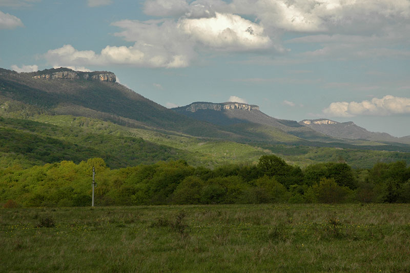
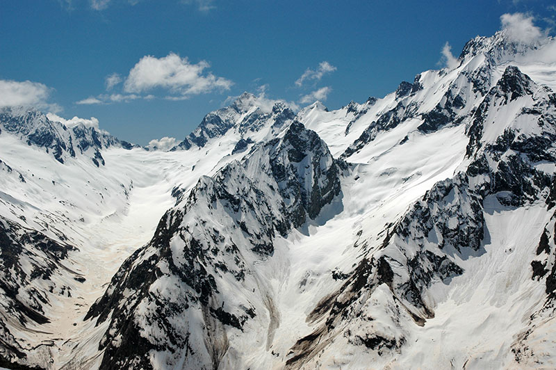
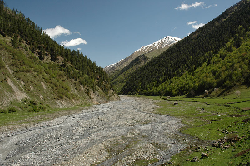
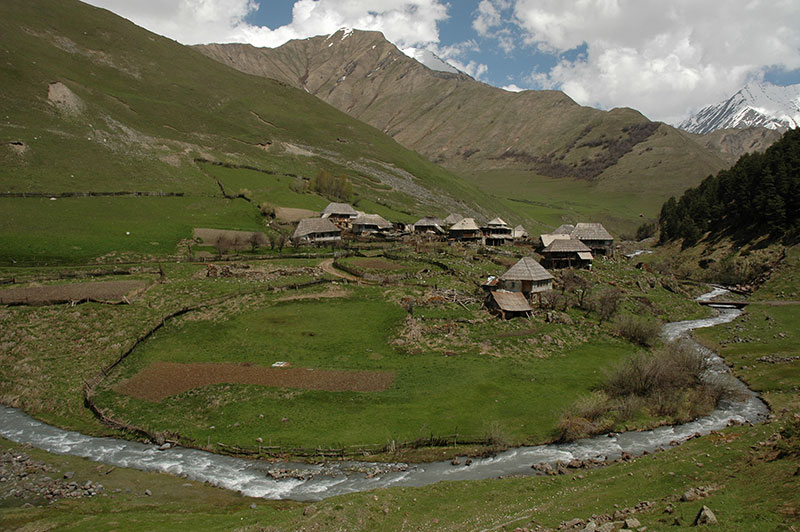
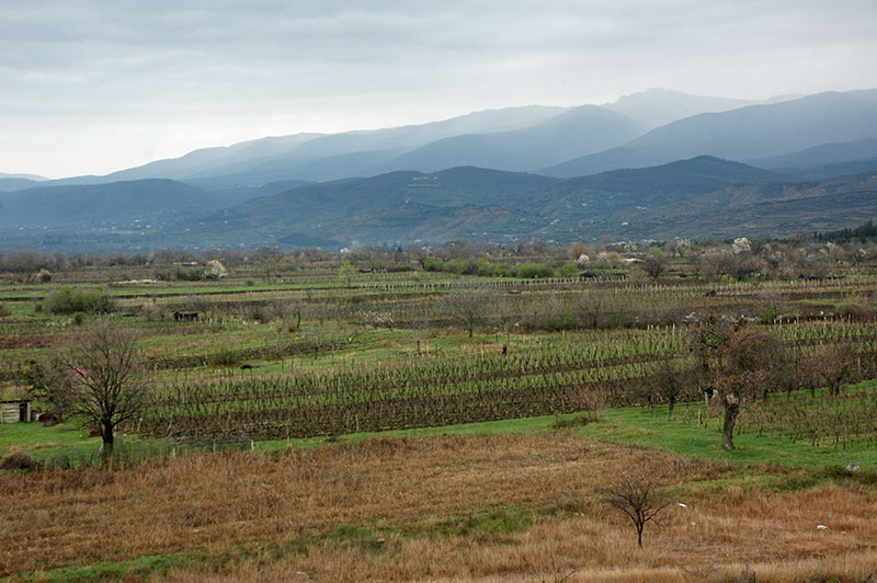
We all meet the following morning, and leave town in a convoy of three cars, heading initially west back to Alagir, then south, travelling back up the Ardon Valley from where I had just returned from South Ossetia. After a little more than twenty kilometres, we turn left, crossing the river and leaving the Trans-Caucasian Highway, winding up unpaved switchbacks, then over a forested ridge and come down to the hamlet of Dagom. Ruslan has chosen to strike camp at this site for its great natural energy, and the setting is undeniably magnificent. Located on a small outcrop, Dagom is backed by a large amphitheatre of lush green grass, high above the yawning Ardon Valley. Across the valley, the broad Tsey Valley opens up, running south-west beneath a ridge of jagged snowcapped peaks to the crest line of the Greater Caucasus. All around, bright limestone walls emerge from virgin pine forest, glowing warmly in the evening light. I can’t imagine many finer settings in which to camp.
In the morning, the air is perfectly clear, and I go to explore the hillside behind Dagom, which is dotted with ruined examples of the distinctly Caucasian Nakh style of architecture. While much has been reduced to rubble, Dagom must once have been a sizeable village, and its ruined watchtowers sit like broken teeth amongst rocky outcrops. Just as intriguing are the low crypts, which like the towers are built from large limestone blocks and lime mortar. Inside these crypts lie uncovered skeletons and bones, a tradition which suggests either that it was Nakh people (Ingush and Chechens) who inhabited these ruined settlements, or that the Ossetians inherited the burial customs of their neighbours.

Tsimity, North Ossetia-Alania Republic, Russia
After lunch and a short walk into the forest, Yuri, and Ossetian friends Georgiy and Sasha need to collect some supplies from the nearby town of Verkhny Fiagdon, and invite me to join them. We head east, over the 2200 m Arkhon Pass, and down into the town. While Yuri and Georgiy attend to business, Sasha and I head for the hillside behind town, on which lies another abandoned settlement named Tsimity. As we walk up the hillside, Sasha starts to tell me something of Ossetian history. The Alans mostly moved west into Central and Western Europe, and North Africa, contemporaneously with peoples such as the Goths, Huns and Vandals, around the time of the fall of the Western Roman Empire. Sasha tells me that the Alans even figure in British history, claiming that the legend of King Arthur is based on Alanian myths from the Caucasus. Certainly, there is considerable evidence that Caucasian and Celtic legends may have intertwined to create the story of King Arthur. As we approach the uppermost of the ruins in Tsimity, Sasha tells me that one of the towers was built by his family, several generations ago. Low grey clouds broil over the ridge-line above us, and a team of dark horses graze on the grassy meadow below. It’s intriguingly similar to the conjured images of Medieval England, and more interesting still to think that the Ossetians may represent a remnant culture of a race of peoples who are surely very widely disseminated into modern day Western Europeans.
The evening is spent around a large campfire on which dinner is cooked, and the Ossetians (principally Georgiy) are passing round spirt, which turns out to be neat alcohol. Against better judgement I take a shot. The stuff makes Georgian chacha at 60% taste rather watery; the spirt burns all the way down and sets off an internal ache which lasts for less than a minute but is sufficient to deter me from taking any more.

Necropolis, Dargavs, North Ossetia-Alania Republic, Russia
In the morning, I leave the group, who will stay on here for a week or so, and head east, over the pass and through Verkhny Fiagdon further east to what initially drew my interests to the North Ossetian mountains; the necropolis of Dargavs, colloquially known as the ‘City of the Dead’. To my surprise, when I arrive there are a bus-load of Russian tourists from Stavropol touring the site, but once they have departed I have the necropolis to myself. Consisting of 99 low crypts in the Nakh style, many with curved, ridged roofs reminiscent of the sikharas of classical Hindu temples, Dargavs is alleged to have been decimated by a plague, which explains the number of corpses still lying uncovered in the crypts, in various states of decomposition. It is even said that people who were the last of their families, would enter the crypts voluntarily and await their death. Whatever the story behind it, Dargavs is strangely fascinating in a macabre sense, and along with Dagom, Tsimity, and dozens of other abandoned settlements in the region seems to be evidence of great social changes in this region of the Caucasus.

Decaying Corpse, Dargavs, North Ossetia-Alania Republic, Russia
As I drive back down towards the Federal Highway, in order to return to Vladikavkaz, I have a very narrow escape with trouble. A police car drives past me in the opposite direction, which in my rear view mirror I see swiftly turn around and close in behind me with lights on. The North Ossetian traffic police have been perhaps the most corrupt I have encountered on my entire journey, but instead of inventing some petty infraction and demanding a pay-off as usual, they simply demand my passport, then get in their car and start to make a phone call. I know exactly who they are likely to be calling; the FSB in Vladikavkaz, perhaps the very people who had advised me to leave North Ossetia. Although I am presently unaware of the fact, the penalty for being caught in this region without a permit is a stiff fine, deportation from Russia and a ban on re-entering the country for five years. With plans to be in and out of Russia for the next eleven months, deportation would be a disaster for the Odyssey. By sheer chance, the police are unable to get a signal to Vladikavkaz, whereas I am able to call Alan and hand the phone to the police. To this day I have no idea what Alan said, but after talking for five minutes or so, the police hand me back my passport and drive off. Almost shaking, I speed down to the main road, pull out and put my foot down to blend in with the traffic. Moments later I hear a police siren behind me, and see another police car in my mirror. Thankfully, it overtakes me and I reach Alan’s home without further incident.
The Ingush Republic is my next destination and I say goodbye to Alan the day after returning from the mountains, and head east. The border is just twenty kilometres by road from Vladikavkaz, and is heavily militarised. I leave North Ossetia without a problem, but am immediately stopped at the police checkpoint of the Ingush authorities. A thuggish looking policeman with gold teeth leans out of the window, asks for my passport, then without even trumping-up any charge, demands a payment of two hundred roubles. I refuse, and am summoned into his office. Here the officer has a quick scan in my bag, then with a grin on his face points his pistol at me and demands money again. I refuse once more, and the officer makes further requests for me to take my trousers off, and then for me to pay him in order to shoot his machine gun from the back of his check post. I refuse each request, until he finally dismisses me, with a line of traffic forming behind my truck. I realise he is joking, but all the same it is a slightly shocking entry to his republic.
Once past the police, I am in the outskirts of the largest city of the tiny Ingush Republic, Nazran. The contrast with neighbouring North Ossetia is stark; one of the most abrupt changes in atmosphere I have come across without crossing an international border. Whilst Vladikavkaz is a calm, clean Russian city, hardly distinguishable from any other, Nazran is a wild and shambolic place more reminiscent of Pakistan. The Ingush speed along the streets wildly in battered Russian cars with blacked-out windows and blaring music, in flagrant disregard of any speed limit, then might half pull off the road and onto the verge to meet another car load of Ingush, shake hands and start business. Nazran looks recently built but often rather shabby, though the odd large luxury house hints at some distribution of wealth. It’s hard to believe that I am just twenty five kilometres from the tranquillity of Vladikavkaz, but I immediately warm to the place.
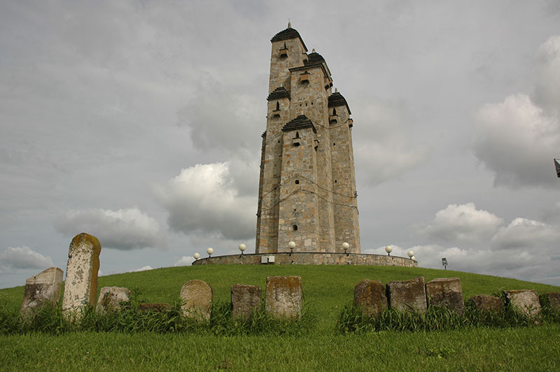
Monument to Stalin’s Repression, Nazran, Ingush Republic, Russia
Just to the south of the main highway, on the edge of Nazran stands a large modern structure in the Nakh style of the Ingush, consisting of a fusion of multiple siege towers constructed on a broad, shallow hill. Around the towers is wrapped a stylised band of barbed wire, and the perimeter of the grassy hill is surrounded by Ingush gravestones which had evidently been uprooted during Soviet times. The complex is a monument to the oppression of Stalin, who on the 23rd February 1943 accused the Ingush of collaborating with the Nazis, and deported the entire population to Central Asia and Siberia. More than half were though to have perished, in what many label as genocide. Upon returning from exile, surviving Ingush returned to find Russians and Ossetians living in parts of what the Ingush regarded as their land, deepening tensions between the two, which in 1992 erupted into yet another regional war shortly after the dissolution of the USSR, which was fought over the eastern environs of Vladikavkaz. With open Russian support, the Ossetians were victorious, but the conflict was most likely the root cause of the Beslan School hostage crisis, which is thought to have been perpetrated by largely Ingush hostage-takers.
From Nazran I continue east along the main highway which passes through a string of villages and residential districts, mostly consisting of low, modern houses on the grassy belt of undulating farmland which marks the transition from mountains to plains. I soon arrive in the town of Karabulak, where I am met by my Ingush host Yahya. Yahya brings me back to his home, where he lives with his extended family who are extremely welcoming. His wife and mother cook and prepare tea for us as we sit around the large kitchen table which seems to be the centre of the household. The Ingush (along with the Chechens) are a very ancient Caucasian nation, thought to have migrated from the Fertile Crescent around the dawn of civilisation. Once Christian, the Ingush were converted to Islam peacefully in the late eighteenth century and have a reputation as fierce mountain warriors. While I feel nothing but warmth and hospitality from my Ingush hosts, I am clearly in a far more traditional household than I have been in anywhere else in Russia.
Chechen Man, Grozny, Chechen Republic, Russia
Yahya also introduces me to his cousin Amir, whom I warm to immediately. His pleasant, smiling demeanour however betrays a rather tragic family history, and as I get to know Amir better, I learn of the struggles his family have had to endure which while shocking, are probably not particularly atypical for the region. Born a son of exiles in Kazakhstan in the 1950s, Amir’s father was returned to Russia like most Ingush in 1957, fourteen years after the initial deportation, and settled in Vladikavkaz. In 1992, when Amir was a child, his family lost their home in the conflict with Ossetia. Moving to Grozny, it was just two years before the same fate befell the family again; this time in the First Chechen War of 1994 when their house was levelled by the Russian Army. Today the family lives in small wooden house in Karabulak, though even this sleepy town is witness to a very active and ongoing insurgency, with almost weekly attacks and bombings targeting soldiers and officers, and kidnappings and murders by government security forces. A huge poster not far from Yahya’s house shows a sobering head-count of dead soldiers, with no such depiction of the number of Ingush – one of Amir’s cousins included – who have simply vanished. Despite the pleasant appearances, Ingushetia seems very much to continue the tradition of being a wild and untamed, yet beautiful and hospitable place.
Sadly much of this tiny ethnic republic lies in a restricted border zone and whilst waiting (ultimately fruitlessly) for a permit to visit the beautiful mountain villages of Dzheirakhsky District, I make a trip to Chechnya. I am picked up by a car full of Chechens on the main highway outside Karabulak, the driver of which, Zelim, is a friend of a friend of Karolina, whom I had met the previous month in Georgia. We are soon speeding along the highway at 160 km/h, through fields of poppies and lush green grass, blaring Chechen pop music and heading straight to the undemarcated border with Chechnya. Aside from a Russian Army post just inside the Republic, there are no signs of conflict, and the outskirts of Grozny are clean and pleasant-looking, with even the odd surviving Tsarist-era house.

Akhmad Kadyrov Mosque, Grozny, Chechen Republic, Russia
Despite some bullet-marks on older buildings, and the odd vacant lot, the impression Grozny gives is very much one of prosperity and modernity, with older Soviet-era apartment buildings smartened with cream-coloured siding and crimson rooftops, and a clutch of new luxury apartment complexes. On almost every street one sees posters of the Kadyrovs; late father Akhmad, swarthy and wearing a lambskin hat, and son Ramzan, the squat, boorish, red-haired current President of Chechnya. The seeming prosperity is of course largely the result of huge investment from Moscow, and in many of the street posters Kadyrov can be seen shaking hands with, embracing or even kissing President Putin. These touches of a personality cult, together with the smart (if rather sterile) air mean the city feels far more like one of the Central Asian capitals than anywhere else in Russia.
Zelim lives with his wife and small son in a modest detached house towards the edge of Grozny which has a more authentically Chechen village atmosphere compared with the modernity of the centre. After dark he takes me into town to what is without doubt the centrepiece of Grozny’s resurrection and rehabilitation from more than a decade of brutal civil war. The Akhmad Kadyrov Mosque is a huge, graceful and of course modern structure built in 2009 in the style of the finest Ottoman mosques, complete with a large landscaped park of fountains and walking paths. Even at 22:00 the area is still lively with groups of roaming Chechens in colourful, smart clothes and skullcaps lending it the feel of a mini-Mecca for North Caucasian Muslims; a good impression that the city’s restoration is more than simply aesthetic.

Chechen Highlands, near Itum Kale, Chechen Republic, Russia
In the morning Zelim drives me up into the mountains on a winding road through the foothills which for so long were the battleground between Chechen guerillas and the Russian Army. As in Grozny, the signs of war are few, and we wind ever higher into a magnificent landscape of sleepy villages and rolling, verdant beech forest. Out of this vernal woodland sprouts the occasional ancient Chechen siege tower, and upon reaching the town of Itum Kale we find a particularly fine example and climb up its internal stairways to survey the surrounding area; to the south lies a wide ridge still covered in snow, marking the Georgian border, whilst following the valley upstream for 30 km would lead to Dagestan. The owner of the tower finds us in its top room, and is pleasantly surprised to have a foreign visitor in his family’s ancient tower, which he has just finished restoring. The kind and good natured Chechens, the smart and tranquil city of Grozny, and the strikingly beautiful Chechen countryside are all a world away from the popular image of the Republic, and are testament perhaps to an effective peace process helped with huge investment and Kadyrov’s iron fist.
Returning to Grozny I bid farewell to Zelim and take a taxi back to Karabulak. Sadly my permit application has not progressed and so the following day I leave Ingushetia, saying goodbye to Yahya and his family, and to Amir, and drive myself back into Chechnya, past Grozny and on into the final, and perhaps most alluring of all the Caucasus Republics: the mountainous land of Dagestan. Crossing the Aksay River, I enter Dagestan, heading east towards the Caspian Sea. Wildflowers fill the grassy hillsides to the south of the road, and families are camped by the roadside in ancient Ikarus buses, selling honey to passing motorists. Huge, battered old trucks haul loads along this arterial road, bringing goods from the South Caucasus, Iran, Turkey and beyond into seething market towns such as Khasavyurt. Immediately Dagestan feels wilder and less organised than Chechnya with crowds thronging down litter-strewn market streets far more Asian than Russian in feel. Further east, the land becomes drier, even supporting a small field of wind-blown sand dunes as I approach the capital, Makhachkala.

Shepherd, Tsudakhar, Dagestan Republic, Russia
I have a brief run-in with the traffic police and FSB at a checkpoint on the city’s edge, but soon enough I meet my host Bagdat, a local journalist and museum employee who accompanies me back to his home. Dagestan consists of a patchwork of remote mountain valleys at the far eastern end of the North Caucasus, on the shores of the Caspian Sea. Unlike Chechnya or Ingushetia, Dagestan is ethnically very heterogeneous, with no nation forming a majority. Locals tell of 33 nations co-existing in this small republic, with Avars, Dargins, Kumyks and Lezgians making up the largest groups. Makhachkala has a slightly raffish and Soviet atmosphere with Russian being used as the lingua franca between the city’s many nations, and is far removed from the slightly soulless modernity of Grozny, but it is not a particularly interesting place. My host, Bagdat, is a member of the Lak Nation, and we have arranged the following day to visit the Lak District up in the mountains, far from the slightly muggy Caspian Coast.
Gunib, Dagestan Republic, Russia
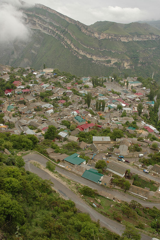
The two of us leave the following morning and drive for a short distance along the coastal plains, then turn inland at Manas and wind up through rambling villages with fantastic names – Karabudakhkent, Gubden, Levashi, Khadzhalmakhi, Tashkapur, many of which have Turkic origins. Rather surprisingly, the polyglot valleys of the interior of Dagestan are largely very peaceful, but it is in these lower areas where a Salafist insurgency is gaining momentum, often targeting the Russian authorities in Makhachkala and other coastal cities. The villages which I pass through are charming, with a timeless air, and are subtly different from any others in the region; despite the relatively good road links, the area feels splendidly isolated.
Our first stop is the historical aul (village) of Gunib, where Bagdat and I sample the local variety of khinkal, which varies in form across the region. Whilst Georgian khinkali are meat-filled dumplings rather like Central Asian manty, Gunib’s khinkal are served as lumps of steamed dough which are eaten with a large piece of meat in a rich sauce. We then visit the museum, a charmingly faded Soviet collection of folk items from around the region, including the decorated spoonboxes for which Dagestan is famous. Gunib also has a spectacular location, with the village perched on a small, flat shelf on the edge of a towering cliff, high above the muddy waters of the Karakoysu River. It made a natural choice for a fortress, the remains of which we drive through as we wind up the switchbacks behind the village, and it was here in 1859 that Imam Shamil, the last leader of the independent Caucasian Imamate of Avaristan was captured by the Russians, leading to total Russian domination of the North Caucasus in 1864. Before leaving Gunib, Bagdat and I visit a sanatorium where he spent a summer as a child in the dying, halcyon days of the USSR. This spectacularly beautiful, and historically and ethnically interesting region, once a magnet for tourists and hikers within the USSR now has something of a pariah status within Russia, and sees virtually no visitors.

Khosrekh, Dagestan Republic, Russia
Dropping back down into the valley, we return to Khadzhalmakhi, then turn south towards Bagdat’s native Laksky Rayon (Lak District), past dry, stony hillsides grazed by sheep, cliffs of white limestone and then deeply green valleys dotted with timeless stone auls and the odd minaret. In the district capital of Kumukh we visit an elegant stone mosque with small, coloured relief details around its sturdy stone windows, before arriving in the aul of Showkra, and the house of Bagdat’s grandmother’s uncle. Despite the remote location, driving on muddy tracks through stone villages, the house is modern and comfortable inside, and I am impressed by a large and full bookcase. After tea, Bagdat and I walk around the village, him fondly recalling childhood summers spent here and myself revelling in being in deepest Dagestan. I am warmly received by a group of older men who are sitting in a godekhan, a male-only half-open structure for sitting and chatting, like a very simple Turkish Coffeehouse. There is nothing like a coffee service here, though one or two of the men have clearly been enjoying some vodka. These are not the fierce, devoutly Muslim warriors who inhabit the hills of Chechnya and Ingushetia.

Lak Woman, Richa, Dagestan Republic, Russia
In the morning, after a wonderful sleep in the peace of the mountains, Bagdat and I continue south-east, climbing ever higher into the damp, grassy mountains, occasionally eroded into black slate scree slopes. We pass the impressive stone auls of Vachi, Kuli and Khosrekh, leaving behind any other traffic and climbing into the boiling cloud of the 2600 m Kokma Pass. From here the muddy track begins its steady descent back towards the coast, passing another swathe of traditional auls. First of the villages is Chirag, partly abandoned but with a vast, ancient graveyard spreading far up a sodden green hillside, its mostly rough-hewn megaliths reposing at various crooked angles. There are peculiar roadside monuments consisting of finely carved and painted gravestones housed in small stone altars. Most striking by far however, is a triple-tiered, three metre high whitewashed mausoleum, tied with colourful votive prayer rags and even a small female figurine, made entirely out of strips of material, which I assume to be some kind of fertility idol.

Richa, Dagestan Republic, Russia
Next is the aul of Richa, which is larger and more lively than Chirag. Flocks of sheep are being grazed by shepherds on the green hills around the village, from which torrents of runoff are pouring into the muddy river which the road parallels. Many of Richa’s overlapping, dark stone houses are built above vaulted passageways and tunnels, sometimes closed off by magnificent carved walnut doors, creating a maze of winding, muddy and deeply charming lanes whose walls are stacked with dung patties, used as fuel in this tree-less landscape. Towering above the village houses is the striking eleventh century stone minaret of a mosque built into the hillside, making this one of the most distinctive of Dagestan’s many auls. The locals whom I meet; men out grazing sheep and women out collecting water are surprised to see an outsider, but are immediately welcoming and hospitable. All these aspects make Richa a truly compelling place – one of the most enchanting in all of the Caucasus – and I am momentarily regretful not to have more time to stay here.
We wind down past more stone auls, past more megalithic graves and whitewashed roadside shrines, the land slowly changing, losing is harshness as we get closer to the warmth of the lowlands. We pass Tpig and stop in Khiv, populated by the Tabassaran Nation, famed for their extremely complex grammar. Here I see elaborately carved, rather phallic gravestones in walnut forests, overgrown with hemlock and other familiar weeds. Beyond Khiv the villages become more modern and less charming, though the scenery remains very pleasant as we drop onto the lightly-farmed plains around Kasumkent. It’s then just a short drive to the coast, to Derbent, the second city of Dagestan, where Bagdat takes an onward bus back to Makhachkala and I meet my Azerbaijani host Rishat.
Naryn Kala, Derbent, Dagestan Republic, Russia
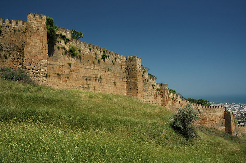
Derbent has long been a strategic entrepôt to the North Caucasus region, is said to be Russia’s oldest city, and is one which I very quickly fall in love with. With a cosmopolitan mix of Eurasian faces – dark skinned Lezgins and Azerbaijanis, Turkic-looking Nogays and pale skinned Russians, the sound of the midday azan (call to prayer), the buzzing of motorcycle rickshaws, pot-holed streets and piles of rubbish, colourful bazaars, muggy climate and air of neglect, all give it strong touches of the Middle East or Central Asia, and it feels very far removed from the cities of Russia ‘proper’. Dominating the city is the beautiful Naryn Kala, a Sassanian-era (Persian) fortress executed in warm yellow sandstone, overlooking the narrow coastal strip which it has guarded and controlled for more than 1500 years, connecting the Eurasian Steppe with Persia and the Middle East,

Gravestone, Derbent, Dagestan Republic, Russia
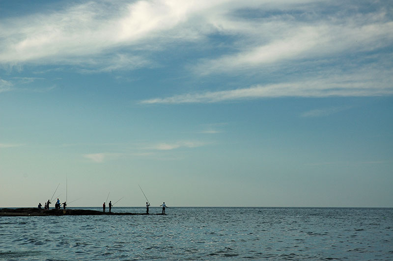
From the fortress, Derbent sprawls down to the coastline in a swathe of irregular sandstone homes, once bounded by the towering city walls, whose fortified gates are now minor traffic bottlenecks rather than staging points on the north-south trade routes. In amongst the roofs are signs of Derbent’s great ethnic diversity; a large Azerbaijani Mosque set in a courtyard of ancient chinar (plane) trees, an elegant Armenian Church, even a recently restored synagogue belonging to the tiny relict community of Mountain Jews. Immediately below the fortress, either side of the modern road linking Makhachkala and Baku, is a rambling medieval graveyard of magnificently carved sandstone gravestones, many two metres high or more, leaning at awkward angles or sometimes totally collapsed, testament to many centuries of inhabitation. The city gates have portals supported by Persian-style columns with fine muqarnas (corbels), now half buried, and there is even a very early Soviet building still sporting stucco mouldings of Marx and Engels. Long market streets run downhill towards the beaches of the Caspian where fishermen congregate on small rocky spits and cast their lines into the sea.
Even a brief run-in with the FSB, whom I am taken to by some good-natured crooked traffic cops after walking past their checkpost, is unthreatening, with the officers explaining that they are doing this as much for my own safety as for their intelligence. For the first time since Afghanistan perhaps, I feel as if I have ‘discovered’ a wonderful place for myself, having had no prior knowledge that the city would be quite as alluring as it is.

Azerbaijani Men, Derbent, Dagestan Republic, Russia
One afternoon, Rishat takes me to spend a night in his native village of Darvag, a few kilometres inland from the road to Makhachkala, set amongst rolling walnut forests overlooking the coastal plains where the mountains peter-out in grassy hills strung with ‘cognac’ producing vineyards, populated by ethnic Azerbaijanis and very different from the imposing stone auls of the interior. I am sadly too late to try the grilled hedgehog which his uncle has just finished eating, but at one of his neighbours’ houses, I do get to try some freshly made chudu, a baked pastry filled with minced beef and tripe.
Returning, I spend a final morning walking around Derbent before reluctantly parting with Rishat and this magnificent coastal city which has made for such a fine conclusion to my trip eastwards across the region. The road to Makhachkala passes towns such as Izberbash and Kaspiysk which are frequently targeted by insurgents, though the standard of local driving on the road strikes me as presenting more of a hazard. I stay in Makhachkala for a night with Bagdat, though his rather musty house sets off my allergies and I retire to the truck, parked in his driveway, at around 04:30.
Fishermen, Derbent, Dagestan Republic, Russia
At 05:00 I hear the first volleys of machine-gun fire. The police are blocking off the entrance to a nearby road in a UAZ, standing around nonchalantly, so I somehow dismiss the shooting as coming from an army barracks or other training facility. Before long however I hear exchanges of fire, and a bullet comes whistling over my position. Loud explosions can be heard, and people are running past the still-relaxed police at the end of the road. I hunker down in the cab and try to get a few hours of rest, but as dawn breaks there is no let-up. Bagdat emerges from the house and finds me in my car, and I ask him what’s going on. ‘They are shooting terrorists. Come in and have breakfast’ he says calmly. The shooting is still going on at 08:30, with plumes of smoke rising in the air, when I say a very grateful farewell to Bagdat – who has shown me the spectacular and rarely-visited interior of Dagestan.
I drive back towards the market town of Khasavyurt, then strike off north towards the vast Eurasian Steppe which occupies so much of this continent. Behind me the Caucasus, with all their beautiful scenery, fascinating ethnic diversity, convoluted history and troubled, sometimes warring nations very quickly recede and disappear into the summer haze. It would take far longer however for them to leave my thoughts.
Stage 20 – Russia & South Ossetia: The North Caucasus [1/2]

Russia. My first visit to the world’s largest country, on the outward leg of this journey had been a brief encounter, but one that had sparked a latent interest in this vast and enigmatic country. Neither Europe nor Asia, Russia perhaps best defines the term ‘Eurasian’ with its diversity of people and endless, glorious landscapes. Crossing into Russia from the breakaway Republic of Abkhazia marked the beginning of a year spent in-and-out of the country in an attempt to see a meaningful proportion of its regions. This particular stage of the journey would take me through the jigsaw of ethnic republics of the North Caucasus, no less troubled, factional and feuding than their independent counterparts in the South Caucasus, and no less scenically spectacular. The highlight however would be the people; from the Russians on the western coastline, to the myriad nations in the isolated mountain valleys of Dagestan, whose outright warmth and kindness defy the often bloody and tragic history of the Caucasus.
Black Sea Coast, Krasnodar Territory, Russia
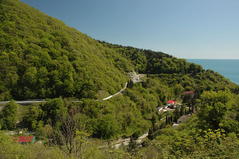
It’s the 28th April 2010, and I cross the bridge over the Psou River, crossing the notional Asia – Europe border, and entering Russia for the second time. It’s a refreshingly straightforward border crossing, though due to it being technically illegal, my passport is not stamped. I drive into the small coastal town of Adler, which seems years ahead of somnolent Abkhazia just down the road, and is not nearly as attractive. After staying one night I head north-west up the coastal highway, bypassing the city of Sochi where there are signs of massive building development, with huge tailbacks caused by the upgrading of this single traffic artery linking Russia’s premier coastal resorts with the rest of the country. Beyond Sochi the road becomes highly scenic, with hairpins and steep turns winding up and down over the forested coastal hills and across rivers emerging from them, with occasional glimpses out across the glittering Black Sea.
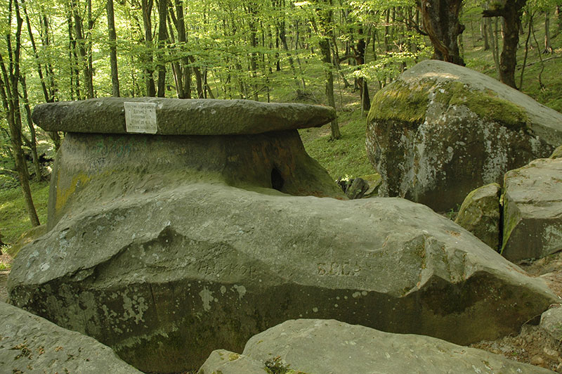
Dolmen, Tuapse, Krasnodar Territory, Russia
I reach the coastal town of Tuapse in the afternoon, where I am hosted by Alexandra and her boyfriend Max, who live in a ninth-floor flat overlooking the coastal hills. Tuapse, originally founded as a Greek colony is today more of a port than a resort, but a trip the following day into the hills a few kilometres inland reveals signs of a far more ancient history. We walk up into the ancient oak and beech forest which spreads up one bright green hillside, freshly erupted in the vivid, lime-green of spring. In this atmospheric woodland, amid moss-covered limestone boulders lie a number of dolmens; single-chamber neolithic tombs which are found in certain parts of Eurasia, and date from roughly the 4th to 2nd Millennia BCE, and whose origin and purpose are not fully understood. There are a particular concentration of dolmens in this western region of the Caucasus, and the example we are looking at, which is said to be roughly 4000 years old, consists of a single hollowed-out limestone chamber with a circular portal and a large slab roof. This intriguing and mysterious structure, which had clearly been a site of great importance to a long-vanished pagan culture, adds to the powerful natural ambience of the still, old-growth forest to give this spot something of a palpable atmosphere. Alexandra speaks of the site as one of great spiritual power and energy, telling me of miraculous conceptions to barren women inside the dolmen’s chamber. The low branches of nearby saplings are weighed-down with votive prayer rags attached by locals; evidence of the superstition and spirituality often present in the Russian soul, even today after decades of Marxism.
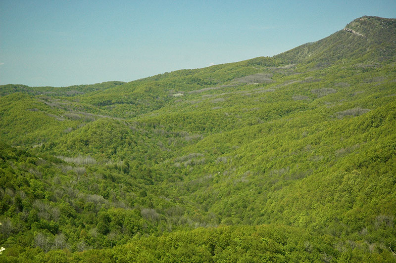
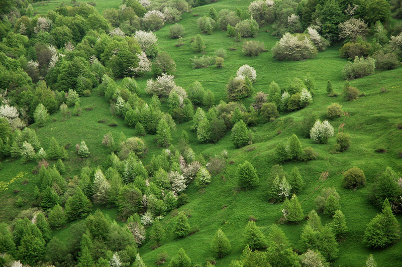
Forest, Krasnodar Territory, Russia
The road north-east out of Tuapse winds up away from the coastline, through the forested hills, past quaint villages of pastel-coloured wooden cottages with rambling gardens and picket fences; real village-Russia. Occasionally the trees part near the hilltops, revealing a sea of rippling forest which spreads to the horizon in a single shade of brilliant green, a magnificently beautiful and unspoilt natural landscape. At the top of one low pass, I enter the Adygea Republic, the first of the seven autonomous, ethnic republics which make up my route across the North Caucasus to the Caspian Sea. ‘Adyge’ is the endonym used by the Circassians to refer to themselves; an ancient Caucasian nation who may have been the architects of the region’s delmens millennia ago. Having been heavily subjugated and assimilated by the Russians in the nineteenth century, with many fleeing to Ottoman Turkey, the Adyge seem to lack the strong (and sometimes troublesome) ethnic identity of many of the region’s nations. Indeed, aside from the signpost announcing my entry into the republic, there is no obvious change from the quintessentially Russian villages as I roll down into the capital, Maykop.
Western Caucasus, near Kamennomostsky, Adygea Republic, Russia
I meet my host Marina in Maykop, and she suggests we meet some friends of hers who are celebrating today’s Labour Day holiday in the countryside to the south of town. We drive south through more undulating hills, to the outliers of the Caucasus which are dotted by limestone bluffs and craggy outcrops, joining the Belaya River which cuts a steep, narrow course through the wooded limestone hills. We drive up close to the end of the road at Guzeripl, and join a group of Marina’s friends in the forest; a group of jolly middle-aged Russian ladies who have evidently been enjoying the day with plenty of vodka and cognac, while their husbands abstain in order to drive. They’re sitting at picnic tables laden with food and drink, and I’m soon plied with sausage, chicken, salad, bread, tea and biscuits. We’re in a wonderful setting of fresh beech forest, whose floor is carpeted with crisp dry leaves, and alive with the sound of birds and the rushing water of the river. Around us are a number of Russian family groups who have set up more permanent camps with tents and washing lines; the Russians’ affinity for and comfort in the great outdoors, combined with near-endless unspoiled nature makes camping a very popular pastime here.
Lenin Square, Maykop, Adygea Republic, Russia
Once it’s dark, we head down towards a clearing in the forest where there is a small festival, passing a large tent playing standard Europop to amuse younger campers, to a small folk-music marquee. The songs, mostly solo acts, are all in Russian, but they’re simple, light-hearted ballads, and the participants are wonderfully unpretentious; nobody is taking themselves too seriously, and there is a genuinely friendly communal atmosphere. We all drive back together, stopping at one point for the ladies to sing from a bridge, before returning late to the deserted streets of Maykop.
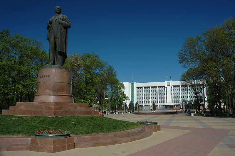
In the morning, Marina and her friend Olga give me a tour of Maykop, which is a neat, typical provincial Soviet city. Lenin still stands prominently in Lenin Square on his plinth opposite the Parliament of the Republic, which is decorated with bands of geometric patterns from nominally Adyge textiles as a Soviet gesture to the republic’s titular nation. Around the square are numerous manicured parks and lovingly-tended flowerbeds, and each street seems to have some bust or etching of a local ‘hero’. The street names are also pure Soviet; Krasnooktyabrskaya (Red October), Proletarskaya (Proletarians), Krestyanskaya (Peasants) and Pionerskaya (Pioneers) to name a few, stencilled onto small metal name-plates. It’s a pleasant, calm throwback to what I imagine were the nicest aspects of the USSR, a ‘village’ city where everyone knows each other, and where nothing ever happens. This is probably what caused one of the residents to call the police and report my truck – ostensibly on the grounds of having one wheel parked in a flowerbed – as suspicious. The local bomb squad had apparently been inspecting the underside of the truck with sniffer dogs, though we only catch one policeman who is leaving as we arrive. It’s somewhat understandable perhaps, in this comatose city which lies at the tranquil end of the volatile North Caucasus region.
Karachay Man, near Zelenchukskaya, Karachay-Cherkess Republic, Russia
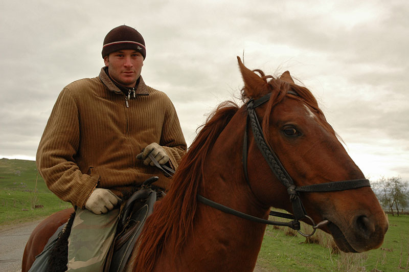
I leave Maykop and the Adygea Republic the next day, and continue east through fields of rapeseed and bright green wheat towards a distant horizon marked by mountains. In the afternoon, as I wind up into the damp foothills, I pass into the Karachay-Cherkess Republic, a dual-ethnicity republic whose titular nations are respectively Turkic and Caucasian, and which is markedly less Russified than Adygea. The change is quite abrupt; the villages are simpler, with ramshackle cottages surrounded by smallholdings, flocks of sheep grazing hillsides, men on horseback and cows wondering across roads. I stop in the town of Zelenchukskaya where I meet my host Aleksandr, and we drive together to his university dormitory in the village of Nizhny Arkhyz.
In the afternoon, Alexander takes me on a walk through the woodland to a tenth century Greek (Byzantine) church, one of Russia’s oldest and a postulated location of Maghas, the capital of the ancient kingdom of Alania which was destroyed by Mongol hordes in the thirteenth century. Also here is a balbal, an ancient, anthropomorphic menhir, the like of which may be found throughout Eurasia, and which hints at the Central Asian origins of the Sarmatian Alans, or perhaps the native Karachay, a Turkic tribe who came from the steppes of the east and settled this area in the eleventh century.
BTA-6 Telescope, Nizhny Arkhyz, Karachay-Cherkess Republic, Russia
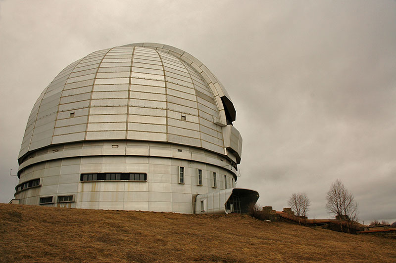
Alexander is a cosmologist, and the following day we walk up through the forested hills, which at this elevation are still bare and only recently released from their burden of winter snow, to the Special Astrophysical Observatory of the Russian Academy of Sciences, dominated by the Soviet BTA-6, which until 1993 was the world’s largest solid-mirror reflecting telescope. I am given a brief tour, though being an optical telescope there is nothing to see during the daytime. The overcast sky also hides the mighty peaks which lie a short distance away to the south.
Leaving Nizhny Arkhyz, I return to the main highway and into the east of the republic, turning south up another valley to the small, scruffy town of Teberda where I meet my host Aslan, a Karachay who has a traditional wooden house here where he stays when he is working at the nearby ski resort of Dombay as a ski-lift engineer. We join another Karachay friend of Aslan’s for dinner, and I’m reminded of the recent history of the Caucasus, a history which Russian’s often prefer not to dwell upon. They tell me how during the Great Patriotic War (as the Second World War is known in the Former USSR), the Karachay (among many others) were seen by Stalin to welcome the Nazis, and in November 1943 were accused of collaboration and deported en masse from their Caucasian homelands to the Gulags of Siberia and Central Asia. It is thought that 35% of the Karachay race was wiped out within two years, and it was not until the 1950s that survivors started to return from exile.
Greater Caucasus, Dombay, Karachay-Cherkess Republic, Russia
Aslan and I drive up to the end of the road in Dombay the following day, a small resort town which nestles in the steep folds of the Greater Caucasus at the foot of a huge mass of black rock, scoured by glaciers and eroded into sharp peaks, still blanketed in snow. Aslan and I are waved through the ticket queues for the ski-lifts by his friends, and are soon on a ridge at 2850 m. Here, Aslan makes a phone call to another friend, who picks us up in an Italian snow-groomer and drives us at an implausibly steep angle up to a peak at over 3000 m, where we are facing a huge wall of rock and ice, undoubtedly the most striking scenery I have ever seen in Europe, with Dombay nestled in a valley far, far below. Despite being several thousand meters lower than the Himalaya, the scenery around is nearly as impressive, and the combination of rolling green meadows fading into pristine pine forest with rivers of drinkably-clear glacial water, against the perennially snowcapped peaks make the High Caucasus just as scenic.
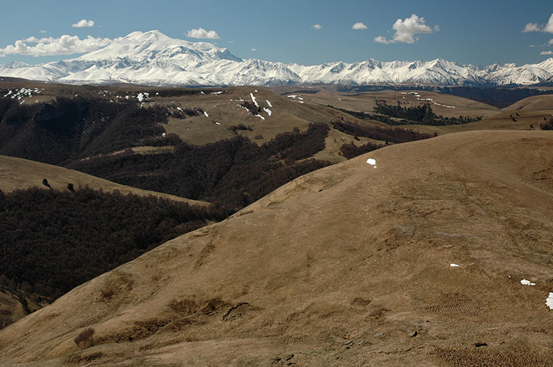
Mt Elbrus (5642 m), Karachay-Cherkess Republic, Russia
From Teberda, I head north-east, following a tip from Aslan to drive off the road at the Gumbashi Pass onto the Bichasyn Plateau. The morning is clear and the air dry but I’m unprepared for what greets me as I emerge from the pass onto a rolling expanse of parkland at 2100 m. Soft hills of grass still brown from the winter, dotted with patches of bare forest stretch back to a 150 kilometre-wide vista of the crestline of the Greater Caucasus, a sublime wall of snowcapped mountains. Almost 60 kilometres away, towards the eastern edge of this magnificent panorama, and significantly higher than anything else, are the huge twin-peaks of Mt Elbrus at 5642 m, the highest mountain in Europe. It takes over an hour to digest this view and tear myself away, but eventually I descend, passing the city of Kislovodsk, home to Aleksandr Solzhenitsyn, to the pleasant Russian town of Yessentuki.
I am hosted by Marcus, an Argentinian and Nadia, a local, who live in the city with their baby son Artur. Yessentuki is part of the Mineralnye Vody region, a popular resort renowned for its spring water which is sold throughout the country. Despite its proximity to the nations of the Caucasus, the region is almost totally Russian; from the window of the apartment, Mt Mashuk, near the city of Pyatigorsk is visible faintly to the east, at the foot of which Russian poet Mikhail Lermontov was famously killed in a duel. I spend a relaxing week with Marcus and Nadia, including the notable Soviet Victory Day holiday on the 9th May, which celebrates the surrender of Nazi Germany in 1945. Veneration of the Great Patriotic War was effectively a state religion during Soviet times, and the celebration continues today with parades of veterans and an orgy of Russian nationalism. Accordingly, we spend the day in the park drinking beers, and end up at the opulent home of one of Nadia’s friends, whose mother runs the largest brothel in town, for the ubiquitous Russian shashlik (kebabs) and vodka.
During this week I also finalise arrangements to briefly cross the Caucasus once more and enter the breakaway Republic of South Ossetia, which rather like Abkhazia last month, involves emails to the Foreign Ministry in the South Ossetian capital of Tskhinval. After initial confusion, I am granted access to visit their tiny republic, which is technically part of Georgia. I leave Marcus, Nadia and Artur early one morning, moving east once more. I’m soon held up in traffic as I pass Pyatigorsk on the M29, the old Soviet highway running from Rostov to Baku. As I leave ‘Russian’ Russia, and enter the Republic of Kabardino Balkaria, so begins a day of trouble with the notoriously corrupt Caucasian traffic police. Just outside the city of Nalchik, I run a concealed red light and am immediately chased by eagerly waiting police. At the border with the Republic of North Ossetia, I am directed to pull over at a check-point and then accused of crossing a solid white line. In the town of Alagir I’m pulled over by a policewoman and told that I “just went over the line, a little bit”, and finally, at around 15:00, as I drive up towards the South Ossetian border, after having eaten nothing all day and certainly not drunk anything alcoholic, I’m breath-tested positively at a checkpoint with an ancient Soviet device. In each instance, a straf (fine) is expected to be pocketed by the policeman, but in each instance I simply refuse and wait them out, before they get bored and send me off. These farcical pantomimes of law-enforcement are more wearisome and time-wasting than threatening, but they’re hardly enjoyable.

Roki Tunnel, North Ossetia-Alania Republic, Russia
In the town of Alagir I join the Transkam, or Trans-Caucasian Highway, which enters the narrow valley of the Ardon River, climbing between the soaring valley sides of beautiful grassy meadows dotted with the ruins of stone siege-towers and churches. The Transkam is one of only two roads crossing the Greater Caucasus north-to-south, a lifeline for the South Ossetians, a highly strategic conduit for the Russians, and a thorn in the side of the Georgians, for it was via the Transkam that the Russian Army supplied their forces in Georgia during the 2008 war. I pass the Russian border post at Nizhny Zarmag with little fuss, though once again my passport is not stamped, reminding me that I am technically entering Georgia illegally. Ten kilometres beyond the border post, still in Russia, I enter the Roki Tunnel which has been bored for 3730 m through the mountains, emerging in a wide amphitheatre of mountains in the de facto independent state of South Ossetia.
Ossetian Man, near Dzaw, South Ossetia
I’m flagged down by a few plain-clothed men, who turn out to be the South Ossetian border guards. My passport is taken and a phone call made to the capital; I mention the name of the minister with whom I had been in correspondence, and I’m soon ushered on my way. The landscape on the southern side of the mountains is broadly similar to the north, though slightly more open, and naturally further advanced in the transition from winter to summer. It’s a beautiful, sweeping descent in the afternoon to the capital Tskhinval, where I check into the shabby and decrepit Hotel Ireston.
The Ossetians are an intriguing ethnic group, descendants of the Alans, a Sarmatian tribe who in turn were the western group of the Scythians, a vast and enigmatic nation who inhabited much of Eurasia in antiquity, a time during which ‘Scythia’ represented a land beyond the frontiers of the known world. The Ossetian language is accordingly an ancient member of the Northeastern Iranian family, thought to be the only living remnant of an earlier, unknown Scythian-Sarmatian language. Today the Ossetians are squeezed in amongst the other nations of the Caucasus, though unusually are distributed both north and south of the Greater Caucasus range. With their distinct identity has come a struggle for recognition, which led to the creation of an autonomous South Ossetian region within Georgia throughout Soviet times. With the collapse of the USSR looming, the South Ossetians renewed their call for greater autonomy in 1989, leading to Georgia removing the region’s autonomous status, and the South Ossetians declaring full independence. When the USSR finally dissolved in 1991, these grievances erupted into yet another war in the Caucasus, one that resurfaced in 2008 with open Russian involvement, and has led to the existence of this tiny, largely unrecognised state.

Destroyed House, Tskhinval, South Ossetia
Tskhinval is visibly devastated, with damage from the 2008 war still clearly visible on the northern edges of town, where homes have been reduced to empty shells amid piles of rubble and the overturned, burnt-out bodies of cars. The centre of town has been largely rebuilt, but the place has more the air of a depopulated provincial town than a national capital. It’s noticeably less Russified than Abkhazia, feeling more like the rest of Georgia, though the people look more European. There is a strong army presence, with Russian Army trucks hauling muddied tanks back up the Transkam to Russia, and many men walking around in military fatigues, but the atmosphere is friendly and pleasant.
At the western edge of town lies the strangely restored railway station and beyond, the long-deserted, rusted lines which are starting to warp as grass and small fir trees push up between the old concrete sleepers. The old platforms are breaking up, covered in weeds, and the pylons are slowly tumbling down. Behind the railway lines is a long-stilled crane, and a few old warehouses with leaning chimneys and rusting old metal pipework. The area has clearly been moribund since long before the 2008 war; a poignant symbol of the isolation and decay which the region has obviously suffered since the collapse of the USSR.
Hillside, Kemulta, South Ossetia
There’s really very little to see or do in Tskhinval, so after two nights I turn back north again, slowly heading towards Russia. I have no real map of the area, and there is certainly no guide-book. The only information I have come across comes from the rather optimistic ‘tourism’ section of the website of the South Ossetian Ministry of Foreign Affairs, which has a series of surprisingly beautiful photographs of the republic which I decide to try to find.
In the village of Gufta, I take a rough side-track which leads to the western edge of the republic, winding up through beautiful, steep, green hillsides dotted with hawthorns and small, brush-like trees. Here, close to the border with Georgia ‘proper’ is Lake Ertso, a shallow lake in a grassy meadow which is apparently famous for disappearing completely, only to later return. Whilst not particularly striking, it’s a pleasant spot among rolling hillsides and mountains still streaked by the last of the winter snows, but is absolutely deserted.
Zgubir Valley, South Ossetia
Retracing back to the main road, I stop in the town of Dzaw, the second largest in the republic but in reality a village of around 1500 people. Apart from being the only place I have visited which sports bust of both Lenin and Stalin (Stalin’s home town, Gori, is only 50 km to the south), there is little going on, but the scenery becomes increasingly impressive as I continue north. In the half-abandoned village of Nizhny Rok, I turn east and into the Urstualgom Valley, the highest in South Ossetia. A churned-up dirt track drops down from the main highway, crossing a river and passing an old, ruined siege-tower, then slowly climbs to the east. At the village of Zgubir, a beautiful, wide river valley opens up between mountains clad with pristine pine forest which leads to the Russian border. The village itself – a few houses built on a hill – has an almost complete, but abandoned stone church with a rusting tin roof and birch trees growing from the steeple, which the friendly villagers tell me is Greek (Byzantine).
Edys, South Ossetia
The villagers in Zgubir also confirm that the ruined settlement of Verkhny Yerman, which the South Ossetian Foerign Ministry touts as the highest village in South Ossetia, lies at the end of the road, but tell me I must negotiate a Russian Army barracks en route. I encounter the army shortly after Zgubir, expecting to be turned away, but after simply showing my passport, I’m waved through and warned to stay on the main track, and not take any turns, indicating that I might be shot by the Gerogians. Soon after the barracks the road becomes a quagmire of muddy switchbacks which are barely driveable, but then levels out and reaches the tiny, isolated village of Edys, which is certainly the most idyllic looking place I’ve seen in South Ossetia. Situated within a wide meander of a small, fast-flowing mountain river, at the foot of snowcapped mountains, the dozen or-so homes of Edys are constructed entirely out of wood, with tall, steeply-pitched wooden-tile roofs overhanging wooden balconies. I decide to leave the truck near the village, and continue further on foot.
Gravestone, Nizhny Yerman, South Ossetia
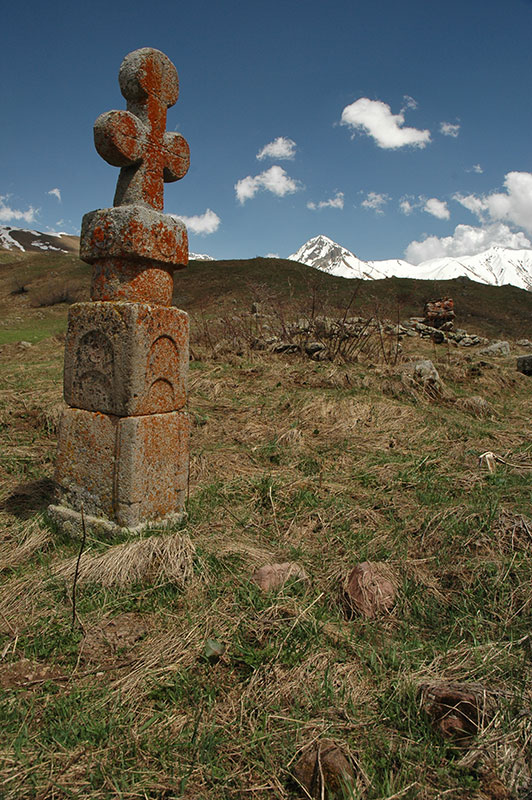
The track climbs through pine forest, passing cascades of volcanic tephra, then emerges into a double-headed valley surrounded by the snow-covered ridges which mark the border with Georgia. One lone wooden cottage sits in a valley to the south, but all around me are the signs of ancient settlements; foundations of rock walls and long-gone structures, and a plethora of tall gravestones covered in bright orange lichen, most leaning off-vertical and some totally fallen. They each bear a cross and are clearly Christian, but their totem-like form suggests an underlying pagan influence, like a Christianised evolution of the earlier megaliths also found in the region.
Climbing further into the valley to the east, I reach the nearly-abandoned village of Nizhny Yerman where the muddy track ends. Here are perhaps ten homes still standing, surrounded by a network of rambling dry-stone walls. One wooden structure has been built against an almost-complete stone siege-tower, the last remaining link with the stone ruins I see all around. Atop a small hill next to the village is a tiny stone chapel barely large enough for a man to crawl into, with a free-hanging bronze bell suspended on a pole connected to a conical cairn of stones. I speak to one man, who along with one other are the only souls I see in the village. He tells me that he now lives in Vladikavkaz, in (Russian) North Ossetia, and only comes here occasionally. Since the Russian government began to openly issue Russian passports to citizens of South Ossetia (and Abkhazia), it’s little wonder that so many South Ossetian villages are rotting away, as people leave this isolated and war-torn little republic to live in Russia.
Leaving the village, I walk further east into a treeless grassy valley, which is strewn with more ruins; stumps of siege-towers, toppled gravestones and crumbling stone walls. At 2400 m, it’s an intriguing ruin of what must once have been quite a sizeable community, something like Ushguli in Svaneti, Georgia. A few kilometres further, crossing a pass at the head of the valley would lead to the volcanic Kelsko Plateau, but it’s still deep in snow, I am out of supplies, and I am not even sure which country it technically lies in, so I return to the truck in Edys.
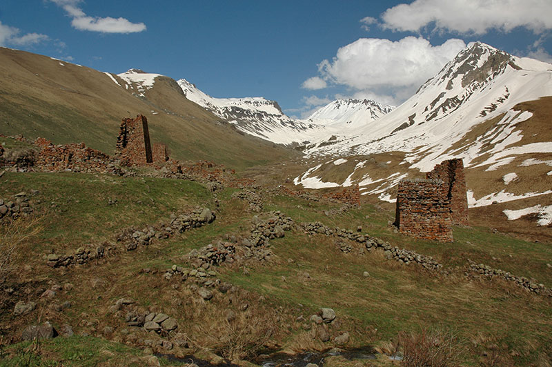
Ruins of Verkhny Yerman, South Ossetia
Next morning I return to Russia. Like all roads in South Ossetia, this one is a dead end, and so I must backtrack down the valley, past the Russian Army and back onto the Transkam, climbing the last few kilometres to the post at Vekhny Rok where the road plunges back into the Roki Tunnel, back into Russia and into Europe.
This first leg of my journey through the North Caucasus has been a warm re-introduction to Russia, to the western ethnic republics, and to the most striking scenery of the Caucasus. South Ossetia, whilst not technically part of the North Caucasus, is presently only accessible from the region, and has been a curious insight into this forgotten oddity of a country. Now however I have my sights set on the final leg of my journey through the Caucasus; across the remaining four republics to the Caspian Sea.
Stage 19 – Azerbaijan, Georgia & Abkhazia: The South Caucasus
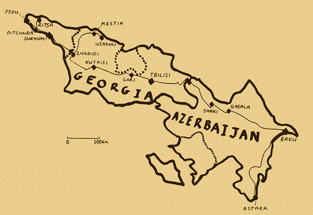
The Caucasus Mountains stretch from the Caspian Sea in the east to the Black Sea in the west, and mark the notional geographical border between Asia to the south and Europe to the the north. The term ‘east meets west’ is used far too often, but in the string of republics which lie on either side of this divide, the largely Muslim cultures of the east and Christian cultures of the west lie (often uneasily) side-by-side. The Caucasus are a patchwork of nationalities with a long history of feuds, internecine fighting and politically charged inter-ethnic hatred. For much of the twentieth century, the Caucasus lay almost entirely within the borders of the USSR, but as the huge empire began to topple in the late 1980s, numerous long-standing tensions resurfaced in a series of bloody wars, leaving wounds which remain fresh today. In this relatively small region are dozens of nations, and a complex jigsaw of borders, enclaves, exclaves, autonomous republics and no less than three de facto independent breakaway states.
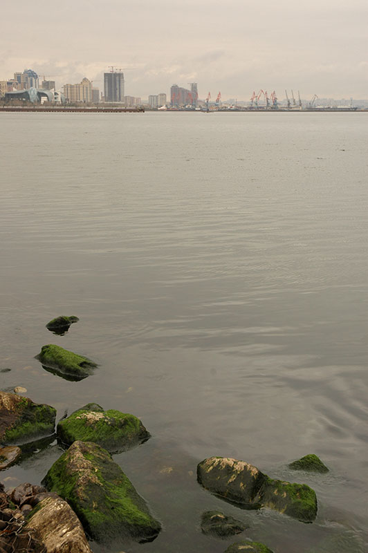
Waterfront, Baku, Absheron Region, Azerbaijan
It’s the 31st March 2010, and I enter Azerbaijan on a rainy afternoon, at the small cross-border town of Astara. I have a five-day transit visa, but strict vehicle import rules mean that the truck may only remain in the country for 72 hours. There’s a steady rain as I leave the border crossing and head north towards the capital. The low-lying ground along the shore of the Caspian is verdantly green and alive with croaking frogs, whilst my surroundings bear all the familiar touches of the former USSR; small houses with rustic gardens, shops with hand-painted signs, old Kamaz trucks, Ikarus buses, Soviet road-signs, patchy asphalt roads and plenty of nasty traffic police. Whilst being reassuringly Soviet, it does not appear on first impression to be as Russified as most parts of the former USSR.
The history of Azerbaijan is tied very much to that of Persia, though by the eighteenth century self-ruling khanates (tribal chiefdoms) had emerged, and in the nineteenth century the area formally switched from the Persian to the Russian Empire. Although the Azerbaijanis speak a language quite similar to modern Turkish, they are a mixture of Caucasian and Iranian people, further mixed with later Turkic migrants from the time of the Mongol Empire. While culturally strongly Turkic, the centuries of Persian rule persists in their adherence to Shi’ite Islam. Azerbaijan gained brief independence in the turmoil which followed the 1917 Bolshevik Revolution, but in less than two years was absorbed into the USSR. Lasting independence came once more in 1991, and the country (or rather a small elite of the country) has since quietly prospered with the revenue of its considerable hydrocarbon wealth. A father-to-son dictatorship, Azerbaijan has done noticeably less than neighbours Georgia and Armenia open up to foreign visitors, and the country is deemed to be highly corrupt, even by regional standards.
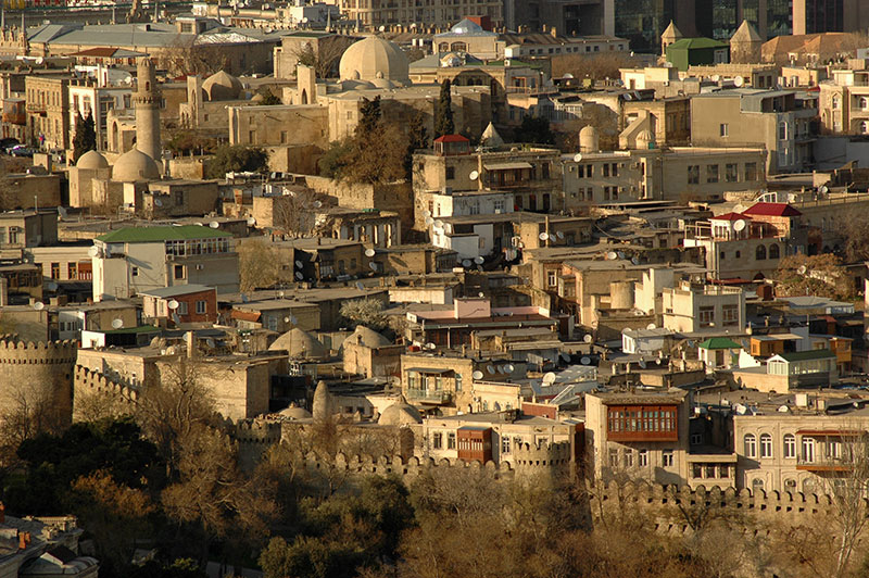
Old City, Baku, Absheron Region, Azerbaijan
It’s dark and pouring with rain by the time I reach the capital Baku, where I am hosted by Kyle, an American Peace Corps volunteer who has opted to stay on in the country. Baku is the world’s lowest capital city, located on the oil-rich Absheron Peninsula 21 metres below sea level, and is probably Eurasia’s oldest oil boom-town. Even during Soviet times, Baku was known as a prosperous city, something which becomes apparent as I explore the following day. The city ‘centre’ is located on the damp Caspian seafront, with a long, curving promenade of grandiose 19th and 20th Century buildings, all constructed from fine, buff-coloured sandstone. With the gaping inequality and corruption; late-model black SUVs screeching down streets where old widows rifle through litter bins, the grandeur is somehow lost however, and what might be an elegant and chic city reeks more of the vulgarity of the nouveau riche. The streets are filled with posturing youth attempting to look wealthy and urbane in cheap Chinese copies of western fashions, and the traffic police are out in force with their glowing orange batons, shaking down passing motorists who don’t appear rich enough to have connections in the police. I fail to warm to the place.
Behind this ostentation lies the Old City, which in corners is pleasantly rustic but seems just a little too restored and manicured to have any real historical atmosphere. It’s a pleasant place to walk though, down narrow streets of two-storey sandstone buildings with overhanging balconies of wooden canopies or wrought-iron railings in the midst of which is the occasional blocky sandstone mosque with elegant Persian-style portals. Further Behind this lie the large, newer suburbs of the city which grew up during Soviet times, and are presently being added-to with luxury apartment complexes. Here I catch a glimpse of real life as I sit in a small café full of jolly daytime drinkers, staffed by plump middle-aged women in pinafores who stir large pots of Soviet stolovaya (canteen) food. I could be just about anywhere in the former USSR, but there is a noticeable absence of Russians, even when compared to Central Asian cities such as Tashkent or Bishkek. It’s a reminder of the inter-ethnic wars which followed the collapse of the USSR, part of Russia’s long standing troubles in the region.

Greater Caucasus Mountains, near Qabala, Daghlig Shirvan Region, Azerbaijan
I leave Baku the following day, heading north-west, closing in upon the mountains. The road climbs immediately when leaving the capital, and winds up onto a plateau of fresh green grass, undulating over the ripples of outliers which are divided by wide, muddy, boulder-strewn river beds. From one of these ridges I catch my first glimpse of the crestline of the Greater Caucasus range; a sharply-defined, distant ridge of snowcapped rock which marks the border with Russia and Europe. I pass through delightfully bucolic farming villages with trees that are just erupting into full spring bloom and bushes of fresh white blossoms. After so long in Asia’s deserts and mountains, it’s a pleasure to see a real spring, and I realise that even Azerbaijan feels very European with its pretty villages, tree-lined avenues and European flora and fauna such as brambles and blackbirds.
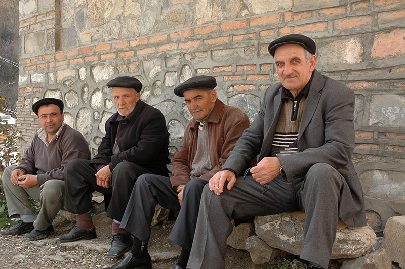
Azerbaijani Men, Shaki, Shaki-Zaqatala Region, Azerbaijan
It’s a pleasure to drive through such beautiful vernal countryside, through small villages of single-storey stone houses and whitewashed walls, and provincial towns such as Qabala and Ismayilli which have a strongly Caucasian, rather than Soviet character, and are a world away from the brashness of Baku. I stop for the night in the town of Shaki, which nestles in a fold of mountains marking the border with Dagestan, and was an important city in the ancient kingdom of Caucasian Albania. The steep and winding streets are lined with smart, brick and stone buildings, with flourishes of Persian influence evident in the highly decorated Khan’s Palace and an elegant, restored old caravanserai. The place feels quite Turkish, with men sitting in cafés and on doorsteps playing nard (backgammon), smoking and drinking tea. Walking up a nearby hill one sees perhaps the best view of the town; a sea of terracotta-tiled rooftops pierced only by the occasional minaret.
I have to leave Azerbaijan the following day, and so leave Shaki in the morning, continuing through Zaqatala to the border town of Balakan, which seems a popular spot for begging gypsies. A few kilometres north of town I slip out of Azerbaijan, 71 hours after entering, and enter Georgia.
Vineyards, near Badiauri, Kakheti Region, Georgia
I can’t remember the last time I entered a country for the first time and was so immediately impressed with it as I am when I enter Georgia at the small border crossing at Lagodekhi. Georgia is one of the oldest Christian states, and has largely resisted the Persian and Turkic empires which have long surrounded it, even driving out the Mongols in the thirteenth century after a short occupation. Georgia corresponds roughly to the kingdoms of Colchis and Iberia in antiquity, and is thought to be home to the Golden Fleece which Jason and the Argonauts sought. Christian since at least 337 CE, Georgia has existed through time as a series of kingdoms which were ultimately incorporated into the Russian Empire in the eighteenth century. Georgia has had a shaky start to independence, with wars, refugees, economic chaos and rampant corruption and crime, but has recently staged a striking renaissance with transit revenue from the Caspian – Black Sea pipeline (exporting oil from the Caspian to Europe without crossing Iran), and the eponymous and sometimes controversial pro-Western president Mikheil Saakashvili, who is widely lauded for cleaning up the country and inviting massive foreign investment.
Street, Tbilisi, Georgia
I’m slightly puzzled by the EU flag which flies at the Georgian border post, but soon realise that it is merely aspirational, or perhaps a provocation to the Russians. Georgia is the first country in almost three years for which I don’t require a visa, and entry procedures are brief and friendly. I’m soon driving through the damp countryside of Georgia’s Kakheti Region, whose rolling landscapes are dotted with old stone forts and churches, and lined by vineyards and muddy villages of wooden homes. Everything around me is at once familiar, friendly and un-ostentatious, and lacks Azerbaijan’s air of corruption; I’m immediately impressed by the country.
I reach the Georgian capital Tbilisi in the afternoon, where I am hosted by Murdoch, a Kiwi writer whom I had met in Pakistan last year, who lives with his girlfriend Sarah in an apartment in the upmarket district of Vake. Tbilisi is immediately endearing with its ramshackle Old City of decrepit town houses and charmingly faded streets. The central bazaar is alive with commerce, and there is a positive and upbeat air. The city lacks any real pretentious atmosphere, but manages to be suave and even sophisticated. It’s not given over to soulless commercialisation, though is neither squalid nor seedy. As a capital, it’s one of the most charming cities I can remember being in, and I soon feel that it is a place in which I would be happy to live.
Walking up a hill in the west of town, one sees a wide panorama of the city; a sea of low red rooftops amongst labyrinthine old streets. The centre is mostly devoid of ugly new buildings, and the Soviet concrete monsters are relegated to the city’s edge, leaving a largely intact ancient historic centre. To the south, remnants of the city’s medieval walls are draped over long, green hills, and everywhere the city’s roof-scape is dotted by the low, fluted conical spires of Georgian churches, which seem to have survived the repression of Soviet times in great number. Beyond the city limits the Greater Caucasus begin, giving a dramatic mountainous backdrop to this homely and pleasant city.

Tbilisi, Georgia
Tbilisi’s clean atmosphere is helped by the reforms which have been made to the police force. Strong anti-corruption measures have led to a paradigm-shift in the country’s police. Unlike most post-Soviet countries, the Georgian police force is changing from a militia, that is, a force designed to harass and keep watch of the public, to a police force which exists to serve and protect the public. I almost feel sorry for the police, who seem like toothless old dogs compared to their bribe-hungry regional counterparts.
The Georgians themselves are as equally beguiling as their country, with the warmth and laid-back joie-de-vivre of Asians, but also the rationality and worldliness of Europeans. They are rather like Russians in this respect (a compliment few Georgians would appreciate), though further lack their stoicism and tragedy. Georgians will fervently cross themselves when passing anything remotely religious, but they’re hardly bloody-minded fundamentalists. They strike me as particularly easy people to get along with, though many of their neighbours would vehemently disagree; this is after all, the Caucasus.
Tbilisi is so perfect that I easily while away a week here, wandering the city and stopping in plenty of bars to watch life go by. I do however need to find a way to Russia. With the Georgia-Russia border closed to outsiders, my only hope (aside from an expensive ferry or a very long detour) is the breakaway republic of Abkhazia. After initially being refused entry, I make some tense phone calls and eventually speak to someone high-up in the Abkhazian Foreign Ministry, who grants me access to drive over the Inguri River and into Abkhazia. My route into Russia is thus opened ahead of me.
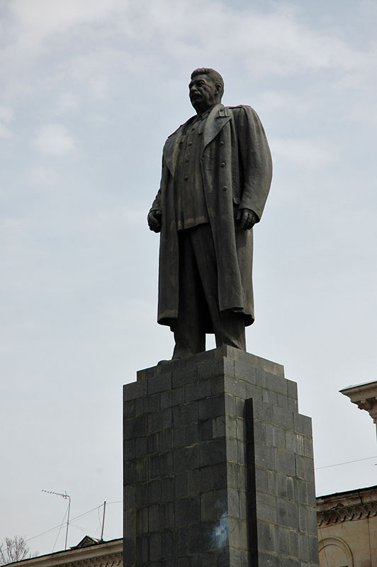
Stalin, Gori, Shida Kartli Region, Georgia
Murdoch and I set off one morning, heading west. We stop in the town of Gori, birthplace of Ioseb Besarionis dze Jugashvili, better known as Soviet leader Josef Stalin. In the centre of town, near his preserved childhood home, stands a large, imposing black statue of the man. Having survived Khruschev’s de-Stalinisation, it seems a slightly odd relic in a country so avowedly anti-Russian and pro-Western, surviving by the sentiment of local residents. The monument was in fact demolished two month later.
We head further west, along the southern border of the breakaway republic of South Ossetia, which since the 2008 war with Russia has been a tense cease-fire line, making the de facto independent state inaccessible from the rest of Georgia. From Gori, the road winds further west, though steep, rolling green hills dotted by wooden farmhouses and small fields. We stop for lunch in Kutaisi, the historic capital of Colchis, then descend towards the Black Sea to the town of Zugdidi, close to the cease-fire line with Abkhazia.
Leaving Zugdidi the following day, we drive north and are soon looking at a magnificent view of the mountains; a great wall of snow-covered rock rising up to the north. The road initially follows the Inguri river, then deteriorates in quality as it starts to climb through forest, eventually opening to wide, grassy meadows and mountain villages. The landscape here is just emerging from winter, and at one point a huge mudslide has made the road impassable, necessitating a tow from a bulldozer which is driven by the mayor of the nearby town of Mestia. Whilst waiting at the mudslide, we had been invited by a local to stay at his home, something we are glad to do when we arrive in Mestia in the late afternoon.

Svan Man, Mestia, Samegrelo-Zemo Svaneti Region, Georgia
Mestia is the capital of the region of Svaneti, a historic, mountainous province of Georgia inhabited by the Svans, who are an ethnic sub-group of the Georigans. In addition to mountainous scenery, Svaneti still retains dozens of characteristically Caucasian siege towers; tall, fortified structures which dot the villages that cling to the mountainsides, and were used for protection in times of war, something also evidently characteristic of the Caucasus. Although Mestia offers plenty of well-kept towers, it still has the feel of a small town rather than a mountain village, and so we leave after two nights to the farthest point of the Inguri Gorge; the villages of Ushguli to the east, which lie under some of the highest peaks of the Cacuasus.
The drive to Ushguli is a marvellous piece of alpine driving, as the snowmelt turns the road to mud, with rivulets of water streaming down the road surface. We have a brush with disaster shortly after leaving Mestia as, whilst driving up the valley side, two huge boulders drop down from the hillside onto the road, one stopping dead and one bouncing off into the valley below, both just metres from the back of the truck. What follows is hours of slow, slippery mountain track which hugs hillsides at awkward cambers, and crosses rocky riverbeds churning with snowmelt. The truck handles it all with ease, but it’s the longest period I’ve yet had to keep it engaged in four-wheel drive.
As evidence of the gruelling road conditions, the most precarious parts of the road are dotted by small shrines; open wooden boxes each on a stake driven into the ground, containing a photograph of someone who most likely plummeted to their death in the valley below, and a bottle of chacha (fiery Georgian pomance brandy) and some small glasses. We stop at one such shrine to toast the deceased, each taking a shot of the clear, slightly yellowish liquid. At around 60% alcohol it burns the throat (for a moment I wonder if it’s not petrol), but we make better time afterwards, despite the treacherous mud.
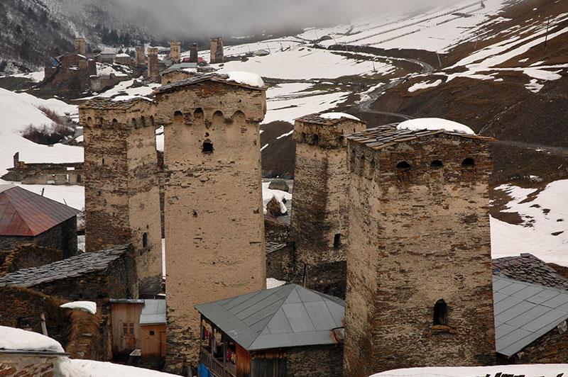
Chazhashi, Samegrelo-Zemo Svaneti Region, Georgia
We find a homestay in Chvibiani, one of the villages which make up the greater settlement of Ushguli. Outside, the clouds roll down and snow is falling once again. Nevertheless, fortified with more chacha from our hosts, and donning a pair of rubber boots, I slide up through the quagmire of mud and manure which passes for a street (and in which the truck is parked), then walk up a nearby hill through snow in places more than a metre deep. I find a good overlook, and as the clouds swirl and lift slightly, the snow stops and I’m left with a view down the valley to villages of Chazhashi and Murkmeli, which look to be straight out of medieval Europe. Squat, austere village houses with open upper floors and ornately carved wooden balconies nestle among tall, imposing siege towers with gently pitched slate roofs. Fierce, bored sheepdogs bark, and pigs root in the mucky alleys between buildings, but barely a human soul stirs. It’s the end of a long winter, during which life must all but stop in this high community. It’s a wonderful scene, and one of my favourite moments in Georgia.
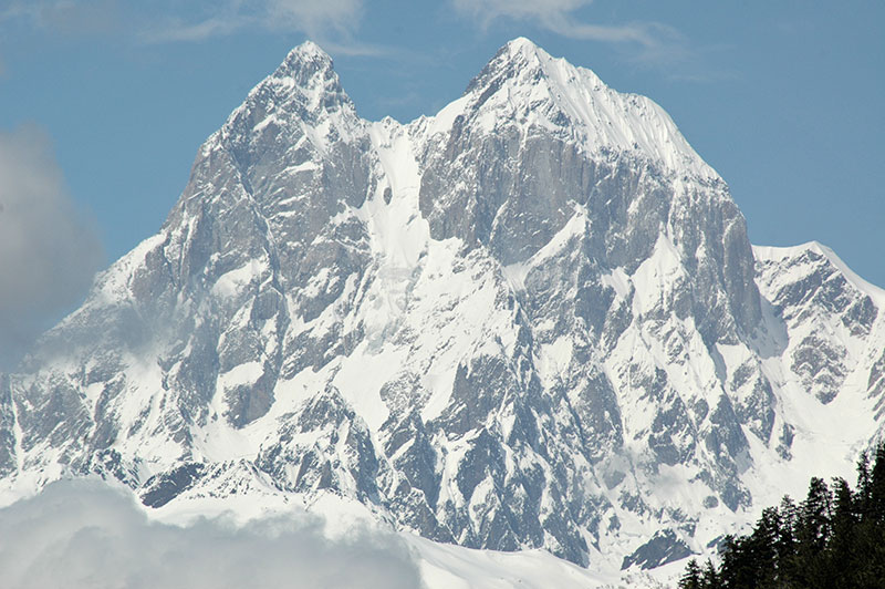
Mt Ushba (4690 m), Samegrelo-Zemo Svaneti Region, Georgia
We return to Zugdidi the following day, from where Murdoch returns to Tbilisi and I stay a couple of days preparing the truck for crossing the Russian border. On the evening before my departure into Abkhazia, I meet Karolina, a Polish volunteer who lives in the town, and I delay leaving Georgia by a couple of days. I must leave the country however, as I have been very fortunate to have been given permission to drive through Abkhazia and on into Russia. I leave Zugdidi one morning to the heavily policed bridge over the Inguri river. Here the Georgian police seem surprised by my letter from the Abkhazians, which gives me permission to enter by car, but after asking me to write and sign a disclaimer explaining that the Georgian authorities take no responsibility for my safety whilst in Abkhazia, they let me pass.
With a wonderful, welcoming atmopsphere, a very pleasant capital, stunning mountain scenery and endearing people, it’s really difficult to find fault with Georgia. The only annoyance has been the totally indecipherable alphabet, but that is merely my own ignorance. There is one thing however which worries me about the country; the nagging doubt that its untouched, unpretentious charm may merely be a brief snapshot of a country in flux, rather like the first signs of spring. On its current, western-oriented path, will Georgia surrender to the soul-less modernising uniformity which pervades much of Europe? Or will Georgia perhaps come under Russian influence once again, and return to a more reclusive state of corruption, like neighbouring Azerbaijan?
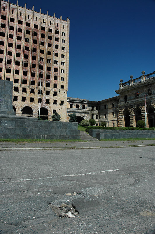
Parliament Building, Sukhumi, Abkhazia
Reaching the far side of the Inguri river bridge, the Abkhazian officials seem surprised to see me, but upon presentation of my letter from the foreign ministry, I’m allowed to enter without even having my passport checked. It’s a grey and dreary morning, which seems to amplify the dereliction and devastation I see around me; a devastated road leads slowly through a dank landscape of abandoned, crumbling and rotting homes; presumably the homes of Georgians, vacated during periods of ethnic cleansing by Abkhazian forces in 1992-3 and 1998. Gali seems to be hanging on the edge of existence, only partly inhabited, with the chorus of croaking frogs enjoying the rain the liveliest thing in town. There is a heavy Russian military presence in the area including patrolling helicopters, and I’m stopped by the Army, who are very polite, but thoroughly search the car.
I get my first glimpse of the Black Sea shortly before the town of Ochamchira, where the road improves markedly, and life returns to some semblance of normality. Despite the obvious signs of depopulation and destruction, one cannot fail to notice just how beautiful the coastline is; with a turquoise sea lapping against clean, pebble beaches lined with palm trees and pines, which continue on into the lush foothills. I reach Sukhumi, the capital around lunchtime, and head to the foreign ministry to pick up my Abkhazian visa, which comes as a loose piece of paper rather than being stuck in my passport.
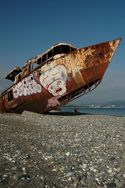
Beached Ship, Sukhumi, Abkhazia
Sukhumi has a gorgeous location in the mouth of a broad valley, and spreads up into the hills amidst a patchwork of emerald forest. The city still clearly bears the scars of war; whole residential districts of crumbling, bullet-pocked apartment buildings, and plenty of open lots which have gone to seed, with trees sprouting through old asphalt. The old, classical Soviet railway station is unused, leaving a decrepit network of trolleybuses as the only civic transport service. The centre is smarter with a pleasant, palm-lined seafront and several new hotels, but the city’s largest building, the thirteen-storey parliament building, remains a burnt-out skeleton with an empty plinth out front, most likely inhabited by Lenin in times past.
The liveliest part of the city is of course the bazaar, where I sit in a small café for a lunch of basic Russian fare. Here men walk in from the bazaar, take 100 grams of vodka at the counter and walk out wincing, back to work. Unlike Georgia, there are plenty of Russians here, amongst the Abkhazians, Armenians and others who live here. It seems rather like a time-warp back to the USSR; there is no real assertion of national identity that I can feel, certainly not when compared to other newly-independent republics of the former USSR, and the atmosphere is very unlike that in Georgia. An old, forgotten mural near the bazaar shows the classic Soviet image, of three multicultural workers with their tools; but this isolated and half-ruined throwback of a country seems to be a perfect example of the flimsiness of Soviet ethnic harmony, in the Caucasus at least. With the Union toppling, long-standing resentment at ‘Georgianisation’ among Abkhazians erupted into a horrific civil war in 1992, which has left the former autonomous republic isolated and near-destitute. It’s not easy to see what the Abkhazians have gained by chasing all the Georgians out, and I wonder whether this was a conflict stirred up by the greedy and power-hungry, or if it really was an expression of the hatred of one ethnic group for another.
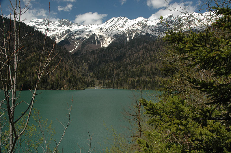
Lake Ritsa, Abkhazia
My impressions of a lack of nationalism come perhaps from the large assimilated Russian population, but these are shattered when I meet my first Abkhaz; Gioni, Georgi and Dima, who invite me for a Turkish coffee when I meet them on a seafront bench. Shocked to hear that I have come from Georgia, Gioni begins waving his fist in the direction of Tbilisi; “Fuck you Georgia!” he shouts, “They have caused this; this destruction, desolation and isolation”. These sentiments aside, they are warm and friendly guys, keen for the outside world to see their beautiful, once famous, now forgotten homeland. “Tell your friends to come”. With no airport, it’s hard to imagine many foreigners flocking through Russia or arguing with the foreign ministry to enter through Georgia to this admittedly beautiful slice of coastline, though Abkhazia has become popular once more with Russian tourists looking for a cheaper alternative to Sochi or the Crimean. The guys quickly rebuke any comparison between Abkhazians and Georgians; ethnically, linguistically or physically, but are curious to hear about Georgia. It’s difficult to compare Abkhazia with what is currently one of the most progressive countries of the former USSR, so I merely concede their point that it is indeed different.

Spring Flowers, Bzhyb Valley, Abkhazia
After four nights in Sukhumi, I continue my drive up the coast, with the signs of destruction becoming ever fainter with proximity to Russia, and the scenery becoming ever more beautiful. With bright green, forested hills and clear blue rivers cascading down towards the turquoise sea, it’s easily as beautiful as the Mediterranean. I take a side road which winds north towards the mountains, first tracking the crystal-clear Bzhyb river through a towering limestone gorge, then climbing through green forests of beech trees and pines amid a sea of yellow wildflowers to the beautiful alpine Ritsa Lake, with blue waters of glacial melt surrounded by steep, forested hills, and backed by the most westerly snowcapped peaks of the Caucasus. It’s an idyllic spot, one that Stalin also clearly enjoyed, for his dacha (holiday house) lies at the far end of the lake. It is here that I begin to see why Abkhazia was so coveted by Soviet leaders, and why it was the most exclusive of the USSR’s holiday spots. It really is one of the most beautiful places I have ever seen.

Seafront, Pitsunda, Abkhazia
Returning back down the gorgeous valley in the late afternoon, I drive all the way to the coastline and the delightful little resort town of Pitsunda, another favourite holiday spot amongst Soviet leaders. After dinner in a café playing 1980s music, I drive out to the beach and watch the sunset from the pine forest which comes all the way down to the sea. I can’t remember the last time I’ve been somewhere as perfectly tranquil and beautiful as this.
Early next morning I walk along the pebbly shore, which has not been ‘developed’ in any way since Soviet times. From the thick pine forest sprout three large fifteen-storey hotels, as elegant as any Soviet structures I’ve seen, with roof bars overlooking the sea, where dolphins jump in schools just off the coast. Pitsunda must have been the holiday spot of the Soviet elite, enjoying the warmth and beauty after the alternately freezing and sweltering depths of the Eurasian continent. It was indeed here in Pitsunda, in 1964 that Nikita Khrushchev received a call from Brezhnev summoning him to Moscow, where he was forced to resign the following day.
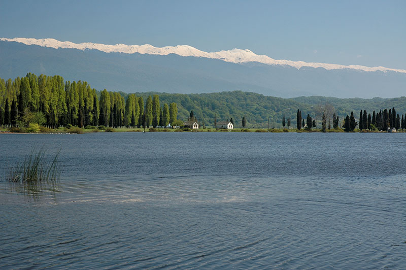
Inkit Lake, Inkit, Abkhazia
Pitsunda has one last delight, as I drive back towards the main highway, when I stop at Inkit Lake. Lying just beyond the coast, fed by the waters of the Bzhyb river, the tranquil lake is backed by small houses and tall, brush-like poplars and conifers, then successive ridges of emerald green forest, crowned ultimately by a fine ridgeline of snow-covered peaks.
Rejoining the main highway, I drive through the popular resort town of Gagra on a winding coastal road, though encounter nothing as beautiful as Pitsunda. In the early afternoon I reach the Psou river which marks the border to Russia and leave Abkhazia. This constitutes an illegal exit of Georgia, meaning I will not be able to return on the same passport. Nevertheless, Abkhazia has been a pleasant surprise; I wasn’t expecting to find one of the world’s most beautiful spots in this neglected corner of a troubled region.
I would like to have spent more time in the South Caucasus; to have visited Armenia, and seen more of Georgia, but the short Siberian summer was beckoning, and so I left further exploration of the region for a later date. Having reached the western extremity of the Caucasus I prepared to double back, passing through the ethnic jigsaw of Russia’s troubled North Caucasus republics, back to the Caspian Sea.
